 OpenStreetMap

I lived there for the first 30 years of my life
Diary Entries in English
Recent diary entries

Today I stumbled upon wiki.camerabits.com for referencing metadata tagging. It was easy to find Wikimedia metadata Labels (which are like OSM Tags). Here is what I am thinking about mapping using exiftool, a command-line tool for displaying, adding and modifying media file metadata Labels:
-
Source(same as Tagsource) -
Description(same as Tagdescription) -
Web URL(same as Tagcontact:url) -
Identifier(same as Tagwikidata)
Here are some other Labels that I’ve found to be useful:
-
Persons Shown(semicolon separated list value) -
Persons Shown with Details(semicolon separated list of wikidata values)
Here are some static Labels that I would apply to all the public artwork for OSM:
-
Copyright Info URL=https://creativecommons.org/publicdomain/zero/1.0 -
Copyright=Public Domain -
Copyright Status=Public Domain -
Copyright Notice=Public Domain -
Rights Usage Terms=No Copyright
I would add custom Label=value pairs to the exiftool configuration file (which I am learning) for compiled media formats (i.e. PDF, PNG, JPEG, etc) originally from source (i.e. TeX, ODF, HTML, OpenXML, Markdown, Wikitext (and referencing wikidata instead of URLs/URIs)). These new metadata Labels would encode information about how to organise the source files, maybe even for fonts or images (if necessary):
-
Src Format=tex(the file extension format for the source code) -
Src List=main(semicolon separated list of files in the src directory without extension) -
Src main=\documentclass{article} \usepackage[paperwidth=50cm, paperheight...
I just discovered OSM. It seems like a great mapping tool. I was not sure if it was for listing businesses. It seem like it may be non-business focused. Looking to add: https://www.thekeytorentals.com/

Anyone know what the deal with these lines is? They seem to run between the prime meridian and the anti-meridian, but only render at zoom level of 4. My first thought was that they may have something to do with the arctic circle, but they look to be a degree or two south of it.


Got obsessed by Land use this week. Working on changeling large areas of residential land use into smaller blocks. Stepping down in granularity I’m now excluding footpaths and roads.
I’m wondering about what looks like multiple tag schemas existing in parallel. Apart from the general tags developed, I understand, from a European/western perspective, there seem to also exist highway Africa schema which evolved from Mali-specific schema, as well as East Africa guidelines. There are probably more. I can’t help but imagine the western tagging schema growing and swallowing up the whole continent, while the eastern coast holds out with its own schema, and then they, presumably, have a line of contact somewhere, where the tagging differences need to be reconciled.
However, all the systems seem to me to largely say the same thing: “function rather than surface matters for classification, don’t tag for the renderer.” So - is it helpful to have these parallel schemas? What are the issues we’d all encounter if we were to apply the main tagging schema in Africa? Isn’t having multiple definitions for the same tags existing in the OSM database too high price to pay for whatever advantages we gain?
I’m sure this discussion has been had over and over, I just can’t seem to find it. Thanks to anyone who can point me in the right direction.

In the metropolitan area of Hsinzhu, around the administrative border of Taoyuan, Hsinzhu, once there is a empty place on OpenStreetMap, not well-mapped area. When you open the only available satellite image Bing image of the time, you will tell why it is impossible to map anything, there is only low-res image in the area availabe on Bing Image. The only thing mappers can do is drawing Provincial Highway, Freeway, traditonal railway or high speed railway. And of course mappers could not map the common pond used for irrigation, and could just sigh and compliant about the situation, nothing could do.
Several years later there are DigitalGlobe and Mapbox satellite, which could be use for tracing by mappers. And finally Bing enhanced there image quality, there is no more wide range of low-res image. We the mappers could easily trace the road and residental area.
Taiwan Governement release open data, the official map which is maintained by National Land Survay Center also distribute zome level 15 map verison, could be accessed by WMS. OpenStreetMap mappers could make sure if a road exist, and even draw small alley in the residental area. Coach Mappers could just trace NLSC Open Data map with no pian on OpenStreeteMap.
In the recent years, OSM data in Taiwan is greatly enhanced, even small adminstrative level like villages was mapped. Data users could easily extract data. There are places that have more active mappers, the stores and local amenities are well mapped. The wide blank of Taoyuan and Hsinzhu is no more a problem, just a pasted history. There are more people contribute data on OpenStreetMap in Taiwan, and have wide range of interests, and map varies things. We hope OpenStreetMap community could encourage more contribution to the map.
Editing Crane Mountain National Recreation Trail #161 from Oregon Timber Trail designation. While this trail is indeed part of the Oregon Timber Trail route, it’s historic and official name should be preserved on OSM.
Existing maps use the official name as does the signage on the trail. Changing this to an unofficial name in OSM can lead to confusion.

Hi mappers, Today i’m here to present my last big work of mapping: the Palazzina di Caccia di Stupinigi, near Turin, one of the palaces of the old italian ruling family, the Savoy, that is part of the UNESCO site “The Savoy Residences of Piedmont”.
The mapping was principally about the green details and pedestrian ways, but I also improved other things like perimetral walls and other details.
Before:

After:

I am so glad that I m a Member of Hot Voting Member.

… whatever?
(See way history).
Shall I continue playing cat chasing the mouse, until I got burnt up so bad? That’s probably one of many, unravelled. Goodness knows, how many of these more, waiting to be discovered (and I’m gonna call the Data Working Group).
In the southeast of Taiwan Taoyuan Internation Airport, there is a blank of map that does not exist, but have thing exist in OpenStreetMap, was a former military base Taoyuan Airbase of ROC Airforce and ROC Navy. Now the former airbase is appointed as culture and heritage site of Taiwan, is named Former infrastructure group of Taoyuan Airbase of ROC Airforce. Taoyuan Airbase was once the homebase of Black Cat Squadron, which flew U2 surveillance plane to investigate nuclear infrastructure and capacity in inner land area of China. Taoyuan Airbase is the biggest preserve former military base in Taiwan, now is transformed into culture and heritage site “Former infrastruce group of Taoyuan Airbase of ROC Airforce” and mangage by Taoyuan City government, write the history of cold war and the story of Black Cat Squadron going deep into the enemy’s territory to conducted electronic surveillance plus photo reconnaissance missions with dangers. And in the following months, there is a special exhibition going on.
Posted by DENelson83 on 21 August 2020 in English.

According to https://ltsa.ca/docs/Land-Districts-of-British-Columbia.pdf, the land area enclosed within relation #11524856 falls within Bright Land District. However, this disagrees with LTSA’s own “ParcelMap BC” service, which depicts this area to be part of Cowichan Lake Land District. This is a discrepancy of about 52.5 km². As a legal document officially declaring this area to be within Cowichan Lake Land District has not been found, I have instead had to use the descriptions given in the linked PDF to draw the boundary between these two land districts, and so OpenStreetMap now depicts this area to be part of Bright Land District.

- Mapping
- Same old building mapping
- I was on a cycle trip lately, and tried out mapping with StreetComplete on the go. It worked good, but you have to keep your eyes on the road.
- OSMF Board
- Draft Attribution Guidelines. The OSMF needs to write guidelines on how to fulfil our attribution requirements, and the board is working on this.
- Email with our corporate cousel about proposed draft.
- Hiring
- The OSMF feels the need to hire, so we’ve been talking inside the board about this.
- Corporate members: A corporation asked to join, but we have to talk them them about some of their software names, and how the OSMF’s trademark policy affects that. No reply yet.
- Local Chapters: Some small work on OSGeo Oceania application.
- HOT & OSMF: Some more drafts & emails about a possible short term memorandum of understanding.
- Draft Attribution Guidelines. The OSMF needs to write guidelines on how to fulfil our attribution requirements, and the board is working on this.
- Coding
- Submitted a patch/pull request for iD to add an “Irish Pub” preset. It’s not (yet!) a popular tag, so I am skeptical. But I do try to map Irish pubs when travelling
Previously: June 2020 May 2020 April 2020 Mar 2020 Feb 2020 Jan 2020

so whats this for or whats the main object of this site here im stoked looks like actual real users not creeps but. pleasse do tell and help a brother out lol seriously interested tho
Posted by arnalielsewhere on 19 August 2020 in English.
Last updated on 10 July 2024.

In October 2016, I became part of Project NOAH’s ISAIAH (Integrated Scenario Assessment of Impacts And Hazards) that aims to map 17 provinces in the Philippines through OpenStreetMap (OSM). I was part of a team of seven (7) people who trained Local Government Units (LGUs) in the northwestern part of the country. It was a roller coaster ride for us as we experienced both unwelcoming and accepting remarks from the LGUs. Nonetheless, it was a fulfilling journey. The six (6) people I worked with have become close to my heart, we call ourselves the “dream team” at that time.
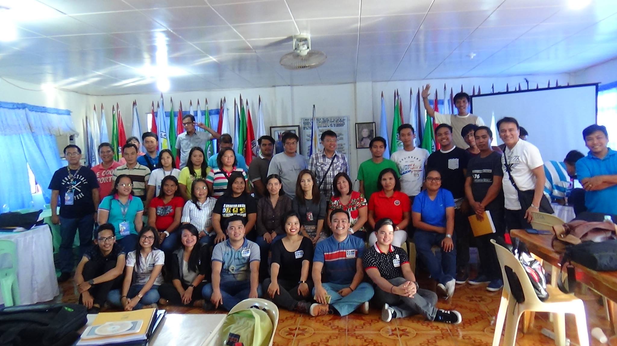 LGU Ilocos Norte with the “dream team.” We’re the ones sitting on the floor (photo from Feye Andal @feyeandal)

The other day I received a cool new t-shirt and sticker, from OsmAnd. This really is my favourite bit of software on my phone, I think. For about the last five years, I’ve not used any other mapping or navigation app, even when travelling far away places (and even when there’s not actually that much data on the map!).

The GPS and camera and the things I use when mapping, along with a spiral-bound notebook with a pen stuck in it.
(The location of this post is not actually where I am while writing it, but it’s the last hill I mapped and feels like a good place to fly the OsmAnd flag.)

I’m responding to an OSMF post ( https://lists.openstreetmap.org/pipermail/osmf-talk/2020-August/007095.html ) here as I’m unsubscribed from osmf-talk as I find it to be too intense / unwelcoming.
The point I would like to make echos some other points raised in the discussion. Namely I feel that this is a good opportunity to assess how osmf communicates in general. As others have pointed out, a commitment to open platforms is great but it does miss huge proportions of our community. Reading the responses, it sounds like (some) board members are basically saying other people should re-post to the wider communication channels. I do not think this is sufficient. The board, and it’s working groups, have a responsibility for making informed decisions and to do so well they should gather views from a wide as audience as possible.
There are services that will post messages across multiple platforms all at once. I strongly recommend that these options are explored. Often these services require a fee, although I suspect we have the right skills to develop something ourselves. It would be great if the osmf committed to making this available to all working groups and local chapters.
So in this case, I think scope creep is worth exploring.
Best regards Rob
Posted by Harry Wood on 18 August 2020 in English.
Last updated on 29 November 2021.

A few days back I noticed a new patch of hyper-detailed mapping appearing on the London map here near Stroud Green Road, with gardens and garden fences all drawn in. It’s impressive! It looks amazing if you zoom in on that patch:
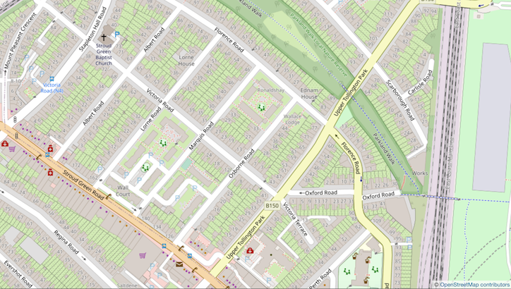
But I felt some frustration when I first saw it, because of the old imbalance of detail issue. I don’t mean to say I’m angry with someone for adding this detail. It’s more a case of being frustrated by an OpenStreetMap problem which we collectively never solved, and I’m frustrated that I can’t actually think of a good solution!
One of, if not the, easiest way to contribute to the current Quarterly Project is through StreetComplete. For anyone not aware StreetComplete is an editor on Android, it’s designed to be incredibly simple and help introduce new users to contributing to OSM. It’s how I started regularly contributing.
Some of it’s questions (quests) displayed to users are directly related to the current Quarterly Project like asking if a given road has a cycle path, and categorising types of bicycle parking. So if you were exclusively interested in the Quarterly Project you could disable the other quests and focus on the ones above.
However some of the other quests indirectly help OSM cycling data, such as road surface, whether the way is lit, names, one way, speed limits, crossings and pavements. They are all incredibly useful to downstream users of OSM cycling data. I think I recommend starting with all of the quests but disabling some high traffic ones, such as building types, you can, and should, come back to them, but if the amount of quests is overwhelming there is no harm hiding them until later.