Diary Entries in English

Recent diary entries

Posted by salisburymistake on 18 August 2020 in English.

It was pretty early into my OSM mapping “career” that I heard about Maproulette. At the time I was too hyper-focused on getting my hometown of Springfield, Illinois squared away to worry about the rest of the map, and I assumed most of the challenges would be beyond my skill level at the time anyway. But yesterday as I was reading through weeklyOSM 525 I was led to the latest Maproulette updates. Having only a vague awareness of it, nothing in the list of new features necessarily excited me, but it reminded me of how unsure of myself I was 4 years ago and how much I’d learned since then. So I decided to give it a shot.

The challenge I’ve really taken to is Duplicate Roads Across North America, which is comprised of a surprising variety of tasks. Many are simply instances of duplicate geometry being imported en masse from TIGER or the like - very easy to disentangle and correct. On the opposite end of the difficulty scale are ways that are parts of complex relations like multiple bus routes, and I immediately “nope” the hell out of those when I see them, lest I screw things up royally.

It’s also interesting to see the mistakes of previous users. Sometimes it’s a simple mis-click just too far from an intersection node. Other times it comes down to sheer laziness, like the many, many instances of users creating multiple parking aisles by using a single way to snake up and down the parking lot, drawing over existing ways on the perimeter. Usually the easiest way to deal with those is to “nuke the snake” and redraw each individual parking aisle, and more often than not you’re adding in one-way directionality that the original editor never included, so you feel like you’re not just fixing something, but adding something.

See full entry

Posted by bo_hot on 17 August 2020 in English.

Hi All,

A quick entry. We’re nearing the finalisation of the new Senior Technical Lead for the HOT_tech team, which we will be sharing with everyone soon. However, in the meantime, we are also on teh hunt for some additional talent to help add to the great team we have. We currently are looking for:

Send me an email if you want to talk through any of these positions in person. Always happy to have a chat :)

Kindness,

bo

Posted by woodpeck on 15 August 2020 in English. Last updated on 31 May 2022.

In the last year or so I’ve taken an interest in mapping trees. Urban trees, to be more precise; I’d probably not attempt to map a forest that way. I try to record the location, type, and size of each tree. With “type” I mean the species, and “size” I express in height, crown diameter, and circumference of the trunk.

Trees are in many ways an antipole to today’s turbo-charged life. I used to frown when people made a big deal about trees (“OMG they are planning to cut X number of trees for this new railway station”), and I thought what’s the problem, you can just plant some elsewhere. But walking the city with open eyes, I saw many trees that have been where they are for longer than I live, and many that will still be there long after I’m gone. Planting trees is not something for a startup where the venture capitalists demand quick returns. If you plant a tree today, it is the next generation that will be enjoying its shade. And that shade can really make the difference between a livable city and one you’d rather just cross in your air-conditioned automobile.

Why?

In practical terms, if OSM had good data about which streets are lined by really big trees with a dense crown, you could run simulations about city climate with OSM data; you could determine the best routes to walk in the summer, or which pub to go to if you want to enjoy a beer in the shade. (Perhaps I should add an explicit survey date so you can algorithmically extrapolate the tree size.) But going further, if information about trees becomes readily available, people will perhaps appreciate trees more, and think twice before cutting them down to make room for a shopping mall.

But mapping trees also brings me back to the beginnings of OSM. I know nothing about trees.

See full entry

Posted by SomeoneElse on 15 August 2020 in English.

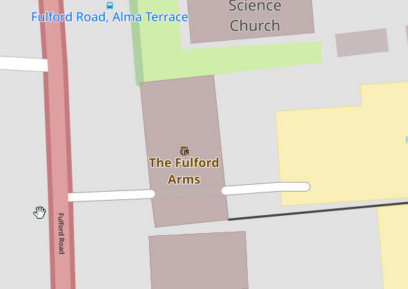
Unfortunately, in England at the moment a number of pubs aren’t able to reopen because (especially locally to me) they’re too small and have lots of small rooms or they’re music venues for which “social distancing” somewhat defeats the object of the event in the first place.

I’ve chosen to show these on this map like this:

Fulford Arms

This is deliberately different from the rendering of “normal” closed pubs:

See full entry

Location: Rosedale West Side, North Yorkshire, York and North Yorkshire, England, United Kingdom
Posted by CjMalone on 14 August 2020 in English.

I’ve started sending some Freedom of Information requests! This is a new world for me, but seems to be going good and has helped a lot.

The first one I sent was for public phone boxes after BT refused to give me a list. It was successful, and I’m now surveying the locations, as well as the ones already in OSM. The two lists differ quite a lot, and interestingly neither is accurate. It makes me wonder if BTs own list is accurate.

So I’ve been taking a lot of photos of phone boxes for Mapillary and that makes me feel like a trainspotter. I promise I’ve not go a weird thing for phone boxes, it’s just an area of OSM that needed some love. Maybe I’ve got a weird thing for OSM…

My next request was for defibs, they still haven’t responded, but I can’t imagine a reason why they wont provide them. Once they do I’ll start surveying and documenting them. I’ve been adding local defibs to OSM for over a year now so it will be interesting to see which ones I’ve missed.

I think anyone else in the UK should consider using Freedom of Information requests, WhatDoTheyKnow is a great tool and makes it super easy. It probably goes without saying but anything you receive from FOIs is not compatible with OSM, you’ll need to get another source (go out and survey).

Posted by Tomas Straupis on 14 August 2020 in English.

Point symbols need generalisation as much as any other type of object, because in small scales they also start competing for the space on the map. Usually (in popular internet maps) the most primitive way of point generalisation is chosen: points are classified, priorities are assigned to classes and then lower priority point is simply not rendered if a point with the higher priority is already rendered in the same space. If there is more than one point with the same piority in the same spot - result is even worse - decision is random.

Such solution is of course not ideal. There are a number of ways to generalise points: displacement, aggregation, symbol combination etc. Only one option, which was chosen for Lithuanian river map, will be described in this entry.

Initial situation is that sometimes rivermap points are so close one to another, that one of them is removed or they overlap:

Overlapping symbols

See full entry

Posted by n76 on 13 August 2020 in English.

I haven’t had much experience in performing an import and the Orange County, California buildings and addresses is the first (and at this rate only) import I’ve instigated.

Other Imports

I assisted with a building import for Cupertino when I lived in Silicon Valley. And I added a couple of buildings in support of the Los Angeles County import a few of years ago. But in both cases my contributions were very small.

Most of my experience with imports has been in attempting to clean them up.

TIGER and NHD

Anyone who has edited in the United States will have run into “TIGER deserts” and I’ve spent my time in purgatory in those deserts. And if you‘ve edited in the rural areas of California may have run into some imports from the national hydrological dataset (NHD) which doesn‘t seem to be much better for water than the old TIGER was for roads. The two can interact in annoying ways. At least annoying to someone who has a desire to keep the number of suspect issues reported by Osmose down. For example:

See full entry

“The last remnants of the Amazon rainforest in Mato Grosso”

Amazon, the world’s largest forest, is spread over Brazil, Peru, Venezuela and Ecuador, among other countrie.

The northern part of the state of Mato Grosso has been under more intense pressure in recent years from cattle ranches, soy plantations and gold mining on indigeneous lands. Indigenous reserves are the fragments of forest that can be observed by aerial imaging.

The state of Mato Grosso is one of the largest in Brazil, and has much to be mapped yet, not only of the Amazon rainforest but also of the Cerrado and the Pantanal.

osm.org/#map=8/-10.436/-59.063

“Os ultimos remanescentes da floresta Amazonica no Mato Grosso” A Amazonia é a maior floresta do mundo, espalhando-se pelo Brasil, Peru, Venezuela e Equador entre outros países.

A parte norte do estado do Mato Grosso vem sofrendo nos ultimos anos uma pressão mais intensa por parte das fazendas de criação de gado de corte, soja e o garimpo nas terras indigenas

As reservas indigenas são os fragmentos de floresta que se pode observar pela imagem aérea.

O estado do Mato Grosso é um dos maiores do Brasil, e tem muito a ser mapeado ainda, não só da Floresta Amazonica mas também do Cerrado e o Pantanal.

Location: Juruena, Região Geográfica Imediata de Juína, Região Geográfica Intermediária de Sinop, Mato Grosso, Central-West Region, Brazil
Posted by mariotomo on 12 August 2020 in English.

this isn’t really about OSM, it’s about how to protect our privacy while on a OSM-centered Telegram group. I manage the Comunidad OSM Panamá Telegram group, and since the Covid-19 struck worldwide, also our group started to be targeted by several types of scammers and spammers, so I looked for options to contrast the events and shield the users of the group from the nuisance.

Initially, I participated in the osmallgroups Rose federation, but I came in disagreement with the most active admins in the federation, as to how aggressively ban potential scammers. My point of view was that, at the first hint of suspicion the person has nothing to do with OSM, with the area, with geography, and is only looking for sources of Telegram user contact details, the correct action is to ban immediately, possibly contacting them with the invitation to tell me that they are legitimate OSM mappers. This was not the shared opinion in that Rose federation, so I left and developed the following protocol.

Each new member gets a message inviting them to mention their OSM user name, and are warned this is an anti-spam measure. Failure to comply results in ban within the first few hours. I then privately write to check the intentions of the user. Up to now I have not had a single false positive. In at least two occasions I saw the person joining and immediately leaving the group.

To reduce the impact of my instructions to Rose in the group, I use a “federation” and a parallel group, where I issue the /fban command to Rose. Rose reacts to that and removes the user from all other federated groups, that includes the Comunidad OSM Panamá. All that people in the real group will see is “Rose removed user Xxx”, something that happens without the Rose avatar. Soon after, this becomes “Rose removed DELETED”.

The other detail that needs to be mentioned, that’s Rose’s ability to log events to a channel. I need that in order to have the necessary user details to invoke the /fban command.

See full entry

Posted by Polyglot on 12 August 2020 in English.

Cycling highways are a ‘thing’ in Belgium and The Netherlands, or rather, they will be.

F212 Zellik

Some stretches already exist, others are still in the planning phase.

The intent is to have them as bidirectional ways for cyclists, ideally 4m wide, without car traffic. Often alongside railroads or canals, sometimes instead of disused railways. Where they cross motorways bridges are planned.

Usually they are also open to pedestrians, horseback riders, skeelers, etc. Some were not open to speed_pedelecs, but that is getting resolved.

In practice there will be certain parts that will always be ‘shared’ with car traffic though and where they cross busy national roads the cyclists won’t have priority for obvious reasons. Building bridges and tunnels everywhere is not possible either.

So more than half of them are still in the planning stage. On OpenStreetMap I like the ability to show where they are planned.

See full entry

Location: Bree, Maaseik, Limburg, Flanders, 3960, Belgium
Posted by Kateregga1 on 11 August 2020 in English. Last updated on 7 September 2020.

Ahead of the State of the Map 2020 conference, which was supposed to take in place in Africa for the first time, but was held online due to COVID-19, OSM Africa surveyed OpenStreetMap community leaders in different countries in Africa, to assess the state of OpenStreetMap in their countries. We heard back from 52 out of the 55 countries in Africa and the results were presented at the conference.

OSM Africa is a network of OpenStreetMap communities from all over Africa working together to grow OpenStreetMap on the continent.

The brightest spots on the map below illustrate substantial amounts of OpenStreetMap node density in different places in Africa.

OSM Node Density

This visualization shows the total number of mapped buildings per year in each country from 2007 to 2020. Which also shows the history and journey of OpenStreetMap editing in Africa.

See full entry

Posted by kucai on 10 August 2020 in English.

I believe I cleared most of east coasts’ osmose warnings a while ago. However, new warnings/errors keep popping up. Either osmose revised their rules, or new (non-local) mappers keep adding stuff that trigger osmose’s detection algorithm.

Also these mappers keep re-aligning existing ways to Maxar, despite there’s no indication that the new imagery is any more accurate than Bing. When 90% of the area was traced to Bing, why shift a portion to Maxar? If that’s the intention, why not shift everything to Maxar while you are at it and make them standardized. It’ll surely do wonders to your KPI, in addition to your ‘smoothing’ of highways.

That and reclassifying highways in a country you never step foot on.

Kratom mixed with Coke sounds good now…

-peace out-

Location: 4.637, 103.401
Posted by mvexel on 10 August 2020 in English.

We’ve been keeping busy this summer! Here are the highlights for the July releases.

Easier Challenge Creation

We completely redesigned the Challenge Creation Wizard, with a focus on gathering the essentials first, and de-emphasizing less-used settings and options. If you have used the Challenge Creation wizard before, we hope you will appreciate the improvements! And if you have never tried to create a MapRoulette Challenge before, give it a try and see how easy it is to create Tasks for fellow mappers to solve!

Leaderboard Improvements

You can now select a custom date range for the Leaderboard. Existing options like ‘Past Year’, ‘Past 3 Months’, etcetera, will still be available. We also show some more detail about the Challenges most worked on by the top MapRoulette mappers.

Global Live Activity View

Have you ever wanted to see where mappers are solving Tasks in MapRoulette right now? You can now, with the new Global Activity view! You can see new Tasks being solved on a world Map, and a live stream of the activity as well. It’s still experimental and we would love to hear what you think about it!

New Translations

The MapRoulette community has been hard at work translating the MapRoulette UI into more languages. It is great to see MapRoulette become available in more mappers’ native languages! It’s easy to participate in the localization effort at Transifex.

See Nearby Next Tasks

When you confirm and finish a MapRoulette Task, you will now see a map showing more nearby Tasks to solve. You can select whether you would like to work on a Nearby Task next, or a Random Task. This new interactive map view can help you choose!

Set Preferred MapRoulette Tags

See full entry

Posted by SimonPoole on 8 August 2020 in English. Last updated on 9 August 2020.

After a large number of delays, mainly to due to late breaking issues with undocumented behaviour changes and other issues due to the androidx migration, I’ve tagged the 15.0.0 release. Installable APKs should be available from google play and the Vespucci github repository in the next couple of days (not from f-droid which is lagging a quarter of a year currently and is unlikely to fix its build problems any time soon).

More information on the future of the app will be announced later.

End of support for pre Android 4.0 devices

Version 15 no longer supports devices with Android versions older than 4.0 / API 14. We’ve now migrated the Vespucci code base to use the “androidx” libraries to provide backwards compatibility over multiple Android versions and there is no feasible way to continue to use the old support libraries that would be necessary for older Android versions.

Import note: even though the app will work on Android 4.0 devices, devices with Android version prior to 4.1 do not have TLS 1.2 support that is required for accessing the OpenStreetMap API since August 2nd 2020. If you are experiencing authorization issues on Android versions between 4.1 and 4.4 see Can’t (re-)authenticate - TLS 1.0 / 1.1 issues.

Support for array like semantics for multi-selects

In some circumstances, tags with multiple objects have array-like semantics (that is a fixed number of elements) contrary to being variable length lists. A typical example are lane related tags, which contain the number of elements in the lanes (or lanes:forward and lanes:backward) tag. There is no practical difference for tags that need to have a value for every element, but in the case of tags that have free form, potentially empty values, for example destination:lanes, there was previously no way of indicating this in the preset.

See full entry

Posted by LCCWG on 8 August 2020 in English. Last updated on 19 October 2020.

With the Local Chapters & Communities Working group (part of the OSMF), we did a quick review of the websites of all the official Local Chapters. This is quite interesting, as these sites all have basically the same mission - and still are hugely diverse.

Ireland website

All of these website focus on helping mappers find the community and/or to help outsiders understand what OSM is all about. Maybe surprisingly, none of these websites are map-centered. On some of them, it’s hard or even impossible to find an interactive map. There’s several creative attempts to build the content around a map - especially the Czech website is quite succesful at that.

See full entry