Diary Entries in English

Recent diary entries

Why and how

In Slovakia we have electronic cadastre available and it contains buildings in vector format with building conscription numbers (in our country it is conscription number Key:addr:conscriptionnumber ). These information are public and we have some smart OSM users that created a conversion possibility to get it into OSM maps KaporSKAddress#Conscription_numbers_import .

I have decided that I will use available method that takes cadastre house numbers and assign them to OSM map buildings in my town and then I will verify how correct these data are. Goal was:

  1. have houses with numbers searchable in OSM. It was found to be helpful also for ambulances in case of emergency to have searchable map!
  2. to keep OSM map up to date - to reflect reality which is goal of OSM
  3. by curiosity to see how precise are cadastre data

My town has approx. 1600 inhabitants and 632 houses plus some garages, cottages and huts. Town has approx. 10 streets.

Fast part

Building shapes are already imported into OSM for most of Slovakia for some time. Though, importing conscription numbers can’t be fully automated and it can be tricky. Jose helped me with import process (thank you!) and it took less than half a hour; This was the first commit.

Slow part

Import process shown that in about 15 cases different houses had the same house number. I decided to resurvey whole village to verify all the house numbers (because of reasons 1-3 above).

So I have printed out zoomed OSM map with visible building numbers on paper. I walked around the town and noted down if something was not correct (I have done this in 4 separated sessions). After each session I started JOSM and corrected houses that needed correction, removed ‘import notes’ from houses, added source:conscriptionnumber.

My findings

See full entry

Location: Sološnica, District of Malacky, Region of Bratislava, Bratislavský kraj, 906 37, Slovakia
Posted by tmcw on 24 August 2016 in English.

There’s long been a desire & incoming wish for iD to be modular. Modular is a pretty general term, so I’ll narrow it down into three general goals:

  1. Modules as a way of building a system. Using rollup, browserify, etc., in order to structure code and separate internal components in a nice, predictable way.
  2. Modules as a way of letting other systems include yours. Generally, in JavaScript-land, means publishing to npm.
  3. Modules as ways to include new code in your project. This is more in the vein of iD plugins. Supporting plugins would let us support contentious or rare needs without bikeshedding their inclusion to the main project.

With the help of Bryan, Kushan, David, Beau and Martin, we’ve made significant progress toward the first goal and are nearly at the finish line. iD will be switching from a system where we concatenate source files and use GNU make as a build process - to one that uses rollupjs to build a bundle from JavaScript modules. The expected benefits are big, for maintainers:

  • iD no longer relies on the global namespace for dependencies like d3, so there’s less chance for conflict.
  • misnamed requires or invalid requires will be caught early
  • we can use npm modules for our dependencies, rather than keeping them in the project’s source tree
  • we’ll be able to build a faster and more reliable environment for development
  • we’re upgrading d3 to v4, keeping it in line with the changing software world.

This doesn’t immediately win us (2) and (3) but it pulls them closer. Soon, a new editor could reuse iD’s data model, and iD could load new functionality from a plugin.

And there likely won’t be any user-facing change as part of this port. This is the stage where the developers throw tens of hours into the low-level guts so that plugins can be possible and long-term maintenance can be less painful.


See full entry

Location: Ward 2, Washington, District of Columbia, United States

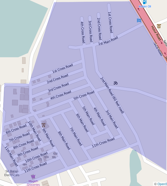
I recently moved to Singasandra and realised that being a new colony, this area was very badly mapped. The creation of AECS(Aeronautical Engineers Cooperative society) Layout involved the area being carved out of Chikka Begur village, Singasandra. Not the problem is that the area is not not mapped correctly on any official or non-official platform. Let me Illustrate

The highlighted area is designated as AECS B Block(Verified on location) Given that its a new area, there are very few location markers placed by authorities- precisely 3 in the area(highlighted below) (1) Marked as 2nd Main Road (2) Marked as 3rd Cross Road (3) Marked as 2nd Cross Road

(1) Marked as 2nd Main Road (2) Marked as 3rd Cross Road (3) Marked as 2nd Cross Road

These are the only 3 physical markers in the area and the rest of the area just has to guess its own address. All the roads have been marked out on the basis of these 3 reference points. But there are some major issues here.

See full entry

Location: Singasandra, Bengaluru South City Corporation, Bengaluru, Bangalore South, Bengaluru Urban, Karnataka, India
Posted by mtc on 24 August 2016 in English.

Among the things that have changed, since I was previously an active in 2010, is the way parking lots are defined. When there were none on the map, a parking lot area appeared to be a Public Parking Area, such as one that you might see on a road sign. The information seemed to be directing you toward a widely acceptable place for parking.

Today, every flat, paved place that one might find a few vehicles left turned off has a parking polygon. So, the meaning of the map has changed, but the data structure has had trouble keeping pace.

I have learned about how parking lots are used in today’s OSM. I have attempted to add the “access” tag to the parking lots in my area, including the data that I entered many years ago. The vast majority of parking lots are privately maintained, but without the “access” tag defined, the (unofficial) default is public since they are accessed through public roads. Certainly many renderers put a (P) symbol which is commonly used for Public Parking Areas. That means more work for the mappers. I spent many hours adding “access=customers” to commercial locations or the key “access=private” to more remote locations.

The examination of social structures is one thing that gets me so excited about mapping. And nothing looks at the public-private social contracts more closely than the “access” tag. We can talk about whether the data or the renderer should be defaulting to public or private, but it comes down to this basic question: “Who is permitted to use that place?” Some of the information in OSM is the very complicated answer to that question. Little wonder it is hard to keep that data correlated with our assumptions.

This diary post last week outlined an overarching goal of making OpenStreetMap navigable, and our intent to investigate and add missing turn-restrictions in Berlin, Stuttgart, and Wolfsburg using Mapillary as a source. We received some good questions from the local OpenStreetMap community about using Mapillary as a source. Considering the concerns of the community, we did a preliminary research on the Mapillary imagery to ascertain their recency. We want to share our findings here.
Here is an animation showing Mapillary traces in Berlin, Stuttgart, and Wolfsburg spanning the last six months (March - August 2016). Not surprisingly, Berlin was found to have the best Mapillary coverage. The coverage in Stuttgart and Wolfsburg was sparse in comparison.

Berlin2 Berlin Mapillary Coverage

See full entry

I’ve been experimenting with generating my own vector tiles and client-side rendering with Tangram in order to figure out how to best write a style in its language.

Tangram is a GL-based renderer written by Mapzen and normally used with their Tilezen vector tiles, but I’m interested in being able to make my own vector tiles with different cartographic choices.

Having a diverse selection of vector tile schemas is important, as is avoiding a situation where only large players in the market can get involved like right now.

For a toolchain I used osm2pgsql with ClearTables and Mapnik via Kosmtik to write vector tiles. With the demo I’m serving pre-rendered vector tiles from disk, but Kosmtik is useful in development with it’s xray functionality. I input the style into Tangram Play, a web-based editor that automatically reloads the map when you change the style.

The cartography and vector tile definitions are loosely based on OSM Clear, a demo style I wrote. I didn’t want to learn the language while designing new cartography at the same time. Being a learning exercise I don’t consider the style complete or free of bugs.

The demo page is on my server at http://tangram-clear-demo.faramir.paulnorman.ca/ with the style and vector tile code at https://github.com/ClearTables/tangram-clear-demo.

I’m not sure what direction I’m going to take next as I don’t have any particular style goals right now, or collaborators.

Cross-post from https://lists.openstreetmap.org/pipermail/dev/2016-August/029448.html

Posted by alexkemp on 24 August 2016 in English. Last updated on 26 August 2016.

A recent Diary entry (A Suggestion to Fix Poor LSN in the UK) contained the phrase “Why those facilities fail for a substantial part (40%) of the UK”, and I promised to publish the raw data that led to the ‘40%’ claim. This is the fulfilment of that promise and be warned, it is long & intensely computer geeky.

In brief, that earlier Diary entry said:

  1. Location, Search & Naming facilities (LSN) require the presence of an “admin_level=10” (civil parish) area in the UK
  2. 40% of the UK does not have such an area, as it is unparished
  3. (thoughts on how to fix it)

The above both is, and is not, true (real life is usually a bit more complicated than that) but it was the best that I could manage & wanted to get the debate kicked off. In addition, some later spreadsheet-work (see bottom) indicates that it is more like 60% for the nations’ cities, and 100% for all the major conurbations. Now for the methodology of acquiring, plus full results that led to, the 40% claim…

A site maintained by The Maarssen Mapper contains a page of all UK Civil Parishes in the form of GPX file downloads. The top of each file has an XML header that looks like this (this one is Birchgrove_Community):—

See full entry

Posted by Amisha Singla on 23 August 2016 in English. Last updated on 24 August 2016.

I decided to spend some time mapping on OpenStreetMap after starting at Mapbox to help build better mapping tools later. After having show and tells with Mapbox buddies, I started off with mapping my hometown. Though I had not very perfect memory of the places in my hometown as I am away from it from many years, but there were few places which I was sure about. As it is advised to add data with 100% accuracy only, therefore I tagged only the sure places in OSM. When I downloaded the data for my city Gandhidham in JOSM, to my surprise, the city was well traced by a remote mapper. Therefore I worked on adding known POIs. It was fun to look for my home from the satellite imagery and tag its address.

Next I traced roads in city called Raipur. It was like taking part in an enjoyable drawing task while keeping a few rules in mind. Adding intersections, junctions, classification of roads has a huge impact on the routing. So I did that quite carefully.

See full entry

Posted by Amisha Singla on 23 August 2016 in English.

What is Mapping?

It is an operation which associates elements of one set with the one/more elements of another set. When we talk about mapping in OpenStreetMap, the similar concept is followed. In that, we associate the real life objects (Home, Parks, Schools, Roads, Water bodies) to 2D elements like node, ways and polygons. This means that we can traverse any place virtually by looking at the map and can a get a sense of directions, locality, etc.

What are the objects which can be mapped?

It can be mapping different amenities, POIs, roads, buildings, water bodies, turn restrictions, different transport networks, Trees, Street lamps, so on. This list is never ending as each of them has a special purpose of being added in the map. The more detailed it is, the more it helps in understanding the place geographically. Details

How do we Map?

Basically there are two steps involved to map a place:

See full entry

Location: Hoysala Nagara Central, Bengaluru Central City Corporation, Bengaluru, Bangalore North, Bengaluru Urban, Karnataka, 560008, India

With an aim of making OpenStreetMap more navigable and accurate in routing, we started mapping turn restrictions and exit-destinations in Canada in its five important cities: Toronto, Ottawa, Montreal, Vancouver and Calgary. The tasks which spread over a month have been completed; we have finished adding and validating both turn restrictions and exit-destinations in the selected cities of Canada with the support from the OpenStreetMap community.

Summary of improvements

Mapping turn restrictions was flagged off on 21 of July with data team and the community working on adding missing turn restrictions and validating the ones that are present.

As the mapping progressed, workflow was getting updated every time the team had some doubts regarding how best to map a particularly different turn restriction that was detected. The questions we had were posted on the mapping ticket we used and the community got back to us almost immediately with clarifications to our questions. We completed both adding and validating turn restrictions in 14 days.

Exit-destination mapping started on August 11. For exit and destinations, a slightly different approach was followed, unlike how we mapped previously using only checkautopista2. Each highway was considered a separate task, which was integrated into tasking manager, with a specific link to checkautopista2 that loaded that particular highway that was selected using tasking manager.

Below is the full breakdown of how many turn restrictions and exit-destinations were mapped:

See full entry

Posted by mvexel on 23 August 2016 in English.

I am collaborating with agencies in Texas to update both OSM and Texas data. The pilot project deals with cemeteries. I received a file with almost 7000 cemetery locations. (Even if the idea that there are more people living today than have died thus far in human history turns out to be a myth, I think that is quite a lot!).

The first phase of this collaboration is to see which cemeteries in the Texas data actually exist. We will use MapRoulette for that. Simply go to the Cemetery challenge at maproulette.org and start looking at tasks.

If you see a cemetery in the aerial image, click ‘skip’ to go to the next one. If you don’t see a cemetery, click ‘False Positive’. If you are in doubt, click ‘skip’.

How can you tell if there is a cemetery? Sometimes it is hard. Look for fine patterns defining the plots, and usually there will be a service road connecting the cemetery to the road network. Sometimes, in larger cemeteries, you may also see paths inside the cemetery. Finally, the marker may not be right on the cemetery, so look around a bit as well. Below are some examples of cemeteries and non-cemeteries.

Once we complete stage 1, we will turn to mapping all the cemeteries that are not yet in OSM yet!

See full entry

Posted by kepta on 22 August 2016 in English.

3 months have passed and GSoC is about to an end. This small diary post showcases my contributions uptill now and it also lays down my next actions.

Major Contributions

### Lane editor The lane editor is my primary objective of the GSoC for this summer. These diary posts (1, 2) can be referred to get updated with the work.

Currently, most of the functional code is ready with 81 test cases testing most if not all edge cases possible. This code parses the osm data and gives a nice JSON output, which should then be supplied to the rendering.

Making iD modular

The iD contributors felt the need to start using the new ES6 module system back in April. I helped in the phase 1 and phase 2 of this process.

OSM hackday

I was a part of organizing team of this small hackday at Mapbox Bengaluru. More info

My pull requests

My commits

Next Steps

Well GSoC 2016 is approaching an end, but not my contributions. There are lot of things pending in my bucket list. The first thing I would like to finish in the coming months would be the lane editor’s UI and deploy it for the use of OSM community.

I am really proud to be one of the core contributors of iD and would really like to thank the community, my mentor Bryan Housel and Google for the awesome GSoC program.

An OpenStreetMap contributor, Kushan

Posted by parambyte on 22 August 2016 in English.

I love the Columbus V990 as a tool for data gathering, not only for its long battery life (about 12-16 hours) and extreme ease of use, but also for its precision and price. Everything works. But what doesn’t is its cover. I took the dimensions of the V990, and had a sleeve handcrafted. Its available for sale at Flipkart.com just look for StudioLove (one word).

I am hoping to create a small fund out of sale proceeds to help the community.

Columbus V990

These are hand made in Dharavi. Someone has nicely mapped the bylanes of Dharavi.

Location: G/N Ward, Mumbai Zone 2, Mumbai City District, Maharashtra, India
Posted by Manjurul Islam on 21 August 2016 in English. Last updated on 23 August 2016.

OSM data is very helpful for disaster risk management. This data is helpful for identification of vulnerable places ,way of passing, important key indicator etc. As the proper authority get the information they will take necessary steps to reduce the destruction of disaster.in this map we get the data about building condition, material, structure by research this information govt. /relevant authority will identify the vulnerable places and take necessary steps to reduce the vulnerability ,to reduce the damage of any kind of disaster . By using this data Bangladesh Red Crescent society or like this type of voluntary organization or Government organization like fire service , civil defense will plan their search & rescue operation. It will helpful for VCA(Vulnerable Capacity Assessment).

Manjurul Islam

Posted by alexkemp on 20 August 2016 in English. Last updated on 8 February 2019.

This is a research document; it is going to attempt to explain:—

  1. The fundamental basis on which Location, Search & Naming (LSN) facilities in OSM work
  2. Why those facilities fail for a substantial part (40%) of the UK
  3. How to fix it

You need to know that the writer has been mapping for only 5 months, and therefore only part-understands what he is talking about. One (possible) advantage is that his is a fresh eye, plus he has the ability to think for himself. As the writer enjoys stories, much of this will be presented in that form.

On Thursday 9 June 2016 I began to map outside of my home patch in Nottingham NG3 and met the Boundary marker which, since 1877, has marked the Boundary Line between the City of Nottingham and Gedling, and also between NG3 & NG4. I was now heading for Carlton, Gedling.

One feature that had been common throughout my NG3 mapping was that LSN had consistently failed with OSM. When I was mapping close to St Anns OSM said that I was in Thorneywood, and so on. By the time that I reached Carlton I’d gotten the basic map methods under my belt & could pay more attention to the condundrum of the fact that when I was working in Carlton (a Suburb) OSM said that I was in Bakersfield (at the time a Neighbourhood, but now a suburb), or even Thorneywood (another Neighbourhood).

Practical examples can focus the mind, and this post is typical. I placed the Diary arrow in Highfield Drive, Carlton, but the result was: “Location: Thorneywood, Sneinton, Nottingham, East Midlands, England, United Kingdom”, which isn’t even the correct District. That was just embarassing.

See full entry

Jorieke, a 28 years old Belgian, has spend a lot of time the past few years to support local OpenStreetMap communities all over the world. She worked on several projects in Africa, Europe and Asia to train people and to promote OpenStreetMap by local and international players.

Jorieke at the  Mapfugees in Duinkerke

Where and when did you discover OpenStreetMap?

See full entry