Diary Entries in English

Recent diary entries

Posted by alexkemp on 20 August 2016 in English. Last updated on 8 February 2019.

There has been an increased alertness to my changeset comments in recent weeks. I thought it reasonable, since I’m half-inventing words, to explain at greater length what on earth was going on.

I started mapping in March by entering house numbers & names onto the map & have continued doing that most days since. I’ve been using terracer within JOSM to do it, including associatedStreet relations for each house, something that terracer made easy. The team that maintain JOSM have been working hard to allow it to work under Java-8 (the dependency was previously on Java-7); however, many plugins (including terracer) are unmaintained and, as the chief developer informed me, they do not bother to check what effect their changes have upon any plugin.

Shortly after I started, version-32158 started crashing JOSM when certain options were selected and, shortly after, it was NOT possible to create a relation with terracer under any circumstances. That circumstance continues today, using the current-stable JOSM-10786 (terracer-32699).

This is how to create a new associatedStreet relation:

  1. Select your street ways + all houses
  2. From the menu, choose menu:Presets | Relations | Associated Street
  3. From the dialog, Enter the name of the street
  4. Press “New relation”
  5. (house members should get a ‘house’ role, whilst the street ways get a ‘street’ role)

That was fine, and it worked, but I only knew how to create a new relation, and not how to add new members to an existing relation. Consequently, and especially with big roads, the number of relations for each road began to grow. I was fragging (fragmenting) the street relations.

Eventually, I discovered how to add new houses to an existing associatedStreet relation. This is how you do it:

See full entry

Location: Woodthorpe, Arnold, Gedling, Nottinghamshire, East Midlands, England, NG5 4JX, United Kingdom
Posted by MRPockets on 19 August 2016 in English.

Project Complete

I have finally gotten around to finishing up the bits & pieces of Pinedale proper that I am aware were still unmapped (according to the goals I gave myself for this project). I believe now that I have succeeded in my stated goals!

Mapping Still Needed

Pinedale proper is extensively mapped (though of course there is much that could be added: sidewalks, more POIs, etc) but the outlying areas as still mostly unmapped (excepting roads). While I will continue to map the area as I can & have a desire to do so, I will not be putting much concentrated effort into it. If there are any other mappers in this area, I invite you to put some work into the areas that are still lacking.

Location: Pinedale, Sublette County, Wyoming, 82941, United States
Posted by nammala on 19 August 2016 in English.

Here are a few observations from the OpenStreetMap edits between 8 August - 19 August. Most of these helped us understand common mapping issues faced by the new mappers.

  • Added untagged nodes 1, 2. These were reverted by the community.
  • Added nodes with numbers as names 1. Reverted by community.
  • Bad imports of data 1. Reverted by commuinty.
  • Deleted waterway=riverbank , natural=water tags and stream 1, 2, 3 respectively. Asked for clarification.
  • Deleted building 1. Asked for clarification.
  • Deleted highway=service roads inside the park 1. Asked for clarification.

It is always good to let the user know of such issues and encourage them to do active and quality contributions to OpenStreetMap.

Looking forward to another roundup next week. Happy Mapping.

OpenStreetMap has had a spike in tiles usage and, as I understand, the decision among those in charge was to limit tiles usage. Ilya Zverev has written a good summary on the decision in his blog: (use Google Translate) http://shtosm.ru/all/dlya-kogo-tayly/ His main point is that OSM is not liable to provide tiles to anyone but the mappers.

OSM owes you nothing, to put it shortly. And it’s not a commercial provider to do it for a reasonable rate. That’s perfectly true. Except that this case is another step to a death spiral and makes the project end come closer.

I saw exactly this happen in an amateur community network that I used. Its approach was exactly the same and it led to an eventual death of the project. OSM resembles it in many details, decisions and explanations. The community network also was very righteous in its statements.

Noncommercial provider

(I have to clarify the state of the internet providers, to make it clear. You may omit this paragraph.) In 1999, the internet providers in the city consisted almost entirely of (audio) dial-up, that is 56Kbit top speed. The phone network was state-owned, it tried hard to jump on the DSL wagon, but only upgraded its stations by 2004. Unlimited Ethernet or DSL appeared only in 2006-7.

So, in 1997, some 5 guys in a big condo near me, tired of modem speed, connected their computers with coaxial cables and Ethernet cards to make a local network. They were very enthusiastic and made all sorts of things: bought 56K modem and an unlimited plan, installed 24/7 servers, made an internal website with lots of information, and so on. In 2000, they organized consumer cooperative and finally bought in bulk a 1Mbit Ethernet line. By 2001 there were about a 100 users, and I was in 110s when I joined it in October or November.

See full entry

Location: 54.863, 83.104

The SciGRID power network model, written in Python, is mainly based on the “power” relations data available in openstreetmap.org under ODbL. This data constitutes the skeleton of the SciGRID model.

We are pleased to announce the SciGRID International Conference on Power Grid Modelling and the calls for abstracts and papers. The conference aims at presenting state of the art research on power grids and energy system modelling by bringing together experts from the power network and the energy system modelling communities. The goal is to share knowledge and help identify the common problems encountered in research, industry, and software development topics.

For more information you can contact me or visit www.scigrid.de

When someone tries to compare OSM.org and any cartographic web service (usually, Google) it is hard to make people trust you when you telling them it’s nothing more than technical website mainly intended for internal use by mappers. Same problem applies to OSM Standard (aka Mapnik) style. Finally, there is something more or less official to show them as a proof.

Andy Allan just gave this reply on question about expanding tile distribution infrastructure. (Full message text with added emphasis.)

We should be clear here - we have more than enough capacity to handle all the traffic generated by our mappers, editing software and every website run by the OSMF, local chapters and local mapping groups. Several times over.

We’ve always allowed other people to use our spare capacity on the tileservers, but recently it’s got completely out of hand. Most of the use of our tileservers has become developers looking for free maps, nothing to do with the rest of the project. Often these are commercial companies who are using our tileservers and selling their apps. Subsidising commercial companies isn’t the best use of community donations and volunteer sysadmin time, when there are many alternative services (such as those run by CartoDB, Stamen, etc) that provide zero-cost map layers based on OSM data anyway.

We do have plans to scale the tile infrastructure later in the year (cascading an old database server), in addition to the current process making sure that our OSMF tileservers are being mainly used for OpenStreetMap related projects.

I just want to keep it here to be able to quote it for any stubborn people, insisting on their own view of OSM infrastructure functions.

Posted by alexkemp on 19 August 2016 in English.

Calverton resplendent

(that’s a mixture of English & French lavender in the foreground)

One of the glories of English gardens is the astonishing abundance of flowers. Calverton Avenue was built by Gedling Pit in 1954 to provide housing for 80 employees. One of those houses today has the most beautiful and astonishing variety of flowers blooming under the August sun. The lady of the house was kind enough to allow me to photograph some of them. Here is a closer shot:—

See full entry

Location: Woodthorpe, Arnold, Gedling, Nottinghamshire, East Midlands, England, NG5 4JX, United Kingdom
Posted by alexkemp on 17 August 2016 in English.

I was going stir-crazy & got back onto the road to do some field-work in Valley Road, only to discover this:

tweety pie in Valley Rd

(you may be more mature than me, but I found it funny; as a child I liked Warnor Bros cartoons way more than Disney)

I’m sorry to have to say that I found the 1930s detached & semi-detached houses in Valley Road & Prospect Road deeply boring. However, the residents were most helpful in helping me stem off dehydration by providing water + salt on request (both roads are on a hill & it was hot hot hot).

There were two interesting houses in Prospect Drive. This house board was made in Kenya:—

See full entry

Location: Woodthorpe, Arnold, Gedling, Nottinghamshire, East Midlands, England, NG5 4JY, United Kingdom

by Maliha Mohiuddin

Every year Bangladesh is affected by the devastating natural and human-induced disasters . It is one of the most vulnerable countries because of the geographical location as well as meteorological characteristics. According to Country Disaster Risk Management Status Report 2016, during the 10-year time frame of the Hyogo Framework for Action (2005 to 2015), over 700 thousand people lost their lives and the total economic loss was more than $1.3 trillion. We all know that it is impossible to turn the scale of vulnerability into 0% but we can reduce the risk and vulnerability by merging with the new technology .The new dynamism of Open Street Mapping can create a huge difference by contributing to the humanitarian purpose . Open street Mapping is a free licensed mapping system , anyone can get free data for using the web -based mapping and anyone can edit the maps. With the collaboration of Dhaka City Red Crescent Unit (BDRCS) and OpenStreetMap Bangladesh community (OSMB), have arranged two days training for the students of Institute of Disaster Management and Vulnerability Studies. The main vision of this OSM training for the disaster management students was enriching their skills by using the open geographical data to identify the hazard , disaster , the vulnerability of any area , navigational and other humanitarian purposes . Moreover, the IDMVS faculty wanted to improve the capacity of the students, to do web –based map analysis instead of social mapping in their academic research. In 12 -13 August 2016 , the TOT (Training of Trainers ) on OpenStreetMap (OSM) was conducted at Lecture Theatre Building [First Floor] , University of Dhaka, Dhaka. This training was started from 09.00 am -05.00pm and it solely attended by the 20 students of Institute of Disaster Management and Vulnerability studies , University of Dhaka .

See full entry

Location: Modhubag, Noyatola, Mogbazar, Dhaka, Dhaka Metropolitan, Dhaka District, Dhaka Division, 1200, Bangladesh
Posted by manoharuss on 17 August 2016 in English.

Following up on a recent series of posts that summarized the suspicious changes on the map, an interesting question that we bring to the community - what is a good amount of time to wait for a response from an inexperienced mapper before fixing or reverting their edit?

You can see examples of such changesets that do not seem right on these posts:

Observations from last week

  • User added unexplained nodes with alphanumeric names: 1, 2. A community member commented on these changesets and reverted them.

The community is great at responding to mapping issues but there are few issues lying under the rug. When we see unexplained edits without a clear comment or source, we do not go and fix them immediately, but let the user know the best practice and try and encourage them to to become a better mapper.

During the last 3 months the data team at Mapbox has commented on around 78 changesets and fixed only around 10 changesets. Over the course of last 1 year we have commented on around 250 changesets that did not get a reply from the user (quick map of these changesets).

It is a very subjective question to ask how long do we wait before we take the plunge into fixing or reverting changesets like these which may be suspicious, but is difficult to verify from the original mapper. Happy to hear how you approach this issue.

Posted by mtc on 16 August 2016 in English.

Big personal milestone met today. Throughout my town, I have mapped all the roads through GPX tracks, and I removed all the TIGER:reviewed=no tags, in openstreetmap. Admittedly, I do live in a small town, but it is a good feeling to finally say that I have seen first-hand all of those little roads.

Where to go now? There is really so much left to do, with stop signs, buildings, street addresses, land types, and social structures. But, I am still excited to continue street mapping, so I will be pushing into the bordering towns and verifying the TIGER data there.

I am starting to find uses for more tools. I used OSMAnd+ to capture some pictures, for the first time. The JOSM integration for GPX images is really terrific. I have installed openstreetview, and I am looking forward to trying that on a future ride. There are still many tools left to explore, and I will continue to improve my street verification workflow.

Posted by mvexel on 15 August 2016 in English. Last updated on 24 August 2016.

After almost a year of thinking, development and testing, the OSM team at Telenav is ready to present OpenStreetView to all OSM mappers! OpenStreetview (OSV) is the free and open street level imagery platform designed 100% with OSM and mappers in mind.

We officially presented OSV to the OSM community at State of the Map US where we had a 20 minute talk and a booth where we gave away crazy little remote controlled cars to everyone who signed up :). The cars were gone quickly – almost half of the people at SOTM US signed up! - but you can still see the talk thanks to the great SOTM US organizers who had all the sessions professionally recorded. If you have 20 minutes and don’t like reading, watching that video is going to be the best way to be introduced to what OSV is and how you can use it to improve OSM. Or if you are coming to SOTM in Brussels, you can come meet our team there (more remote controlled cars? Who knows!) and attend the workshop.

booth

The OpenStreetView booth at SOTM US

See full entry

Posted by mtc on 15 August 2016 in English.

Accessing forested trails is a particular interest of mine. Learning about a new accessable trail encourages my participation in OSM. Discovering a couple “secret trails,” by studying and updating maps, has given me new - and especially enjoyable - local recreation areas. In order to record more GPX tracks in wooded areas, I need some verification that the lands are publicly accessable.

The city government holds many information records about the land, and I asked their advice today. As I expected, several of the first people that I met did not fully understand my interest in exploring wooded areas, but they kept directing me toward more knowledgable people: from City Hall, to Public Works, to Engineering, to the GIS Coordinator.

Finally, in the small office of another map enthusiast, the city maps of land ownership were examined, including a two hundred page online PDF of land lots made public after being abandoned by their owners. I would never had thought to look there.

This information will keep me very much engaged with mapping the woods in my area. I recommend asking for help to all other OSM mappers. I found people in these city offices understanding of a desire to explore natural areas, and I never found myself defending my interest in learning about public spaces.

I appreciate the patience everyone gave me. Great seeing an actual office where GIS is used in city planning.

Posted by Sawan Shariar on 14 August 2016 in English. Last updated on 27 October 2016.

If you are a Trainer of OSM or YouthMappers Platform you may have to face some common but very important questions. I want to try to find out this kinds of questions and give its suitable answer.

01. What is Map?

—–> Answer: A map is a symbolic depiction highlighting relationships between elements of some space, such as objects, regions, and themes.

02. What is OpenStreetMap?

—–> Answer: OpenStreetMap is a free, editable map of the whole world that is being built by volunteers largely from scratch and released with an open-content license. OpenStreetMap is, as the name suggests, an open source map of the world (www.openstreetmap.org). It has been built up in a concept similar to Wikipedia. It is called the free wiki world map, a collaborative project to create a free editable map of the world. A digital map is always handy for various purposes. It can be used in navigation, in research, in development of location based applications. When the map is free, its usability is guaranteed for everyone. And as OpenStreetMap is open source, its development is rapid and dynamic.

03. Why OpenStreetMap?

—-> Answer: OpenStreetMap is a free, editable map of the whole world that is being built by volunteers largely from scratch and released with an open-content license.

04. Why don’t you just use Google Maps/whoever for your data?

—-> Answer: Because that data is copyrighted and owned by multiple organisations like the Ordnance Survey. Google/whoever just licenses it. If we were to use it, we’d have to pay for it.

05. Who owns OpenStreetMap?

—-> Answer: You do. The data and software is owned by you, the contributors. There is an organisation called the OpenStreetMap Foundation which exists to protect, promote, and support the project, but does not own the data.

06. Why would you use OpenStreetMap if there is Google Maps?

See full entry

Location: Nilkhet, Azimpur, Dhaka, Dhaka Metropolitan, Dhaka District, Dhaka Division, 1205, Bangladesh
Posted by mtc on 14 August 2016 in English.

Today, I searched for a school in OSMAnd+, with a POI search. I was surprised to see so few in the area, so I jumped onto JOSM to investigate.

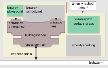
I saw some schools with building=school tags, while other schools had amenity=school tags. What is going on here? On to the OSM Wiki to learn more. wiki image Ah, ha! The schools are supposed to have a border defined which uses the amenity=school tag, for the perimeter of the school grounds. The amenity tag, not the building tag, should carry the name of the school complex. I assume the building’s name= tag is used to define the name of the building, instead. Clever.
There are some non-obvious ways of doing things in OSM, but the more that I learn, the more other OSM methods become more intuitive. Are there other boundaries that are better defined by the amenity= tag?

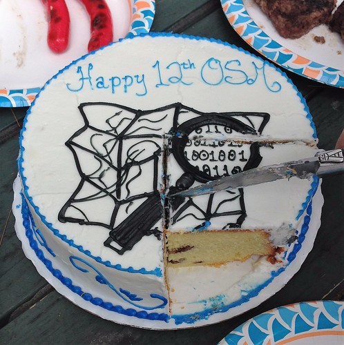
Today, Ruth and I attended the birthday party for OSM at Greeley Park in Nashua, New Hampshire USA.

It’s always nice to see old friends and to attach names and faces to folks you recognize from diary entries, mailing lists and changeset comments.

It’s amazing how fast a conversation can start when someone says “How do you…..?

Several of the attendees were

  • A 13 year old girl who’s made a website for the trails in her town using a tailored cartographic style.

  • One of the “fathers” of the great MA imports.

  • A prolific area mapper who has moved to Portland OR

I’ll be checking the OSM Birthday wiki next year to see where the party will be.

Many thanks to rozzin for organizing this event.

Location: Nashville Historic District, Ward 3, Nashua, Hillsborough County, New Hampshire, 03064, United States

The key highway=* is the main key used for identifying any kind of road, street or path. The value of the key helps indicate the importance of the highway within the road network as a whole. See the table below for an ordered list from most important (motorway) to least important (service).

“Highway tagging samples”

Roads: motorway, trunk, primary, secondary, tertiary, unclassified, residential, service

Link Roads: motorway_link, trunk_link, primary_link, secondary_link, motorway_junction

Special: living street, pedestrian, bicycle road, track, bus guideway, raceway, road, construction, escape

Paths: footway, cycleway, path, bridleway, steps, escalator

Sidewalks : sidewalk, cycleway lane, cycleway tracks, bus and cyclists, lanes:psv, busway

Lanes: number of lanes, direction instructions (“turn lanes”), signposts

Data Source: osm.wiki/Key:highway osm.wiki/WikiProject_Bangladesh#To_Know_more_about_Bangladesh

Location: Katabon, Shahbag, Dhaka, Dhaka Metropolitan, Dhaka District, Dhaka Division, 1205, Bangladesh
Posted by Atikur Rahman atik on 13 August 2016 in English.

Atik

In 14 May 2015 i joined the #OpenStreetMap team as a mapper . That time i feel so much bad & think why i do this ? But after a long time with osm i learn lot of thinks. Now i am a osm map trainer . That’s why i know some common question’s answers . Now i share it for new comer who recently joined or want to be joined it .

  • Why Map ?

=> When you trace roads, buildings and houses on a Map that will aid in humanitarian missions. So..

  • What Can I Do ?

=> Join the community of online volunteer mappers. Make a powerful contribution with an Internet connection and basic computer skills, even if you do not live in the area you are mapping. Use satellite imagery to trace the outlines of roads, structures and land features for the creation of openly available data used to produce maps that help the humanitarian and development community.There are several ways to get involved and aid humanitarian crowd-sourced mapping initiatives. This site provides one such path.

See full entry

Location: Nilkhet, Azimpur, Dhaka, Dhaka Metropolitan, Dhaka District, Dhaka Division, 1205, Bangladesh

12th August, 2016 - a day of my lifetime achievement. Ahasan vai just started talking about the techniques of playing games with maps and I was like a baby seeing its desired toy. From yesterday morning to today’s evening, it gave me a world full of enthusiasm, love for work and a toy for playing with the world. Love this mapping, proud to be a mapper and wish to make a bunch of mapper too. Hope for the best. We shall overcome.