 OpenStreetMap

St Catherine church
Diary Entries in English
Recent diary entries
Posted by mapmakerdavid on 19 February 2019 in English.

Hello, fellow OSM contributors. I’ve been thinking about how to properly conduct research regarding OSM. Here’s a summary, thus far:
In dealing with challenging issues such as disasters and climate change, crowdsourced geographic information is useful in mapping for and with local communities at risk. In the Pacific, this was done broadly through OpenStreetMap (OSM), a project by a global community of online and local volunteers who make, use, and share a digital, editable, and free map of the world. Also, there is a Humanitarian OpenStreetMap Team (HOT) that combines crowdsourcing and community mapping through a project called Missing Maps.
But at what point and under which conditions does the crowdsourced geographic information become useful in community mapping, and for whom?
In approaching the problem, I am using representational, pragmatic, and ethical approaches to understand the quality, usability, and equity of the information. Such approach will not only extract, examine, explore, or evaluate the information, but also embed it in situations that are simultaneously social, spatial, and scientific.
To accomplish the research, I will continue to engage as an OSM volunteer with online and local communities that were hit by major disasters and assisted by HOT, and the broad OSM community: Tacloban (Philippines) and Christchurch (Aotearoa New Zealand). Tacloban is still in the process of rehabilitation after it was hit by Super Typhoon Haiyan in 2013. Christchurch is updating community-based strategies about resilience after it was devastated by powerful earthquakes in 2010-2011. A third engagement elsewhere in Oceania is possible.

When spam user diary entries are removed, they should also be purged from the OpenStreetMap Blogs feed as well.
Editors like me still rely on the feed from time to time.

Haven’t finished uploading the images from the last trip and this weekend collected about 30,000 more on a three-day excursion to Turkmenbashy via Balkanabat to open our winter film showings (“Black Panther”, “Home”, and “Princess and the Frog”) in those cities. Updated the maps for Balkanabat and Jebel a bit, cleaned up the M37 highway, deleted a demolished gas station, and generally cleaned up the map along that highway in a few places. Ashgabat to Turkmenbashy is about 600 kilometers one way, so we did ok on data collection.
The previous weekend Ann and I visited Gokdepe and identified two hospitals plus explored some residential developments under construction. Lots of updates!
Beep boop. I’m working on a project to update website tags (mostly in the U.S.) that use the http protocol instead of the https protocol when the website is already forcing you to use the https protocol. You can find more information at osm.wiki/Automated_Edits/b-jazz

Discovered that West Hobart has new cycle lanes along Hill Street, after I cycled from the university to the Cascade Brewery and along the Hobert Rivulet and decided to go up Molle Street and around to Cavell Street! Came home via Augusta and Creek Roads, but the GNSS track failed some how. 16km long journey and worth it!

- Mapillary seems to be Losing It’s Marbles
-
Git Along, Little Dogies
(speeding up renaming files) - I’m losing my Marbles because of Mapillary
- A new record for Mapillary - 62 blurs on a street sign

I know that on first sight that it does not look like it, but this street sign (above) at the corner of Foxhill Road & Forester Grove near Carlton, Nottingham contains 62 blurs! There are so many that the listing (see the window in an earlier diary) stops at #44 with all the rest on the LHS out of site below the window.
A piece of advice from an old man:
Make sure that you admit your mistakes, and try to do so promptly. Otherwise you will find yourself unable to change and making the same stupid errors over & over again, which is most boring.
Update 23 June 2022
Hello.
I create a Videomapia. This is a geo-search of videos. For the searching it is used GPS. Therefore, the accuracy of the search is very high.
The site is a bit like Google Street View or Mapillary. Only interesting video to watch. It moves and there is a natural sound. Videos are added by users in various places. Often in these places there are no photos of other services. Just this уasy to add new data, no need to install applications, etc. Just need a video camera and gps logger.
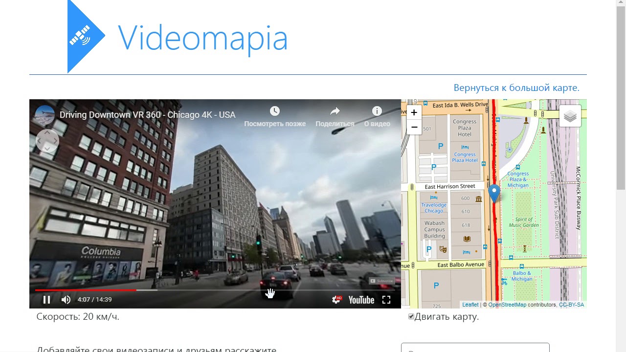 Watch a overview of Videomapia - Sometimes there are 360 videos, but usually they are dashcams.
On the first page of the site there is a map on which the red lines show the places where the video was filmed. To search for videos, left-click on the map where the red lines are. Previews of found videos appear on the left. There are also links to watching videos.
- Mapillary seems to be Losing It’s Marbles
-
Git Along, Little Dogies
(speeding up renaming files) - I’m losing my Marbles because of Mapillary
- A new record for Mapillary - 62 blurs on a street sign
The picture below was shot on 15 July 2016 on the corner of Carnarvon Grove & Cavendish Road within the parish of Carlton, Nottingham. Like so many other Nottingham street signs it has been vandalised, in this case quite recently, and the vandalism was performed by Mapillary.

I suspect that Mapillary may have jumped the shark. They are certainly losing my affections. After about 10 12-hour days spent editing a few thousand blurs within 69 sets of photographs, yet without any action on their part, I recently sent them an email:
From: Me
Subject: Re: [Mapillary] Re: Re: [Mapillary] Blur editor ineffective
To: Mapillary <support@mapillary.com>
More problems with the Blur Editor window:
This store has been permanently CLOSED since 2017
Posted by Nathaniel Young on 15 February 2019 in English.
Decided to cycle to the University via the North-South Track, the Springs, the Pipeline Track and the Water Works yesterday (15th of February, 2019). Discovered the “moderate” in terms of difficulty is relative. Used GNSS to track the paths and to correct OSM for MTBing.
- Mapillary seems to be Losing It’s Marbles
- Git Along, Little Dogies
(speeding up renaming files) - I’m losing my Marbles because of Mapillary
- A new record for Mapillary - 62 blurs on a street sign
 (Be warned that today’s Diary is most whimsical)
(PS That picture above is linked to a “Family singalong”)
There is a house on Kenrick Road, Porchester Gardens, Nottingham that is called “Fool’s Jig”, and there is a link in the map to a picture lodged within Mapillary of that House-Name (below).

Dear all,
Today, v4.20.0 of the OpenStreetMap Carto stylesheet (the default stylesheet on the OSM website) has been released. Once changes are deployed on the openstreetmap.org it will take couple of days before all tiles show the new rendering.
Changes include
- Progressive lightening major buildings fill and outline (#3659)
- Adding rendering for aboriginal areas (#3521)
- Dropping rendering of leisure=common (#3619)
- Adding missing oneway arrows for tracks and paths (#3614)
- Changing way_pixels limit to 750 for protected_area boundaries (#3661)
- Adding rendering for ref of track roads (#3654)
- Improving rendering of text labels on admin and nature-reserve borders (#3652)
- Changing way_pixels calculation to use scale_denominator (#3657)
- Fixing layering order for construction=* highway categories (#3646)
- Reducing saturation of pitch outline color (#3658)
- roads-text-ref-low-zoom: remove unused SQL CASE conditions in ORDER BY (#3680)
Thanks to all the contributors for this release, including almccon and Nakaner, new contributors.
For a full list of commits, see https://github.com/gravitystorm/openstreetmap-carto/compare/v4.19.0…v4.20.0
As always, we welcome any bug reports at https://github.com/gravitystorm/openstreetmap-carto/issues
Posted by sniperowl140 on 13 February 2019 in English.

We have been given an assignment to talk to any barangay official where we live that we may be able to talk about the Disaster Preparation status of our barangay. Last Saturday I have talked with the barangay secretary about it and learned that we only have a few evacuation site/area there. The evacuation areas are: The San Perfecto Elementary School, the Roosevelt Memorial High School and the two courts there. The most flood prone and fire prone area in our barangay is along the F. Manalo St.
I have realized that although we are prepared for the flood and fire disaster, for we have a fire truck and life boats ready in our barangay, it is still not enough to be fully prepared when that time comes especially when earthquake strikes. Then today we have discussed here at Pup San Juan if would that evacuation area, fire trucks and life boats are enough to help your whole barangay when disaster strikes?. No, because only a part of the population we have will be able to get the help of these evacuation site, literally only a small percent of it can cover with these sites.
So we have learned today that being personally prepared with your family when disaster comes is much more helpful to survive any kind of disaster. knowing where are the evacuation sites in your place and how well you are prepared with the disasters are. It is essential to a family to talk about how are they going to do, be prepared and make a plan when the struggles strikes or disaster strikes. Either with or without them will be able to help you to know what to do because you are prepared. And it would be a great help to our community if you are just prepared instead of just relying to what our government can provide or help.
https://s3.amazonaws.com/files.fieldpapers.org/atlases/g24pjkkz/atlas-g24pjkkz.pdf
Posted by Kirigaya Kazuto on 13 February 2019 in English.
After our gathering of how ready is our family in case of natural phenomenon that having a planning session on our family is important because it shows us how ready our family was incase of natural phenomenon that we might encounter like earthquakes,floods and many more.
We cant prevent it but we can save our love one or anyone lives.
Having a plan in our family is very important because thats how we lessen the damage that can cause of this natural phenomenons or events.
For planning we always just come with the questions like “where do we need to go if one of the member of our household is far from us?”, “what do we need to bring?”, “what do we need to do after the event?”, and “who we can get to?”.
Those are just the simple but it was can save anyone from this or that event.
The possible answers are “We need to go to the nearest evacuation center like basketball court or any open are”, “we need to bring the first aid kit incase of one of us is injured”, “we must do set a place where we can meet each other”, and lastly “look for a relative that might help you”.
In this simple planning it help us lessen damage in our family and in our family status.
What I mean for the family status is that we didnt heard that of the member of our family is gone or "not" might be dead.
Thats why mapping help us where to locate the nearest and the safest way to get to the evacuation center. Mapping helps us all how to manage time and manage our self in case of natural phenomenon. That`s all for now THANK YOU!

Interview
I had ask a Barangay Chairman about the situtation of our area specifically baragay 875, zone 96. The area is in the southern part of Santa Ana, Manila. I had a conversation with her about the disaster plan of our area. My questions were about what is the current situation of the barangay in terms of prevention and preparedness when a certain disaster occur like fire,flooding and earthquakes.
She answered that the status of the barangay is moderately capable of handling a disaster with such programs taking place like the cleaning of canals that will reduce the risk of high flooding in the lower parts of the area. Santa Ana Manila is also known as an area where fire is rarely to happen but there are nearby fire stations near the major roads. Also our area is close to the fire stations of Makati which might help in case of fire. When an earthquake happens the barangay is quite not prepared in what to do and the nearest open area is at the nearby school which has an open field in the centre of it. That school may accommodate people whether people are temporary displaced. She also added that the coordination of other barangays helps in making the area be prepared since our barangay does not have the facilities yet, the unity between others areas with their resources might help.
Awareness
Is Location on my Smartphone going to die? OS updates may well be available, but Vodaphone stopped providing them 0 secs after I bought it.
(boring detail from the Register link above follows)
GPS satellites contain an atomic clock, and the signal that they put out contains a timestamp derived from that clock. The timestamp is an inherent part of the way in which a device Location is calculated from the accumulated GPS signals. However, that Timestamp stores the week number using ten binary bits…
Ten binary bits == 2¹⁰ == 1,024 weeks ≈ 20 years
The first GPS satellite launch was 1978. The first epoch was 6 January 1980 & the first rollover was midnight UTC Sun 22 Aug 1999 & the next will be the first Saturday in April 2019. Yikes!
Extra
If you want to see the timestamp for a JPEG with embedded Location info, then do this (and note: this was done because the time went weird for this set of photos (all 3 timestamps should be the same)):–
$ identify -verbose 2016-10-08_11-27-27.jpg | fgrep 'exif:DateTime'
exif:DateTime: 2016:10:08 10:27:27
exif:DateTimeDigitized: 2016:10:08 10:27:27
exif:DateTimeOriginal: 2016:10:08 21:58:52
Phew! We are all Saved!
I’m indebted to TheSwavu (see Comments) for a link to wired.com detailing how everything went fine (?) on the last time this happened in 1999:–
At 8 p.m. EDT Saturday (21 Aug 1999), the clock was reset to zero
The US Coast Guard said it was unaware of any serious distress calls from boaters related to malfunctioning GPS receivers.
He said fewer than 12 Coast Guard cutters, aircraft, boats, cars, and other auxiliary vessels reported a glitch, however fleeting, when their GPS receivers failed to update automatically. Fixing those short-lived glitches typically required nothing more than powering down a GPS receiver to get re-synchronized with the satellites, McPherson said.
Posted by kin maximus on 12 February 2019 in English.
Last updated on 10 May 2019.
Today, the discussion is all about the preparedness of our baranggay in a calamity that might happen in the future. As I heard from them, their community was prepared as if the disaster will happen soon. They do have interviews with their local officials such as kagawad of their baranggay for some important details about the plans. I believe in our baranggay, they do have plans on disasters but I don’t think that it can respond immediately in all areas in Pinagbuhatan Our baranggay is huge with large number of people not just like in Manila were baranggay’s are small. But it seems that even our community are lack of it, they make sure that all citizens are aware in the calamity. As I remember during my junior high school days, most likely, the school always does an earthquake drills for preparation for the disaster. Ambulance, fire trucks and others cooperate with this drill. The teachers always remind where should we go in case of disaster that might happen and what should we bring always with us such as whistle, flashlight and first aid kit. Also, the local officials conduct some seminars regarding with this situation for parents and students. And for floods, sirens are heard so that everyone alerting in case of evacuation, especially in our area that’s near from the river.
Just finished a few map additions in Eastbourne, after a visit. It very much strikes me now, that OSM is becoming too ‘Americanized’ - I go to add a Car Park, and find it’s now a ‘Parking Lot’. Never learnt that in school! I checked my personal settings and they are still en-UK - but I’m getting ‘Mailbox’ (was Postbox); ‘Rowhouses’ (was Terrace); ‘LawOffice’ (was Solicitor); ‘RealEstate Office’ (where are all the Estate Agents?); ‘Subway’ which is a pedestrian underpass, not a part-underground urban railway; use of ‘Store’ for a small Shop; and more - not to mention the omnipresent ‘Trainstation’ (what ever happened to Railway Stations?) and ‘Mall’ (where are all the shopping centres?). I must admit that the Brits do have a problem with ‘Pavement’ but would agree with the suggestion that ‘SidePath’ is more appropriate than the americanese ‘SideWalk’ as many are now used for cycling. I don’t know who is changing our UK version of OSM to join the trendy adoption of Americanese in UK English but Please can we have our language back?
Sunday I had to go to Mary to open our winter film festival, after which I went down to Yoloten and doubled back on the P-25 highway to Bayramaly, a road not traveled by anyone in the embassy in living memory. On that section of the P-25 we confirmed one gas station I was 99% sure from imagery was indeed a gas station, and we found three more that were not obvious in the imagery. We added other POIs found along the way and I am presently uploading about 10,000 ground-level images to Mapillary.
Of course, the best part of the day was fresh fish for lunch at the Lebap Cafe in Hanhowuz, deep fried in cottonseed oil.
