Diary Entries in English

Recent diary entries

Posted by Anton Khorev on 15 November 2018 in English.

There are problems with level=* tag stemming from the fact that not all mappers agree on what it means. This problem comes up more often in some geographic areas than in others where different floor numbering traditions exist. In this sense it is like name=* tag where certain parts of a name stop looking like parts of a name after being translated into a different language.

So what are exactly the problems with level=*? Some people think that the value of this tag should be whatever floor number that is used in place. You can usually but not always read it off some plaque, floor plan or elevator button. Other people think that the value should be a number such that the first floor at or above the ground level gets number 0, the floor above it gets 1 and so on. Those two different ways of assigning a value could be exactly the same, especially for English-speaking areas where they have a “ground floor” as level=0 and a “first floor” as level=1. If you are from those places, you may not even understand that there’s a problem. If you are from a place like Russia or the US, it’s evident for you that those ways are different. I’ll be using Russia as an example because it’s where I map.

But there should be no debate about the exact definition of level=* tag because we have a wiki where it’s perfectly documented, right? Not quite. First of all, we don’t have one wiki, we have multiple wikis in different languages. Those languages may correspond to areas with different floor numbering traditions, which in turn affects the wiki contents. Again, this is like name=*, where local wiki editors put their preferred spin on what should and what should not be part of a name.

See full entry

The OpenStreetMap project is organized on an international level by the OpenStreetMap Foundation, under British law.

Some companies are paying employees to join, and there are rumors that they give voting instructions.

In recent years, the Board has gradually lost its balance. Over-representation of some areas and groups makes it difficult to maintain a balanced and diversity of government action and raises some conflict of interest issues. Therefore, it is important that all kinds of mappers join in to balance things out.

On December 15 there are board elections, and everyone who was a member before November 15 can vote.

489 ballots were cast during the last election. By way of comparison, in the last few days, 17 employees from a single US company have joined. This might not be anything sinister, but it’s worrying especially shortly before the board election, and getting the largest amount of OSMF members is the best safeguard of balance.

https://join.osmfoundation.org/normal-membership is the form. It costs £15 (about €17 or $20), it takes 4 minutes, it’s important and it’s too late in 24 hours. I am a candidate for the board election, but of course you distribute your votes however you want.

Location: Hollerich, Luxembourg, Canton Luxembourg, Luxembourg
Posted by Richard on 14 November 2018 in English.

Last week there was a small change to the API which means some GPS traces are now returned unordered whereas previously they may have been ordered. This obviously has implications for editors’ GPS display. Potlatch 2 now copes with this by doing some basic proximity testing in an attempt to ‘reorder’ the unordered points, which restores the GPS layer to some degree of sanity.

At the same time, I took the opportunity to fix something that’s been bugging me for months. Historically, Potlatch 2 draws all the features crossing the current viewport, and then removes the sprites when they’re no longer visible. This is fine except when you pan across a 2000km power line, which takes ages to draw as a dotted line at z19, and bogs down Flash’s display performance for evermore. For such large objects, P2 now only draws the on-screen part, which makes it a whole bunch snappier.

I spent some time clarifying the Fox Chase-Newtown branch of the old Reading Company, currently the Fox Chase SEPTA commuter rail branch. It starts at Shady Lane and continues to Country Line Rd. as two separate agreements between SEPTA and Montgomery County. Anticipating a 2019 agreement between SEPTA and the City of Phila. for the section between Rhawn St. and Shady Lane.

Ann and I celebrated the Monday holiday of Veterans Day, November 12, by driving out to Hauz Han about three hours east of Ashgabat, heading north on the P-9, then turning east on it to Mary. I had never been on that route and we collected two gas stations plus took lots of ground-level imagery using Mapillary. I will upload that imagery plus imagery collected on the P-25-to-P1 drive when we next come stateside and have access to high speed internet. I have already uploaded the GPX files Mapillary generates, however, so can tweak the highway itself as needed.

I used MAPS.ME to collect some POIs along the way, including marking some new U-turns on the M37. Turkmen Auto Roads State Concern is putting up guardrails to separate new dual carriageways, so mapping the U-turns is an ongoing effort. Some of the village and farmers association names have changed so I have more editing to do, updating names of municipalities to match the signage. Gulanly is now called Gokhan, for example, renamed in honor of one of the sons of the mythical Oguz Han, progenitor of the Turkic peoples. I tried to capture the signage on Mapillary.

We stopped for lunch at the Lebap Cafe in Hauz Han, to eat fresh fish (grass carp) deep fried in cottonseed oil. If you are in the neighborhood, I recommend the Lebap Cafe!

Location: Altyn asyr District, Ahal Region, Turkmenistan
Posted by mvexel on 12 November 2018 in English.

MapRoulette 3.10 is now available on maproulette.org. Here’s what’s new!

For Mappers

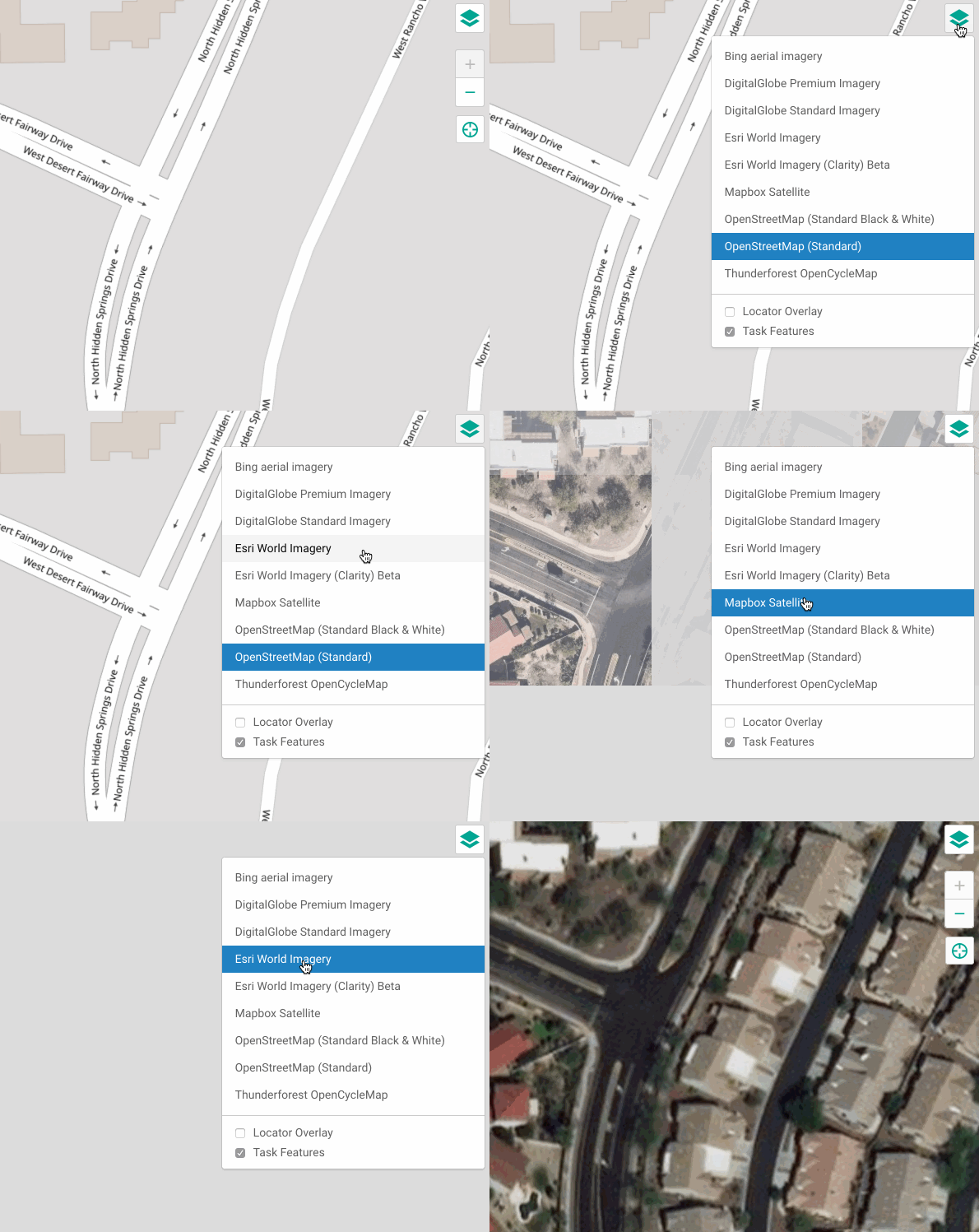
We made changes to the map layer selection. You can select more and more relevant background map layers in MapRoulette. The available layers are retrieved from the OSM Editor Layer Index. For aerial imagery layers, you can also select the Mapbox road overlay.

When browsing for Challenges, you can now sort the results different ways: by age, by popularity and ‘smart’ which also takes into account Featured Challenges and Challenges you saved. The old sorting by name is also still available.

See full entry

Posted by yvecai on 12 November 2018 in English.

I’ve figured out recently that opensnowmap.org base map (topo) renders underground water pipes like plain rivers. It will need a database reload to fix this. Certainly I can correct other glitches at the same time, so have you spotted or can you find something else really wrong with this style? I’m mainly interested in mountainous places, of course, don’t expect fixes in Manhattan subway lines ;-) The style is derived from OSM-bright. Thanks in advance, Yves

Posted by Jeff Underwood on 12 November 2018 in English. Last updated on 19 November 2018.

Although the team has shared the process in depth at various conferences and discussion post and the wiki, we have gotten feedback that we could clear up some of the processes by providing more details. So here it is.

At Facebook, we use our ML (machine learned) data as a starting point but then completely re-edit, fill in the gaps, and correct errors with human editing. Machine learning can do amazing things, but even the best predicted area will always have issues that need a human to fix. An untouched ML file will often have disconnected ways, gaps in the network, road type inconsistencies, and geometry issues. The job of our human editors is to use this ML data as a base and build fully fleshed out, high quality data.

The Machine Learned XML file

See full entry

Posted by tyr_asd on 11 November 2018 in English.

Normally, I blog here more about technical topics, but today I would like to take the opportunity to honor three small parts of the OSM community, who I happened to have the chance to get to know over the years that I’ve been active in mapping. All of these groups deserve a shout-out for their great work they do on OpenStreetMap month after month.

  • The OSM community in Graz (Austria) managed to map their city in great detail and keeps it complete and up to date. It was a pleasure to be a part of the monthly meetups back when I studied there. I remember many fruitful discussions over good food an a nice beer or two. Keep up the good work, guys!
  • Geofabrik is a company from Karlsruhe (Germany) which provides OSM related services since many years, some of which are available for free to the OSM community. Thank you for maintaining your OSM data extract download service, and for hosting your iconic hack weekends. You’re awesome!
  • The disastermappers heidelberg are a group of students of Heidelberg University who regularly organize mapathons and workshops, and try to raise awareness of the benefits OpenStreetMap data towards a wide audience. Don’t stop educating the mappers of tomorrow!

Do you also know groups or individuals that do great work in OSM? Let them know! :)

Posted by apm-wa on 11 November 2018 in English.

Much more of the P-1 national highway in Turkmenistan is now a dual carriageway divided highway, so the last couple of evenings I’ve been updating it based on GPS traces collected and marker tags inserted via MAPS.ME during travel on November 8. It’s done, but there will be more to do over time. Pavers were working, and the right of way of the new parallel lane, long neglected, is back in play on much of the P-1 route. All bridges appear to be up, so it’s now a matter of bulldozing, grading, graveling, and paving.

Special bonus: We found a new grocery store near our house in Ashgabat today.

Location: Ak bugday District, Ahal Region, Turkmenistan
Posted by alexkemp on 10 November 2018 in English.

Hard on the heels of my previous Diary (How to report spam) I’ve discovered spam within a changeset (map edit) for the first time:–

Changeset#6050808957

 addr:city	Hà Nội
 addr:district	Thanh Xuân
 addr:housenumber	25
 description	Video Bài Hát Việt Nam
 email	<redacted>@gmail.com
 name	Ngoc Anh
 phone	<redacted>
 start_date	10/11/2018
 website	https://www.youtube.com/watch?v=<redacted>

Splendid.

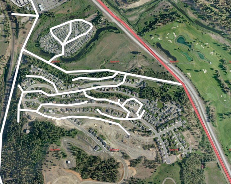
TIGER is the street database from the U.S. Census. An old version of TIGER was used to bootstrap OSM in the U.S. back in 2008. We have come a long way since then (see image below) and OSM is now much better than TIGER in most places.

Image from osm.wiki/TIGER_fixup

New versions of TIGER are released every year and they are still useful. Local governments update it with new roads and street names. If you compare new TIGER data with what’s in OSM, you get useful information about where OSM may need improving. If you edit in iD, you get visual cues when roads are missing:

See full entry

Posted by Kevin Haynes on 9 November 2018 in English.

I am pleased to announce that in celebration of Geography Awareness week AND International Education week. The Western Michigan University geography department has organized a mapathon.

Where: Western Michigan University Classroom E in the Swain Education Library

When: Wednesday, Nov. 14 from 5-10 p.m.

Why: Because points, lines, and polygons will change the world!

Food provided by the Geography Department.

If you are a WMU student, this event is part of the WMU Global Engagement Signature Program.
Link: https://wmich.campuslabs.com/engage/event/2816689 for more information

Contact me if you have any questions.

Location: Kalamazoo, Kalamazoo County, Michigan, United States
Posted by apm-wa on 8 November 2018 in English.

Just got back from 2-1/2 days on the road, during which inter alia I traversed the P-25 and part of the P-21 national highways in Turkmenistan. I collected roughly 38,000 ground-level images with Mapillary, but will delete some before uploading due to quality issues. Got good GPS traces, however. Tried using MAPS.ME to collect POIs but there are issues due to its limited universe of categories. I ended up using “Attraction” as a default tag just to mark POIs geographically (including U-turns on newly divided highways and such), and now am plowing through them at my desktop computer to correct them to something resembling reality and OSM guidelines. I hope this will not garner too much opprobrium from the OSM community. I’m cleaning up the mess I’ve created as quickly as I can, but I did want to collect data as I was traveling!

Posted by seav on 8 November 2018 in English.

Today, November 8, is the fifth anniversary of Typhoon Haiyan, known locally as Typhoon Yolanda, making landfall in the Philippines. This devastating typhoon, which broke the record for being the strongest landfalling tropical cyclone in history, had a lasting impact on the country and its effects are still affecting Filipinos to this day.

For the OSM Philippines community in particular, Typhoon Haiyan radically transformed what it meant to volunteer our time, effort, and resources to map and provide freely accessible geographic data for the country.

Before, the local OSM community was a pretty small group of hobbyist mappers who enjoyed going outside to map and share information about the places we live, work, and play in. But Haiyan showed us that the work we do in mapping the Philippines can sometimes mean the difference between life and death. Past typhoons and storms like Ketsana (Ondoy), Washi (Sendong), Bopha (Pablo), and the 2013 Bohol earthquake had shown the potential of OSM in applications related to humanitarian efforts and disaster resilience, but Haiyan has thrown that into a painfully clear perspective.

See full entry

Posted by Reinhart Previano on 7 November 2018 in English. Last updated on 8 November 2018.

Major Edits in Resorts World Genting, Malaysia

Today I am going to announce a large change to the OpenStreetMap database. What is it? The complete removal of the old Genting Highlands Theme Park assets.

If you are using Bing, MapBox, or DigitalGlobe (Premium) satellite imagery, you are still seeing the old face of Genting theme park.

Image 1

However, if you use the standard DigitalGlobe imagery, you will see that everything has changed since 2015, the last time I visited this place.

See full entry

Location: Gohtong Jaya, Genting Highlands, Bentong, Pahang, 69000, Malaysia
Posted by mvexel on 6 November 2018 in English.

In this post, part of the MapRoulette Insider series, I will show you how to create a MapRoulette Challenge yourself.

The first thing you need is a Challenge idea. Good challenges have tasks that:

  • Are easy to solve (typically less than one minute)
  • Do not require local knowledge
  • Involve only one or two OSM objects

My example challenge meets those criteria. I ask mappers to review motorway_junction nodes in the United States that have name tags. This is uncommon in the U.S. Often mappers will add a name tag that has the destination information on it, so the information renders on the map:

This Overpass query selects all these nodes.

area[name="United States of America"]->.a; node["highway"="motorway_junction"]["name"](area.a); out meta;

See full entry