Diary Entries in English

Recent diary entries

Posted by qeef on 1 January 2025 in English. Last updated on 20 July 2025.

This is the developer’s diary concerning the fifth year of the damn project – the project that helps mappers by dividing a big area into smaller planar shapes that people can map together.

The damn project is currently used by few mappers as a tool for tracking personal mapping. (Does it make it a competitor to the SimpleTaskManager?)

In 2024, we had some problems:

  • We had performance issues when working with more than 300 000 squares in a single area; we solved these issues by pagination and forbidding creation of areas with more than 10 000 squares.

  • The damn JavaScript clients confuse mappers and we need to be serious about it; we will address this issue in 2025, but it’s not yet decided how. We are open to ideas!

2024 did not bring much to the damn project, though there are some highlights:

  • Probably no suprise that we moved to OAuth2. The amount of work is -21 lines of code. We welcome such changes.

  • I wrote Unofficial design documents for HOT Tasking Manager.

    The original intent of the damn project was to show that HOT Tasking Manager (HOT TM) can be done better. To help HOT TM developers, last year I wrote Unofficial design documents for HOT Tasking Manager. There is (obviously) more reasoning and comparison than in the damn server dev doc, but I don’t think it will help anyway. There is too much work and I saw the HOT TM source code. It’s unmaintainable, in my opinion.

  • We implemented enforce divide to squares function when creating new area.

    If the (area’s GeoJSON)’s FeatureCollection has member 'name' then divide to squares function is NOT used. In such a case it’s expected you already divided the area – this is for compatibility reasons with MapSwipe. enforce divide to squares overrides this behavior, enforcing the division of the area to squares even if the 'name' member is present in the GeoJSON’s FeatureCollection of the area.

And finally, the plan for 2025 – there are two main things:

See full entry

Posted by ChofOjeda on 31 December 2024 in English. Last updated on 18 January 2025.

2024…I’ve learned a lot of things…

  • I mapped some trees at my university.
  • I love nature! So I helped @Ludway map his school with some kids. There, I practiced my knowledge of trees and species. I learned how to measure a tree! Also, I learned about some botanical things.
  • I mapped my neighborhood and learned how to map buildings, shops, paths, etc.
  • Now I’m envolved in YouthMappers, and I’m very proud of that.
  • I met amazing people like @AngocA, @JuanMelo and @se_bras , who have taught me many things about the GIS and how develop proyects.

This was a great year, I hope next year will be better!! :)

Location: UPZs de Bogotá, Localidad Kennedy, Bogota, Bogota, Capital District, RAP (Especial) Central, Colombia

It has been a productive year for me on osm yet I am still reaching for a more comprehensive map of both Anchorage and greater Alaska.

Mapping Natural Features

This year I continued to map large swathes of natural features in Alaska. It is still very much an open canvas to add features and without even a goal in mind it has been easy and quick to add large areas in small osm breaks throughout the day in 2024. Corollary studies published this year on the prevalence of Alzheimer’s based on occupation points to reduces occurrences with jobs requiring constant active direction finding (ambulance drivers and taxi drivers in particular). It’s been hypothesized this is from activation or stimulation of the hippocampus. That’s something I imagine I can trigger to some degree with mapping that I wouldn’t get from my typical computer work. I feel as though osm is keeping my brain sharp at least.

My First 2025 Goal

See full entry

Location: Anchorage, Alaska, United States

Well over a year ago I extracted all the amenity=pub objects for Great Britain. Nearly 860 keys are used across all the elements. I’ve spent some time delving into these keys, trying to classify them, and hopefully learn a bit about two things: the kinds of information people want to know about pubs; and why synonyms exist for certain keys and tags. I’ve been prompted by SomeoneElse’s list of building tags.

The Top House, Lizard - geograph.org.uk - 903767 A pub which I recently edited on OSM adding real_fire=yes.

See full entry

Location: Landewednack, Cornwall, England, United Kingdom

📅 Date: 30-1 November 2024 🌍 Location: Cox’s Bazar, Bangladesh 🏷️ Hashtags: https://www.facebook.com/hashtag/sotm2024?__s_fcid=6811183504691807194&__s_fbid=1115079362841034 #OMGuru #YouthMappers #EasternUniversity #OSM #MappingForChange #GeospatialRevolution

🌍 A Journey of KNNOrganization, Collaborate, and CONNECTION Besides being a conference the State of the Map Asia 2024 in Cox’s Bazar was an experience that made me feel I am an empowered and global mapper. Held from November 30th to December 1st, 2024, this event truly captured the essence of its theme: “Unite, Inspire, Innovate.” And the best part? I was awarded the Certificate of Participation upon my active participation in this amazing campaign!

🔥 Day 1: 𝐈𝐧𝐬𝐢𝐠𝐡𝐭 𝐃𝐢𝐬𝐜𝐮𝐬𝐬 𝐚𝐧𝐝 𝐊𝐞𝐲 ℚ𝐮𝐞𝐬𝐭𝐢𝐨𝐤 The first day of the map conference State of the Map Asia2024 started with a brilliant and inspiring keynote by Said Turksever from Mapillary&@Meta. His insights into the future of mapping technologies were nothing short of captivating, especially when he raised these two crucial questions: 1) Does Mapillary have certain regulations, or limitations on what and where users can record via their application? 2) What are the further objectives of the Mapillary platform and what updates are further expected from it? These questions raised debates regarding the ethical issues within and the future possibilities of such platforms as Mapillary, thus promising a highly stimulating tone for the whole conference.

See full entry

Location: Navy Co-operative Housing, Akran, Savar Subdistrict, Dhaka District, Dhaka Division, 1345, Bangladesh
Posted by LonMcGregor on 28 December 2024 in English.

A few years ago I started working to make my town, Glenrothes, more visible on the Open Street Map. Mostly it was just roads and land use imported from public data, though a few people had added in some housing areas, addresses, and point of interest. I have steadily been adding all the missing buildings, shops, addresses, other missing POIs and cleaning up major land use blocks.

It is far from perfect, but things are in a much better state than they were a few years ago. But there are still a few areas where data needs to be added. If possible, it would be nice to address these in the coming year:

  1. Finish adding the remaining missing addresses - There are a lot of neighbourhoods still missing address data. The UK’s PAF still hasn’t been released under open license, so these will need to be surveyed and added manually. In clockwise order: Collydean, Pitcairn, Balfarg, Cadham, Markinch, Thornton, Stenton, Caskieberran, Stenton, and Leslie. I want to be accurate though, and the layouts of houses in same areas can be difficult to navigate, so it may take some time.
  2. More details for POIs like shop opening hours - Locations on the OSM can have additional metadata like contact details, opening hours, whether they are disabled accessible, and things like types of menu for restaurants. Some of this info is made available on websites, some of it may need direct surveying.
  3. There are lots of construction areas around town that will need to be surveyed when they are complete. New buildings and POIs to be added. The town park is also being upgraded and when it is finished next year there may be lots of changes to update, like new paths and play areas. Some of these changes have already been updated.

See full entry

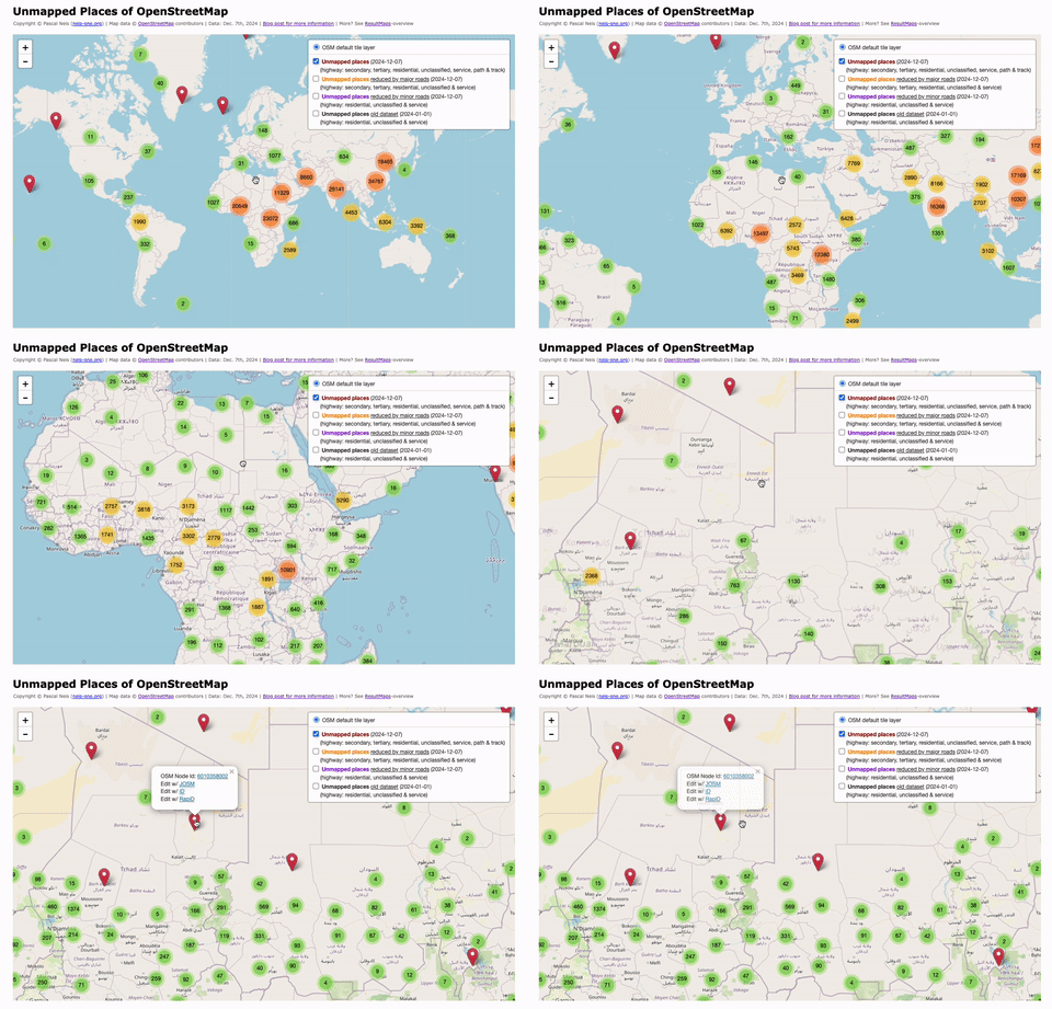
In 2010, I first conducted a study which identified regions (places) in the OpenStreetMap (OSM) project in Germany that still had potential for more detailed mapping. Later, in 2016, this analysis was repeated and extended to the entire world. I have since regularly carried out these studies and published the results. The algorithm and some more details are documented in an earlier blog post of mine.

For the year 2024, I have recalculated this analysis and published the results on my website: “Unmapped Places of OpenStreetMap”. For the study, the OSM Planet File in PBF format from Dec. 7th was used. It can be downloaded here. https://resultmaps.neis-one.org/unmapped

See full entry

Location: 0.000, 0.000
Posted by bhousel on 23 December 2024 in English.

Rapid v2.5 released today!

Happy Festivus from the Rapid Team! Today we released v2.5 of the Rapid editor for OpenStreetMap just in time for the “Feats of Strength” 💪

Here’s 4 new features that we’re really proud of!… lets rumble

🧚‍♂️ Pixi v8 Upgrade!

We upgraded Rapid’s render to use the latest version of PixiJS game engine. This version gives Rapid a welcome performance boost - if you’ve aired any grievances about Rapid being laggy, the new Rapid should perform much better for you!

See full entry

Ah, State of the Map! The pinnacle annual gathering of our own kind, where we, the OSM community, come together to exchange insights, celebrate achievements, and explore the latest advancements in technology.

How was my experience overall, you may ask? Eight days of relentless effort—rushing between offices to complete my passport and visa, and spending countless hours traveling on various modes of transport—just to attend a weekend-long conference. Was it worth it? Absolutely, without a doubt! In fact, I’d gladly go through it all again in a heartbeat.

This experience was nothing short of incredible. It was a joy and privilege to finally meet Mikko Tamura, Honey Fombuena, Harry Mahardhika, Nama Raj Budhathoki from HOT, and so many other inspiring individuals from the Bangladesh and Nepal OSM communities, as well as the vibrant YouthMappers network. Their boundless energy, unwavering passion for improving OpenStreetMap (OSM), and commitment to encouraging mass adoption left a profound impression on me.

Connecting with them wasn’t just about OSM; it was about engaging with a group of extraordinary people whose enthusiasm and vision resonate deeply. Their drive to create positive change is quite something, and I am more motivated than ever to channel that same spirit into my own initiatives in the near future.

The weekend wasn’t just a conference—it was a gathering of minds, a celebration of shared purpose, and an unforgettable opportunity to be part of a community that genuinely inspires. I am immensely grateful for every moment of it.

Location: Hotel Motel Zone, Cox's Bazar Sadar Upazila, Cox's Bazar District, Chattogram Division, 4758, Bangladesh

I’ve been mapping in Alaska for quite some time now, with a specific interest in mapping national parks, forests, and other protected areas. It has become apparent to me that much of the state, with the exception of southeast Alaska, lacks sufficient hydrographic data in the map. I’ve been working on chipping away at this problem intermittently, adding lakes and named waterways. However, given the size of interior Alaska’s national and state parks, attempting large scale additions by hand would be prohibitively time consuming.

I’ve gained a good deal of familiarity over the years with the software needed to perform an import of USGS National Hydrographic Dataset data to fill this gap. My current idea is to download the needed NHD dataset from the USGS website, convert it to .shp in QGIS, delete all tags from the data and split it to smaller files. I would then load the raw shapes into JOSM using the opendata plugin and add tags manually. I would avoid conflicts with existing data by loading it into the editor prior to loading the .shp, thus allowing me to integrate the data more seamlessly.

I am aware that it is customary to receive community buy in before beginning an import project. I’ve run into some confusion on this as Alaska has a very small OSM community that is not well established. I could contact a few mappers individually, but I am not sure if that alone would satisfy the need for community buy in.

I’m curious as to what input people have on this

I have not participated in so many State of the Map conferences, only in two LATAM conferences, the first one being Sao Paulo in 2016, historical for me since the Geochicas were founded on this occasion and the following year in 2017 in Lima. I also participated in a Global conference in Milan (2018).

These conferences have seemed fundamental to me because of the links they generate, strengthen and activate. The OSM universe has a remote reality where in a somewhat miraculous way very strong human bonds of friendship, collaboration, emulation, creation, where it is possible to generate governance issues, where it is possible to build agendas and develop them. However, the face-to-face coexistence brings to this an additional unfailing strength: the friends we make at the State of the Map conferences remain forever. In addition, obviously, we discover themes, ways of impacting reality thanks to collaborative mapping, we update ourselves, we connect with people, companies, institutions and we all grow together.

That powerful sub-communities like Geochicas have emerged stimulated by one of these conferences is telling, Geochicas now being recognized globally for the actions and leadership it builds, and for what it manages to bring to the open technology communities of the geospatial world.

By connecting with people at these conferences, we also build bridges between national and regional communities allowing individuals to bring valuable knowledge in other contexts. I think of my connection with Jorge PB from Cuba, from SOTM Sao Paulo, which has led me to participate in other conferences in Cuba contributing there, I hope, some grain of sand.

See full entry

Location: Tlatelolco, Mexico City, Cuauhtémoc, Mexico City, 06900, Mexico
O capítulo YouthMappers UFRJ relembra suas atividades desenvolvidas em 2024 e agradece aos seus parceiros e colaboradores

Retrospective of the YouthMappers UFRJ chapter activities in 2024 and thanks to our partners and collaborators

   English below ;)
Aqui estão apenas alguns dos destaques…

Nosso capítulo completou 1 ano de existência em maio de 2024 e continuamos a pleno vapor, com atividades abertas de mapeamento e de capacitação em OpenStreetMap. Neste ano, incorporamos o uMap no curso básico de OSM, a fim de oferecer mais recursos para quem nos acompanha. Somente em 2024, foram realizadas 17 oficinas e emitidos 700 certificados.

O nosso projeto é registrado como uma ação de extensão na Universidade Federal do Rio de Janeiro - UFRJ (Brasil) e conta com a coordenação técnica do Instituto Virtual para o Desenvolvimento Sustentável - IVIDES.org e dos laboratórios Espaço e GeoCart da UFRJ, além das parcerias externas com demais laboratórios do estado do RJ e demais grupos do HUB YouthMappers Rio de Janeiro.


Venha fazer parte desta história! Conheça mais sobre esta iniciativa e veja a galeria de memórias:
https://ivides.org/youthmappers-ufrj
Agradecemos aos alunos e às alunas, aos professores e às professoras e demais profissionais e colegas, que têm se dedicado ao mapeamento colaborativo.

Estimamos boas festas e feliz 2025! 🌎


See full entry

Posted by Md Abir Al Hasan Nafis on 18 December 2024 in English. Last updated on 2 May 2025.

Cox's Bazar

From the day I heard about the program, I was eager to participate in this international conference in my homeland. The venue, Cox’s Bazar, was another triggering factor of enthusiasm for me. Moreover, I didn’t want to miss the opportunity to participate in a State of the Map Asia conference.

Though I come from a coastal area of Bangladesh, I have never been to the Cox’s Bazar. So. the excitement to journey with my fellow chapter members was beyond description. Though I attended only one day of the conference, the day was full of gaining knowledge and experience and making new connections. Many types of people were at the conference, ranging from students to experts and specialists in different sectors.

See full entry

The Proud Moment as a Bangladeshi

My excitement was extremely high since I had come to know that this year’s State of the Map Asia would take place in the beautiful setting of Cox’s Bazar in Bangladesh for the very first time. SotM Asia 2024 had let us acquaint the people from all over Asia with our country’s culture, heritage, natural beauty, and the tradition of hospitality. The co-events – State of the Map Bangladesh, YouthMappers Bangladesh Summit, HOT Open Summit – surely added extra colours to the main event. I was eager to witness this proud moment being present at the conference doing any sort of adjustments needed to my existing schedule.

The Uncertainty & Risks

As my final exams coincided with the event, my participation became uncertain. But as I mentioned before, my willingness to make adjustments to my schedule and comfort made my participation happen somehow. As a result, I could ensure my presence only on the second day of the event – 1 December 2024. I started my journey from Dhaka on 30 November night as I had an exam on that day and reached Cox’s Bazar very early next morning. Then, I attended the conference for the whole day and again left for Dhaka in the evening of the same day. Upon reaching Dhaka on 2 December morning, I again sat for another exam. That is how my trip was designed with so much risks as I was not ready to miss this historic event!

All the Hassle Was Worth It

See full entry