 OpenStreetMap

64 NPC Area B Street, Talipapa, Barangay 164, Caloocan, 1400 Metro Manila
Diary Entries in English
Recent diary entries

For years, an issue with Kurdish language, Arabic script, and OpenStreetMap tiles has been on my radar. In 2023 I got OSM to update Noto fonts on the tile server, but Google has moved their latest changes to individual repos.
I’m continuing to workshop a PR for that.. but in the meantime, I thought to check if OSM needs more of the language-specific Noto fonts. Back in spring 2019 I did a mini survey of where Unicode blocks were used around the OSM world.
Today I added Python scripts to check Planet PBF files (specifically name and alt_name tags on nodes) and find usage across Unicode blocks.
There are names with Latin alphabet and frequently associated characters (superscripts and subscripts, dingbats, diacritics, IPA, half-width, old italic, runic, spacing modifiers, punctuation, emoticons/emoji, and symbols from math, music, currency, and maps).
-
Africa has: TIFINAGH, ARABIC (supplements and presentation forms), CYRILLIC, ETHIOPIC, NKO, HEBREW, CJK, HANGUL, and GREEK.
-
Asia has: CYRILLIC, GREEK, HEBREW, ARABIC, SYRIAC, COPTIC, ETHIOPIC, BALINESE, JAVANESE, CJK + YI + BOPOMOFO + KANGXI, HANGUL, MONGOLIAN, TIBETAN, THAI, MYANMAR, LAO, KHMER, ARMENIAN, GEORGIAN, THAANA, SINHALA, TAMIL, ORIYA, BENGALI, GURMUKHI, GUJARATI, DEVANAGARI, KANNADA, MALAYALAM, OL_CHIKI, and TELUGU.
For the Americas, OSM already includes fonts for Cherokee and Canadian Aboriginal Symbols.
Those two scripts and OGHAM, TAGBANWA, and BAMUM were misused in Asia. The instance of TAGALOG script was a little uncertain. I removed an Apple logo because it’s from the Private Use Area.
The current font download script is pretty good, and includes additional fonts (Adlam and Tai Viet) which aren’t actively used.

so the beach town is seeing growth again, after the primary developers went bust in 2007/8. A large amount of blank land between the shops and the harbour has been cleared, and given asphalt roads, concrete footpaths, and brackish ponds for the mosquitoes to grow in! I hope the new holiday home owners like mosquitoes!
My GPS accuracy is not great and my note taking while walking is worse; but I’ve drawn some new ways on the new footpaths; and verified some of the existing paths from Kenwood Drive to Waimarie Ave are still approximately where my GPS says they are. Good fun.
Need to go back with a laptop next summer to add/tweak more. Hopefully LINZ has updated by then to provide even better coverage

The State of the Map Asia 2024 conference wasn’t held in a main travelers’ hub like Thailand but rather chose a much, not that well-known country Bangladesh, and its previously unsettled political situation, which ended with the Prime Minster fleeing to India. Summarizing all these factors might discourage most people from visiting this country, ended up most of the attendees are domestic, and plus someone like me who is a foreigner is lucky enough to obtain a VISA to pay a visit.
Bangladesh is a young country, during the conference we saw many attendees were students, who might help those international aid projects to gather map data. We can see teachers bring their students to attend the conference. And there are also various student clubs, like all Youthmappers in Bangladesh, publishing their project results. One day we might see when the country is prosperous, and students grown up, there is a chance that they will map shops and buildings in the city where they live.
I want to write something about the general participant situation here in the Asia Pacific area. In developed countries like Taiwan, there are individuals who launch interest groups to map specific map features or netizens with enough motive to contribute to OpenStreetMap project. There are other countries that rely on aid projects to map local map data, and sometimes there are sone who will map modern map features. I have heard a talk about solar pannels in Dahka.
The State of the Map Asia splits its session into quite strange 10-minute parts. I accidentally submitted two talks, and did not get rejected. I had to give a talk on the first and second day, one I introduced the community in Taiwan, and the other day I introduced some interesting projects hosted by individual mappers.
Posted by spwoodcock on 14 January 2025 in English.
Last updated on 15 January 2025.

See pt1 of this series here.
See pt2 of this series here.
See pt3 of this series here.
How Does This Relate To OSM Again?
If you have been following the articles listed above, you will know the Field Mapping Tasking Manager (FMTM) is a tool developed by HOTOSM to improve the quality of field verified data associated with geometries.
In the OSM world, this means adding and improving tags for OSM geometries.
A key element of this work flow is conflation of newly collected data with existing data in OSM. Some preliminary work was done on this, but for now the team decided to pivot and focus entirely on improving the usability of FMTM from the perspective of mappers.
The conflation work will be continued further down the line.
Currently, Rob Savoye is also continuing some work in parallel for conflation of roads in the USA, with OSMUS’s osm-merge project.
The roadmap for FMTM can be found here.
Easier Field Mapping
Since release 2024.5.0, we have be focusing on what we have dubbed the ‘Mapper Frontend’.
Our primary goals:
-
Mapping should be as intuitive as possible for users, requiring minimal training or existing knowledge (with prompts).
-
The application should be fast and responsive, tailored to field mapping needs.
-
Data should load real-time, significantly improving the collaborative team experience. Joe wants to know where Jim is mapping currently, to avoid overlap.
-
A secondary goal is the potential to package it up in a mobile app wrapper, allowing for easy distribution via mobile app stores.

Had to move the summit as it was in a random place. It’s really cool up there.
Youth Mappers University of Nairobi chapter

Hey hey. We at the Yerevan Tree Map project were pulling to our database new nodes tagged as natural=tree for a while now, without actually pushing changes back. Now we are starting to do so. The OSM API is not quite straightforward, so we’re learning on the go. We have some 4k plus trees to push, we’ll be adding them in small batches. Later we’ll start pushing updates to existing tree nodes (e.g. when someone measures the tree or updates its state).
Posted by SeverinGeo on 9 January 2025 in English.

(English below, thanks to Deepl.com)
Ce post a été initialement publié ici.
Des données OSM en anglais, mais aussi en français, accessibles dans l’IFL pour les pays francophones du Sud
Des données OSM téléchargeables avec des attributs dans une langue autre que l’anglais, non pas avec un service web, mais une plateforme dédiée au partage de données et métadonnées géographiques, où l’on peut comprendre, voir, interroger, filtrer avant de télécharger : c’est ce que permet cette approche ETL (pour Extract, Transform, Load, soit en français « Extraction, Transformation et Chargement ») dans l’Infrastructure de Données Spatiales des Libres Géographes. Dans ce billet, je reviens sur le contexte et l’historique de ce projet personnel mené sur mon temps libre, avant d’expliquer l’approche technique mise en œuvre et, évidemment, comment accéder à ces données.
Le contexte : sortir du « english fits for all »
Si l’anglais domine l’écosystème OSM et reste la langue de référence du projet, plusieurs initiatives permettent aux non-anglophones de participer au projet et d’en bénéficier : un forum multilingue, la traduction du wiki et de certaines plateformes d’auto-apprentissage, des interfaces utilisateur traduites pour les applications et les éditeurs, y compris les préréglages d’étiquettes OSM.
Mais quelle que soit la technologie ou le service utilisé, les données OSM brutes, une fois téléchargées, restent exclusivement en anglais, et toute recherche ou filtrage des données OSM dans un logiciel SIG ne peut se faire que dans cette langue.
Ayant beaucoup formé à l’utilisation des données OSM en géomatique (notamment QGIS) depuis 2011, j’ai été vite confronté aux difficultés qu’ont pas mal de francophones non anglophones à exploiter les attributs des données OSM. Difficultés d’autant plus frustrantes, dans le cas des pays du Sud, qu’il s’agissait souvent des premières données détaillées disponibles sur leur territoire. Une barrière se levait, mais une autre lui succédait.
Posted by Josh Glenn (xuid0) on 8 January 2025 in English.
I just discovered https://github.com/openstreetmap/tile-attribution And it seems like a great way to get involved with openstreetmap via GitHub - It doesn’t require any coding ability, one would need an active GitHub acount to add an issue to the issue tracker but basically find a site using your favourite search engines (lets say https//ddg.gg as an example).
Check any sites who are not providing attribution to openstreetmap when using openstreetmap and report the full hostname of website to the issue tracker :-)
What can we all share to people on social media we use to promote friends & family to support OpenStreetMap’s work?
Have a great day! Josh G of Australia.

HIII!!! happy new year! i’ve decided to try an maintain a editing streak for the entirety of 2025 and it’s going pretty well (at time of writing i’ve edited daily since december 25th of 2024)! nothing much aside from that i just try to use streetcomplete when bored lol

Starting the new year with milestone achievements! In this 22nd development update, we’re excited to present comprehensive mobile support improvements across OpenStreetMap-NG. We’ve also reached critical development milestones that put us on the final stretch toward public beta testing.
🔖 You can read other development diaries here:
osm.org/user/NorthCrab/diary/
⭐ This project is open-source — join us today:
https://github.com/openstreetmap-ng/openstreetmap-ng
🛈 This initiative is not affiliated with the OpenStreetMap Foundation.
Video Summary
This week’s video demonstration focuses primarily on our mobile interface improvements. Through practical examples and side-by-side comparisons, I showcase how OpenStreetMap-NG elevates the mobile experience.
⬇ Click the image below to play

4th Jan 2025 and 10 Million, nodes that is, I’ve set, dragged, deleted as at yesterday and the 2 days downtime broke the 1500+ days series of uninterrupted mapping. Here’s to the next.
April 1, 25 , really, and we’re on 11 Million, 3 months near exactly or 11,111 nodes a day, keeping me from the streets away.
Sept 12, 2025, a slow one with six zeros added to get to 12,004,134 exact. It’s a still summer and sunny so the pushbike will be getting more attention today.
Dec. 12, 2025, ‘back on track’, one more million nodes in 3 months exact, only 13,011,800 according to the HDYC tracker.
Feb 4, 2025, reached 2000 mapping days and a coowl 1 million nodes added to OSM in 60 days per the HDYC site., 14 Million cum is up somewhere around the 10-12th,.. that figures \o/.

As time passes I am delving further into the discovery that I outlined here, and contextualised a little more here and all relating to the Fingal task set up by myself and the osm community three years ago.
In quantum of the problem there are new data available from the Heigit counting service. This shows that as the validation continued up to the 18th December 2024 when the task was a year old an additional 14 thousand missing buildings were added.

Looking further into this missing building set it is distributed as follows by building tags:
*building=shed up 3700
*building=garage up 1800
*building=farm_auxiliary up 200
*building=service up 58
*building=ruins up 56
There is also some re-tagging of building objects from the building=yes tag, which mappers were requested to attempt to do.

Since yesterday, we’ve updated our Map of Mithraea using OpenStreetMap and Leaflet – and we’re quite pleased with the result!
If you’re interested in archaeology, ancient Rome, or Indo-European traditions, we invite you to explore it here: https://www.mithraeum.eu/tabula
Vale, The New Mithraeum
Posted by Calvin Menttor on 3 January 2025 in English.


On the 22nd and 23rd of November 2024, I visited the Ho Technical University (HTU) YouthMappers chapter for an exciting two-day program sponsored by OSM Ghana. These two days were not just about mapping but about igniting passion, fostering collaboration, and sharing stories that inspire.
Day One: Presentations and Knowledge Sharing

I’ve deleted OSM node 151352138 which was place=hamlet name=Dominion within the city of Longmont, CO.
It looks like this node was (automatically?) added to OSM based on USGS GNIS feature id 178314. This GNIS feature 178314 includes the following, my emphasis
- Class: Populated Place
- Feature code: Unincorporated Place
- Description: railroad siding
- Entry Date: October 13, 1978
I’ve lived in Longmont since 2008, and I’ve never seen or heard anyone refer to this location or area as “Dominion”. This GNIS “railroad siding” feature should never have been added to OSM as a place=hamlet. I checked current aerial imagery, and while there is a BNSF railway line nearby, there is definitely (no longer?) a siding near this location.
So in changeset 160974302 I’ve deleted OSM node 151352138 which was place=hamlet name=Dominion
Earlier today I OSM-stumbled upon a stele marking the western front line of the First World War in Belgium and France. In Dutch we apparently call them demarcatiepalen, a term which I find amusingly technical sounding. In French they’re often called les bornes Vauthier, named after the veteran who took the initiative of erecting them. Carved from pink granite, they stand about a metre tall. There’s a whole line of them, but I noticed that they could use a lot of work, so that became my project for this evening.
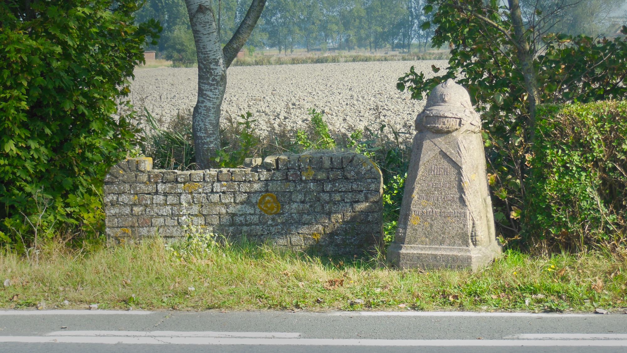
After a few hours’ work (including some distraction due to nearby unmapped stables), the 19 extant Belgian steles have all been found, added and homogenised in OSM and referenced to the database of Onroerend Erfgoed, the heritage agency of the Flemish government.

This last 5 years I have been faced with a terrifyingly real and all consuming gang stalking problem (concept which I didn’t even fully believe in until at the grips of it myself), bringing with it cognitive dissonance, dissociation and confusion through gas-lighting, bullying, financial and emotional abuse by those who are supposed to be closest to me.
it feels like I have lost all sense of footing; like solid ground could very well turn out to have been ocean this whole time and it would not be all that shocking.
My participation in this project is an attempt to help me reconnect with myself and my surroundings
By deliberately noticing everything it encompasses, and by thoroughly researching each of it’s composing elements to be able to represent them with as much fidelity as possible, I hope to regain some sense of direction and purpose and find refuge from stagnancy, isolation and depression.
Hi, my name is Joh,
and I will stand strong and make best of this, and every situation.
I shall bend not break,
I shall be,
Because I have as much right to do so as everyone else.