Diary Entries in English

Recent diary entries

Posted by mmd on 7 January 2017 in English. Last updated on 10 January 2017.

Emojis are only a fingertip away on your iPhone
 it was only a matter of time until they show up on OSM as well. The following query finds all those emojis - worldwide: http://overpass-turbo.eu/s/l6r

Thanks to tyr_asd for the MapCSS enhanced version below

A bit more serious: how about searching for mixed language names like name=Vinh-Loi Asien-Supermarkt æŠźćˆ©ćž‚ć Ž : check out the following query! http://overpass-turbo.eu/s/l6s

Do you find regular expressions with full Unicode support useful and want to see them in one of the next official Overpass API releases? It’s your turn now, vote for it on Github or leave a comment here!

Pamje nga ndërfaqja e mailing list Fatmirësisht gjatë 2016ës komuniteti shipfolës i kontribuesve në OpenStreetMap u rrit ndjeshëm dhe vazhdon të rritet çdo ditë. Një progres i tillë ka nevojë dhe për infrastrukturën e nevojshme për vendimarrje, koordinim si dhe bashkëveprim të kontribuesve. Deri tani ky komunikim bëhej pjesërisht nëpërmjet listës së postës elektronike (mailing list) të Open Labs hackerspace ku janë të angazhuar dhe disa anëtare aktiv të hackerspace-it. Tashmë të gjithë kontribuesit e OpenStreetMap, anëtarë ose jo të Open Labs, mund të përdorin infrastrukturën e ofruar nga OSM për të komunikuar dhe diskutuar rreth çësthjeve të komunitetit duke vizituar lists.openstreetmap.org/listinfo/talk-al. Mendoj që ky është një progres i rëndësishëm për zhvillimin e mëtejshëm të komunitetit tonë në Shqipëri dhe në çdo vend ku ka kontribues Shqipfolës.

Some days ago we released the latest stable Open Source Routing Machine release: version 5.5. In addition to some neat routing engine features I want to highlight two often overlooked improvements in usability.

Docker Images

We now publish pre-build Docker images for the latest releases to Docker Hub. Setting up your own routing engine and running the HTTP API is now as easy as:

wget http://download.geofabrik.de/europe/monaco-latest.osm.pbf

docker run -t -v $(pwd):/data osrm/osrm-backend:v5.5.2 osrm-extract -p /opt/car.lua /data/monaco-latest.osm.pbf
docker run -t -v $(pwd):/data osrm/osrm-backend:v5.5.2 osrm-contract /data/monaco-latest.osrm
docker run -t -i -p 5000:5000 -v $(pwd):/data osrm/osrm-backend:v5.5.2 osrm-routed /data/monaco-latest.osrm

curl 'http://localhost:5000/route/v1/driving/7.436828612,43.739228054975506;7.417058944702148,43.73284046244549?steps=true'

Hooking up the user-facing frontend is a npm install away.

Rendered API Documentation

We now host up-to-date documentation for both the routing engine’s HTTP API as well as for the C++ libosrm library doing the heavy-lifting. This is in addition to the existing documentation for the NodeJS wrapper node-osrm.

Check out our re-worked Landing Page and Wiki:

Hopefully this makes it easier to set up OSRM and experiment with OpenStreetMap-based routing. As always I’m more than glad for feedback!

Posted by pnorman on 3 January 2017 in English.

As one of the more visible people in OpenStreetMap rendering and styling, I get a credit for a lot of the work done in projects like osm2pgsql, OpenStreetMap Carto, and other associated projects, sometimes undeservedly. A lot of people are less visible are doing work that we should be thankful for when looking back over the year, and deserve more credit. Here are three:

Sarah Hoffmann (lonvia)

Sarah is not just the administrator of the OSMF Nominatim server, she is the other maintainer of osm2pgsql, and has been responsible for many of the recent changes, and cleaning up and modernizing the code.

Matthijs Melissen (math1985)

As I’ve tried to step back from some of the maintainer tasks with OpenStreetMap Carto, Matthijs has stepped forward and kept up with the reviews, merges, and coordination.

Bas Couwenberg (sebastic)

Bas does most of the Debian packaging work for OpenStreetMap related software on Debian and Ubuntu. Most OpenStreetMap-related servers out there rely on his packaging work in some way. In 2011 setting up OpenStreetMap servers was a lot more complicated as you had to install many of the components from source

I can think of others, both within projects I contribute to and outside on other projects, but I wanted to keep this list short. Also, like many of my blog posts, this is ending up late and was supposed to be vaguely Christmas themed.

Dear mappers and members,

Hope the 2016 was a nice year for you with the various events that life given to to you. For OpenStreetMap Bangladesh it was also an eventful year that already nicely summarized by Tasauf. 2016 was special because of the formal academia involvement with OpenStreetMap though I tried to do this in 2014 through world Bank but couldnt do due to the political turmoils in country but finally made it happen in last year by the extension of #Data4Action Project by Bangladesh Red Crescent Society(BDRCS) and YouthMappers program funded by #USAID in Bangladesh. But still it needs more actions to make openstreetmap sustainable in Bangladesh. Hope is more Government and Non Government universities are interested now to join with the initiative and we are now draining deep the knowledge to the community, the new osm leaders from BDRCS are disseminating the knowledge among the community level disaster response team. The local Government leaders also got interested and taking the vibe to show their competitiveness horizontally and to central authority like Mayor. I am sticking with government departments to make them convinced to through their own project countrywide using OSM data and lagging this with the Open Government Data initiative of prime ministers office and A2i what is badly needed for the sustainability of OSM in Bangladesh because without govt monitoring vehicle none of the project rarely sustain in Bangladesh. We are also thinking for a big initiative to make this happen in more organized way. We are already using the OSM data as layer in Government Geospatial data sharing platform where any one can download the OSM data using Overpass turbo and upload as well as a independent layer with feature info.

See full entry

Location: West Dhanmondi, Dhanmondi, West Dhanmondi, Dhaka, Dhaka Metropolitan, Dhaka District, Dhaka Division, 1205, Bangladesh
Posted by Skippern on 2 January 2017 in English.

I have just released the first stable (and complete I hope) version of my gpxupload.py script for Python2.7. It reads the GPX files, and analyses the tracks against boundary data in OSM using Overpass, before tagging the script and uploading to your OSM account. It have (as far as I have been able to identify/test) rules for all countries (admin_level=2) currently in the OSM database.

I have done an extensive investigative work to identify the boundary hierarchy in every country, in order for the script to tag as correctly as possible, without testing unnecessary or non-existent levels, testing hieratic in order to do as few tests as possible. I also noted that building Shapely objects for each test was time (and memory) consuming, so I also enabled caching and retrieving the objects from cache using WKB (well known binary) formats, the result is that for a fully cached area, a complete boundary test of a normal length track requires less than 5 calls to Overpass. Longer tracks might still need more calls, and building cache need a lot of traffic to overpass. The script also load-share between the 3 overpass servers with global coverage, and adding further servers should be a small task.

Any suggestions for improvements for the script are welcome. One of the main goals with it have been to get a better understanding of Python2.7, Shapely, and Overpass, and I feel I have succeeded in that task. Any feedback appreciated.

gpxupload.py v1.0 for py2.7 @ GitHub

Location: Centro, Guarapari, RegiĂŁo GeogrĂĄfica Imediata de VitĂłria, Greater VitĂłria, RegiĂŁo GeogrĂĄfica IntermediĂĄria de VitĂłria, Brazil
Posted by alexkemp on 31 December 2016 in English. Last updated on 3 January 2017.

I started mapping in March 2016, and began producing these Diary entries based on the results of some of that mapping shortly after.

An October post got a bit of attention: > The Smallest Street in Porchester Gardens, Nottingham

Afterwards, I realised that there was a street much more local to me that was just as short (The Street With NoName). In fact, in many ways it was even odder:

  1. It had no name
    (noname=yes)
  2. It provides service access for not a single house

Many of these no-name streets provide service access to the rear of some flats or houses, and once a week or so the bin-lorries will make use of it. Not this one. The tarmac is in good condition, but nary a vehicle makes use of it.

I only took some pictures today. I’m recovering from ‘flu and the pics are bad because of it (not very steady, as I was ‘cough, cough, cough’ all the time):

no-name street

Location: Hockley, St Ann's, Nottingham, East Midlands, England, NG1 1LG, United Kingdom
Posted by tasauf1980 on 31 December 2016 in English.

It’s been an eventful 2016 for the #OSMBD community altogether. More & more people been introduced to to the #OpenStreetMap platform throughout the year and the community kept on flourishing and more and more vibrant.

Under the inspirational mentor ship of Ahasanul Hoque the #YouthMapper chapters were introduced in the educational institutes. Along with the others the first ever all women university chapter of #YouthMappers was introduced in our country!!! It was quite an achievement to put the spotlight on. We have seen #YouthMappers_DhakaCollege emerging as a formidable unit catching all our eyes with a blast!!! Under the awesome leadership of Sawan Shariar and Atikur Rahman some talented mappers like Ataur Rahman Shaheen has emerged. The team has really been buzzing throughout the later half of the year.

The collaborative effort continued to cooperate with the #Data4Action project by American Red Cross & #BDRCS. Also played supportive role to the DRR project piloted by Asian Development Bank(#ADB) in vulnerable areas at Sirajganj & Barguna District. It was great to see the android application #KOLOROB launched by Save The Children where the #OSMBD community played a significant role in the development process.

As a part of the regular activity, not many but a handsome number of #Mapathon s were successfully organized. Two of the mapper Shamash Arko & Ataur Rahman Shaheen cruising their positions among the top 5 of the missing maps ladder board and the nomination for the community development award @ #SOTM shows the effort & dedication of the community.

See full entry

Location: Bashbari, Mohammadpur, Dhaka, Dhaka Metropolitan, Dhaka District, Dhaka Division, 1207, Bangladesh

I am busy mapping Batangas City again this Christmas vacation, as continuation of my task of improving its map since I started to edit OpenStreetMap for most of the time. I have mapped Batangas City in Google Map Maker, but I am more encouraged to map Batangas City in OSM because of better data, in contrast to Google Maps, which I see as worse, as well as the Map Maker shutdown resulting from the “Android pissing on Apple” incident in Pakistan. Thankfully, I discovered OSM and I started to share my knowledge and improve it to its present state.

My updates on mapping Batangas City includes several mapping activities: updating, expanding, and improving the power lines in Batangas City, now focusing on NGCP’s 69 kV subtransmission system and 13.8 kV distribution system, and Meralco’s 7.97 kV and 13.8 kV distribution system and 69 kV subtransmission system, adding missing and new POI’s (adding the first Alfamart branch in Batangas City, some missing POI’s in P. Burgos Street at Poblacion, and adding missing businesses around Balagtas, Julian Pastor Memorial Market, and Cuta) and updating some POI’s, (renaming the Basilica of the Immaculate Conception to follow the sign outside, verifying the name of a day care center in Cuta, near St. Bridget College, and adding the name of Eternal Gardens Batangas, which was missing before and missed out by my large-scale mapping activity last year) mapping sports facilities (basketball, badminton, and tennis courts, and a swimming pool in the Batangas Coliseum), and mapping buildings as part of Project NOAH-ISAIAH’s task for Batangas (HOT OSM project 1886).

See full entry

Location: Duluhan, Cuta, Batangas City, Batangas, Calabarzon, 4200, Philippines
Posted by Zverik on 29 December 2016 in English.

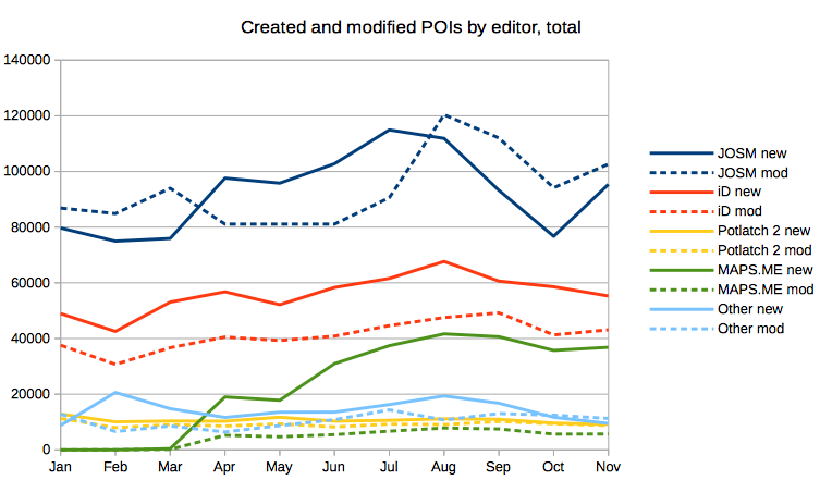
The editor usage stats wiki page has two useful tables for comparing editors: by number of users and by number of edits. And while MAPS.ME reach is clearly visible in the first one (alas, it hasn’t still surpassed iD in users), the second table has much lower numbers for the mobile editor. Which is reasonable: MAPS.ME does not allow editing geometry, thus a single user can make more edits in a day, than all MAPS.ME users in a month.

I was wondering if we could compare only the type of edits our mobile editor allows, that is, POI edits. And with daily replication diffs, I did:

Created and Modified POIs by Editor, total

This chart shows that while users of iD and JOSM editor create more points of interest than MAPS.ME users, it’s not by a large margin.

I noticed days when 10k or 20k new POIs were uploaded with JOSM, and wondered if the picture would change if we took median values for days of each month. That is, from a sorted array of numbers we would take the middle number. Turns out, not much.

See full entry

Posted by ryebread on 28 December 2016 in English.

Last time I tried to do an import, things ended up a bit ugly. I prepared all the data transformations and processes, but I did not receive the permission to use the dataset from Boston GIS, and I was not able to contact anybody from the GIS department. So I gave up. And learned from my mistakes.

After spending some time untangling the lanes on nearby highways in Greater Detroit Area and adding 5 square miles of residential buildings just because why not, I decided to see whether there is any open dataset available to tag these buildings with addresses.

After being told by my city officials that neither they nor the county we are in provide any data, I kept my hopes low.

SEMCOG

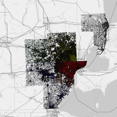
Two days ago I discovered SEMCOG, the Southeast Michigan Council of Governments, and today I wrote them for permission to import their data into OpenStreetMap.

Their coverage is huge:

SEMCOG coverage

See full entry

Location: Farmington Hills, Oakland County, Michigan, United States
Posted by TagaSanPedroAko on 27 December 2016 in English.

With Typhoon Nina (international name: Nock-Ten) wreaking havoc last December 25 and 26, it sparked my interest to map areas hit by the typhoon. While wide-scale mapping still not starting in the wake of the typhoon, I now started mapping areas for disaster response.

I started mapping areas hit by Typhoon Nina first at Catanduanaes, where the typhoon made its first landfall. at Virac, the province’s capital, I have mapped many houses there, along with roads, schools, a church, and fishponds, along with paths within them. Fortunately, those areas I mapped have traceable Bing imagery, and I traced several POI’s, like two schools, and a Mormon church, which I recognized using the aerials.

While it is still a few days after Nina wreaked havoc, I have already started mapping for disaster response, and I expect that this may be followed by Humanitarian OpenStreetMap Team projects, that may involve other mappers to map typhoon struck areas, especially on areas that lack quality aerial imagery, like most of Quezon, which has most part that lacks Bing coverage, but, Mapbox Satellite has, however, on some areas, imagery is not so fine, unless MapGive will have high-resolution imagery for mapping those typhoon-struck areas.Well, it would have been better that areas that will be affected by Typhoon Nina would have been mapped before, like what is done in Samar Island before Typhoon Ruby (Hagupit) struck Eastern Visayas and southern Luzon.

Location: Duluhan, Cuta, Batangas City, Batangas, Calabarzon, 4200, Philippines

Following up from our previous diary post on inconsistent edits observed, here are the inconsistent edits observed in OpenStreetMap between 28 November - 23 December using OSMCHA.

We commented on these changesets:

  • Deleted road: changeset 1, 2, 3, 4, 5
  • Added inappropriate name tag to the highways: changeset
  • Added building=yes to nodes for some features: changeset
  • Added lots of POI’s: changeset
  • Deleted rail road: changeset
  • Buildings that were not split: changeset
  • Circular polygon over university: changeset

Community members commented on the following changesets:

Reverted:

  • Deleted buildings: Community commented and reverted the changesets 1, 2, 3, 4
  • Deleted roads: Reverted the changeset 1, 2, 3, 4, 5, 6, 7, 8
  • Overlapping buildings: Reverted the changeset
  • Added a ton of ways with relation type=lanelet at intersections. DWG reverted the changeset
  • Fantasy mapping. Community reverted the changeset 1, 2
  • Deleted landuse. Reverted the changeset
  • Deleted track: Community reverted the changeset
  • Mass incorrect edits of road graph. We reverted 52 changesets
  • Adding bad import hotel data. Community reverted the changeset
  • Added POI to a major road. Community reverted the changeset
  • Deleted tunnel on a significant highway. Reverted the changeset
  • Added private information. Reverted the changeset

If you are interested in validation, check out our validation guide on using OSMCha. Do keep an eye out and comment on changesets which seem inconsistent to let the user know which will in turn helps users become better mappers and lets us maintain data quality on OpenStreetMap.

Look forward for another roundup next week.

Posted by andygol on 23 December 2016 in English.

Ways marked with tags highway=* form a network of roads. One of the tasks of such network is the ability to construct a route from one area of the network to another. This is possible only under the condition that these areas have common connection point — do not have gaps between them and do not form with each other, unconnected “islands”.

image

https://en.wikipedia.org/wiki/Stronglyconnectedcomponent

In addition to route planning, an important part of the map of the road network is its visual integrity. Since a different set of roads are shown on different scales (levels of generalization), it is important that the road network would look like a single entity.

See full entry

Posted by Brian Ronald on 22 December 2016 in English.

So last year I bought a new bike. I use it to commute between Jarrow and Gateshead, and on weekends I often join a social group ride from the Newcastle quayside, to various destinations. I’ve taken to tracking my rides with my phone (it’s so convenient now that GPS is all built in) and I’ve been tweaking and updating my local area.

If you see somebody on a green Brompton in the area, do wave!