Diary Entries in English

Recent diary entries

Posted by SimonPoole on 15 January 2017 in English. Last updated on 1 July 2017.

In November 2015 I produced a blog post on the relative sizes of our national communities and their development over time. When I updated the contributor stats on our wiki a couple of days back and looking at the massive impact the influx of first time users using maps.me have on the contributor numbers (not necessarily on anything else as I have pointed out in earlier posts), I thought it would be interesting to update the numbers and have a look at what has changed over slightly more than a year.

The most notable changes in the top 20 ranking by absolute community size are Russia overtaking France, Ukraine moving up 6 places and the Philippines moving in to the top 20 at the expense of the Czech Republic.
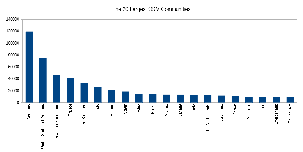
It is reasonable to assume that these changes are mainly due to the differences in the popularity of maps.me, No surprise and expected that it is most popular in Russia and the Ukraine, not so clear why it is so popular in the Philippines:

See full entry

Posted by alexkemp on 15 January 2017 in English. Last updated on 22 January 2017.
  1. There May be Troubles Ahead
  2. Errors whilst Compiling using Ant
  3. Creating Eclipse Project
  4. Eclipse Debugging Routines
  5. wORD cASE bLINDNESS
  6. Importing the Project Bugs
  7. Have you Tried Restarting Your Program, Sir?
  8. Show Your Bugs, Damn You!
  9. Be Careful What You Wish For
  10. Installing NetBeans

Under Compiling using Eclipse the Developers’ Guide says: > Use Eclipse and the provided .project and .classpath file. Just import project using the JOSM core folder as root directory.

Those are brave words, but more than a touch useless for noobs like me (how do I do that?) (and exactly why do I need to compile anything anyway, since a full build is provided? I come here to debug a plugin, not compile it).

The nightmare of Black Friday 13 & Saturday suggest that I do need to import the provided project. So, here is how to do that (and, unfortunately, import the project’s bugs at the same time):

  1. File ▸ Import
  2. (expand General) select Existing Projects into Workspace
    (press Next>)
  3. (click Browse... on Select root directory)
  4. select josm dir + press OK
     
    A ghost-in-the-machine now appears within the Projects box. The entire thing is grey rather than black (including the checkbox) and cannot be selected. After the initial checkbox, the text reads: josm (~/workspace/josm) (the dir in brackets is identical to the workspace dir that has been selected) (this result previously stopped me going any further). Under the dialog title (Import Projects) it says:
    > Some projects cannot be imported because they already exist in the workspace

  5. (click Browse... on Select root directory)
  6. select core dir + press OK
     
    The text in the Projects box now reads JOSM (~/workspace/josm/core) and is both pre-selected & selectable.  
  7. Press Finish

See full entry

Posted by alexkemp on 14 January 2017 in English. Last updated on 22 January 2017.
  1. There May be Troubles Ahead
  2. Errors whilst Compiling using Ant
  3. Creating Eclipse Project
  4. Eclipse Debugging Routines
  5. wORD cASE bLINDNESS
  6. Importing the Project Bugs
  7. Have you Tried Restarting Your Program, Sir?
  8. Show Your Bugs, Damn You!
  9. Be Careful What You Wish For
  10. Installing NetBeans

fRIDAY 13 jANUARY WAS NOT A GOOD DAY.

tHE vOGELLA TUTORIAL SAYS: > 1.4. Starting the Debugger
> To debug your application, select a Java file with a main method. Right-click on it and select Debug As ▸ Java Application.

tHAT SEEMS SIMPLE ENOUGH. hOWEVER, FINDING A main METHOD IN josm IS MUCH HARDER THAN AT FIRST IT SEEMS:-

~$ cd ~/workspace/josm
~/workspace/josm$ fgrep -ir 'main {' ./
./plugins/Mapillary/.svn/pristine/(removed).svn-base:  main {
./plugins/Mapillary/build.gradle:  main {
./core/src/org/openstreetmap/josm/Main.java:public abstract class Main {
./core/src/org/openstreetmap/josm/gui/MainApplication.java:public class MainApplication extends Main {

(aWARD YOURSELF A gOLD sTAR IF YOU SPOTTED THE -i IN fgrep)

sO, ONLY 2 SOURCE-FILES, + ./core/src/JOSM.java (DECLARED IN ./core/build.xml AS THE "Main-class"): > JOSM.java:
> /*
>  * JOSM main class (entry point of the application)
>  */

  1. Main.java : public abstract class Main
  2. MainApplication.java : public class MainApplication extends Main
  3. JOSM.java: public class JOSM extends MainApplication

nONE OF THE 3 PROGRAMS ABOVE HAVE A Java Application AVAILABLE WHEN Right-click | Select Debug As IS TRIED. hOWEVER, Debugging a Java Program, tutorials.point POINTED OUT THAT THERE WAS A KEYBOARD SHORTCUT (i LOVE KEYBOARD SHORTCUTS) (PROGRAM NEEDS TO BE PRE-SELECTED WITHIN Package Explorer): > Alt + Shift + D, J

tHAT GIVES THE VERY WONDERFUL ERROR MESSAGE: > Selection does not contain a main type

…AND THAT LEADS TO HUNDREDS OF FORUMS & OTHER SITES ALL SAYING THE SAME THING: > Your class is supposed to be called ‘main’, not ‘Main’

See full entry

OSM has (since long time) raster tiles of all uploaded GPS traces.

Since a few days they are available as a overlay (like data overlay) on the OSM.org mainpage. Hurray.

This reminded me of using the overlay of mapillary traces for OsmAnd. The same is possible with the GPS traces!

The tileset addresses are:

https://gps-{s}.tile.openstreetmap.org/lines/{z}/{x}/{y}.png and http://gps-{s}.tile.openstreetmap.org/lines/{z}/{x}/{y}.png

In OsmAnd you can use (needs the online tile plugin active)

http://gps-a.tile.openstreetmap.org/lines/{0}/{1}/{2}.png

Step-by-step instructions are shown in Peters blog.

So now you can toggle the gps and mapillary traces in osmand whatever you are interested right now.

Posted by alexkemp on 12 January 2017 in English. Last updated on 22 January 2017.
  1. There May be Troubles Ahead
  2. Errors whilst Compiling using Ant
  3. Creating Eclipse Project
  4. Eclipse Debugging Routines
  5. wORD cASE bLINDNESS
  6. Importing the Project Bugs
  7. Have you Tried Restarting Your Program, Sir?
  8. Show Your Bugs, Damn You!
  9. Be Careful What You Wish For
  10. Installing NetBeans

Hours & hours of using terms such as “bugfix” as a search-string for Eclipse in Google were getting me nowhere. I finally broke through into sunlit uplands when I tried using “Debug|Debugger” as the search-string. That led to the following tutorial:

http://www.vogella.com/tutorials/EclipseDebugging/article.html

I’m getting very frustrated at this slow progress, but perhaps need to be a little less hard on myself. Remembering that my knowledge on all these apps was zilch at the start (just a little on using Subversion), I think that I’m heading in the correct direction.

Posted by alexkemp on 11 January 2017 in English. Last updated on 22 January 2017.
  1. There May be Troubles Ahead
  2. Errors whilst Compiling using Ant
  3. Creating Eclipse Project
  4. Eclipse Debugging Routines
  5. wORD cASE bLINDNESS
  6. Importing the Project Bugs
  7. Have you Tried Restarting Your Program, Sir?
  8. Show Your Bugs, Damn You!
  9. Be Careful What You Wish For
  10. Installing NetBeans

Eclipse is an IDE (“Integrated Development Environment”). From the bug-fixing point of view, an IDE allows a program to be run until the program throws a software exception, when the IDE can re-appear, both showing the line within the source-code file that caused the error & giving opportunities to step forwards/backwards through the code, whilst examining changing values in key properties.

This is how Eclipse describes itself:- > Eclipse provides IDEs and platforms for nearly every language and architecture. We are famous for our Java IDE, C/C++, JavaScript and PHP IDEs built on extensible platforms for creating desktop, Web and cloud IDEs. These platforms deliver the most extensive collection of add-on tools available for software developers.

Having already used Subversion (SVN) to download the JOSM/plugins code, I thought that it would be easy to create a new Eclipse project from that directory, but could not find the way to do that, in spite of the advice in the Wiki: > Use Eclipse and the provided .project and .classpath file. Just import project using the JOSM core folder as root directory.

So, I decided instead to follow the YouTube Video to Checkout JOSM into Eclipse, even though it is years out of date.

See full entry

Posted by karitotp on 10 January 2017 in English.

As part of the goal of making Ayacucho the best-mapped city in Latin America, the OSM community of Ayacucho, along with the Mapbox Perú team, added 20 bus routes relations to OpenStreetMap of 22 public transport services that there are in the city.

bus1 Bus routes added in Ayacucho

During the mapping, 41 public_transport = stop_position and 15 public_transport = platform has been added/updated in downtown.

See full entry

Posted by alexkemp on 10 January 2017 in English. Last updated on 22 January 2017.
  1. There May be Troubles Ahead
  2. Errors whilst Compiling using Ant
  3. Creating Eclipse Project
  4. Eclipse Debugging Routines
  5. wORD cASE bLINDNESS
  6. Importing the Project Bugs
  7. Have you Tried Restarting Your Program, Sir?
  8. Show Your Bugs, Damn You!
  9. Be Careful What You Wish For
  10. Installing NetBeans

Having used SVN to install the whole of the build directory into ~/josm, the developer’s Wiki says:- > The easiest way to compile JOSM … is to go to the josm directory and type: ant.

Hah! This is what happened to me:

~$ cd josm    
~/josm$ ant    
Unable to locate tools.jar. Expected to find it in /usr/lib/jvm/java-8-openjdk-amd64/lib/tools.jar    
Buildfile: build.xml does not exist!    
Build failed

The reason for the error is that I’ve only got the JAVA-7 JDK installed (the default JRE is JAVA-8, but that is the runtime environment, and it is the development kit that is needed here):

~/josm$ locate /tools.jar
/usr/lib/jvm/java-7-openjdk-amd64/lib/tools.jar

The fix is to install the missing openjdk-8-jdk, which I do via Synaptic. The result is still disappointing:

~/josm$ ant
Buildfile: build.xml does not exist!
Build failed

This is getting boring. build.xml is the buildfile (configuration-file) for the compiler. It’s default location is within the root of the directory from which the compiler is launched (./). Naturally, there isn’t a buildfile in the base directory, though there is within core/ & other directories. Which one to use? Who knows?

I try to use an intelligent pin:

See full entry

Posted by alexkemp on 10 January 2017 in English. Last updated on 22 January 2017.
  1. There May be Troubles Ahead
  2. Errors whilst Compiling using Ant
  3. Creating Eclipse Project
  4. Eclipse Debugging Routines
  5. wORD cASE bLINDNESS
  6. Importing the Project Bugs
  7. Have you Tried Restarting Your Program, Sir?
  8. Show Your Bugs, Damn You!
  9. Be Careful What You Wish For
  10. Installing NetBeans

terracer is one of the JOSM standard plugins. Almost all of my work updating the map involves adding houses in Nottingham, and most of those are either Terraces, Semi-Detached or Detached houses; terracer is invaluable in adding any or all of those houses.

Unfortunately, terracer began to show bugs soon after I started using it, and it rapidly became impossible to use any of it’s Relation capabilities. JOSM core was being rewritten to move from JAVA-7 to JAVA-8 (now complete), and I have a suspicion that terracer was written in the days of JAVA-6! Whatever the case, it has degraded throughout 2016 & is now almost completely unusable (at least in my experience).

6 months or so ago I declared that I wanted to bug-fix terracer. I’ve spent all the time since then finding excuses to put off making that promise good. It’s not that I don’t want to. It’s simply that, whilst the weather is good enough, I want to get out of the house, make the survey, then get it up on the map. Before Xmas I caught two new ‘flu on the run; it took until Sunday, 8 January before I finally overcame the Bronchitus & felt strong again. Today the weather forecasters promised Britain a blast of Siberian air & snow by the end of this week. So, I’ve finally run out of excuses…

I’ve done a little C/C++ Linux/Windows programming + command-line x-compilation & bugfixing plus lots of PHP, HTML, javascript, database & other scripting, but have little experience with SVN & zero experience with ant, Eclipse and/or Java. So, as the Chinese proverb goes, the future should be interesting.

See full entry

Posted by -karlos- on 9 January 2017 in English.

London

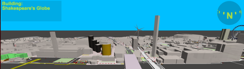
It’s still fun to improve “OSM go” and add new features. After adding some lines of code, and trees get visible; and there are really a lot of trees in OSM. The main idea still is visualising OSM data. A really realistic view may be possible and may be done (much) later (As teamwork with OSMBuildings and OSM2WORLD, I hope)

We made an experiment: OSM2WORD offers to export an area as 3D format “obj”. And “OSM go” is able to show this, including colours. Jan (OSMBuildings) exported some areas to test, they may be used as 3D-tiles in an thin client. Works fine: Twitter-Post

The controls have been reworked generally. Now there are two ways to move and look around, the ‘Inspection-‘ and the ‘Segway-Mode’. ‘Inspection’ is default, use the key “C” to change the mode. ‘Inspection’ is what you know from other 3D renderers like OSMBuildings: By keys, you move your point of view, by mouse or touch, you move the 3D world.

See full entry

Posted by Huttite on 9 January 2017 in English.

I just realised it has been 18 months since I made a diary entry! Rather than writing diary entries, I have been busy mapping. It has been over a year since Andrews Bridge at Birchville collapsed (on 29 October 2015) and I subsequently mapped this in OSM, along with the then proposed emergency access road that the Upper Hutt City Council had commenced building. Within days of me adding the proposed road as an OSM way another OSM mapper had plotted it using GPS! I was impressed. And the road was still being built, too! (This even motivated me to get my own GPS unit.) Since then I have been back and forth over this Private Road many time, usually with my own GPS unit plotting my track. (One day I should upload these tracks to OSM.)

A few days ago I sort of fell over the OSM Inspector and went back and looked at some of the work I had done over the last 18 months. I came across a few issues, but nothing that I couldn’t correct fairly easily, except that Bridge Road remains an island, despite being connected to the rest of the world by a “Private Road” even though I have changed the tags on the way to indicate there is designated restricted access rather than the road actually being “private”.

I suppose this OSM Inspector issue actually makes sense. Because the Private Road is not tagged as a public road so there is no publicly available routing to Bridge Road. Hopefully the issue will be resolved once the new bridge is installed - I am told - at the end of the month. Currently only the foundations are in place. So I think I will need to wait until opening day, so I can walk across the new bridge while plotting a GPS track.

Location: Timberlea, Brown Owl, Upper Hutt, Upper Hutt City, Wellington, 6007, New Zealand
Posted by Glassman on 9 January 2017 in English.

This is the second annual results report on welcoming new mappers. 2016 saw a large increase in new mappers in Washington State over 2015. Also a record number, 403, welcome messages sent. Last year I reported sending 106 messages with a 9% response rate. This year the response rate was 7.4% which I partially attribute to the larger sample size and to the increase in MAPS.ME users who seem to never respond.

Recently I starting using Toby Murry’s ChangesetMD tool to help identify new users. While I’m still using the IRC-Bot to identify new users, I expect to switch over to using minutely changesets with Toby’s ChangesetMD tool.

Using the new tool I was able to start capturing some new data.

  • Total new users in Washington State = 562
  • Welcome Messages Set = 403
  • Responses received = 30
  • Response rate = 7.4%
  • Percent of new users getting a Welcome Message = 72%
  • Total number of changesets by new users = 14,119

Editor Used

  • iD 474
  • MAPS.ME 53
  • Potlatch 18
  • JOSM 5
  • Go Map!! 4
  • OsmAnd 4
  • Rosemary 2
  • Gnome Maps 1
  • Vespucci 1

Some interesting statistics

  • Average number of edits by users that received a Welcome Message = 29.0
  • Average span [1] of days editing by users that received a message = 17.4
  • Average number of edits by users that did not receive a Welcome Message = 15.2
  • Average span [1] of days editing by users that did not get a message = 13.6

The numbers are encouraging me to continue to send Welcome Messages to new users. I plan to add a section with suggestions of what to edit. Cities like Seattle have quite a few features already mapped which might discouraged new users. Conversely, rural cities are pretty barren which can be just as discouraging.

Check out my current process on GitHub which includes my updated Welcome Message which includes a link to tips for Pokemon Go users.

[1] span = the number of days between first edit and last edit.

Clifford

Posted by tukangsampat on 8 January 2017 in English. Last updated on 10 January 2017.

= Update: See the comment section for clarification from HOT OSM Indonesia. Thanks bro/sist, they’re do what I thinking about during writing of this rant =

My first entry is full of rants and criticism to HOT OSM Indonesia team, the people behind #PDCSurabaya event, who allowed their participant to corrupt and demolished much of Surabaya’s data integrity on OpenStreetMap.

Despite all of “hard work” they made, I have discovered that before I partially fixed them (Gedung Keuangan Negara, schools and post office in Central Surabaya, name a few), many of already-good map data in Surabaya on OSM was lost or mangled. Building polygon ‘merged’ into area polygon as part of relations, and relations have much non-standard basic entries (address, school ownership and others, but I appreciate data additions about buildings although it is inaccurate), making it very difficult to simplify for better rendering on much-universal OSM data-based applications. Also, all third- (kodya), fourth- (kecamatan) and fifth-level (kelurahan) administrative borders are wiped (addition: not just wiping, they REALLY corrupted them. Querying locations around the Surabaya returned with empty Enclosing Features, and showing maxlat uncaught exception error on browser’s inspect tool. This is never happened outside Surabaya where administrative borders are preserved). Polygon quality are mixed, mostly poor.

If HOT OSM wishes to make another PDC on other cities in Indonesia, PLEASE RESPECT OLD DATA BEFORE EDITING! It is a valuable basis and example to be copied for the project, not egoistically wiped them for your mangled data, which for me, needs more clarity. Government or individuals must openly provide data to them, to ease their work, especially on administrative border. If you want good example, see what I mostly have done in Denpasar and Amlapura (my hometown). Unfortunately I have no time to do mapping recently due to my own real-life issues.

See full entry

Location: RW 02, Krembangan Selatan, Krembangan, Surabaya, East Java, Java, Indonesia

I am using Osmose to find and fix polygon errors in Ireland. I fixed a problem in a golf course in Youghal, Co. Cork. I could have stopped there, and moved on, however the JOSM validator found some errors, so I kept working on that little area. This led me to spot some not great mapping around a school. Some houses tagged with name=Residential Dwelling, that kind of thing. I cleaned up the area. Removed unneeded name tags, fixed tagging of roads etc. I found the mapper, and changeset where this was added, and was able to leave a changeset comment on it. I’m not the first to notice, but maybe this mapper might return to OSM.

So I feel like I have improved the map in this area. I would not have known to look there if I hadn’t use a QA tool like Osmose, or the JOSM Validator. However if I was just looking at closed polygons, then I would have stopped as soon as I fixed that polygon, and moved on.

At State of the Map 2016, Frederik Ramm talked about Mechanical Edits, and one problem he finds with mechanical edits is that sometimes people just mechanically and automatically fix the problem that the QA tool has found, rather than looking at the area, or other contributions from the same mapper, and try to fix the larger problem, and fix other problems. There is often talk about more automatic and manual imports, with some suggesting that humans are expensive, let’s not use them too often. But you need to have humans there, to find and recognise other mistakes which the tool can miss, as my example shows.

Posted by Brian Ronald on 7 January 2017 in English.

Spent today on my bike taking geotagged photographs of a local river. Every error along my way, then back home to spend time in JOSM, fixing each one.

The trouble with data imports from sources like the OS is that it just lands on top of the map. Sorting that out is as good an excuse as any for roaming around my local area on my bike taking pictures!