 OpenStreetMap

Today, someone mentioned to me that there’s an ongoing “reform” of a certain local tagging scheme.
At first, I really, really, really, really, really didn’t want to get involved at all.

But in the end, I decided to give it a try and skim the proposal anyway.
After that, I wanted to present an argument.
To support that argument, I wanted to introduce this tool that I made several weeks ago.
But then I realized that I probably never made a blog post announcing it at all.
Weird. Usually, I always make a blog post whenever I finish an app.
After double-checking everything, I think it’s safe to say that I never made a blog post about this app.
Alright. Here we go : https://altilunium.github.io/terjangkau/
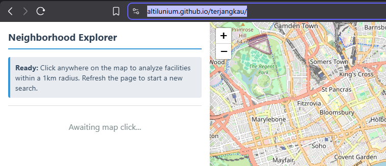
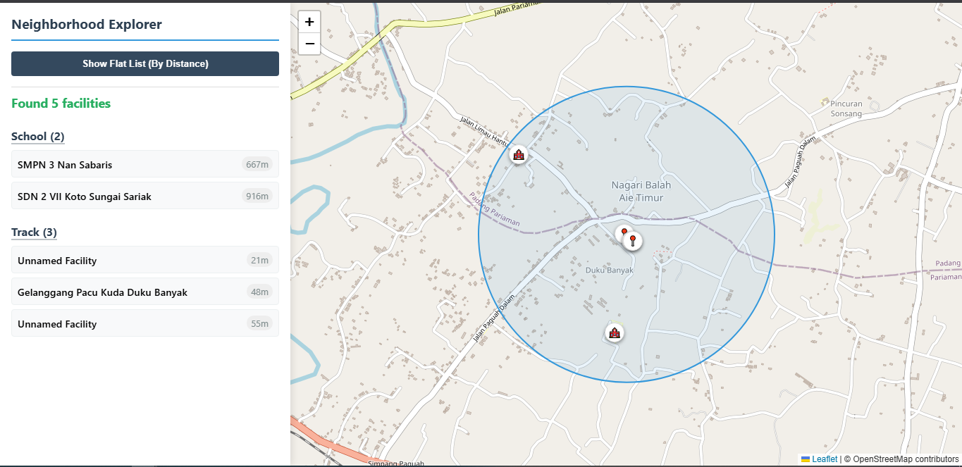
Click on any coordinate. It could be your home, your hotel room, a place you want to visit in the future, anything.
The app will query the Overpass API, retrieve all the “important facilities” around that coordinate, then show them to you, sorted by their distance from that coordinate.
Using this, you can quickly grasp “how good a place is.”
Are there any critical facilities nearby? Schools? Police stations? Fire stations? Shops? Restaurants? Other amenities?
If they exist, you can see them at a glance, sorted by distance, so you can prioritize which places you want to visit first.
Or maybe it’s not the place’s fault after all.
Maybe the facilities exist in real life, but they’re still unmapped.
You can also use this app to do a quick survey of an area. Is there something missing that still hasn’t been mapped?
Epilogue :
Turns out, I had already written something about it. But not on my OSM diary or personal blog. Instead, I wrote about it directly in both the GitHub repository and a WeeklyOSM entry.
Epilogue 2 :
Let me just translate my argument into English so the international audience can better understand the context behind this reform.
I once summarized the globally-accepted definitions of the place=* tags (see ATTACHMENT A).
My suggestion is that every decision to classify an administrative or settlement name into a particular place=* category should be both documented and justifiable, especially to OSM data users from outside Indonesia. This helps ensure that our classifications remain consistent with the international conventions behind the OSM tagging system.
It might also be worthwhile to establish a national team of OSM volunteers responsible for classifying place names across Indonesia. The team could maintain a master reference document explaining why one place belongs to a higher place=* category while another belongs to a lower one. We could even define a set of objective minimum criteria that determine when a place should be promoted from one category to another.
For example, the traditional Minangkabau criteria for establishing a nagari require four fundamental customary elements : at least four clans (suku or kaum), a mosque, a customary assembly hall (balai adat), connecting roads (labuah), and a public bathing place (tapian). These criteria are clear, objective, and measurable (population + facilities).
One of the definitions frequently used by OSM when distinguishing place=* categories refers to whether a settlement has “a good range of shops and facilities” or “few facilities available.” I’ve already built an application that can measure this. All that’s left is to define what “a good range” and “few” actually mean in quantitative terms.
ATTACHMENT A
==== place=city + capital=yes  ====
* Render : z6-z10 (circle with a dot)
* '''place=city''' : The largest settlement within a territory, including national, state and provincial capitals, and other major conurbations (an extended urban area, typically consisting of several towns merging with the suburbs of one or more cities).
* '''capital=yes''' : The capital city of the country or administrative division within countries
==== place=city + population=*  ====
* Render : z7-z10 (circle with a dot)
* '''population=*''' : To indicate a rough number of citizens in a given place. The population figure should be a stable number if possible. Typicaly, it includes residents but excludes non-residents who may be visiting the place for business or leisure. Some renderers use this key to show more populated cities more prominently, such as by labeling them with larger text, displaying them at lower zoom levels, or prioritizing them over nearby less populated places. It is recommended to also add the key source:population=* to the same object, having its value the name of the institution that counted the population and the year when the population was counted.
==== place=city  ====
* Render : z6-z14 (circle)
==== place=town ====
* Render : z9-z15 (will stop at z10 if capital=yes)
* '''place=town''' : An important urban centre that is larger than village, smaller than city, and not a suburb. Towns normally have a good range of shops and facilities which are used by the people from nearby villages.
==== place=suburb/village ====
* Render : z12-z16
* '''place=suburb''' : A major area in a town or city, with a distinct and recognized local name and identity. Suburbs may have uncertain boundaries, may overlap with other suburbs, and are often best mapped using a node.
* '''place=village''' : A smaller distinct settlement, smaller than a town, with few facilities available, with people traveling to nearby towns to access these.
==== place=quarter/hamlet ====
* Quarter render : z14-z16
* Hamlet render : z14-z17
* '''place=quarter''' : A named part of a bigger settlement where this part is smaller than a suburb and bigger than a neighbourhood. This does not have to be an administrative entity.
* '''place=hamlet''' : An isolated settlement.
==== place=neighbourhood/isolated_dwelling ====
* Render : z15-z19
* '''place=neighbourhood''' : A named, geographically localised place.
* '''place=isolated_dwelling''' : The smallest kind of human settlement. The whole settlement must not consist more than two households.
==== place=locality ====
* Render : z16-z19
* '''place=locality''' : A named place that has no population
==== place=square ====
* Render : z16-z19
* '''place=square''' : A town or village square. A (typically) paved open space, generally of architectural significance, surrounded by buildings in a built-up area. The majority of the area of this feature is paved and suitable for open markets, concerts, political rallies and other events that require a solid surface.
==== place=farm/island/islet ====
* '''place=farm''' (z15-z19) : An individually named farm, often including an area where a family of farmers resides.
* '''place=island''' (node:z16-z18, way:z4-z18) : Any piece of land that is completely surrounded by water and isolated from other significant landmasses
* '''place=islet''' (node:z17-z19, way:z11-z19) : Any very small island. Too small to support continuous occupation without shipments from other island.
Discussion
Comment from Алексей Чесноков on 21 July 2026 at 12:28
Hello rphypin, please can just revoke to block, and steps: 1. See osm.org/user/mavl 2. Click to «send message». 3. «mavl, please to revoke block of Алексей Чесноков, he loves for not blocks».