
HOT Mentorship Program 2025: Mapping Fire Incident Hotspots in Nairobi, Kenya.
In the last quarter of 2025, I was privileged to be part of the HOT Mentorship Program. I was a mentee in the third cohort, focusing on Open Community Building. I got to experience first-hand what it takes to work on an individual research project here in Kenya. My project was voluntary, but I learned a new meaning of that word through the project. According to the Oxford Learners’ Dictionary, voluntary is an adjective that refers to “actions done willingly, of one’s own accord, or by free choice, rather than being forced, paid, or compelled by law”. I understood that part very well, but I had little knowledge that free will doesn’t necessarily mean zero budget. So there was that.
What does it take to carry out a research project in Kenya?
While there is no “one size fits all” blanket that defines the needs for all projects, here are a few key points to consider before starting any project:
- General purpose of the project: academic thesis, community building, etc.
- Data: required datasets, available data sources, required licenses and terms of use.
- Scope of the project: geographical extent, objectives of the research project,
- Resource allocation: time, human resources/ stakeholder engagement, financial resources or physical resources.
- Legal Requirements: Associated licenses that may be required depending on the nature of the project.
Mapping Fire Incidents in Mukuru Kwa Njenga
Nairobi is the largest metropolitan city in Kenya, serving as a central hub for various economic and political activities in the country. Affordable housing is a major challenge in the city, leading to the formation of several informal settlements across the county, which lack proper infrastructure. Mukuru Kwa Njenga is one of these settlements. Like many others, the area is characterised by clustered mabati structures and narrow access roads that connect the region to other parts of the city. Fire incidents are a common tragedy in this area, leading to loss of property and lifelong scars.
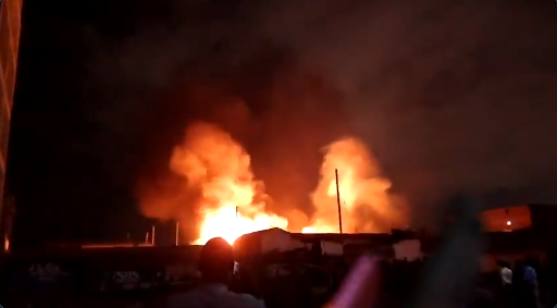 Image credits: Nairobi Leo News
Research Objectives
The main objectives of the project were:
- To identify the causes of fire incidents in Mukuru
- To map fire incident hotspots in the area
- To identify the role of community leaders and residents in fighting the recurrent fire incidents
Data and Methods
The project was mainly qualitative, seeking to understand the patterns behind the causes of recurring fire incidents in Mukuru, how the fires start and where the incidents occur frequently. The project was carried out in the following steps:
-
Data Acquisition/ Exploratory Data Analysis: Acquiring relevant data from the International Centre for Humanitarian Affairs (ICHA), OpenStreetMap and ground verification.
- Hotspot Analysis: Identifying the fire incident hotspots within Mukuru Kwa Njenga and the surrounding settlements, as established from the data and field survey.
-
Qualitative Data Analysis: Identifying the causes of fires in Mukuru and identifying the gaps in the distribution of emergency care services around the fire incident hotspots.
- Capacity Building: Conducting a fire safety awareness training and community engagement forum.
Research Findings
The following map shows the distribution of fire incident hotspots around Mukuru Kwa Njenga and the surrounding areas:

From the research findings, fire Incidents in Mukuru Kwa Njenga are majorly caused by:
- Faulty Cooker Valves: Commonly used cookers have valves that gradually become loose and pose a fire hazard caused by gas leakage.
- Traditional lanterns (koroboi): These lamps pose a fire hazard when knocked over or left unattended, and are a common cause of fire ignition.
- Abandoned cooking stoves: When cooking stoves are abandoned for a long time, they slowly ignite cooking pots and nearby curtains, hence starting a fire.
- Faulty Wiring: Most power cables in the area do not meet the required standards of installation, and they pose a risk of electrocution and ignite fires.
- Building material of the houses: Most of the houses in Mukuru are mabati houses, which are crowded and catch fire very easily
- Lack of supportive infrastructure: lack of a nearby fire station, narrow access roads, insecurity and inadequate water supply in the area slow the response rate to fire incidents in Mukuru Kwa Njenga and surrounding areas.

Challenges and Limitations
- Limited Project Funding - Challenges in facilitating the community members and field assistants who participated in the mapping exercise
- Limited Project Scope: The project only covered a few villages in Mukuru, due to limited project timelines and funding.
Recommendations
- The community members should collaborate with the Fire Brigade Team to organise more fire safety training programs
- The residents of Mukuru should replace their gas valves regularly to prevent fire incidents caused by gas leakages.
- Further research should expand the project scope to cover a wider area and propose solutions for the recurring fire incidents.
Conclusion
Recurring fire incidents are one of the major challenges that the people of Mukuru have continued to endure for several years. This project highlighted the major causes of fire incidents and mapped some of the incident hotspots within Mukuru. The OpenStreetMap database was particularly useful in geocoding street addresses, locating emergency amenities such as health centres, providing building footprint data, access roads and social amenities such as water points. The project aimed at increasing the visibility of Mukuru to the relevant stakeholders and inviting some action on the subject matter.
| Mentor: Farhina Hoque | Manager- Student Affairs | Asian University for Women (AUW) | Bangladesh. |
| Mentee: Evalyne Nyawira | Geospatial Analyst | Nairobi, Kenya. |
Discussion