OpenStreetMap logo OpenStreetMap

Users' Diaries

Recent diary entries

At the last meeting, the OSMF board gave the go-ahead to implement a new version of the OSM API. The full transcript can be found on wiki. Summary:

🧐️️️️️️Validation

Edits that break the geometry or topology will be rejected; for non-critical errors the API will return an HTTP status 267 Doubtful But Okay

🛣 New data model

To simplify the data model, it was decided to abandon the Way type. Relations are already used for multipolygons and can store lists of points, which makes Way meaningless.

This approach will also allow us to describe nonlinear geometries, which takes mapping to a whole new level 🚀

📃 New data format

The obsolete XML format will be replaced by human-readable YAML. This allows you to conveniently edit the map in any text editor and study changesets using tools such as git diff. JSON format support will remain.

👮‍♂️Pre-moderation

New users’ edits will be included in the pre-moderation queue. Edits can be approved by any cartographer who has mapped 42 days in the last year. You can avoid the queue by paying for OSMF membership.

💵 Premium Features

In addition to disabling pre-moderation, cartographers who have paid for an OSMF membership will receive priority when accessing DWG and OSMF. The duration of blockages for premium cartographers will be halved.

💎 New cgimap

The current implementation of cgimap, written in C++, does not meet the security requirements, so it will be rewritten in Rust Ruby, which is already used for most of the site.

Posted by GovernorKeagan on 31 March 2024 in English.

I’ll start this by saying I wish I had started keeping track of this from the start. I have already done some work on this personal project.


Project Introduction

Back in December of last year, I decided that I wanted to start mapping in my hometown of Gqeberha (Port Elizabeth). There were a lot of buildings missing, and I have personally experienced what it is like to not have an up-to-date map.

Since December, I have been working my way through, adding buildings in admittedly too much detail. Having grown up in the area, I had a little more knowledge of the area than just the aerial imagery could provide.

Mapping Progress

I find (and still do) it therapeutic to sit at my PC and add buildings in OSM, especially once I started using JOSM. The progress was going well, and I could really see the difference; I just wish I had taken some screenshots before starting.

There have been times when it has been really mundane, to help with this I broke down my project even further. I would focus on one area and add in as much of the missing detail as I could. I’ve done this a few times now - in between mapping of buildings - and it has really helped break up the project.

Going Forward

I think there are two main things that I want to change going forward.

  1. Taking more screenshots before I start mapping a new area. Seeing the before and after has been a real motivator.

  2. Writing more long-form progress updates. This is my first diary update about the project, and the handful of Mastodon toots have not really done it any justice. Making this public also exposes my work to a potentially greater audience, which has the benefit of me learning and improving much quicker.


Gallery: Before & After

Before: Walmer Golf Club - A lot of details missing and information that can be improved.

See full entry

Posted by NorthCrab on 31 March 2024 in English. Last updated on 1 April 2024.

Welcome to my third OpenStreetMap NextGen development diary.
This week has been super busy and I can’t wait to show you the progress 🧑‍🍳!

You can subscribe to my diary updates on RSS here:
osm.org/user/NorthCrab/diary/rss

Video Presentation 🎉

This week I was focused on integrating features together, as we get closer and closer to the first development release. I am super happy with how things are progressing and I decided to record a short video presentation (3 minutes).

⬇ Click below to play ⬇

Video thumbnail

or click here: https://peertube.monicz.dev/w/kGnomi7LTveXZNaaQtEwH6

Refreshed Changeset UI

See full entry

Asia Pacific Hub and World Vision Bangladesh Field Mapping and Data collecion Experience.

Open Mapping Guru, Brazil Singh in a field visit and data collection in Mirpur and Duaripara, Dhaka. Open Mapping Guru, Brazil Singh in a field visit and data collection in Mirpur and Duaripara, Dhaka.

On Thursday 21 March 2024, I received invitation from Open Mapping Hub Asia Pacific & also brilliant Mikko Tamura, Community Manager for Asia and the Pacific at Humanitarian OpenStreetMap Team, for the coordination of OM Guru for Dhaka Field Visit & Data Collection. I was so much exited, and I accepted the invitation instantly. And then I got the news about the guests who are coming to Bangladesh and they were Can Unen, Senior Manager for Community & Partnerships, Humanitarian Openstreetmap Team , Honey Grace Fombuena, GIS AnalystGIS Analyst, Humanitarian OpenStreetMap Team and Harry Mahardhika Machmud, Senior Program Manager for Asia-Pacific at Humanitarian OpenStreetMap Team

See full entry

Posted by b-unicycling on 29 March 2024 in English. Last updated on 7 April 2024.

I was lucky enough (or maybe deserving) to have been granted one of the GoPro Maxes sponsored by Meta, a project organised by OSM Belgium - many thanks for that!

I’ve had it for a week now, and I’ve been very busy with it - around 12.643 images captured so far (some nearly duplicates I deleted and some without GPS data I didn’t bother adding it to). I don’t drive, so I only went about on my bike and on foot - so far, but I would like to try it on a car roof at some point.

My first stop was St. Mullin’s in Co. Carlow, a small village, but more importantly early Christian monastic site and National Monument. There is a relatively new bus route (887 Local Link) going there which hadn’t been mapped yet, so I took the bus from Carlow to St. Mullin’s to track the route and bus stops. The bus driver was kind enough to tell me where the bus stops were, because for most of them, they are not signposted. (Trace 1 and Trace 2, if anyone is interested, but the routes are mapped so far) Mapillary shot of bus at Carlow Train Station at unsigned bus stop

See full entry

A Step Forward in Mapping Together

Hello, OpenStreetMap Community!

We at Mapilio are thrilled to announce a significant update that’s been in the works for some time now — the integration of our imagery layers into OpenStreetMap, available through the iD editor. This collaboration represents a milestone in our ongoing commitment to enhancing the mapping experience for everyone in the OSM community.

ID ## Why This Matters

The power of OpenStreetMap lies in its community and the collective effort to create the most detailed, open-source map of the world. By integrating our high-quality imagery layers from Mapilio, we aim to empower mappers with even more tools to enhance accuracy and detail in their mapping endeavors.

Collaboration at Its Best

See full entry

♪♫ When Girls Just Want To Have Fun ♫♪

On March 23, 2024, as part of the Women’s Month celebration, the Viscan YouthMappers organization conducted a mapping activity titled “MapaBabae: When Girls Just Wanna Have Fun Mapping the Streets Using Mapillary.” This initiative aimed to pave the way for women’s empowerment through mapping, celebrate the contributions of women in the field of mapping, and inspire each other.

1e85bda5-9a78-41f1-9e40-40b1033310ca

It started with an introduction of mine about what the Mapillary is all about which will be used by us by updating the streets of our University Campus that hasn’t been captured last mapillary event. Sharing that Mapillary is a collaborative street-level imagery platform wherein participants in MapaBabae are able to document their journeys and highlight points of interest, and share their stories regarding about this acivity. At its core, MapaBabae is about more than just mapping streets; it’s about creating a community where women feel seen, heard, and valued.

See full entry

Location: Guadalupe, Patag, Baybay, 5th District, Leyte, Eastern Visayas, Philippines

English below / Português abaixo


Il y a presque cinq ans, lors du SotM 2019 de Heidelberg, j’avais présenté une analyse critique du concept de mapathon sous le titre de « Mapathon Mapathon Mapathon ». L’historique du concept rappelait combien il s’agissait au début de projets menés sur plusieurs jours, pour devenir ensuite ce que j’ai appelé le mapathon 2.0, une action de cartographie collaborative sur imagerie dans une durée qui s’étend rarement au-delà de deux ou trois heures, avec des objectifs variables, au-delà de la donnée produite : promotion du projet OSM, engagement ou renforcement communautaire. communication sur un projet ou la structure organisatrice de l’événement…

Je ne pense pas que ce format 2.0 ait évolué depuis, mais il y a un aspect que j’avais identifié à l’époque sans pour autant le développer : le mapathon 2.0 en tant que forme privilégiée pour former de nouveaux contributeurs et contributrices OSM.

On pourrait penser qu’il ne s’agit pas d’une rupture avec le passé, mais plutôt d’une suite assez logique de la manière de former de nouvelles personnes à OSM avant l’avènement des smartphones, qui dans mon souvenir se sont démocratisés au Sud à partir de 2015 environ (voir ce graphique de l’International Telecommunication Union). Toute contribution dans OSM se faisait alors forcément en salle, vu que les moyens de collecte sur le terrain (terminaux GNSS classiques type Garmin Etrex ou cartes imprimées de type Walking Papers ou Field Papers) nécessitaient une reprise des données brutes du terrain sur ordinateur avec son éditeur préféré.

See full entry

Posted by jfd553 on 28 March 2024 in English. Last updated on 2 April 2024.

The Magdalen Islands (Îles-de-la-Madeleine) are an archipelago located in the center of the Gulf of Saint Lawrence (Eastern Canada). The heart of the archipelago is made up of seven rocky islands connected by long sand barriers, sand spits, dunes, and salt marshes. Including internal lagoons, the islands cover about 330 square km. The archipelago is sparsely populated and counts about 12K permanent inhabitants.

In June 2023, OSM describes the islands’ coastline, road network, some trails as well as some human and natural features. Overall, the islands were mapped using about 56K nodes, 5K ways, and 116 relations (Figure 1).

Figure 1 
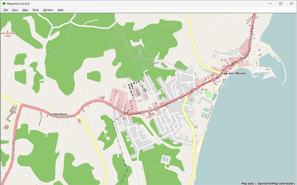
Figure 1: Cap-aux-Meules, before starting the project—Historical OSM data as of June 30, 2023, on Maperitive.

See full entry

Location: Les Îles-de-la-Madeleine, Urban agglomeration of Les Îles-de-la-Madeleine, Gaspésie–Îles-de-la-Madeleine, Quebec, Canada

藉由 TomTom 台灣辦公室牽線,由他們成大測量系系友去洽談,再加上 OpenStreetMap Taiwan 申請社群的 Tasking Manager 管理權限,能夠新增適合本地進行的專案,才有此次的機會前往成大進行 OpenStreetMap 圖客工作坊,並且用 Tasking Manager 來分配繪製台灣本地圖資。

Tasking Manager 
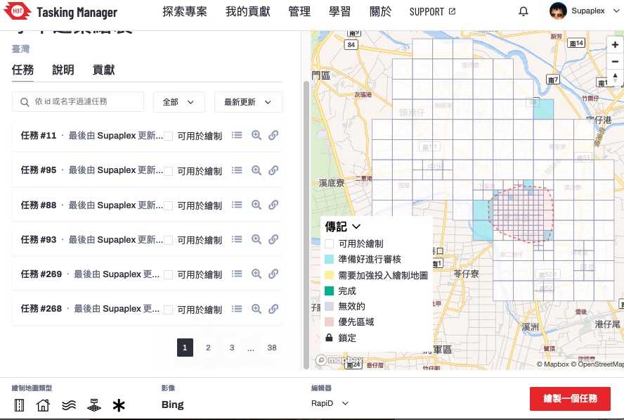
▲ Tasking Manager 的專案,本次要繪製的範圍台南學甲區

本次成大圖客松截至 3/26 共計 107 個編輯變動,29 個工作人員的編輯變動,3個社群朋友的編輯變動,22 位學生投入編輯總共有 75 個編輯變動,設定繪製目標的建築,總共畫出 369 棟。

學生實際動手之後,投入狀況還不錯,先介紹他們 OpenStreetMap 的基礎知識,再來知道資料怎麼產生,最後自己動手來做。由於整體時間只有一個半小時,並不太夠,除非選到比較郊區的任務,不然連一塊當中的建築都畫不完。

這次邀請方是成大測量系,與老師聊天時,他們蠻常運用 OpenStreetMap 資料,然後社群部分跟早年的 OpenStreetMap 台灣社群活躍者 Dongpo 比較熟,與 OpenStreetMap 相關認識是從 Dongpo 來的,也蠻合理的,因為 Dongpo 是相同空間資訊學科背景的。

See full entry

Location: 大學里, 東區, 三份仔, 臺南市, 701, 臺灣
Posted by hasienda on 27 March 2024 in English.

not been lazy but busy with so many other things, but got suddenly a new JOSM install fit for use an got catched for a few hours by now: I read some old wiki docs from 2008/09 i. e. the pilot work for Karlsruhe house number tagging schema in our town, added a few obviously missing objects, peeked into current issues nearby on Osmose did some corrections - all that feels good, this might even start a new series of contributions. :-)

Location: 50.949, 13.928

Overpass Turbo Query

10 examples of overpass queries to be used in Openstreetmap

Exemplos OVERPASS

• PTo query objects in another municipality, use this part of the query in red to change the name of the Municipality and state and you will have a search for objects in your location. • for a search by neighborhood, enter the name of the neighborhood and the city of the search

“Exemplo”

[out:json][timeout:25]; // fetch area “Terceira” to search in {{geocodeArea:campos dos goytacazes,rj}}->.searchArea; // gather results


Consulta de Ilha

[out:json][timeout:180]; area [‘ISO3166-2’ = ‘BR-PA’][admin_level=4] (area.a) -> .uf; nwr [place~”islet|island|archipelago”][name] (area.uf); out geom;


Consulta de Escolas em Município

See full entry

Location: -8.127, -34.904