 OpenStreetMap

Deletado
Users' Diaries
Recent diary entries
Posted by Romeo Ronald on 10 October 2023 in English.

As a proud resident of Juba, the capital city of South Sudan, and a team leader of the OSM South Sudan, I’ve witnessed the winds of change sweeping through our beloved city. It’s a transformation that holds the promise of reshaping our lives, empowering our community, and charting a new course for Juba’s future. At the heart of this metamorphosis is Juba’s journey towards becoming an open-source city, a path significantly influenced by projects like #ASKNet Access to skills and Knowledge, Wikimedia Community User Group South Sudan and open mapping—a benchmark of this revolution.
Embracing Open Source: What Does it Mean?
Before delving into the profound influence of open mapping, let’s grasp what it means for Juba to be an open-source city. Essentially, it signifies a commitment to transparency, accountability, and active citizen participation. It’s a city where information flows freely, governance is collaborative, and innovation flourishes.
The Role of Open Mapping: Charting New Possibilities
Open mapping stands as a pivotal benchmark of Juba’s open-source revolution. It’s a movement that has profoundly impacted our city, unlocking new possibilities and transforming the way we interact with our urban environment.
1. Navigating the City with Precision: Juba’s dynamic growth posed a challenge for residents in terms of navigation. Thanks to open mapping initiatives, we now have access to detailed, up-to-date maps of our city. Whether it’s finding the quickest route to work or discovering a hidden gem in our community, open mapping has made life easier and more convenient.
2. Empowering Disaster Preparedness: The significance of open mapping came into sharp focus during times of crisis. It’s remarkable how open mapping has contributed to enhanced disaster preparedness. In times of natural disasters, such as floods, the ability to access real-time information about affected areas and potential evacuation routes is a lifeline for our community.
Posted by Raquel Dezidério Souto on 10 October 2023 in Brazilian Portuguese (Português do Brasil).
Last updated on 10 February 2024.

Mapeamento colaborativo
Recentemente, uma discussão entre mapeadores levantou a questão da utilização da base cartográfica mundial do OpenStreetMap, por entidades humanitárias internacionais, como os Médecins sans frontières (Médicos sem fronteiras), Red Cross (Cruz Vermelha), Humanitarian OpenStreetMap Team (Time Humanitário do OpenStreetMap) ou o UN Maps (programa ligado às missões de paz das Nações Unidas).
O projeto OpenStreetMap OSM teve seu início em 2004 e, quase 20 anos depois, conta com milhões de usuários e bilhões de feições mapeadas em diversas regiões do mundo. Para muitas destas regiões, os dados do OSM são os mais atualizados, ou mesmo os únicos disponíveis. Especialmente, em regiões rurais e distantes dos grandes centros urbanos, como diversas cidades das regiões Norte, Nordeste ou Centro-Oeste do Brasil [1].
Algumas campanhas de mapeamento (mapatonas), realizadas em resposta à ocorrência de eventos extremos, como inundações, movimentos de massa ou terremotos, produziram mapeamentos em tempo muito reduzido - como a mapatona da cidade de Petrópolis (RJ), realizada no início de 2023 e completada em apenas uma semana, após os eventos de deslizamentos de terra e inundação da cidade.
Ou a mapatona da cidade de Muçum (RS), realizada em 2023, cuja rapidez pode ser vista no vídeo elaborado por Fidelis Assis:
We purchased 10 acres of land at this location
Posted by Raquel Dezidério Souto on 9 October 2023 in Brazilian Portuguese (Português do Brasil).
Last updated on 12 February 2024.
Um evento especial
Entre os dias 31 de setembro e 04 de outubro de 2023, foi realizado o State of the Map Brasil 2023, evento que reuniu os mais ativos grupos de mapeadores do OpenStreetMap (OSM) e incluiu preleções sobre o estado-da-arte da pesquisa e desenvolvimento com OSM no Brasil.
Contribuímos na organização, com a parceria do Instituto Virtual para o Desenvolvimento Sustentável - IVIDES.org, e a apresentação de três palestras e uma exposição virtual - Amazônia no Mapa, com uma seleção dos mapas confeccionados pelos participantes da OBRAC 2023.
A Conferência foi promovida pela Universidade Federal do Paraná e coordenada pelo Laboratório Geoespacial Livre, em cooperação com vários capítulos YouthMappers brasileiros.
Curso OpenStreetMap 2023 - fluxo contínuo - certificados 2×/ano
➡️ PDF - https://l1nk.dev/8Q5bL
🎥 Vídeo palestra - https://www.youtube.com/watch?v=J_O36g7B6uY&t=120s
➡️ Website do curso - https://ivides.org/curso-osm-2023
Exposição Amazônia no Mapa
➡️ PDF - https://acesse.one/b00hD
🎥 Vídeo palestra - https://www.youtube.com/watch?v=J_O36g7B6uY&t=6793s
➡️ Atlas Digital - https://ivides.org/olimpiada-brasileira-de-cartografia-obrac-2023/exposicao-virtual
Apresentação do Capítulo YouthMappers UFRJ
➡️ PDF - https://acesse.one/m0dGv
🎥 Vídeo palestra - https://www.youtube.com/live/l1_ytUEImnc?feature=shared&t=36
🌎

I’ve been diligently putting some truly boring information about my local High Street. Removing shops that don’t exist, adding new ones and adjusting opening times. It’s a shame businesses do not feel the need to do it themselves on OSM. I was wondering why is this, but then I realised that none of the navigation application I am using displays this information. I can check it on the Every Door and that’s pretty much it. Google Maps, by comparison, makes it really easy to see it and at the same time warns you of closing times, which makes it really practical in urban setting.
Having made comparison to the Map-That-Cannot-Be-Named, I realised how inaccurate Her* data is for my immediate neighbourhood. I’ve looked up some other places and though it would always take me more or less to the right location, the exact positions or addresses were off by quite some margin. At the same time, kudos to the interpolation heuristics that can find approximate addresses even in the absence of good data.
Especially that I am now realising how difficult addressing is. In my naivety I always though of streets as linear objects, with Hausdorff dimension 1 and ordered house numbers perhaps with an odd/even partition. Couldn’t be more wrong. I need to file a request to change the name of Dale Lane to Fractal Lane or Hausdorff Street (strasse?) to celebrate its many dendritic offshoots and arbitrary switch from consecutive ordering to odd/even ordering.
*Maps are feminine, right? Just like ships or cars.
Posted by barefootstache on 8 October 2023 in English.

Taking a brief look at the Croatian country side, one will notice that lots of the tracks/paths end without an exit. Additionally, when navigating at location, one will realize that only a fraction of such highways exist on the map.
How to plan a route for exploring?
The amount of exploration sections should reflect one’s physical capabilities. In the beginning about one exploration per route should suffice and can be increased through practice and knowledge of the area. One shouldn’t bite off a bigger chunk before one can handle it.
In this example of about 16km route
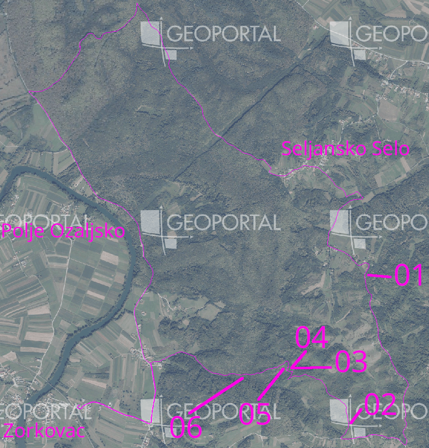
I chose one exploration section every 5km in such a matter that not more than 500m of distance was needed to be explored.
There was one section in the north that was an easy gravel highway connection,
Posted by umbraosmbr on 8 October 2023 in English.

STATE OF THE MAP BRASIL 2023
CURITIBA - BRASIL

UMBRAOSM - union of brazilian openstreetmap mappers
UMBRAOSM
Boot scrapers have fascinated me since Helge Schneider’s musical “Mendy das Wusical” in which they play a very important role. #stiefelabstreifkante (It’s a somewhat absurd musical by my favourite German comedian…)
I remember that when I moved to Ireland I kept sending my sister pictures of the ones I came across, because she also likes the musical and the comedian.
For some years now I have been thinking that it would be interesting to map them. Partly because I wanted to know how many there are in Kilkenny and where and also, you never know who might be interested in this data in the future, so OpenStreetMap is the obvious choice to record them.
 A.-K. D., CC BY-SA 4.0 https://creativecommons.org/licenses/by-sa/4.0, via Wikimedia Commons
At this point, if you get tired of reading - I’ve made a video about it: watch video on YouTube
Posted by Biomassa Defender on 7 October 2023 in Brazilian Portuguese (Português do Brasil).
Teste
While I was mapping house numbers and other things in Ballyragget today, I noticed something curious: Buildings with “Step” or “Steps” in their name. There is a “Step House” in Ballyragget (check on OSM), probably called thus, because it has 5 steps leading up to the front door (a common feature in Georgian buildings). To my knowledge, there are only one or two more houses like that in Ballyragget, so having steps outside your front door must have seemed remarkable enough for people to give it that name.
 A.-K. D., CC BY-SA 4.0, via Wikimedia Commons
Then two other cases came to mind: the Steppes Bar in Callan (check on OSM) which seems to be named after the steps to the left of the entrance. Weird plural, but maybe it’s from ye olde times.
.jpg)
sdfds
Posted by 真中あお on 5 October 2023 in Chinese (China) (中文(中国大陆)).
Last updated on 15 December 2025.

摩崖石刻
historic=epigraph 似可,但目前使用较少
窑洞
可能 man_made=cellar_entrance 较好?
最高峰另有命名的山
natural=massif 据其wiki页可用于此用途,然而用者寥寥,且不允许为点状。
绿化带
landuse=village_green 、landuse=grass 不允许线状。
停船处
mooring=* 和 man_made=quay 不允许点状,leisure=marina \ amenity=ferry_terminal 允许为点状但前者是用来表示整个码头的(而不是泊位那块岸边)、后者专用于渡船上下客处。
宽阔的阶梯
似乎可以用 area:highway=steps ?
政府部门的院落
只有 amenity=townhall 、 office=* 不加别的标签就会渲染成点。 landuse=commercial 直觉上就不对;字面上比较符合的 landuse=institutional 、 landuse=governmental 、 landuse=civic_admin ,用的人都少,前二者在wiki分别标为“有争议”,“放弃”,第三者倒是“使用中”但不在 landuse=* 页的列表里,且都不渲染。
驾校考场
Невельск
Анива

I’m doing really, really detailed reed beds in Etulia Nouă, Moldova.
Moldova and it’s state
Moldova is not very detailed. In fact, most natural features aren’t even mapped. There are only roads, rough shapes of towns and town nodes. I’m currently creating lots of detailed reed beds and natural features there, especially near Lake Cahul.
Start detailing!
 I invite everyone to start detailing the undermined country of Moldova. It’s really beautiful! I’m detailing areas around Etulia Nouă, but you can pick any area you want, like Bălți, Giurgiulești, Comrat.
I enjoy reading people’s diary entries, so I’m starting my own. My current project is mapping public bookcases (PBs) in neighborhoods near me.
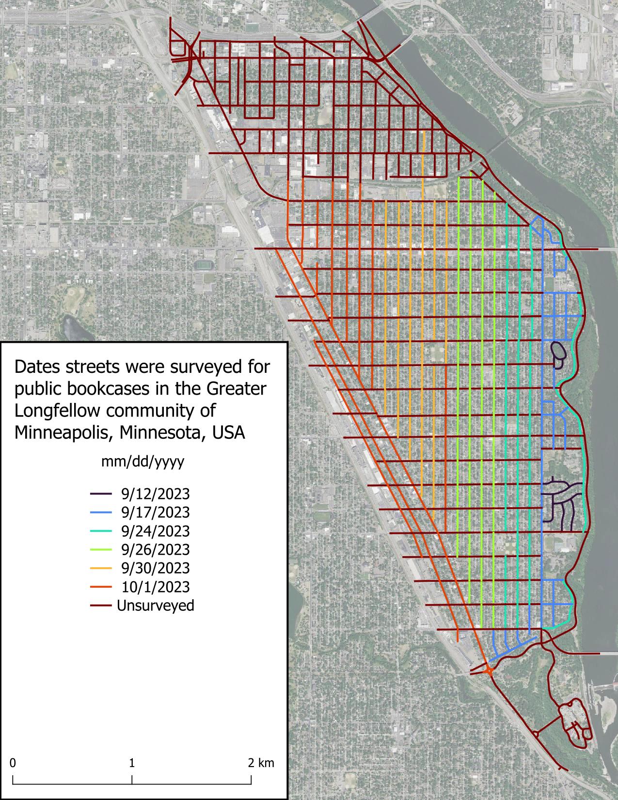
I started this project because I chance upon PBs when going for walks and can never remember where a PB is when I need one. There’s a map of Little Free Libraries (LFLs), but adding PBs to this map is “pay to play” which I don’t like, in addition to not displaying unaffiliated PBs. Other secondary goals include:
It seems I have developed a reputation in Ireland and the UK about my history mapping, because SK53 had tagged me in a toot about Martello towers. At first, I somewhat brushed it off, but as he probably knew, my interest was eventually triggered and I looked into the matter.
I remember that DeBigC was the first to tell me about Martello towers, but I can’t remember if he used a specific example or just shared his interest.
For those who aren’t familiar: Martello towers were built by the British Empire at a time when they were still ruling the waves, especially around the time of the Napoleonic Wars, when there was a threat of a Napoleonic invasion into British territory. They continued building them in port towns, so mostly along the coast, but not all of them are coastal. Apparently (according to Wikipedia), they are usually round and built in two levels with the guards living in it (i.e. building). They placed a cannon on the top which had a 360° reach, although one hopes that they only pointed it seawards.
The good news was that a lot of them were already mapped on OpenStreetMap, mostly with name=Martello Tower. The bad news (as pointed out in the toot) was that there was no consistent tagging scheme. Most of them were mapped as man_made=tower, and some had some sort of historic tag on them (ruins/ castle/ yes etc), but few were mapped as buildings. So, I came up with historic=martello_tower, skipping the proposal process and documented the tagging scheme in the wiki.