Users' Diaries

Recent diary entries

본디 글은 OSM에서 ‘길’(Key:highway)에 대한 정리입니다. 본디글이 나중에 더 다듬어 졌을 수 있습니다.(2023년 4월 29일 마지막 고침)

지도에서 중요한 요소이기도 한 ‘‘이 OSM 편집에서는 참으로 애매하고 그래서 사람마다 받아들이는 것이 달라 제각각으로 규정하는 요소이기도 합니다.
여러 군데서 말했지만, 이는 아마도 일단 동양(동아시아?)와 서양(유럽과 미국?)이 발전해 온 역사하고도 상관이 있는 것 같고(서양은 ‘길’ 중심, 동양은 ‘마을’ 중심이라는 비교문화학 쪽의 해석도 있습니다.) 나라마다 사정이 다른 데에도 큰 까닭이 있는 것 같습니다.
그래서 여기서는 굳이 OSM 위키문서의 분류 기준에 우리나라 도로를 억지로 끼워넣지 않고, 그냥 개념을 이해하기 위한 해석 정도만 해 볼까 합니다.

주요도로‘에 대하여

‘주요도로’는 길(도로)의 등급 분류라고 볼 수 있습니다. 이것은 단계적 분류라고 볼 수도 있지만, 홀로 특성(요건)을 가진다는 뜻도 있습니다.(쉽게 말해 highway이면서 일부 residential 혹은 service의 속성도 가질 수는 없다는 뜻입니다.)
‘highway=motorway’는 확실히 고속도로가 해당이 되겠고, ‘highway=trunk’는 한국 실정에서는 ‘고속화도로’(도시고속도로 등)에 걸맞을 것 같습니다.(‘고속화도로’와 가끔 헷갈려 하는 ‘자동차 전용도로’ 설명은 아래에 있습니다.)
아~주 헷갈리는 것으로 ‘key:expressway‘가 있습니다.
‘highway=primary’, ‘highway=secondary’, ‘highway=tertiary’, ‘highway=unclassified’, ‘highway=residential’을 구분짓기는 쉽지 않은 것 같습니다.
어떤 분은 (motorway, trunk 말고는)도로의 차선 수나 도로 폭 같은 것을 기준으로 나누자고 하는 의견도 있으나 우리나라 도로체계와 실제 도로를 견줘보자면 차선 수나 도로 폭의 넓이가 도로의 계층적 구분 기준과 맞아떨어지지 않는다는 걸 알 수 있습니다.(이 부분은 아직까지는 도저히 제대로 정리가 되지 않으므로 더 공부해서 정리를 해 보도록 하겠습니다.)
아마도 이 부분이 ‘길’ 중심의 서양 혹은 땅이 넓은 나라와 ‘마을’ 중심의 동양 혹은 땅이 좁은 나라의 차이가 아닐까도 싶습니다.
highway=residential : 마을 사이를 연결하는 기능은 없으며 주택 접근 시 사용하는 도로. 여기서 ‘연결’은 마을 사이를 잇는 주도로로 쓰이지 않는다는 뜻이지 길로써 이어지지 않는다는 뜻은 아니라고 봅니다. OSM 의 웹편집기인 iD에서는 ‘주거 도로’라고 번역되어 있으나 아래 비주요도로와 함께 보자면 꽤 헷갈리는 번역이라고 봅니다.(번역 탓이 아닌 개념의 상대성 탓)
우리나라의 왠만한 마을 안길, 이면도로는 residential이거나 unclassified(OSM 위키문서에 남한에는 적용되지 않는다고 되어 있습니다.) 아주 가끔 다른 주거지와 연결하는 구실이 큰 경우에는 tertiary로 쓸 수 있지 않을까 싶습니다.
(다시 정리해서 조금 덧붙이자면, 우리나라 상황과 실정에 비추어 개념이 서로 좀 겹치는 것 같기는 하지만 우리나라에서 왠만한 주거지 안의 비주요도로, 이면도로는 living_street 보다는 residential 쪽이 더 알맞지 않나 하는 것입니다. 주택단지나 아파트 단지 안길은 오히려 living_street에 가까워 보이고…)

‘고속화도로’와 가끔 헷갈려 하는 ‘자동차 전용도로’는 도로의 분류 체계가 아니라 그냥 속성으로 보아야 합니다. 어차피 motorway나 trunk에는 그 길을 쓸 수 있는 교통구가 지정되어 있으므로 따로 덧붙일 필요가 없으며, 그 밖의 의 경우에는 주요도로의 속성에 ‘motorroad=yes’를 곁들여서 써야 한다고 합니다.(OSM 사랑방에서 ‘曹县18环’ 님 글.) – 자동차전용도로, 고속화도로(도시고속도로) 지도(비공식입니다.)

연결도로‘에 대하여

See full entry

Posted by courtiney on 1 May 2023 in English. Last updated on 26 May 2023.

Hi, everyone,

Between the end of April and mid-May, my former TomTom colleagues * and I posted a communications survey with the goal of gathering some information about how OSM users experience OSM community communications. Now that the survey is complete, I want to give it context as part of our presentation at State of the Map US in Richmond, Virginia.

At SotM US, we will be presenting on How to Use Data for Effective Community Communication. (The project is supported by TomTom and informed by work that two of us have done for the CWG, but it’s not formally a TomTom or OSMF project.) Our primary source of data for this presentation is derived from a tool that scrapes publicly available, anonymized, channel data from OSM listservs and forums. To augment this data, we created a communications survey. We knew that we would not be able to get a broadly representative cross-section of the OSM user demographic with our limited time and resources, but we did believe we would get some additional details that could help inform our approach.

The survey had a mix of free answer and multiple choice questions about demographics, local community involvement, and experiences using the various forums, lists and other channels. We created 12 versions of the same survey to post in 12 different channel types so that we could get a sense of the user demographics per channel: community forum, mailing list, Telegram, Twitter, Discord, Slack, Mastodon, Reddit, IRC/Matrix, weekly OSM, Facebook, LinkedIn. We received 464 responses, with more responses from Europe and North America than from Latin America, Asia and Africa. We will present a few of the observable trends at our presentation, with the caveat that they are more impressionistic than representative.

See full entry

Location: White River Junction, Hartford, Windsor County, Vermont, 03784, United States
Posted by YPGGUUY on 30 April 2023 in Chinese (China) (‪中文(中国大陆)‬). Last updated on 6 May 2023.

https://github.com/OSMChina/osm-busqc

简易的公交网络检查脚本
* 打印全部线路
* 检查线路主线/具体线路缺失
* 检查线名/站名缺失
* 检查首末站

可能倒闭也可能变质.

A little weekend project to check local bus network integrity.
* print all routes and stops
* check missing master routes/routes
* check missing names
* check inconsistent terminals name by comparing route[from]/[to] with platform[name]

may or may not maintain or further develop.

Depends on osm_easy_api, thanks to them.

samples:

首末站不正:

主线 2
2 路: 火车站综合体 -> 塔东路东堤湾
火车站综合体 波海公园 西江北路中 体育中心西门 体育中心南门 康乐北路 康乐市场 康乐中路 披云楼 北门 豪居路 中心市场 大柑园 工农北路南 友谊路口 和平路中 城东公园北门 前进中路 市公安局 前进南路 塔东路东堤湾 和平路西 华佗医院
wrong on route 13853854
AssertionError: inconsistent terminal
2 路: 塔东路东堤湾 -> 火车站综合体
塔东路东堤湾 前进南路 市公安局 前进中路 城东公园北门 和平路中 端州公安分局 端州四路东 工农北路 友谊路口 工农北路南 大柑园 中心市场 豪居路 北门 披云楼 康乐中路 康乐市场 康乐北路 体育中心南门 体育中心西门 西江北路中 蕉园 波海公园 火车站综合体

线路缺失:

主线 5B
5B 路: 火车站综合体 -> 岭塘村
火车站综合体 大桥路北 华英名都 惠民居 玑东路南 大鼎路中 一中实验学校 太和南路 端州七路中 睦岗 八中 棠下 肇庆大道西 三榕港 三榕水厂 黄禁 大龙桥 小湘军校 新屋村
wrong on route 14464670
AssertionError: inconsistent terminal
wrong on master 15749944
AssertionError: inconsistent route count

主线缺失:

wrong on master 35
AssertionError: missing master 35
wrong on master 36
AssertionError: missing master 36
wrong on master K01
AssertionError: missing master K01
Location: 文明社区, 城东街道, 端州区, 肇庆市, 广东省, 526040, 中国
Posted by Peter Elderson on 30 April 2023 in English. Last updated on 13 May 2023.

Turbo roundabouts are relatively new. They first appeared in Nederland, but are now starting to appear in many countries, including the US. I have tried my hand at mapping one, guided by a few front runners, then did a second one on my own. This diary entry details what I learned. As I go on, I will add things learned to this diary entry!

See [roundabout=turbo] (osm.wiki/Tag:roundabout%3Dturbo)

Variations: It’s hard to find two turbo roundabouts that are exactly the same. This is what I learned: Take care to start with an easy one, and never blindly apply the prescriptions. You have to know what it’s for. That’s why this diary entry contains a lot of explanation: those are the things I learned from the experts! Too bad the three-lane rotor roundabout in Rosmalen has already been mapped.

Mapping a turbo roundabout with JOSM

Tools used

JOSM with a detailed aerial photo background layer and style Lane and Road attributes active. This job would be near impossible with Id.

Skills required

Basic OSM editing: drawing and tagging nodes, ways, areas and relations. Cutting ways (P). Link ways to existing nodes and ways (Esc-drop, M, N). Unkink ways. Extend ways. Combining ways (C). Reverse ways (R). Copy and paste elements (Control-C and Control-V).

Skilled editing: Adjusting lines with O (round) and Q (straight). Create turn restriction relations: tag, add elements and assign roles to, via from. Use existing turn restriction to duplicate and adapt for a new restriction. Route relations: download members, identify ordering problems and membership problems, and correct sorting errors.

What?

See full entry

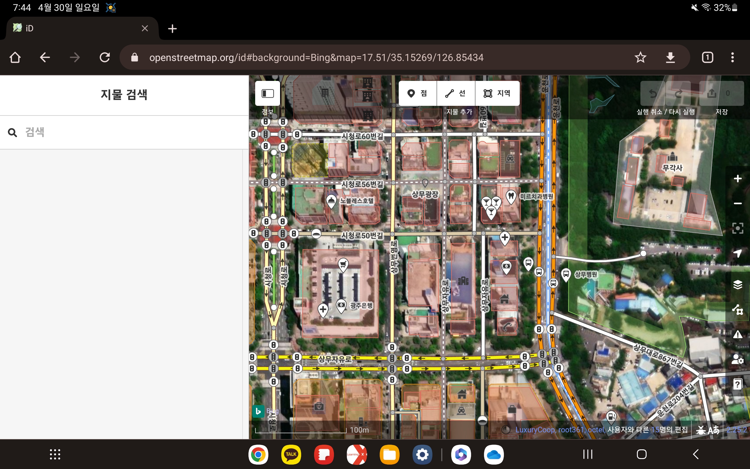
Anton Khorev 님의 글을 보고 세로 화면이 아닌 가로 화면으로 iD 편집기를 열면 어떻게 될지 한번 알아보았습니다.

태블릿에서 iD 편집기를 연 모습

갤럭시 Tab S7에서 구글 크롬으로 iD 편집기를 열어 보았습니다. 이 상태에서도 충분히 편집이 가능하지만, 전체화면으로 바꿀 수 있다면 더 좋을 것 같습니다.

See full entry

Posted by Frank Peng on 29 April 2023 in English. Last updated on 4 January 2026.

This diary entry was formerly titled “Sock puppet accounts on OSM”.

What is a sock puppet account?

A sock puppet account is defined as a person whose actions are controlled by another. It is a reference to the manipulation of a simple hand puppet made from a sock and is often used to refer to alternative online identities or user accounts used for purposes of deception. Online, it came to be used to refer to a false identity assumed by a member of an internet community who spoke to, or about, themselves while pretending to be another person.

The use of the term has expanded to now include other misleading uses of online identities, such as those created to praise, defend, or support a person or organization, to manipulate public opinion, or to circumvent restrictions, such as viewing a social media account that they are blocked from, suspension, or an outright ban from a website. A significant difference between a pseudonym and a sock puppet is that the latter poses as a third party independent of the main account operator. Sock puppets are unwelcome in many online communities and forums. https://en.wikipedia.org/wiki/Sock_puppet_account

Why do people create sock puppet accounts?

One reason for sock puppeting is to circumvent a block, ban, or other forms of sanction imposed on the person’s original account. A sockpuppet is a false online name and profile created to hide the author’s identity, usually because of personal, political, or financial ties to whatever is being discussed or reviewed. (News Literacy Project, Para. 2)

Sock puppet account vandalizes OSM

See full entry

Location: Lawrence Park South, Eglinton—Lawrence, Toronto, Golden Horseshoe, Ontario, Canada
Posted by Frank Peng on 29 April 2023 in English.

I’ll mostly be fixing railroads on OSM, like improving alignment of train tracks so they’re better aligned with those shown in aerial imagery. Most railroads on OSM were imported from TIGER and may not align very well with train tracks shown in aerial imagery because most TIGER roads and rail lines were mainly used for taking census surveys and not for drawing actual alignments of roads and train tracks. I fixed a few rail lines by adjusting the train track nodes and adding new nodes to the train track ways so they’re better aligned with aerial imagery.

Posted by ivanbranco on 28 April 2023 in English.

I am sharing some of my favourite OSM-related tools/websites/apps with a very brief description, including the most popular ones (you never know). I’ve certainly forgotten many of them and don’t know as many.

Italian version

Websites

  • overpass turbo: Fundamental website for database queries. Also useful for custom QA filters.
  • taginfo: Check which tags are most used, their usage over time, the most used values for each tag etc. For the history of a tag there is also this site.
  • RapiD: iD on steroids. Reports possible missing buildings and streets.
  • osm-revert: Revert entire changesets (it replaced Revert UI which is no longer supported).
  • Level0: Revert individual nodes. It is also a useful text editor for changing several tags at once. However, read this first.
  • NotesReview: Filter OSM notes by user, date, text etc. There is also a site by Pascal Neis.
  • Disaster Ninja: Not its main purpose, but there is an interesting layer called ‘Building Quantity’ in case you want to find areas with unmapped buildings.
  • YoHours: To simplify the compilation of the opening_hours=* tag.
  • How Did You Contribute: Stats about users. There’s also your changes’ heat map.
  • Is OSM up-to-date?: Interesting site created by an Italian that tells you which nodes are less up-to-date. If there is nothing to update you can still leave a check_date tag.
  • Field Papers: Edit OSM by taking notes on paper.

Renderer

Wiki

See full entry

Inspiré du travail de SK53[1] j’ai ressorti les couverts et me suis relancé sur R (Un langage de programmation destiné au traitement de données). L’occasion d’à la fois me dérouiller un peu, de voir les interactions entre les communautés R et OpenStreetMap, et d’apprendre à jouer avec des données spatiales. Le code est fonctionnel mais nécessite encore un peu de peaufinage[2].

R n’est pas fourni par défaut sur ma distribution, ce qui a donc nécessité les bricoles d’usage pour l’installer avec l’interface RStudio – À défaut d’alternatives. Je ferai abstraction des installations de paquets nécessaires pour les librairies R par la suite (De tête il y en a eu pour pas moins de 2 Go).

En route

J’avais comme point de départ l’entrée de journal très succincte, ainsi qu’un morceau de code partagé sur le Fediverse :

qplot(x=area,data=ten,
geom="histogram",binwidth=25)
+aes(y=cumsum(
after_stat(count))
)

+labs(x="area of pitch", 
y="count", title="Area of Tennis Courts in Great Britain on OSM")

+scale_x_continuous(
breaks=seq(0,2500,250),
limits=c(0,2500)
)

Bien qu’utilisant une syntaxe qui ne me sied guère le code semble relativement propre – Spoiler, je ne l’utiliserai finalement pas –, reste à savoir comment générer le jeu de données : je n’ai pas trouvé d’explication sur le passage d’une requête Overpass vers le calcul de surfaces. Ni le nettoyage des données au passage, je suppose qu’il y a aussi bien des nœuds, que des polygones, que – sigh – des multipolygones.

Spatial R : Comme le Spécial K™ mais avec plus que des lignes

J’utilise les paquets suivants :

  • dplyr : Manipulation de données générale ;
  • osmdata, sf, et units : Géographie ;
  • ggplot2 : Standard pour les graphiques.

Overpass dans R

En lieu et place d’un jeu de donnée externe, osmdata permet de directement faire une requête Overpass. Je l’utilise pour rechercher les chemins (ouverts ou fermés) qui portent les attributs leisure = pitch et sport = tennis.

See full entry

Location: Sandon, Demeure de Sandon, Stand-Chirvaux-Gare, Pontarlier, Doubs, Bourgogne-Franche-Comté, France métropolitaine, 25300, France
Posted by AngocA on 26 April 2023 in Spanish (Español). Last updated on 30 May 2023.

En la entrada anterior, listé (y voy a procurar mantenerla actualizada) las aplicaciones nativas para celular que permiten mejorar los datos de OSM. En esta entrada, voy a listar las páginas web que están adaptadas tanto para computador como para celular para mejorar los datos. Esto quiere decir, aplicaciones que van más allá de ser un POI editor (que recibe datos y no más), y en cambio le genera un formulario preguntando sobre las etiquetas faltantes para ese tipo de objeto.

  • MapComplete - una serie de mapas temáticos acerca de OSM, donde puedes mejorar los datos de cada tema editando directamente. Algunos temas: basuras, cafés, restaurantes, educación, puntos de carga de carros eléctricos, entre muchos otros más.
  • OSM Go - una página con interfaz sencilla para editor objetos existentes y mejorar, o para agregar POIs. También existe como aplicación para Android, pero no la pude instalar.
  • HealthSites - una página web para mejorar los datos asociados con la parte de salud: hospitales, clínicas, médicos, farmacias, etc.
  • OSM Hydrant - una página para editar todo lo relacionado con bomberos: estaciones, hidrantes, reservas de agua.
  • WheelMap - una página para editar lugares para accesibilidad en silla de ruedas.

Si conocen otra aplicación que encaje en esta lista, con gusto la incluiré.

Otras entradas similares de mi diario:

Esta entrada la hice por la pregunta de Yéssica De los ríos sobre el uso de OSM Go y qué alternativas había.

Location: Nicolas de Federman, UPZs de Bogotá, Localidad Teusaquillo, Bogotá, Bogotá, Distrito Capital, RAP (Especial) Central, Colombia
Posted by SK53 on 26 April 2023 in English.

In a comment on their recent diary entry publicerination suggested that use of leisure=pitch with sport=tennis was always intended for single tennis courts. I had my doubts given that someone in San Francisco was adding quantity, and I have added pitch:count and there is also a documented tag courts. Were we just the odd mappers out?

Looking east across the tennis courts, Regents Park - geograph.org.uk - 1407669

A relatively quick way to answer this was looking at tennis courts in the UK as I have a 1-2 year old import available for Great Britain. Overpass can also be used to collect the data, but it’s not possible to calculate areas directly. I ran a query which pulled tags, the geometry and the area of each pitch in square metres and saved this first as geojson and then as a csv file.

See full entry

Location: Southfields, London Borough of Wandsworth, Greater London, England, SW19 6LL, United Kingdom