Users' Diaries

Recent diary entries

com esse codigo de exemplo você consegue pesquisar em qualquer area escolas que ja estejam mapeadas no OSM. Execute esse codigo no site; https://overpass-turbo.eu/

copie o codigo abaixo para o site;

https://overpass-turbo.eu/

e em seguida execute o mesmo, com o resultado clique em exportar e em seguida faça o Download do arquivo em Geojosn, feito isso você pode mapear no editor Josm ou em outro Editor de sua Preferencia.

/* This has been generated by the overpass-turbo wizard. The original search was: “escola” */ [out:json][timeout:25]; // gather results ( // query part for: “escola” node“amenity”=”school”; way“amenity”=”school”; relation“amenity”=”school”; ); // print results out body; >; out skel qt;

with this example code you can search in any area for schools that are already mapped in OSM. Run this code on the website; https://overpass-turbo.eu/

copy the code below to the site;

https://overpass-turbo.eu/

and then run it, with the result click on export and then download the file in Geojosn, done that you can map it in the Josm editor or in another editor of your choice.

Raphael de Assis Recife/PE.

Location: Cohab, Recife, Pernambuco, Região Nordeste, Brasil
Posted by kubahahaha on 21 January 2022 in Polish (Polski). Last updated on 3 February 2022.

Zabrałem się ostatnio za poprawę przystanków oznaczonych dawno temu. Z dzisiejszej perspektywy błędne jest tagowanie węzłów highway=bus_stop na drogach - powinny być w miejscu oczekiwania.

W Polsce miejscem z wieloma takimi błędami jest Metropolia GZM. Poniżej opiszę jak ja poprawiam te błędy.

See full entry

Problem users, whether it be vandals, trolls, spammers, or undisclosed/”rogue” organized mapping projects, is considered a problem all across OSM, but I would like to bring up some top examples of notorious problem users and major incidents involving organized mapping groups from the Philippines. Such edits are a perennial problem in the Philippines OSM community, and particularly in the time of COVID, I think the extended mass quarantines has make this problem worse as more people will be spending time in front of their computer, laptop, cellphone or tablet. While we have a ticket system to monitor suspicious editing activity, I feel it’s kind of Wild Wild West in OSM in the Philippines; new users are increasing (usually ones who only edit a few features, usually in their home area, before riding off into sunset) and not everyone will be patrolling the map for fishy changesets.

Vandals/trolls

bryanpiczon

Long-term vandal, often adding fantasy features usually in the Eastern Visayas region of the Philippines. Has abused multiple accounts. Mostly interested in power lines and roads. Also vandalized areas outside the Philippines,

Joey Samson

Vandalism related to speculative real estate and transportation projects, especially around Manila. Some edits resulted in mass deletions (e.g. a former movie theater south of Manila). Also pesters users to add admin boundaries. 2 accounts traced so far (1 deleted following block)

Niwre Erv Apotseg

Vandal from Mindanao. Mostly duplicated roads, but also have added fictional features. Comments often nonsensical alphabet soup. Had 3 sock puppets.

Mass copying from GMaps

See full entry

Bonjour ! Je contribue depuis quelques années et ce que j’apprécie le plus, c’est la contribution de terrain. J’ai pu expérimenter plusieurs styles et cette entrée du journal a pour but de vous montrer ces styles, d’en discuter en commentaire et de voir comment je pourrais améliorer tout ça.

À pied

Édition directe

Quand je vais sur le terrain pour une contribution, j’ai le plus souvent sur moi uniquement mon téléphone android. J’utilise plusieurs applications qui me permettent la contribution.

StreetComplete

Écran principal de StreetComplete

StreetComplete est l’application que j’utilise le plus souvent maintenant pour la contribution sur le terrain. C’est une application qui propose des « quêtes » sous forme de petites questions simples et rapides positionnées sur les éléments de la carte qui ne sont pas entièrement qualifiés. Par exemple, si la carte montre un bac de recyclage, l’application demandera ce qu’on a le droit d’y jeter et cela contribue une nouvelle donnée dans OSM.

See full entry

Never Stop learning Because OpenStreetMap Never Stop upgrading

We’ve got to know that slow by slow makes journey. I encourage Local communities as well as underrepresented ones ,Mothers , Girls To keep mapping as long as it gives fun and no specific time to do so. Map in your lovely moments slow by slow we shall have a Women community of active Mappers.

OSM Rwanda community.

Alt text

As many of you know, over the last 6 months or so, we have been reimagining what the future of the Tasking Manager could look like for HOT and the wider Humanitairan and OSM communities.

We have taken the time to reflect and consult in an effort to create a new model for Tasking Manager that aspires to get the Tasking Manager back to its community software roots. You can read about the ‘TM Tomorrow’ here to get up to speed and find (or contribute) questions and answers you may also have.

As the next step in the TM Tomorrow journey, we are now looking for an individual who would like to volunteer as a community caretaker for the Tasking Manager and are open to anyone who would like to express their interest in this position. You can read the full position description here >

Position description tldr;
* Expected time commitment is about 5 hours a week.
* Responsibilities include, project direction, roadmaps and issue prioritisation.
* Will be supported by TM Maintainers, hot_tech collective facilitator, and hot_tech in general.

A few questions that have arisen since we first started talking about this idea that may be helpful to those considering expressing their interest (or feedback).

Q: Why are you doing this?
The short answer to this is to reduce our control and reignite the collective. HOT recognises its role in taking primary control for the project in recent years and the effects of this (and recognise those effects haven’t always been positive). While this did allow us to move things forward, we also recognise our control has reduced engagement of our collective of contributors, stakeholders and users. Moving forward, we want to reduce HOT’s control of the project and shift power back into the collective, where HOT serves and supports the collective, rather than substituting it.

See full entry

Location: 46.147, 6.218
Posted by Tomas Straupis on 19 January 2022 in English. Last updated on 24 January 2022.

Generalisation

“Cartographic generalization, or map generalization, <…> is a core part of cartographic design.”

Yet it is quite often unknown or understood incorrectly/partly. This article has a pretty good description of generalisation, it’s purpose, history and main operators with some examples of where OSM-Carto is missing generalisation.

https://en.wikipedia.org/wiki/Cartographic_generalization

Posted by kucai on 18 January 2022 in English.

GPS tracks versus image aligned to a surveyed position (cm level RTK) 7 km away - displacement of 20+ meters North South axis.

Surveyed position might have image provider problem, that is, improper stitching and alignment of photo imageries during processing.

GPS tracks has the problems of inherently inaccurate receiver, placement of phone during recording, and possible Kalman filter in the gps app.

Mappers have the problem of not knowing that only JOSM has the imagery alignment database.

Posted by AngocA on 18 January 2022 in Spanish (Español). Last updated on 22 January 2022.

Este artículo hace parte de una serie de artículos relacionados con notas:

Cuando resolvemos notas hay principalmente dos tipos de notas:

  • Las que se resuelven efectuando un cambio en el mapa.
  • Las que no aportan con un cambio en el mapa.

Puede haber una tercera categoría y es cuando se genera una discusión sobre la nota, pero inicialmente no implica un mapeo directo, o por el contrario genera un cambio en el mapa pero continúa una discusión. Sin embargo, por ser una mezcla de las dos anteriores, no la vamos a tener en cuenta.

Notas que aportan con un cambio

Bajo este tipo de notas se pueden realizar 3 operaciones:

  • Las que agregan algo nuevo al mapa.
  • Las que piden un cambio en el mapa.
  • Las que muestran que el mapa está desactualizado o hay algún error que borrar.

Las notas que se crean por medio de aplicaciones como Maps.me, StreetComplete, OrganicMaps u OnOSM.org, en la mayoría de los casos son de este tipo, las que aportan, ya que en cierta forma son asistidas, y las personas saben qué reportar.

Agregan algo al mapa

En estas notas están las que indican de un nuevo lugar que no está mapeado. Por ejemplo, un nuevo restaurante, el nombre de un barrio, etc. Pero también, cuando complementan algo que no estaba mapeado. Por ejemplo, la superficie de una vía, o la dirección de una construcción.

See full entry

Location: 4.653, -74.084

最近發現有個中國帳號正規化 KFC 的標籤,編輯變動的 boundary 有夠大,甚至把台灣包進去。近期一些主要的 QA 工具如 OSMCha並沒有辦法處理這麼大的 boundary,無法視覺化編輯,看到到底動了什麼,可能是 Overpass API 出問題,因此需要手動檢核有沒有動到台灣的物件。檢查之後應該是沒有動到台灣的物件,但他在編輯變動留言說沒有動到「台灣地區」,這台灣沒在用的名字看了不是很舒服。

我這邊建議,雖然 QA 工具出問題,無法輕易檢查該次編輯是不是有狀況,雖然這筆編輯的確動的只有一個國家範圍,把編輯範圍縮小,分幾次來上傳,將編輯變動 boundary 弄小一點,避免引起誤解,也可以輕易的檢核有沒有出問題。而達人可以繼續畫地圖,避免可能的問題,然後不用花時間在溝通上面。

台灣雖然是個小地方,但是有不少辛辛苦苦畫地圖的圖客,很認真依照事實,看眼前的事物來加東西到 OpenStreetMap 上面。但有時遇到人要挑戰事實,加上非事實的事物,強逼台灣人接受非在地觀點的事物。這種事情是違反 OpenStreetMap 的現地觀察事物,才能加上 OpenStreetMap 上面的 on the ground truth 原則

OpenStreetMap 的如同其姊妹計畫維基百科一樣,是人人看到怪怪的東西,就可以動手修改,甚至不存在的事物也可以直接移除,不需要有較高的權限。而比較需要背景知識的 reverter 則不一定要管理員才能用,有得到社群共識動手都可以。OpenStreetMap 是個參與平等的計劃,比較資深只是參與比較久,不是講話就怎樣,做事比較有資格,只要有理做什麼編輯都是允許的。

Location: 24,187, 119,581
Posted by Pieter Vander Vennet on 18 January 2022 in English.

Hi all,

Just a quick heads up that MapComplete 0.14 is deployed!

Apart from lots of fixed bugs and performance improvements, a new theme showing OpenStreetMap notes has landed! Especially the filter functionality should come in handy

And of course, there are plenty of (new) themes, such as the street lighting theme (thanks Robin!) or the postboxes and -offices map (by nicolelaine).

And -by now- over 1000 individual contributors have used MapComplete.

A Microsoft disponibilizou buildings da América do Sul no RapiD. Essa é a cobertura atual

Microsoft has made South American buildings available in RapidD. This is the current coverage:

Bing Maps is releasing open building footprints dataset for countries in South America. We have detected 44.5 million buildings from Maxar imagery collected between 2020 and 2021 for regions encompassing approximately 50% of the South American population. The data is freely available for download and use under applicable license.

O Bing Maps está lançando um conjunto de dados de pegadas de edifícios abertos para países da América do Sul. Detectamos 44,5 milhões de edifícios a partir de imagens Maxar coletadas entre 2020 e 2021 para regiões que abrangem aproximadamente 50% da população sul-americana. Os dados estão disponíveis gratuitamente para download e uso sob licença aplicável.

See full entry

Location: Cohab, Recife, Pernambuco, Região Nordeste, Brasil

Link da Camada de nomes de Rua Atualizada para uso no Brasil. Inserir esse endereço na camada customizada e depois clicar em OK.

https://api.mapbox.com/styles/v1/wille/cj8lp78dn62wl2rquim47qo0g/tiles/256/{zoom}/{x}/{y}?access_token=pk.eyJ1Ijoid2lsbGUiLCJhIjoiY2t1dm4xYmF2NmEzdDMycTY3MjJtNmRwMiJ9._3qoS2hLLiJEkIDsVO4DoA

Raphael de Assis Recife/PE.

Postanowiłem zrobić krótkie podsumowanie. Nie obiecuje, że będę je publikował cyklicznie, ale tym razem warto bo sporo się działo.

Począwszy od poniedziałku rozpoczęliśmy wysyłanie maili do jednostek samorządu terytorialnego na dzień dzisiejszy wysłanych zostało około 2000 maili. Z tego zebraliśmy już 160 odpowiedzi przy czym część samorządów przekazała zapytanie do swoich jednostek, więc samych maili, które dostaliśmy było znacznie więcej. Ze względu na skalę zadania oprócz mnie maile są wysyłane i przetwarzane przez:

osm.org/user/Pooh01

osm.org/user/Ronczka

Mateusz konieczny stworzył na wiki zgodnie z wytycznymi społeczność strony dotyczące poszczególnych technicznych aspektów działania naszego działania:

osm.wiki/Organised_Editing/Activities/AED_mapping_campaign_in_Poland

osm.wiki/Import_of_AED_data_in_Poland

Jednocześnie projekt uzyskał patronat Głównego Geodety Kraju, pana dra hab. inż. Waldemara Izdebskiego, co mnie mocno zdopingowało, by starać się o pozyskanie kolejnych partnerów i zacząć poszukiwać możliwości zwiększania zasięgów.

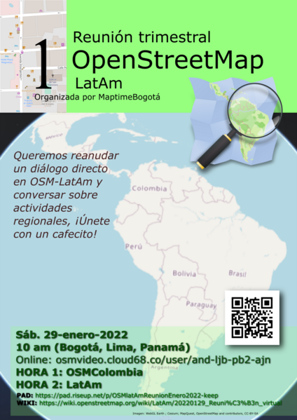
Estamos muy cerca de tener nuestra primera reunión trimestral latinoamericana de mapeadores en OpenStreetMap. Tú también puedes unirte sin importar si apenas empiezas a mapear o ya eres parte de una comunidad de ayuda de mapeo abierto.

En el wiki de MapTime Bogotá se muestran los detalles de la reunión para este sábado 29 de enero (dentro de dos semanas a la escritura de este post).

Invitacion