Users' Diaries

Recent diary entries

Posted by c tito young on 19 February 2021 in English. Last updated on 10 March 2021.

This 30m wide x 50m long geoglyph is an image that suggests a screaming, calling or yelling head wearing face makeup. Stark eyes faces right at viewer. This head is oriented north to south.

The artwork directed is of a head, that appears like it is calling or shouting. Stark eyes this geoglyph is quite large, almost completely hidden but fully exposed on a steep bluff that drops as much as 10m.

This geoglyph is located on a curve, right above a dirt road, possibly making it very hard to see. Approximately 300m to the north and a secondary group of geoglyphs exist as well.

15°18′12″S, 74°32′51″W -15.3032945, -74.5476281 Acarí, Province of Caravelí, Arequipa, Peru.

Location: Acarí, Province of Caravelí, Arequipa, Peru
Posted by c tito young on 19 February 2021 in English. Last updated on 12 March 2021.

An impression of north to south pointed head geoglyph 25m wide by 150m long is to the adjacent left of a geoglyph head 25m wide x 20m long. The geoglyphs appear close enough to touch each other. They are located on a at the same side of a 40m steep pitched hill.

The first is a pointy head geoglyph, shaped as a carrot, has distinctive two eyes and a mouth. There is little or no indication of a nose. There seems seem to be no indication of neck or body or extremities for this figure. The second is a smaller head has what appears to be two wide looking bugeyes, flat nose and a wide mouth and stops at the lower portion of its neck. There is no ears. The head was drawn just to the right of the carrot shaped head. The details are sketchy but the facial features appear intentional.

To the right of the smaller head are two geoglyph lines that may converge with another geoglyph line. While likely, it there is little confirmation from the satellite images to be certain.

Location: Acarí, Province of Caravelí, Arequipa, Peru

El concepto de área refiere a una superficie homogénea, continua y sin divisiones intermedias. En las zonas urbanas, residenciales, los espacios privados están separados por muros medianeros, por lo tanto la delimitación del contorno de las copas de un conjunto de árboles ubicados dentro de propiedades, separadas por muros, se presta a confusión, puesto que no existe un área continua. Por lo tanto, los árboles ubicados en zonas residenciales, donde es evidente la separación de las propiedades por muros, deberían marcase con un nodo, etiquetado con natural=tree. La etiqueta landcover=forest debería usarse para los parques o grandes extensiones, continuas, sin divisiones de muros o caminos, cubiertas por árboles. osm.wiki/ES:Bosque

Location: San Alberto, Cristo Rey, Posadas, Municipio de Posadas, Departamento Capital, Provincia de Misiones, Argentina
Posted by c tito young on 18 February 2021 in English. Last updated on 2 March 2021.

Several geoglyphs totals an area of 40m x 40m with a King figure 15m wide x 25m long and five different figures each averaging 5m x 5m. The orientation of these figures are north to south and from top to bottom changes elevation 10m. The image suggests a King figure centered and directly over his five subjects. Each of the faces have a lot of expression, though detail is very rough and will take some better backgrounds to fully understand.
The King has a wide faced head and the image suggests that his arms are folded in front of him. He is also suggested to have been wearing a crown. The five figures below him are as follows along with their descriptions. There are visible etchings that suggest bodies and possibly more faces, but they are unrecognizable. Therefore, unless there are more clear images, there is a degree of clarity in whether or not these five (or more) faces have bodies or necks. There is an attempt to show these figures.

Oval head (possible face to its right, possible shoulders and neck)
Triangle head (possible body below its head) Skull head (possible body below its head) Heart Shaped head (possible body below its head) Round face head (possible body below its head)

14°53′5″S, 74°52′59″W -14.8848281, -74.8831564 Vista Alegre, Province of Nasca, Ica, Peru

Location: Vista Alegre, Province of Nasca, Ica, Peru
Posted by c tito young on 18 February 2021 in English. Last updated on 10 March 2021.

Etched into a hillside is what appears to be a graphic of a 75m wide x 75m long geoglyph a joyous man, walking wearing a loose fitting v-neck alpaca pancho. He is pointing in front of him and behind him. He seems to be wearing a cap and a scarf. You can see two hands, two feet and facing the viewer and climbing the mountain. His oriented north to south and where he is etched changes elevation of a distance of around 15m;

14°53′19″S, 74°53′46″W -14.8885638, -74.8960171 Vista Alegre, Province of Nasca, Ica, Peru

Location: Vista Alegre, Province of Nasca, Ica, Peru
Posted by c tito young on 18 February 2021 in English. Last updated on 10 March 2021.

An etched geoglyph of the animal called a Capyvara (100m long x 80m wide) in an orientation of east facing west looks as if its eating from the ground. The animal, drawn anatomically correct has the side view unmistakably of the animal. From side view, two legs, head, one eye and body appears. The etching shows the animal while on all four legs, with its head to the ground, feeding. It is unclear what the animal is eating. There also seems little about what might be the reason for the artwork.

14°53′6″S, 74°53′25″W -14.8849783, -74.8901820 Vista Alegre, Province of Nasca, Ica, Peru

Location: Vista Alegre, Province of Nasca, Ica, Peru
Posted by pnorman on 17 February 2021 in English.

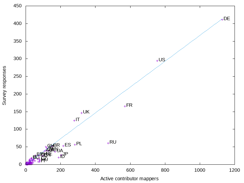
The board has started releasing results from their 2021 survey. I’ve done some analysis on the response rates by country.

There’s lots of data for activity on OSM by country, but for this I took the numbers from joost for how many “active contributors” there are according to the contributor fee waver criteria.

Preview image

For the larger countries, Russia is the most underrepresented country. This is not surprising, as they are underrepresented in other venues like the OSMF membership.

The US and UK are both slightly overrepresented in the survey, but less so than I would have expected based on other surveys and OSMF membership.

The smaller countries are all crowded, so I did a graph of just them.

See full entry

Posted by c tito young on 17 February 2021 in English. Last updated on 12 March 2021.

Multiple geoglyphs of less than 3m-5m can be seen nearby a huge 40m x 40m geoglyph of a cross with a 10m long horizontal line under it. From satellite it is impossible to read what they are clearly manmade shapes. This moderate slopes uphill from west to east and changes about 10m of elevation in 40m of distance. It seems possible that the large cross geoglyph is designed to be visible from one vantage points or other nearby distances.

14°53′14″S, 74°53′44″W -14.8872554, -74.8955639 Vista Alegre, Province of Nasca, Ica, Peru

Location: Vista Alegre, Province of Nasca, Ica, Peru
Posted by c tito young on 17 February 2021 in English. Last updated on 12 March 2021.

Geoglyphs ranging from 200m x 200m to 200m x 600m are of manmade continuous lines that when counting switchbacks easily stretch a distance of over 15000m. These linear geoglyphs lines average 1m in thickness, and also contain 180 degree switchbacks turns that might a single or double line. All the lines aim the similar direction, northeast to southwest and appear in three different sized groupings. The largest grouping has a smaller group within it. The three groups each with lines do not appear connected. Except for vantage points, every grouping of lines are etched in an entire area that is relatively flat.

The middle group, also the largest of the three switchback lines, have a semi-circular 10m diameter platform like geoglyph. This middle group also has what appears to be a ceremonial spot.

Each group of switchback lines have their own viewing/vantage point, where a small berm is provided. It is unclear what might be uses for these viewing/vantage points, but one might assume it is given importance. Each of the three viewing/vantage points all seem to be located northeast of the group of lines and all are approximately the same size. Coordinates are given to each and they are shown on the maps. It might be also worth noting the anything that was a hill may have been a vantage point, but the ones that were selected in coordinates seem to be the closest the the switchback lines.

No. 1 - Ancient Viewing Point -14.5995933, -75.3054811

No. 2. - Ancient Viewing Point -14.6026197, -75.3056850

No. 3 - Ancient Viewing Point -14.6080178, -75.3039053

14°36′21″S, 75°18′12″W -14.6058689, -75.3034485 Changuillo, Province of Nasca, Ica, Peru

Location: Changuillo, Province of Nasca, Ica, Peru

Located: 14°36′29″S, 75°17′10″W -14.6079702, -75.2859769 Changuillo, Province of Nasca, Ica, Peru

As one more into a westerly direction, the questions arise, how much did the Inca come this direction? Are there more as one nears the coast, or less.. do they follow a path? Is there a trail? Is there a change in technique? Were the ones in this area damaged by storms?

We shall see.

Moving the west direction away from Nasca, are there more lines? What is the farthest Nasca line? Why?

Location: Changuillo, Province of Nasca, Ica, Peru
Posted by c tito young on 16 February 2021 in English. Last updated on 17 April 2021.

Multi Linear geoglyphs between the distances of 1.5km and 4km must have been one of the greatest feat the Nasca Lines. In this relatively flat area, lines of 3km score this valleys landscape. Multiple scores reveal sixty separate side by side (5m apart) geoglyphs lines that are etched northeast to southeast in one direction and another twenty in east to west side by side 5m apart in another direction. These geoglyphs crisscross each other creating a massive X shape, that can been seen way up over the earth surface and that they seem to connect one plateau with another. More interestingly and with no real understanding quite why, some of the geoglyphic etchings are geometrically straight lines and others seem to allow deviances with curvature and angles. There are also places where lines drop off and others start Some of the lines tend to become groups within themselves, and thus they become their own shape.

As with other lines and shapes, found in regards to the Nazca Lines, the randomness is becoming more and more predicable. For example, just about every time the are drawing are drawn to point a something…

Cracking this code, as many before me have tried, might one of the following.

1) Getting noticed by Gods 2) Telling a story 3) Calendar 4) Star Charts 5) Indicators of sacredness 6) Mix of Ruins, Geoglyphs and Petroglyphs all in the same area.
7) All the lines aim or start from natural locations, lending more homage to star locations, or solar calendars.
8) Location of underground aquafers, underground streams 9) Possible indicators of property owned

Location: Changuillo, Province of Nasca, Ica, Peru
Posted by c tito young on 16 February 2021 in English. Last updated on 10 March 2021.

In this area a very foggy set of Geoglyph shapes of heads appeared in a row. Did not try to trace them, but just simply count what appeared as heads and circles. Decided to remove this entry. The shapes including some with eyes and mouth may have deciphered but not strong enough, in an area of 90m x 10m in an east to west direction in a rather flat valley. Extremely hard to see, decided to placeholder this for better sat images or delete. .

Awaiting better satellite images.

14°46′58″S, 75°10′21″W -14.7828406, -75.1724646 Nazca, Province of Nasca, Ica, 11401, Peru

,

Location: Nazca, Province of Nasca, Ica, 11401, Peru

Please noted Mentioned correct Address “Aziz Faizunnesa Tower”, Police Lines Road, Comilla 3500, Bangladesh

Location: পুলিশ লাইন্স, রেসকোর্স, কুমিল্লা, কুমিল্লা আদর্শ সদর উপজেলা, কুমিল্লা জেলা, চট্টগ্রাম বিভাগ, 3502, বাংলাদেশ
Posted by c tito young on 16 February 2021 in English. Last updated on 4 April 2021.

Two large monolithic 30m man made shapes appear side by side. One of the shapes resemble an oblong square with a trapezoid 5m x 5m box sticking out of it with multiple circular depressions with in it. The other shape appears to be a manmade modified geometric shape sticking with a roundish depression on its topside. Both these shapes appear to have some form of modification on them, but for what reason, it is unclear.

Location: El Ingenio, Province of Nasca, Ica, 11350, Peru
Posted by c tito young on 16 February 2021 in English. Last updated on 11 March 2021.

A geoglyph of a giant python snake (210m long x 10m wide) oriented west (head) to east (tail) and located at the top of a large flat hill appears to be slithering away. The sinuous shape of the snake makes an appearance of its body slithering along the ground. It is unclear the reason for this snake, but it could be assumed its direction points to the nearest manner in which to get to the sea.
At the bottom of the hill, to west is another geoglyph called “Gigante”. There are also a few geoglyph shapes at the foot of the hill towards the south.

Location: Nazca, Province of Nasca, Ica, 11401, Peru