Users' Diaries

Recent diary entries

Posted by apm-wa on 24 January 2021 in English.

The OSM Foundation Board of Directors needs your feedback on actions it took in 2020 plus your sentiments regarding controversial questions, and asks for some demographic data (optional) so we can understand better both the survey data and the structure of the community. Coincidentally, the survey is divided into “Feedback”, “Community Sentiment”, and “Demographic Data (optional)”.

After seven days, the OSMF 2021 Survey of the OSMverse has received 1,918 responses in total, of which 1,424 are “full” responses (that is, they include the optional demographic data).

A sum of 1,918 total responses means the survey features a 2.24% confidence interval at the 95% confidence level, and a 2.95% confidence interval at the 99% confidence level. The survey features a confidence interval under 3%! This is good validation of the sample, though I suspect it still suffers from a European and North American bias. Male respondents also dominate the sample quite heavily. Therefore: please spread the word, especially to colleagues in Africa, Asia, and Latin America, and to women and non-binary mappers! And data users! And software developers! And systems folks! Everyone in the OSM community!

We are shooting for a 2% confidence interval at the 95% confidence level, for which we need a minimum sample of 2,401 “full” respondents, and preferably they will be distributed geographically. Since about a quarter of respondents so far have declined to provide demographic data, this implies we need to hit 3,201 “total” responses or thereabouts.

See full entry

Posted by DW2515 on 24 January 2021 in English.

Who am I?

Hello, My name is Daniela Waltersdorfer, although in the OSM Community I’m known by some of you as Dani. I had the pleasure of serving as a OSMUS Board member for this past, and very difficult, year. I work in the Transportation Industry and run, with my awesome two co-hosts, Maptime Boston. In 2019 I joined in on the OSM US Code of Conduct Committee, developed to lead efforts to foster a diverse and inclusive OSM US community and this past 2020 we published the first ever OSMU US Code of Conduct (you can find more information here: osm.wiki/Foundation/Local_Chapters/United_States/Code_of_Conduct_Committee/OSM_US_Code_of_Conduct#OpenStreetMap_US_Code_of_Conduct )

Why am I running?

If you’d like to read my Manifesto for 2020, you can find it here: osm.org/user/DW2515/diary/392037 As you probably read, I am passionate about making this awesome community more welcoming, regardless of your technical skills. 2020 proved difficult to make these connections in-person- we didn’t have our beloved and biggest event of the year, State of the Map. However, although discouraging at times, this did not stop the Board in brainstorming with Maggie ways to increase grow our community. For more transparency, something I really value, I’ll share about my big expectation. I had hopes of creating a bigger connection between the transportation world and OSM US, especially with the private sector. You see, I work for a transportation consultant firm, meaning I work closely with cities, MPOs, States, and sometimes federal agencies in making transportation planning and engineering decisions. For various projects, OSM data has proven to be quite exquisite and impactful. So why not give back to this awesome project? Unfortunately, the pandemic slowed down some of my goals of creating a more connected community, especially when it comes to sponsorships and funding, for it has impacted many individuals and companies negatively in the economic realm.

See full entry

Posted by frizatch on 23 January 2021 in Abkhazian (Аҧсуа). Last updated on 24 January 2021.

Hello All!

I made my first edit to the map in 2016 when I discovered OpenStreetMap through a Maptime group which I now organize. I guiltily admit I was unaware membership was an option for some time and didn’t officially join until a little over a year ago. Although I have few changesets to my name (most come from demos while I’m teaching others), I’m an enthusiastic supporter of OSM because I understand the immense potential of this project.

I work in an academic library on an urban campus as geospatial support for students and faculty. Through my position at the University of Colorado Denver, and through the MaptimeMileHigh meetup group I run, I spend much of my time introducing OpenStreetMap to interested mappers and data users. I have led HOTOSM mapathons for students and the community at large to introduce the humanitarian value of this unique crowd-sourced information. I enjoy seeing traditional GIS students get excited when they realize there is an entire world of the geospatial technology they’ve been missing.

Serving on the OpenStreetMap-US board, I hope to expand the awareness of OSM to students, faculty and community leaders as they work together using public data for public good. Through academic frameworks such as the Data to Policy Project (d2p), for which I’m the student and faculty liaison, OSM can shine as support for policy development. With more diverse contributors to the map recruited via community outreach and academic programs similar to d2p, OSM can be better used for research and evidence-based advocacy. With more people from different sectors of society understanding they can contribute data to the global dataset that is OSM, the more representative and complete that dataset will be.

See full entry

Location: Denver, Colorado, Америка Еиду Аштатқәа
Posted by c tito young on 23 January 2021 in English. Last updated on 11 March 2021.

I may have proved a point. Elaborate geoglyphs equal elaborate ground etching and the two go side by side. To the southwest of the valley of the elongated heads is an array of geometry of accuracy that cannot be of chance. Lines tangent and alignments set up a series of geometry. More and more these geometries were created so that a culture can do anything and everything it can to appease gods for crop growing or better weather. Not always are these glyphs of recent times but rather it seems to be built upon each other through generations. Could it be a marking of success, or failure like the stock market? Could these represent navigation points? Could these lines be part of a machine? Could these lines point to shapes that tell a story? In some areas, shapes are surrounded by lines, some finished while others unfinished. There is some of the lines that obviously connect, and others that are close, near misses or that the terrain fails to give much clues as to what used to be there, and ALL seem intentional. .

2nd Entry:
How exciting to find additional geoglyphs to the east of the valley of the elongated heads. Finding it substantiates the overall importance that these glyph geometries are part of symbols that start to unlock the Nazca geometric efforts. I am taken by yet the fresh and very different types of lines and how the geometric shapes interlock. Surprisingly, I didn’t see them before, but as I am identifying each one by one, some of the line escape the other lines and shapes giving way to a brand new area. Are they doing this as a desperate way to save their crops or are they after something else. Why is the secret so difficult to understand? The more dive into these weird and obscure lines, knowing they have been created over a period of around 2000 years at least, the more questions they have. What is their secret? Why are they really doing this? Why is the geometry so precise?

Location: Santa Elena, Changuillo, Province of Nasca, Ica, Peru

Une connaissance cartographe m’a récemment transmis ce lien, d’un article daté de 2013 sur la cartographie participative et l’évolution récente de la cartographie en tant que discipline.

Il y a un paragraphe sur OpenStreetMap qui vaut la lecture. Et qui apporte sans doute un regard extérieur sur notre communauté (ce qui est rare). Voilà notamment un extrait:

“(…) le terme d’amateur peut difficilement être accolé au « mappeurs » d’OSM ! L’entreprise reste dominée par les développeurs informaticiens ou les geeks, passionnés du Web et des nouvelles technologies”

Même si l’accessibilité à OpenStreetMap s’est améliorée depuis 2013, je pense que ce jugement est toujours vrai. Bien sûr il y a probablement une majorité de contributeurs qui n’ont pas le profil “développeur” mais j’ai l’impression que plus les contributeurs sont impliqués dans OSM, plus ils correspondent à ce profil.

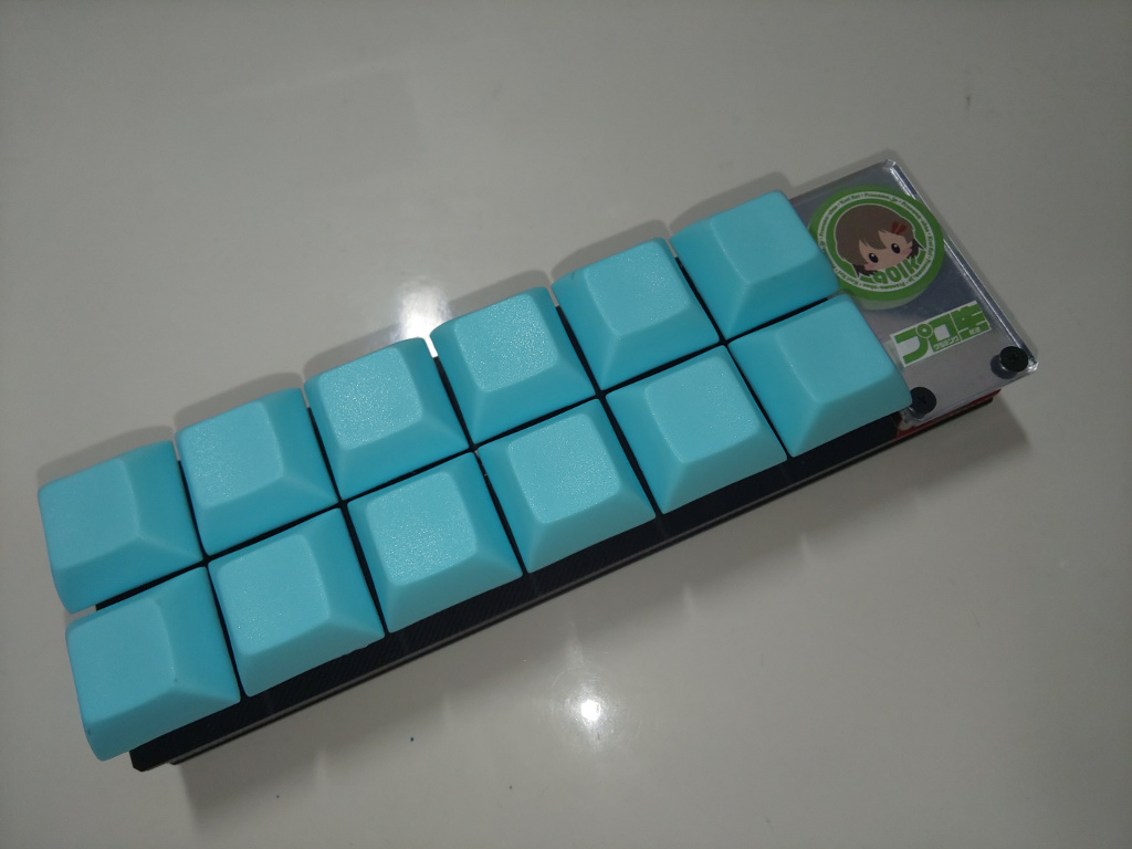
Mapbox has a document for using a gaming mouse to increase mapping. I build a custom keyboard and assigned JOSM’s shortcut keys, because unfortunately, I couldn’t find easy to use multi-featured trackball.

I built a keyboard is custom keyboard kit called “Dozen0” with 12 keys.

dozen0

The shortcuts assigned to the 12 keys are follow image.

See full entry

Kiel skribis Alan Mustard (prezidanto de OSMF) en sia taglibra afiŝo “The 2021 OSMF Survey of the OSM community has been activated”:

La enketo de OSMF al la OSM-a komunumo en la jaro 2021 estis “aktivigita” kaj nun estas respondebla ĝis la 14-a de Februaro (2021-02-14). Bonvolu retumi al https://osmf.limequery.org/281662 por aliĝi la enketon. Vi ricevos retmesaĝon kun unuope uzebla ĵetono (ligilo), per kiu vi povos partopreni la enketon.

La enketo haveblas en (ĝis nun) 16 lingvoj. Bonvolu konscii, ke la persa traduko estas tute (100%) maŝine-tradukita, pere de Microsoft Translator. Alan anticipa pardonpetas pri eraroj, ĉar ĝi estas lingvo, kiun li ne regas kaj li ne povis trovi tradukistojn por redakti kaj korekti la maŝina traduko. Kvankam verŝajne estas eraroj, li esperas, ke ne estu gravaj mistradukoj, kiuj iĝus la enketon neebla kompreni. Se vi povas helpi redakti la persan tradukon, bonvolu mesaĝu al li.

Bonvolu disvastigi tiun mesaĝon tra la tuta OSM-a komunumo – diskonigu! Bonvolu uzi viajn preferitajn komunikajn kanalojn por instigi ĉiujn en la OSM-a komunumo tutmonde partopreni ĉi tiun enketon! Alan (kaj mi) antaŭ-dankas vin pro tio.

Tovu en taglibra afiŝo “The 2021 OSMF Survey of the OSM community has been activated” de Alan ligilojn al la enketo en diversaj lingvoj. Ankaŭ eblas ŝanĝi la lingvo en la aliĝa paĝo https://osmf.limequery.org/281662 aŭ eĉ dum respondi la enketon.

Tre koran saluton, kaj feliĉan mapo-faradon!
Samideane,

Raphael (das-g)

بیتامدیکال عرضه کننده عمده کلیه تجهیزات مصرفی پزشکی آزمایشگاهی بصورت عمده و ارسال به سرتاسر کشور

Location: پرند, بخش مرکزی رباط کریم, شهرستان رباط کریم, استان تهران, ایران

بیتامدیکال عرضه کننده عمده کلیه تجهیزات مصرفی پزشکی آزمایشگاهی بصورت عمده و ارسال به سرتاسر کشور

Location: پرند, بخش مرکزی رباط کریم, شهرستان رباط کریم, استان تهران, ایران
Posted by apm-wa on 22 January 2021 in English.

At the moment, after 5-1/2 days, we have 1496 responses, of which 1116 are “full”, meaning they include demographic data that will allow us to do some cross-sectional analysis (almost 29% of respondents decline to provide demographic data). But keep spreading the word. We have 16 languages available: (English, Chinese (Traditional; Taiwan), French, German, Indonesian, Italian, Japanese, Korean, Persian, Polish, Portuguese (Brazilian), Russian, Spanish, Turkish, Ukrainian, Vietnamese). If you know of a group that needs another language and can link me with someone to translate the questionnaire, please do so! I have become adept at copying and pasting languages I don’t understand into Lime Survey.

We needed 1067 respondents to achieve a 3% error term at the 95% confidence level, but now I’d like for us to push for a 2% error term. As you all know, the larger the sample, the more accurate the estimates, and the wider we cast our net, the less the selection bias. For that we need 4160 respondents. We have three weeks left in the survey so it is possible if we continue to spread the word. Please help! The URL is https://osmf.limequery.org/281662 Please spread the word in whatever other languages you can, please encourage OSMers to participate, please use all available communication channels to reach as many corners of the OSMverse as you can!

Posted by c tito young on 22 January 2021 in English. Last updated on 23 January 2021.

I have been noticing the Nazca Lines and triangle shapes are generally “large, clear and easily” visible. I have been raising the questions on the lines that are small, old looking and barely visible. I think its for more important to record these before they get grown over or washed away, so I have been making a conscience effort in recoding them. One of the lines I placed down crossed the entire valley, but it wasn’t as clean looking as earlier lines. I think if its clear to you that these lines are visible, but old, worn or even tiny, record them.

I am still looking for patterns on these shapes. Its important to recognize the ends of the line point, aim or circle around.

The most important thing one can do on these Nazca lines is get them recorded.

Estou incluindo os nomes de Ruas de Cidades no Estado de Goias e Mato Grosso no Brasil, são ruas sem nomes e que precisa de nomes de rua, então estou fazendo essa atualização no mapa do Openstreetmap usando a camada de Nomes de Ruas disponivel para o brasil,

https://api.maptiler.com/maps/b2037b15-5614-4fed-9608-9830b8dc574a/256/{zoom}/{x}/{y}.png?key=YmPoUxbTlEHlrASzv56Z

atenciosamente,

Raphaelmirc

Recife/PE - Brasil.

I’m including the names of City Streets in the State of Goiás and Mato Grosso in Brazil, they are streets with no names and need street names, so I’m doing this update on the Openstreetmap map using a Street Names layer available for Brazil ,

Regards,

Raphaelmirc

Recife / PE - Brazil.

Posted by solenoid jam on 22 January 2021 in Russian (Русский). Last updated on 29 January 2021.

Год назад я загрузил в OSM первый трек с обхода, так что по поводу круглой даты хочется что то написать и запостить пару картинок. Сейчас у меня загружено 126 треков, но они, как и картография в целом являются лишь продолжением и развитием моего интереса к территории. Мое отношение OpenStreetMap довольно потребительское, я далек от волонтерства или жертвенности, просто любительская картография стала для меня обручем собирающим бочку в единое целое, точкой схождения нескольких интересов.

Первым интересом было исследование территории, подпитываемое в свою очередь краеведением и поездками на велосипеде. Территория это то пространство, которое ты обходишь, держишь в поле зрения, и негласно присваиваешь себе признавая своей. Думаю картография как нанесение знаков, является сублимированной формой того как метят свою территорию волки или другие животные. Собственно уже несколько лет я совершал прогулки с интересом исследования территории, картография же придала им систематический характер, и позволила произвести из них какой то материальный, стабильный во времени продукт.

Второе, это мой практический интерес к рисунку. Я недолюбливаю романтизм в искусстве, душевные порывы, и выдавливание чудных чувств из смычка или кисточки. Наоборот, мне интересно тупое, механическое следованию методу, натурализм и гиперреализм. Интересно отражение и преломление действительности, но всегда воспроизводимое, физическое, а не метафизическое, как открытый код в противовес “черному ящику” с мистическими спецэффектами.

Третьим мотивом стала семейная история - прадед был советским картографом, дневники которого попав мне в руки были прочитаны. Несмотря на скупость, они стали символическим приглашением в тему.

See full entry

Posted by bora can on 22 January 2021 in Turkish (Türkçe). Last updated on 7 October 2021.

Başta tahminen (“estimated”) çizilmiş olanlar olmak üzere, ülke sınırlarına ve daha önceden düzelttiğim yerlere dokunmadan il ve ilçe sınırlarını düzeltiyorum. Kaynak olarak Parsel Sorgu ekranını ve Atlas’taki MEGSİS katmanını esas alıyorum. (Bütün ilçeleri düzeltemeyebilirim)

Tamamen düzelttiklerim

Mutki-13

Kısmen düzelttiklerim

Ahlat-13, Güroymak-13, Merkez-13, Tatvan-13, Hasköy-49, Korkut-49, Merkez-49, Baykan-56, Kozluk-72, Sason-72

Dokunmayacağım iller

İstanbul, İzmir, Kayseri, Kocaeli

The NGO HOT US Inc organizes an election to replace one of its directors for a 6 months term.

Details of the election read on a wiki page

Below reads my electoral platform.

Summary

My OpenStreetMap journey is two fold. First, I co-founded the Humanitarian OpenStreetMap Team (HOT) concept in 2008, I co-founded of HOT US inc in 2010, I served the org as a Board member (2010-2014) and as its de facto Operations Manager for Haiti and Sub-Saharan Africa (2010-2013). Second, I co-founded the French associations Projet Espace OSM Francophone (ProjetEOF) and Les Libres Géographes (LLG) which supported technically and organizationally at grassroot level the growth of autonomous OSM collectives in Haiti and French-speaking Africa from 2014 to date. I developed a span of skills and experiences fit to serve 6 months at the HOT US Inc Board and help the organization in its willingness to reflect, change, localize, decentralize and implement its activities in a way more respectful of the OSM way and especially OSMF policies, jurisprudence and practices. Through the inner human, technical and organizational knowledge I had built over time in these Francophone countries whose language is, by the way, not currently represented at the Board, I think I can help the organization through its willingness to change described by Tyler by serving at its Board for the next 6 months.

Detailed version

Given the tight timeline for this election, this diary nots is work in progress and likely to be expanded at a later stage.

See full entry

Posted by TreeTracks on 21 January 2021 in English. Last updated on 30 January 2021.

UPDATE: Version 2 of the following draft was added to the Australian Tagging Guidelines on 30 Jan 2021. A short note and link to the Australian page was also added to the the international wiki highway=rest area.

The following notes provide a summary of comments on tagging roadside rest areas in Australia, based on a discussion on the OSM Australian mailing list in January 2021. Pending feedback on this draft, these notes will be incorporated into the Australian Tagging Guidelines and/or the international wiki highway=rest area.

Suggest adding a new section in the Australian Tagging Guidelines after the current section: ‘‘3.1.7 Tunnels and bridges and layers”, as follows.

Version 2: after comments received before 26 January

3.1.8 Roadside rest areas

A wide variety of rest areas are common on regional roads. Some parks on major roads in regional towns are signposted as rest areas. These parks are often managed by local councils rather than road boards and may be well used by local residents. These are best tagged using leisure=park (not highway=rest_area), name = “XXX Rest Area”. Features such as toilets and playgrounds can be added as separate features.

Roadside rest areas may be mapped using either a single node or a closed way (or area). Some small roadside stops directly adjacent to the roadway have been mapped using amenity=parking (with additional tags) rather than highway=rest_area. However, most roadside rest areas have been mapped using highway=rest_area, as described in the international wiki highway=rest area.

In larger rest areas, parking bays may be mapped separately to the broader boundaries of the rest area by mapping and tagging parking bays with amenity=parking. Alternatively, in small rest areas or where rest areas are mapped as a single node, both tags (highway=rest_area and amenity=parking) may be used on the same node.

See full entry