it is so much fun! and healthy ... i reanimated my bicycle and explore my neighbourhood like never before. so much details and so much to tag. and so much kilometers - i am in better shape now - mapping makes happy! :-)
Users' Diaries
Recent diary entries
Had some time on my hands today, so I started my contribution to openstreetmep.org by mapping the Papar river and adding detail to the west coast of Sabah, from the northern tip of Borneo down to the Brunei border.
My aim for the rest of this year will be to map the rest of the Sabah coast, its rivers and, hopefully, areas of mangrove forest.
Auf dem Heimweg von der Arbeit den Enzauenweg genauer gemapped und die unterschiedlichen Belagsarten erfasst. In Eutingen Enzstraße, Pfalzgrafenstraße, Am kühlen Grund und Reutestraße erfasst. Brömachweg in seine unterschiedlichen Bestandteile zerlegt.

Just a quick walk, adding some main points to bahnhofstrasse in Neufahrn b. Freising. I'll probably go there again tomorrow to collect a few more bits.
Anyone got any tips how to name the bus station and define the bus lines that are associated with it? Otherwise I'll follow the examples of the Underground stations in Munich.
Wollte eigentlich die A38 aktualisieren, einige Teilstrecken sind ja schon fertig, aber da war wohl jemand schneller.
Letztendlich kam dann nur eine kleine Straße in Canitz hinzu....
Added some trunklinks from exit 23 on N11 to ballycanew
Added some roads to Kilmuckridge
Added road from Wexford town to Ferrycarrig
Added some campsites from USFS gis data. Added and then removed some that were likely built from Google map data
http://lists.openstreetmap.org/pipermail/talk-us/2008-August/thread.html#331
Also added a few lakes. Draw one by hand in JOSM, than found the plugin to trace them and added a few more. Then found USFS water bodies data with even more detail but didn't get to it yet http://www.fs.fed.us/r6/data-library/gis/umpqua/metadata.shtml

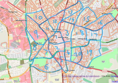
I'm pleased to announce that the cake is ready for the 17th London Mapping Marathon party, this time in Croydon, South London.
Croydon has excellent transport connections to London via the fast mainline link from Victoria to East Croydon.
The pub to meetup in afterwards has not yet been decided, but keep an eye on the wikipage.
Hope to see you there!
At last I made the tracks and notes from June into a seed of a map of Humpolec.
So, the last few days I added some cycleways in and around Zevenaar and today I tracked a few new cycle routes around the 'Balijbos' between Pijnacker and Zoetermeer. I'll add them to the OSM later today.
I started just a few days ago with editing the OSM maps but I just can't stop ;-)
Small problem between I-40 and this spot. The way and the Yahoo image match but my trace is off. It's possible that this is a section of divided highway that doesn't show in the image. Since I only travelled south along this section of US 93 and didn't take notes to show which parts are divided, I'll just skip ahead.
Ich bin mal die Bundesstraße 88 von Naumburg/Saale nach Ilmenau nachgegangen und habe dabei 89 mal die Bezeichnung B88 nach B 88 verbessert. Bitte an alle: den Artikel "an alle deutschen Mitarbeiter" weiter unten nochmal nachlesen!!!
So as well as doing a lot for Woolwich Royal Arsenal development, and (still to do) some around Greenwich, I checked out a village I know very well - Langham, north of Colchester, Essex (England). Put some missing roads/tracks in with aid of landsat imagery (and just knowing about where they should be, helps a lot when you're unsure whether a landsat jumble of pixels is anything solid or not!, and I do know the place well) and filled in many of the names that were missing and some big amenities.
Completed the section of US 93 that shares an alignment with I-40. Changed ref tags and marked a couple of bridges.
'Am Berg' in 'am Bach' umbenannt
(sorry, war mein Fehler)

:)

What is the difference?
I was trying to name some of the streets in my neighborhood when I noticed some inaccuracies in the traces. We have lots of little streets around here where the name are different on different sides of an intersection. So, the segment of a road north of York Mills Road is known as Sandover Drive, while the segment south of it is known as Valley Woods Drive. In OSM, these two streets are the same trace. Is there any way to create a break in the trace so that the two names may be assigned to the appropriate segments?
Die Arbeit am Dormagen-Projekt geht weiter: Gestern den gesamten Kern von Dormagen-Delhoven hinzugefügt, nur die Zersiedelungen, die an den Rändern ausfransen, fehlen noch. Die Tage davor das Gewerbegebiet Top-West eingepflegt, inklusive einiger Gebäude. Dormagen und Rheinfels sind schon vollständig, Zons (nicht von mit) hat den Anfang gemacht. Jetzt noch Richtung Norden Stürzekberg vervollständigen, sowie Nievenheim, Ückerath und Gohr und im Süden ist Hackenbroich auch noch nicht vollständig. Bei meinem Ehrgeiz, sämtliche Radverbindungen dabei mitzunehmen noch Beschäftigung für Wochen. Und dann kommen ja auch POIs, weitere große Gebäude und Landnutzungen...nur gut, dass es hier keine Straßenbahnen gibt, ich würde mich aufreiben...
I have done quite a lot of mapping around Svartedalen, north of Gothenburg, and Landvetter. It´s starting to appear on Osmarender, but it´ll take me another week or so to digitize most of the road network.