Users' Diaries

Recent diary entries

Este é o terceiro entre os diários de campo que compõem o caderno de campo da minha pesquisa sobre interações sociotécnicas nos Altos e Córregos da Zona Norte do Recife e sua área contígua em Olinda, cidades localizadas na Região Metropolitana do Recife (RMR). Mais detalhes sobre a pesquisa vocês podem ver na minha tese de doutorado, publicada em https://repositorio.ufpe.br/handle/123456789/48802. Para a tese a delimitação socioespacial foram os Altos e Córregos da Zona Norte do Recife, a parte de Olinda foi agregada depois da tese.

Os diários de campo foram realizados em minhas idas ao território objeto de estudo. Nessas idas sempre registrei o percurso com o aplicativo OSM Tracker. Esse diário diz repeito a ida para a sede do Maracatu Nação Estrela Brilhante do Recife, no Alto José do Pinho, Recife/PE http://u.osmfr.org/m/749769/ .

alt=track do percurso realizado neste campo

Segue abaixo o diário de campo na íntegra, apenas com alterações de nomes pessoais, com o intuito de resguardar a identidade das interlocutoras:

See full entry

Location: Mangabeira, Recife, Pernambuco, Região Nordeste, Brasil

Este é o segundo entre os diários de campo que compõem o caderno de campo da minha pesquisa sobre interações sociotécnicas nos Altos e Córregos da Zona Norte do Recife e sua área contígua em Olinda, cidades localizadas na Região Metropolitana do Recife (RMR). Mais detalhes sobre a pesquisa vocês podem ver na minha tese de doutorado, publicada em https://repositorio.ufpe.br/handle/123456789/48802. Para a tese a delimitação socioespacial foram os Altos e Córregos da Zona Norte do Recife, a parte de Olinda foi agregada depois da tese.

Os diários de campo foram realizados em minhas idas ao território objeto de estudo. Nessas idas sempre registrei o percurso com o aplicativo OSM Tracker. Esse diário fala sobre duas datas, pois no dia 22/03/2022 fui fazer uma entrevista e acabei gravando da entrada do Córrego do Jenipapo até o local da entrevista http://u.osmfr.org/m/735905/.

A ideia inicial seria andar pelo entorno, mas estava chovendo muito, além do meu interlocutor estar coordenando uma campanha de vacinação no dia. Assim, retornei no dia 07/04/2022 para circular pelo entorno do Córrego do Jenipapo e fazer registros fotográficos http://u.osmfr.org/m/744616/

See full entry

Location: Córrego do Jenipapo, Recife, Pernambuco, Região Nordeste, Brasil
Posted by nicyK20 on 7 June 2024 in English.

My name is NISENGWE Claudette and I go by nicyK20 in open street map. I joined OSM in March, it was in in ,mapathon organized by OSM Rwanda community to celebrate International women day. I saw a link in a WhatsApp group, I applied and they selected me. At time I didn’t know what mapping was, but they explained to us what they do and I became interested. I took their contact, they gave me more information. OSM Rwanda community is a very good community and I like how they make me feel included. much respect to its founder Rebecca and all mentors.

Location: Kabacuzi, Muhanga District, Southern Province, Rwanda

I found out Faqekuq is one of tens of villages surrounding my hometown, so I got excited. Faqekuq is a tiny village with a very small population and just a bunch of houses, so I proceeded mapping also the closest villages, Kapinovë and Turbohovë.

Kapinovë is a beautiful village and I have visited it many years ago when I was a teenager. I am so happy I got to add it to the map. To me, it is very important having this small, almost fully abandoned villages on the map because they should not be forgotten.

Movie suggestion: Bacurau

Sorry for the spoiler!!

One thing that hit me the most from this movie is that the government deleted the place for the map to make it disappear.

“#100VillagesIn100Days #Day7”

Introduction

My name is Lelio de Jesus Alves, and I am from Timor-Leste. I have been using OSM since 2022 and am currently participating in the OMGuru Fellowship 2024. I am excited to share my journey into open-mapping, what I find fascinating about the fellowship, my experiences, the lessons I have learned, and the impact it has had on me.

How I got involved with Open-Mapping

My journey into open-mapping began during my fourth year of university when I stumbled upon OpenStreetMap (OSM). Fascinated by the intersection of technology and geography, I joined an OSM workshop. The idea of contributing to a global, freely accessible map captivated me. I started by mapping my hometown, identifying missing roads, buildings, and other key features. This initial involvement opened doors to various mapping projects and eventually led me to apply for the Guru Fellowship.

Interesting/Fascinating about being the Guru Fellowship

What fascinates me most about the OMGuru Fellowship is the opportunity to connect with like-minded individuals who are equally passionate about mapping and geospatial technology. The fellowship is a unique platform that not only enhances my mapping skills but also connects me with a network of dedicated mappers and developers from around the world. One of the most fascinating aspects is the collaborative nature of the community. Despite geographical distances, we work together to improve the quality and coverage of OSM data. Ensuring data quality in OSM is particularly gratifying, as it enhances the map’s usability and builds user trust. This global collaboration embodies the spirit of open-source and community-driven projects, making it a truly enriching experience. By validating and improving data accuracy, I feel I am making a significant contribution to the global mapping community and supporting projects that rely on precise and dependable geographic information.

Define My experience as a Guru

See full entry

Location: Kampungbaru, Dom Aleixo, Dili, East Timor

OM Guru Journey

One of the best choices I’ve made in recent years was joining the Open Mapping Guru program initiated by the HOT Open Mapping Hub Asia Pacific. In 2024, I joined the validation track team. The challenges and tasks given each month are very interesting and help us, as OM Gurus, to make an impact on the community. So far, more than 300 tasks have been validated. However, that’s not all.

My Favorite Challenge

The OM Guru Climate Change Challenge is the peak of this year’s challenges, I must say. At first, I didn’t really pay much attention to the challenge since I saw many great teams out there ready for all the challenges. Until I saw a sub-challenge called the POI’s Mapping challenge. The best part is that for this challenge, I was only asked to map Points of Interest (POIs) in my area using local knowledge. Coincidentally, the area where I live, Bogor City and its surroundings, needed a significant data update. With my relatively high mobility in this area, I really used my local knowledge because I have almost passed through every corner of the city and some main roads I pass almost every week.

Surveying, Skating, Hanging Out

See full entry

Location: Ciwaringin, Bogor Tengah, Bogor, West Java, Java, 16124, Indonesia

Today I mapped the village of Gjerë. According to OSM data, the village has a population of around 400. The houses are scattered around the huge territory and around farmlands. I also expanded a little and mapped the surrounding areas.

“#100VillagesIn100Days #Day6”

Location: Gjerë, Poroçan, Bashkia Gramsh, Elbasan County, Central Albania, 3308, Albania
Posted by Spassk-dalnij on 6 June 2024 in Russian (Русский).

Родина — это не только власть, это страна, в которой мы живём, её земля и её народ!

Location: Спасск-Дальний, муниципальный округ Спасск-Дальний, Приморский край, Дальневосточный федеральный округ, Россия

The Generous Open Mapping-Data Quality Focused

Open mapping is a powerful tool for creating and sharing geographic data in a collaborative and open manner. Its benefits include increased data accuracy, improved data integration, and enhanced data visualization capabilities. However, it also has some limitations that need to be considered, such as data quality and security concerns. Open mapping has been instrumental in various initiatives, such as humanitarian aid, disaster response, and urban planning, and has become a vital resource for many organizations and individuals. While open mapping has many benefits, there are also some limitations to consider:

  1. Data Quality: Open mapping data may not always be accurate or up-to-date, as it relies on contributions from a community of volunteers.
  2. Data Integration: Open mapping data may not always be easily integrated with other data sources, as it may use different formats or standards.
  3. Data Security: Open mapping data may be vulnerable to security risks, as it is publicly available and can be accessed by anyone. Data quality is a critical aspect of open mapping initiatives. By understanding the challenges and implementing best practices, open mapping communities can improve data quality and ensure the accuracy and reliability of the data.

See full entry

Este é o primeiro entre os diários de campo que compõem o caderno de campo da minha pesquisa sobre interações sociotécnicas nos Altos e Córregos da Zona Norte do Recife e sua área contígua em Olinda, cidades localizadas na Região Metropolitana do Recife (RMR). Mais detalhes sobre a pesquisa vocês podem ver na minha tese de doutorado, publicada em https://repositorio.ufpe.br/handle/123456789/48802. Para a tese a delimitação socioespacial foram os Altos e Córregos da Zona Norte do Recife, a parte de Olinda foi agregada depois da tese.

Os diários de campo foram realizados em minhas idas ao território objeto de estudo. Nessas idas sempre registrei o percurso com o aplicativo OSM Tracker. Esses tracks eu coloquei no uMap, esse é o link do track deste diário de campo http://u.osmfr.org/m/1079569/. Embora quase sempre o OSM Tracker seja bastante preciso, nesse caso ele traçou uma linha bastante estranha, que não condiz com o percurso percorrido. Contudo, ele reproduziu as andanças no entorno da Rua Camboriú, local onde concentrei a maioria das informações.

See full entry

Location: Vasco da Gama, Recife, Pernambuco, Região Nordeste, Brasil

This diary entry is also available as a personal page on the OSM wiki.

Some History of GNIS Imports

GNIS is a database developed by USGS that contains information about the official, standardized names for geographic features in the US.

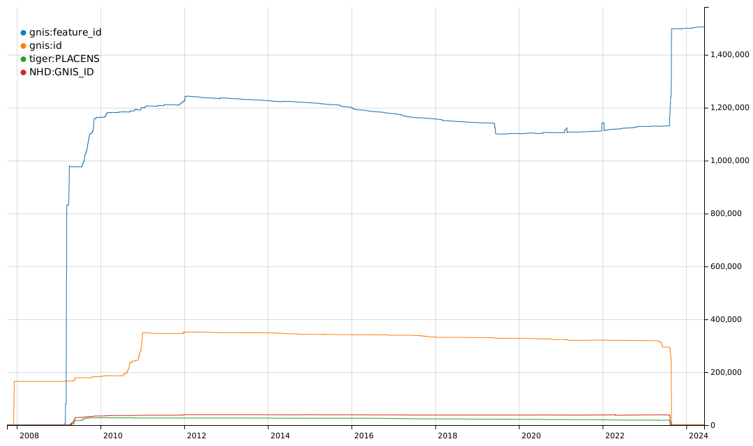
From 2008 to 2011, there was an effort to import basic data into the US map, including records from GNIS and records from TIGER and NHD that are cross-referenced to GNIS. You can see some of the history of these imports based on the tags they used.

Graph of the history of tags for GNIS Feature IDs

The gnis:feature_id tag was typically used for imports of many types of GNIS records. The gnis:id tag was used for imports of nodes for Populated Places, i.e. place=city, town, village, hamlet, etc. The tiger:PLACENS tag was used for imports of civil boundaries from the US Census Bureau datasets and contained a GNIS Feature ID value. The NHD:GNIS_ID tag was used for imports of waterways and other hydrographic features from the National Hydrography Dataset and also contained a GNIS Feature ID value.

See full entry

Posted by martin-kokos on 5 June 2024 in English.

OpenStreetMap is the project that picks where products that are driven by commercial incetives end. One of those areas is mapping the world also with respect to accessibility for people with disabilities. I’d like to talk about OSM for the blind (4).

Full text I’ve posted for the purpose of discussion to:
https://community.openstreetmap.org/t/more-osm-for-visually-impaired/114200

🌟 Calling all designers and creatives! 🎨✨

We’re on the hunt for the perfect logo for #SotMAsia24! 🌏✏️ If you’ve got a knack for design, we want YOU to paint the face of this year’s State of the Map Asia event in Cox’s Bazar, Bangladesh. 🇧🇩🗺️

Check out the details and submit your masterpiece by June 15th, 2024!

Check out the details here: osm.wiki/Call_for_Logo

Let’s make this year’s logo shine! 💫

Alt text

Today I mapped Përcëllesh which is a tiny village with a population of around 140. Since the village was very small, I expanded my mapping to the surrounding villages, and i also partially mapped the villages Kryezi and Gurrë.

“#100VillagesIn100Days #Day5”

Location: Përcëllesh, Petrelë, Tirana Municipality, Tirana County, Central Albania, 1034, Albania