OpenStreetMap logo OpenStreetMap

Users' Diaries

Recent diary entries

Posted by Cyberjuan on 9 April 2024 in Spanish (Español). Last updated on 10 April 2024.

 Tal como anunciamos en anterior post, seguimos informando a la comunidad OpenStreetMap LATAM sobre los comités del SOTM LATAM 2024, ahora les presentamos al Comité de Programación.

Este comité tiene como principales funciones:

  • Proponer la programación de actividades durante los días del SOTM
  • Diseñar las Actividades protocolares
  • Diseñar los Tracks del evento
  • Diseñar las Actividades paralelas
  • Diseñar las Actividades de recreación
  • Coordinar con los ponentes lo necesario para sus participaciones
  • Evaluar la realización de reconocimientos a los mapeadores de la región

Los miembros del comité son:

See full entry

Location: El Porvenir, La Oroya, Yauli, Junín, Perú
Posted by Cyberjuan on 9 April 2024 in English. Last updated on 10 April 2024.

 As we announced in the previous post, we continue to inform the OpenStreetMap LATAM community about the SOTM LATAM 2024 committees, and now we present the Academic Program Committee.

The main functions of this committee are:

  • Evaluate the presentation proposals received
  • Evaluate scholarship applications received
  • Management of travel and accommodation scholarships

As additional information for those interested in presenting a talk or presentation, the topics may be (but are not limited to):

See full entry

Location: Villa del Mar, Huanchaco, Province of Trujillo, La Libertad, 13013, Peru
Posted by Cyberjuan on 9 April 2024 in Spanish (Español). Last updated on 10 April 2024.

 Tal como anunciamos en el anterior post, seguimos informando a la comunidad OpenStreetMap LATAM sobre los comités del SOTM LATAM 2024, ahora les presentamos al Comité de Programa Académico.

Este comité tiene como principales funciones:

  • Evaluar las propuestas de ponencias recibidas
  • Evaluar las solicitudes de becas recibidas
  • Gestión de becas de viajes y alojamiento.

Como información adicional para quienes estén interesados en presentar una charla o ponencia, los temas de estas pueden ser (pero no están limitadas a):

See full entry

Location: -8.098, -79.075

Welcome to my fourth OpenStreetMap NextGen development diary.
Sorry for being a day late! I wanted to finish up one of the new features which caused this small delay. ✨

🔖 You can read my other development diaries here:
osm.org/user/NorthCrab/diary/

🐙 My work is available publicly on this GitHub repository:
https://github.com/Zaczero/openstreetmap-ng

GitHub stars counter

Let’s summarize the last week’s work:

Client-side Trace Images

While migrating the traces functionality, I came up with an amazing and seemingly obvious idea. Why not make trace images SVGs and render them client-sided? This feature has few significant advantages: even faster trace uploading, no additional disk usage, unlimited customization, infinite resolution, faster page loading. And so here it is:

See full entry

Posted by Eden Oluigbo on 8 April 2024 in English.

Not A Goodbye!

Two friends waving at each other

This is the Closing Chapter! However, the story continues😀

My friend (and colleague) Ola messaged me and asked, “Eden, how do you feel, that your internship at HOTOSM is ending soon?” I took a long pause to answer that 🥹.

As the curtains draw close on this chapter of my professional journey, I find myself reflecting on colourful experiences, lessons, and memories that have defined my time as an intern at HOTOSM.

It’s been 3 months already!?🥹 Like someone rightly said “time goes by quickly, when you are having fun”. I’m usually the type of person that looks forward to the end of a thing because I learnt to always finish what I started. But this time, it felt weird! A mix of nostalgia and anticipation.

See full entry

The situations described in this article are limited to Mainland China. The administrative divisions in Mainland China are very complex, and even for natives, it is difficult to understand them all at once. Therefore, please make sure you have a thorough understanding of the administrative divisions in Mainland China before editing relevant content.
参考:OSM Wiki China/Boundaries & Zh-hans:中华人民共和国#中国行政区划

(本文有若干内容是在发表后逐渐加入,若发现错漏或有任何疑问,恳请评论或发站内信指出)

本文旨在厘清中国大陆高度复杂的行政区划体系,并为希望完善相关数据的 OSM 贡献者们提供指引。本文所述内容及标注规范仅限于中国大陆地区(港澳台地区的情况请咨询相应社区),包含:

  • 法定行政区;
  • 非法定行政区;及
  • 标签的值与位置。

1 法定行政区

《中华人民共和国宪法》中有如下规定:

第三十条 中华人民共和国的行政区域划分如下:
(一)全国分为省、自治区、直辖市;
(二)省、自治区分为自治州、县、自治县、市;
(三)县、自治县分为乡、民族乡、镇。
直辖市和较大的市分为区、县。自治州分为县、自治县、市。
自治区、自治州、自治县都是民族自治地方。

1.1 含义

理论上来说,中国大陆的行政区划体系应该与如上规定一致。然而,几乎任何在中国大陆生活过的人都会立刻发现,这其中缺少了一个非常重要的概念:地级市。实际上,在法律法规资料库中,你几乎不可能找到「地级市」这个概念,在不得不提及时也会使用「设区市」或近义词。这是因为在实务中,地级市可能还管辖着县级市,而市不能下辖市,因此绝大多数县级市的名义都是「xx省直辖,xx市代管」(注1),不过通常可以将其视为仅由地级市管辖(但独立性相比县为强)。
此外,特区和林区(各自均仅有一例)作为历史遗留,也被承认为正式的县级行政区;部分民族自治区域也未写入法条。
因此,中国大陆的法定行政区如下表所示(注2):

行政区等级 行政区类型
省级 省、自治区、直辖市
地级 地级市、地区、盟、自治州
县级 县、自治县、县级市、旗、自治旗、市辖区、特区、林区
乡级 乡、民族乡、苏木、民族苏木、镇、街道
村级 (行政)村、牧委会、嘎查、社区

注1:部分县或县级市为「省直辖县级行政单位」,其不受地级单位管辖,行政区划代码第 3、4 位为特殊的 90,如湖北省仙桃市、河南省济源市、海南省临高县等。「省直辖县级行政单位」与「直筒子市」的区别在于名义上前者缺少地市一级,后者缺少区县一级

注2:根据《中华人民共和国民族区域自治法》第二条、第十二条,民族区()、民族镇()并非民族自治地方,目前一般将后两者视同普通区和镇。

1.2 标注等级

在关系 (relation) 中使用 admin_level,而在节点 (node) 上使用 capital。比如,一个县的关系中应有 admin_level=6,而该县的节点(place=city)上应有 capital=6。以下是各级行政区的标注等级:

行政区等级 admin_level/capital
省、自治区、直辖市 4
地级市、地区、盟、自治州 5
县、自治县、县级市、旗、自治旗、市辖区、特区、林区 6
乡、民族乡、苏木、民族苏木、镇、街道 8
(行政)村、牧委会、嘎查、社区 10

2 非法定行政区(「黑区」)

看起来,这套行政区划体系似乎非常清晰。然而理想是美好的,实际上,以下情况都存在:

See full entry

Posted by GovernorKeagan on 7 April 2024 in English.

Overview

Progress has been solid over the past week. My main focus is still trying to add in as many missing buildings as possible, but I’ve covered the following during the week:

  • Micromapping. While fixing two schools and two shopping centres, I decided to micromap them using a combination of aerial imagery and my local knowledge.

  • More buildings. I’m still just trying to “fill in the blanks” and get buildings added.

  • Small fixes. While doing other mapping, I came across various small issues that I fixed at the same time.

Micromapping

Schools

While updating some details for Victoria Park High School & Victoria Park Primary School, I decided to micromap them while fixing some misalignments. I tried to map in a way that makes sense and not just to make it look pretty on the renderer.

While doing this, I noticed that the park next to the High School had some seemingly strange boundaries. I need to do some more research to confirm where the park boundaries lie, so for now it remains the same.

Shopping Centres

Similar to how I started with the schools, I wanted to correct some details and fix some “wonky” mapping from older imagery. I ended up doing some pretty detailed micromapping except for changing some shop details - I know that they aren’t there any more, but I don’t have the current shop details at the moment.

More Buildings

I’m very happy with the progress that I’ve made. It’s slow at times, but it is moving and I can see the difference. There has been a decent amount of properties that had a node with address but no area mapped for the building. This has come in handy once or twice where I could verify the building to ensure that it is still there, which wasn’t always the case.

Having said that, it would still be great for a local to confirm all of this, there’s only so much I can do from Ireland.

Small Fixes

See full entry

Location: Nelson Mandela Bay Ward 3, Nelson Mandela Bay Metropolitan Municipality, Eastern Cape, South Africa

IVIDES.org® realizou oficina sobre POI


O Instituto Virtual para o Desenvolvimento Sustentável promoveu uma oficina sobre mapeamento colaborativo de pontos de interesse (POI) com OpenStreetMap.

O conteúdo abrangeu os pontos de interesse mais utilizados e um diferencial, o mapeamento dos pontos costeiros e marinhos, que são frequentemente negligenciados nas palestras e cursos sobre o assunto.

Todos os arquivos da apresentação podem ser encontrados no portal do treinamento, que inclui também a agenda dos demais encontros.

https://ivides.org/oficinas-mapeamento-openstreetmap

https://ivides.org/wp-content/uploads/2024/04/capa_video.png

A gravação da sessão pode ser encontrada no canal do IVIDES.org® no YouTube.

See full entry

Posted by PineappleSkip on 6 April 2024 in English. Last updated on 11 April 2024.

Guidance missing for Queensland

There is no clear indication on the Australian Tagging Guidelines/Roads about how Queensland Roads should be classified according to a national hierarchy.

This diary note is about rural roads. I live in a smallish country town and there are few urban roads that aren’t covered by the rural roads hierarchy

Classification and tagging in Australia

The primary guidance appears to be the comprehensive Victorian classification, which classified roads as M, A, B, C or D, or unclassified, with M, A, B and C routes signed. These are to be tagged as Motorway, Trunk, Primary, Secondary and Tertiary.

Victoria, Tasmania and South Australia sign C roads (with the exception of a handful of South Australian Roads) and the extent of the classifications varies by State or Territory. NSW only signs A and B roads.

NSW classification and tagging.

NSW is significant to Queensland classification as the primary traffic interface to Queensland is NSW. Traffic into South Australia and the Northern Terrirory is negligible by comparison.

NSW readily corresponds to Victoria at the top levels with M, A and B roads as corresponding to the Victorian Hierarchy.

The NSW Roads Act 1993 specifies an elaborate classification, but tagging is based on simplified NSW Main Road classifications at the B and below level. The two categories are State Roads and Regional Roads. 1. State Roads, which are largely A and B roads but include some others (e.g. Byrock to Brewarrina, Tumut to Tumbarumba) which are unnumbered. (as noted above M and A roads are tagged as higher in the hierarchy). 2. Regional Roads, which appear to be the balance of NSW Main Roads.

For Openstreetmap, NSW State Roads, whether signed as B or not, are tagged as primary roads. Regional Roads are tagged as secondary roads. There is a clear source for contributors in this Official Map of classified roads

Suggested Queensland classification

See full entry

感謝 TomTom 台灣辦公室 ê 牽成,由𪜶公司成大測量系系友去接接,閣加上 OpenStreetMap Taiwan ū 申請社群的 Tasking Manager 管理權限,會當新增適合本地進行 ê 專案,才有這改 ê 機會去成大進行 OpenStreetMap 圖客工作坊,並且用 Tasking Manager 來分配繪製台灣本地 ê 圖資。

Tasking Manager 
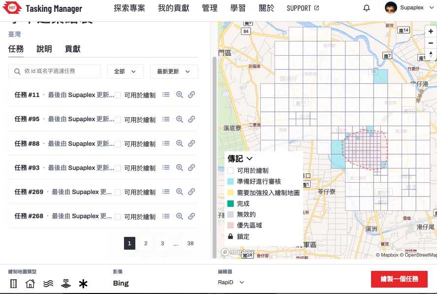
▲ Tasking Manager ê 專案,這改 boeh 繪製 ê 範圍-台南學甲區

這改成大圖客松 3/26 為止攏總 ū 107 个編輯變動,29 个 sī 工作人員 ê 編輯變動,3 个社群朋友 ê 編輯變動,22 位學生投入編輯總共 ū 75 个編輯變動,設定繪製 ê 目標建築,總共畫出 369 棟。

學生家己動手了後,投入 ê 狀況猶袂䆀,頭起先紹介𪜶 OpenStreetMap ê 基礎智識,閣來予𪜶知影資料 boeh 按怎產生–ê,落尾家己動手來做。毋過整體時間干焦一个半點鐘,其實時間無夠用,除非抵著比較庄腳 ê 任務,正常來講可能一塊當中 ê 建築攏畫袂完。

這改邀請方 sī 成大測量系,佮老師話仙時,𪜶定定 teh 運用 OpenStreetMap 資料,老師和社群部分 sī 熟似早年 ê OpenStreetMap 台灣社群走跳 ê Dongpo,因此 OpenStreetMap 相關 ê 智識 sī tuì Dongpo 來–ê,嘛是真合理 ê 代誌,因為 Dongpo 嘛是空間資訊學科背景 ê 人。

See full entry

Location: 大學里, 東區, 三份仔, 臺南市, 701, 臺灣
Posted by Cyberjuan on 5 April 2024 in English. Last updated on 10 April 2024.

 It is with great excitement that we present to you the Organizing Committee of the SotM LATAM 2024 which will take place in Belem, Brazil, from December 6 to 8 of this year.

This volunteer committee has, among others, the functions that the SotM Working Group assumes in the global SotM, that is, mainly:

  • seeking a host location,
  • arranging sponsorship,
  • organising the detail of the conference,
  • promoting the conference, and
  • running the conference.

This committee is made up of those who, at the last AbreLatam 2023 in Montevideo, Uruguay, had the initial idea of holding the SotM Latam together with the FOSS4G 2024 that was announced at said event. Other map enthusiasts have been joining this initial group, contributing different visions and perspectives that we are sure will enrich SOTM LATAM 2024.

See full entry

Location: Mario Rivera, Yavari, Province of Mariscal Ramón Castilla, Loreto, Peru

Presentation of the Organizing Committee of SOTM LATAM 2024 in Brazil. Amazônia, Belém - Pará Brazil

It is with great excitement that we introduce you to the Organization Committee of SotM LATAM 2024 that will take place in Belén, Brazil, from December 6 to 8 of this year.

It is with great excitement that we introduce you to the Organization Committee of SotM LATAM 2024 that will take place in Belén, Brazil, from December 6 to 8 of this year.

This volunteer committee has, among others, the functions that the SotM Working Group assumes in the global SotM, that is, mainly:

See full entry

Location: Marco, Belém, Região Geográfica Imediata de Belém, Região Geográfica Intermediária de Belém, Pará, North Region, Brazil