Users' Diaries

Recent diary entries

My Sotm Brazil 2023 conference, an incredible experience and a lot of knowledge about Brazilian projects

Foto do Sotm 2023 Brasil

O State of the Map Brasil 2023 aconteceu no Centro Politécnico da Universidade Federal do Paraná, na cidade de Curitiba, Paraná, Brasil, entre os dias 02 e 04 de outubro de 2023, em formato híbrido.

As Palestras podem ser vista no canal do Youtube.

Canal do Youtube - State of the map Brasil 2023

See full entry

Location: Jardim das Américas, Curitiba, Paraná, South Region, Brazil
Posted by Kamil Kalata on 20 October 2023 in Polish (Polski). Last updated on 6 April 2026.

Dzień dobry.

Planuję dodać informacje o ograniczeniach prędkości w Zwoleniu i okolicach (±5 km). Mam zamiar rozłożyć tę pracę na co najmniej kilka etapów, w tym niżej wymienione:

Lp. Miejsce Wykonanie
1. Ulice Reja i Kościuszki (bez strefy zamieszkania) ✅ (142877077)
2. Podzagajnik (wzdłuż drogi krajowej nr 12) ✅ (143217369)
3. Ulica Targowa (między ulicami Wojska Polskiego a Majora Hubala) ✅ (143625723)
4. Ulica Żeromskiego ✅ (143827509)
5. Ulica Armii Krajowej (między stacją paliw Orlen a ulicą Żeromskiego) ✅ (143876925)
6. Ulica Ludowa ✅ (143933627)
7. Ulica Mickiewicza ✅ (144143894)
8. Ulice Świętej Anny i Świętego Jana ✅ (144174370)
9. Aleja Pokoju (między ulicami Skłodowskiej-Curie a Kochanowskiego)
oraz ulica Skłodowskiej-Curie
✅ (144219978)
10. Plac Kochanowskiego (bez drogi krajowej nr 12),
ulica Kościuszki i Aleja Pokoju (obie w strefie zamieszkania),
ulice Jagiełły, Krakowska, Moniuszki, 3 Maja,
ulica Kilińskiego (między placem Kochanowskiego a ulicą Kochanowskiego)
✅ (144448565)
11. Ulice Generała Andersa, 550-lecia, Czachowskiego,
ulica Graniczna (między ulicami Targową a Czachowskiego),
ulice Cielątki, Wężyka, Mała, Miła, Wesoła, Gotardowa, Dobra,
ulica Prosta (między ulicami Czachowskiego a Wesołą)
✅ (144506747)
12. Ulica Szkolna i Bulwar Targowy ✅ (145661789)
13. Ulice Bogusza i Księdza Packa ✅ (155317760)
14. Ulice Kardynała Wyszyńskiego, Kościelna, Różana, Staropuławska, Lubelska, Chopina,
ulica Słowackiego (między ulicami Kardynała Wyszyńskiego a Chopina)
✅ (180959087)

Dalsze etapy będą podawane w miarę postępu prac.

See full entry

Location: Praga, Zwoleń, gmina Zwoleń, powiat zwoleński, województwo mazowieckie, 26-700, Polska

My reflection on the SotM Nigeria 2023 conference, lots of experience gained, meeting new people, learning new skills and sharing knowledge about OpenStreetMap, Open source data, local community inclusion and a lot more about the geospatial industry in Nigeria and the globe were incredible and amazing. regardless of challenges pose we overcame and conference was a success.

Lesson Learnt: The SotM 2023 has triggered my passion for OpenStreetMap volunteerism, local community inclusion & development and humanitarian response to open mapping, it has connected me to geospatial experts from different location of Nigeria and across, indeed it was privilege to meet with Mentors geospatial industry, each bit of conversation was an opportunity for learning, inspiring and collaboration for me.

Knowledge Gained: the knowledge gain was really mind – blowing. presentation made by different participants, were absolutely inspiring, well-tailored. With the likes Prof. Joseph Oloukoi, (AfriGist), Maron Mikel (OSM foundation), Letwin Pondo (SciStarter), Geoffrey Ketaregga (HOT Community project Lead) and others presenters has deepened the knowledge of open mapping and local community inclusion.

Challenge pose: Inadequate fund to support the conference was the major challenge of SotM 2023 conference, which has disbalance the logistical planning and other arrangement but I saw resilience, commitment, tirelessness of the Local organizing committee towards the success of the conference.

Future Hope SotM 2024: I look forward to SotM 2024 regardless of financial constraints posed at SotM 2023, that will not underscore relevant of open mapping and geospatial infrastructure in Nigeria. I believe in collaborative efforts of all individuals, as I was fortunate to witness the commitment and tireless effort of the organizing team, I look forward to SotM 2024, were we all work, meet and share knowledge and the trending happening of Open source and geospatial field.

See full entry

Location: Galadimawa Village, Municipal Area Council, Federal Capital Territory, 900104, Nigeria

Hi, I am Mahjabin, a undergrad student from Computer Science and Engineering Background from Eastern University. Additionally, I am the President of YouthMappers at Eastern University, Bangladesh. Through this chapter, I have came to know about OSM like two years ago, but I mainly focused on working with the existing map data for project by using Python or simply saying geocoding. I guess I got a practical experience why mapping in OSM is very much necessary as much as using the data, because when working with disaster management projects, I faced a lack of data in my area so I have started making small edits in my free time as well as working map data because my main focus is in that. I hope to contribute to OSM or open data overall as much as I can.

Posted by cyrusyg_ on 20 October 2023 in English.

UNIQUE MAPPER A Poem by Cyrus Aladja

Growing up and coming into age Really never belonged, truly felt different Like a bird, free to roam never in a cage Now it’s dawn I clearly see and here’s the difference

It strange nor weird, oh this bird is no freak It’s long overdue, this bird is no longer shy Maybe by chance it hatched in a pen with chicks But it’s time now to take its place in the sky

High up in the clouds to see the world and conquer Coasts to coasts, nations to nations, city to city all therein Cause now all eyes can see this bird’s a wonder Flying on Eagle’s wings, with grace and so so serene

Now it’s clear, the bird is unique Created and formed by our maker A bird high in the clouds is unique! This bird is a unique mapper

Location: NEPA, Port-Harcourt, Rivers State, 520052, Nigeria

Just a few short weeks ago I made the decision to map all house numbers in Lancaster. Of course, I understood what an undertaking this is, so I set off on a search for good ways to view and add this data. Ultimately, I found myself at Lancaster’s GIS Website. After consultation with the OSM discord, I considered it safe for use and began to map them by hand using JOSM.

This leads me to why I personally believe house numbers to be so important. Through personal experience, I would consider house-to-house navigation far more used than routing to a business. If a map has no house numbers, then that may rule a large number of people completely unable to use such a map. This is why I seek to map house numbers.

After about a month’s time of mapping (plus life getting in the way) I would say I’m about 5% done. Slow progress, but progress nonetheless!

If any others would like to join my mission for mapping Lancaster’s addresses, it would be much appreciated!

Location: Lancaster, Los Angeles County, California, United States
Posted by aaei924 on 19 October 2023 in Korean (한국어). Last updated on 11 July 2025.

도로의 분류 기준


현실의 국가에서

일반적으로 도로의 위계를 구분함에 있어서는, 해당 도로가 연결하는 지역의 성질을 기준으로 하고 있습니다.

  1. 여러 도 혹은 국가적으로 중요한 지점 사이를 잇는 도로 (국도에 대응)
  2. 여러 시/군 사이를 잇는 도로 (지방도에 대응)
  3. 여러 읍/면 사이를 잇는 도로 (시/군/구도에 대응)
  4. 하나의 읍/면 내에서 여러 동/리 사이를 잇는 도로
  5. 하나의 동/리 내부를 잇는 도로

이런 식의 지역 단위를 기준으로 한 분류 체계는 일제강점기부터 오늘날 남북한에서까지 이용되고 있는 유서 깊은 방식입니다. 그만큼 검증되고 확실한 분류 체계라는 의미도 될 수 있습니다.

도시계획시설 기준에 관한 규칙 제9조제3호에 따른 기능상의 구분으로는 아래와 같습니다. 어느 도로가 어디 해당하는지에 대한 구체적인 정보는 vworld 등에서 도시계획도로 정보를 참고하면 확인할 수 있습니다.

  • 주간선도로
  • 보조간선도로
  • 집산도로
  • 국지도로

일반적으로 주간선도로에서 보조간선도로가, 보조간선도로에서 집산도로가, 집산도로에서 국지도로가 분기되는 구조를 가지고 있습니다.

오픈스트리트맵에서

현재 OSM에서 통용되는 한국 지역의 편집 기준은 아래와 같습니다. (아래의 주요/비주요 도로는 iD편집기 상 카테고리입니다.)

  • 주요 도로
    • 1차: 국도
    • 2차: 지방도
    • 3차: 시/군도
  • 비주요 도로
    • 주거: 주거 구역을 연결하는 도로
    • 주택가: 거리 구역/마을 안의 길
    • 미분류: 마을 등을 잇는 샛길, 임도와 유사함
    • 트랙: 관리 도로(농로/임로)
    • 서비스: 시설 내부 접근 도로/진입로 등

현 체계의 문제점


비주요 도로 분류 기준의 불명확성

현재 비주요 도로는 주요 도로에 비해 분류 기준의 명확성이 떨어지는 상태입니다. 명확성이 주요 도로에 비해 상대적으로 떨어지는 것은 어쩔 수 없으나, 가능한 한 명확한 기준을 세울 필요가 있어 보입니다.

주거, 미분류 도로의 잘못된 기준

현재의 기준을 보면 주거 도로는 주거 구역을 이어주며, 주거 구역 바깥의 길로 설명하고 있습니다. 하지만 영문판 위키의 태그 설명을 참고해 보면, 원 의미가 ‘마을을 연결하는 기능이 없는 주거지로의 접근을 목적으로 하는 도로’입니다.

Roads which serve as an access to housing, without function of connecting settlements.

  • 영문 위키의 설명 -

즉, 현재 한국에서의 ‘주거 도로’ 기준은 원래의 개념과 완전히 다른 것을 가리키고 있습니다. 주거 구역 바깥을 이어 주는 도로는 오히려 ‘미분류 도로’(unclassified)가 적절합니다.

미분류 도로의 경우, 원래 한국에서 사용되지 않았던 것으로 보이지만, 한국의 분류 기준 설명에서는 주택가 도로와 트랙 사이에 있는 것으로 설명하고 있습니다. 하지만 highway 태그의 설명을 보면, unclassified는 tertiary의 바로 다음 단계입니다. 원래 미분류 도로가 가리켜야 하는 것은 작은 규모(마을보다 크고 도시보다 작음)의 지역 내부를 이어 주는 도로이지만, 현행의 체계는 이것을 ’주거 도로‘로 태그하라고 안내하고 있습니다. 물론 마을 등을 잇는 샛길이라는 현재의 특성은 이 기준에서 벗어나지 않지만, 위계가 잘못 정해져 주거 도로의 분류가 우선되고 있는 현재의 상황은 문제가 있다고 생각합니다.

특정 지역에서 지역적 특성에 기반하여 구체적인 기준을 정하는 경우에는, 그 기준이 원래의 개념과 체계 전체에 비추어 보았을 때 괴리가 가급적 없어야 합니다. 그런 점에서 현재의 기준은, 가장 기본적인 위계조차 잘못 설정되어 있다는 점에서 개선이 요구됩니다.

trunk 태그에 대한 오해석

See full entry

Posted by Matt_ on 19 October 2023 in English.

I pulled together some info I wanted to share: what is the longest connected group of untouched TIGER imported roadways in the U.S.? The answer is this 1258.6km group of ways in Brooks County, Texas. And then below will be the rest of the info I found. I haven’t done anything with it, I just wanted to share.

Note: the Overpass queries I link directly to are all relatively quick since they’re just lists of way IDs. But for some of them I link to pastebin since they were too long to pass in a url.

Overpass Turbo - Brooks County, TX Results from Brooks County, Texas

Idea

The full results are here as a spreadsheet but I also want to explain.

I was looking at the results of the query for unedited ways and nodes in an area near me and noticed there were way more untouched roads than I thought there would be.

See full entry

Posted by James_OWORNTE on 19 October 2023 in English.

Sotm Nigeria 2023 Abuja was very very impactful to me. Especially, having the privilege to present a topic titled ‘The Role Of Open Street Map On Emergency response. I want to use this opportunity to say thank you to all our sponsors for paving way for some volunteers who could not afford it to the conference physically, by giving grant which I also benefited from it. I’m looking forward to mapping more using open street maps and having more opportunities to participate in conferences and events coming up in the merest future. Once again I say thank you, I really do appreciate. 🙏

Posted by gvwaal on 18 October 2023 in English.

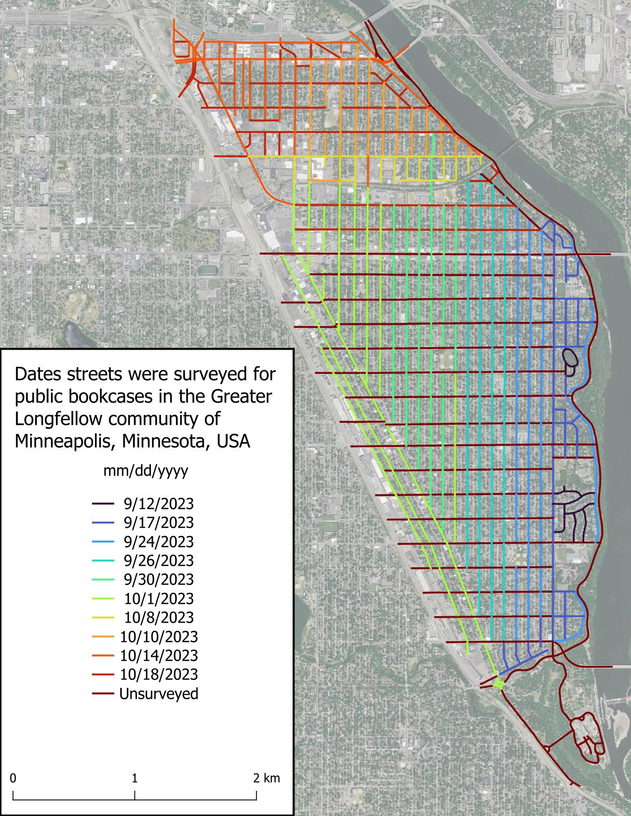
All* of Seward is surveyed! I found very few public bookcases (PBs) when surveying the remaining streets, which wasn’t surprising because most people put their PB in their front yard, and in Minneapolis, most front yards are on the avenues (north-south roads).

*It’s possible there are PBs in the entryways or at the base of large apartment complexes, and I didn’t attempt to circumnavigate each large apartment as that would have involved leaving the street.

Intro

Part 2

Part 3

Figure displaying dates roads were surveyed in the scope area. Roads are colored based on date, with the earliest date, 2023-09-12, in very dark blue and grading to red for unsurveyed roads.

It’s another previllage and opportunity to the part of local organizing committee (LOC) beand community volunteers and also selected as travel grantee to attend the hybrid state of the Map conference in Abuja Nigeria. collaborations with national research and development agency (NARSDA). It was very inspiring moment and knowledge shared was super amazing. I’m getting so much interesting In researching with geospatial tools after the presentation of #Afrigis, #cartoscope and #scistarter and Geoffrey keganttera presentation on food production system in Uganda was very educative . And also discussed more about technical support to local community members of open street Map foundation and sponsorship. I’ll like to appreciate the west and North African hub(WNH) for there special support to unique Mappers . (Afrigist)(URL) *##@{Alt picture}URL

Location: Kyayya, Barde, Jema'A, Kaduna State, Nigeria

It’s another previllage and opportunity to the part of local organizing committee (LOC) beand community volunteers and also selected as travel grantee to attend the hybrid state of the Map conference in Abuja Nigeria. collaborations with national research and development agency (NARSDA). It was very inspiring moment and knowledge shared was super amazing. I’m getting so much interesting In researching with geospatial tools after the presentation of #Afrigis, #cartoscope and #scistarter and Geoffrey keganttera presentation on food production system in Uganda was very educative . And also discussed more about technical support to local community members of open street Map foundation and sponsorship. I’ll like to appreciate the west and North African hub(WNH) for there special support to unique Mappers . (Text)(URL

Location: Kyayya, Barde, Jema'A, Kaduna State, Nigeria

It was indeed a great privilege attending the SOTM Nigeria 2023 conference in Abuja, at the Obasanjo Space Centre.

I was also a participant last year at the maiden edition of the SOTM conference 2022 in Port Harcourt. This participation aroused my interest and I have not looked back ever since. This year my very good friend and sister Hopeful Bafamodei invited me to be a part of the panel that talked about the cultural perception of genital mutilation. Thereafter my co panelist shared how mapping is needed to get data from areas identified as code red, where genital mutilation is being practised and how with the use of these data collected, help can come to such communities. Right there we had a live participant who shared her experience of what she had to go through in the hands of her very own father. I want to appreciate most importantly Dr Victor Sunday and all the LOC who made this event possible, The presentations made by Ian Tobia, Makcron, Eromosele and Hopeful, thought me one thing…….RESILIENCE. My passion for this conference is growing by the day and I am looking forward to more engaging content to be discussed during future events.