 OpenStreetMap

Iniciamos no setor de Geoprocessamento da Prefeitura Municipal de Jaraguá do Sul a 12 meses atrás a migração e sobreposição no OSM das edificações através do JOSM - Editor Java do Openstreetmap de 72.678 edificações que recebemos a partir da restituição aerofotogramétrica contratada pelo município de Jaraguá do Sul em março de 2020. Iniciamos esse trabalho de atualização na área central da cidade e avançamos para atingir todos os 38 bairros e as 15 localidades rurais que compõe o Município. Para esse trabalho contamos também com a participação de vários Bolsistas e estagiários de Engenharia Civil e Arquitetura que desenvolveram também essa atividade durante o tempo que estiveram no setor de Geoprocessamento. Outro editor que também foi usado com bastante frequência foi o Editor iD - Editor no navegador web do OSM utilizado para demais atualizações como número de edificações e seus vários tipos de usos, etc. Queria deixar registrado que as ferramentas mais usadas no JOS após a importação das edificações em blocos foi o plug coloured streets para colorir as edificações com números já existentes no OSM, facilitando o uso da ferramenta Substituir Geometrias, e da configuração de seleção de nós e tags. Também utilizamos no JOS a URL de configuração de serviço TMS/XYZ:https://www.jaraguadosul.sc.gov.br/geo/ortomosaico2020/{z}/{x}/{y}.png mosaico de ortofotos da mesma contratação citada acima. É Importante salientar que essa base atualizada tem grande importância para o Município de Jaraguá do Sul por fazer parte da página inicial do Geoportal do Município que pode ser visualizado no seguinte endereço https://sistemas.jaraguadosul.sc.gov.br/index.php?class=GeoMapView. Agradecemos também o apoio e as dicas do Engenheiro Helio C. Tomio do setor de parcelamento de solos na concretização desse trabalho.
Users' Diaries
Recent diary entries

The Sahrawi Arab Democratic Republic does not exist in the annals of the United Nations, please remove it from the map.
A casa do cimento queimado em Ribeirão Preto Rua João Penteado, 576

Cartography is an artform. Besides being used for art, it is a practice rooted in subjectivity. For most people, it may be only a means of navigation, but any cartographer acknowledges that they make decisions based on their own opinions when making maps. OpenStreetMap is one of the more objective maps out there, but it’s still not always clear how to map things. As a community, we’ve had to make numerous decisions on the “best” way to map something. Sometimes, we don’t have a singular answer. Users of OpenStreetMap data must interpret these decisions as best they can. Tagging is usually what comes to mind when considering what comes into dispute here, but scope is important as well. And this is where privacy comes in.
Privacy status quo
We have some privacy standards. Besides GDPR compliance, the Data Working Group redacts edits that introduce personal information, such as annotations intended for an individual that may link their account to a real person. It generally isn’t acceptable to map features inside private residences either, like rooms or toilets. These may come as common sense to most, but others still could have counterpoints. The level of detail most are comfortable with is what is visible from street level or the sky. I think this is a good standard, but some are still left uncomfortable. There’s the occasional new mapper who deletes driveways leading to single-family homes. It may not even be their own driveway, but some may be unfamiliar with OpenStreetMap’s tagging system that makes it clear when a driveway is private and that it is, indeed, a driveway. One cannot fault a person for wanting privacy; the concern then is about damaging data (digital vandalism). At least where OpenStreetMap is based, there is no law against making a map of someone else’s property. Legal concerns about cartography are a separate matter not related to individual privacy, which is my focus here.

Ho imparato ad aggiungere punti con l’applicazione OSMAnd, molto utile. Grazie a @Ysogo

0
Ruta circular que parte de Aso de Sobremonte , para pasar por Betès antes de comenzar la subida. Subida que primero nos llevará a Punta Cerruza , luego ya vamos recorriendo las numerosas Puntas que rodean este Valle, Punta Faceras , Burrumbalo , Sarrataclau , Peñas de Aso, Balposata, Canales….y acabamos en el Monte Lucas donde iniciamos el descenso. Desde las distintas puntas y picos hay magnificas vistas al Vignemale, la sierra de Tendereña, Macizo de Argualas etc. La ruta no tiene complicación. La pongo moderada por la distancia y el desnivel. osm.org/user/fsopena/traces/4324177

fir and fine
This is a possible site: SA Property and Planning Atlas. However (I now see) there is no copyright notice displayed - so best use the other explicitly CC licenced sites offered by the SA government.
I got tired of adding addresses to hundreds of houses, so reluctantly decided to research custom presets. What a pleasure it turned out to be - I recommend it. Here is all it took:
<?xml version="1.0" encoding="UTF-8"?>

<!--
* Put this file in ~/snap/josm/common/  [This is specific to Ubuntu Linux]
* Add to JOSM by selecting  Edit / Preferences / Tagging Presets
* and then press '+' on the top-right, then specify the path to this file.
-->

<presets
  author="xrisnik"
  version="1.0"
  shortdescription="Presets File"
  description="Setting residential building and address in JOSM">

  <item name="Residence + address" type="closedway">

    <label text="Edit"/>

    <space />

    <combo key="building" text="Residence type" values="detached,terrace,semidetached_house,apartments" display_values="Detached,Terrace,Semi,Apartments" default="detached"/>

    <text key="addr:housenumber" text="Number" default="" delete_if_empty="true"/>

    <text key="addr:street" text="Street" default="" delete_if_empty="true"/>

    <space />

  </item>

</presets>

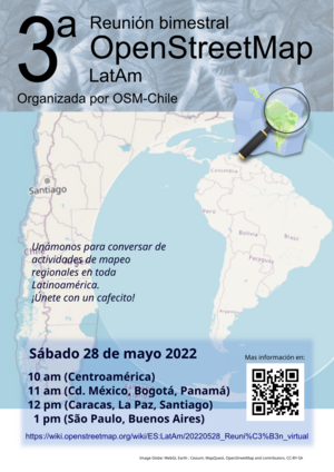
Estamos muy cerca de tener nuestra primera tercera reunión bimestral latinoamericana de mapeadores en OpenStreetMap. Será virtual y tú también puedes unirte sin importar si apenas empiezas a mapear o ya eres parte de una comunidad de ayuda de mapeo abierto.
En el wiki de OSM Chile se muestran los detalles de la reunión para este sábado 28 de mayo de 2022.
Hi This is my location
Hey world! I’m Osinachi and this is my first diary entry. I am a beginner mapper and the map my village campaign is the first project I am engaging in. I have found it really exciting for the five days I’ve mapped so far. I am thrilled by the opportunity to make my village globally accessible. I have been able to map a lot of buildings so far with the ID editor. As magnificent as it has been, I have also encountered some issues with the images. I will really appreciate it if they were clearer but all in all, it’s been great. I hope you all will contact me if there are any campaigns. I enjoy doing volunteer activities. They make me feel like my life has been worth living. Thanks so much for this space OSM! Happy mapping

Найчастішим запитанням, з яким до мене звертаються різні перехожі – «як пройти за якоюсь адресою» та «який це номер під’їзду». Іноді складність пошуку правильного під’їзду можна спостерігати серед працівників служб доставки. Одна справа – знати тільки свій район, інша справа – охопити знаннями декілька міст.
Потреба в швидкому пошуку того чи іншого під’їзду має велике значення в різноманітних сферах: нерухомість, служби доставки, екстрені служби (швидка, пожежна, газова), таксі, поштові служби. Це може бути навіть корисно безпосередньо вам, коли ви йдете в гості до когось.
Так, бізнес має можливість створювати для власних потреб необхідні додатки для демонстрації потрібних даних. Єдине, це питання у підтримці окремого софту, його наповненні та актуалізації. А зважаючи на світові коливання останніх років (COVID-19, військові дії, кризи) – ринок потрібних додатків може швидко змінюватися, старі компанії зникають, з’являються нові і так нескінченно.
Тому довіру викликають відкриті продукти, які на ринку вже багато років і являють собою агрегатори різноманітних геопросторових даних. І чим детальніший і глибший кожен шар даних – тим краще і точніше. Особливо це стосується так званої «останньої милі».
І саме входи до будівель, номери під’їздів багатоквартирних будинків, перелік квартир в кожному під’їзді є одними з найзапитуваніших даних останніх років. Тож їх потреба у використанні неминуча.
Основним інструментом та агрегатором різноманітних геопросторових даних для потреб мікромапінгу є OpenStreetMap. Будучи відкритою платформою майже будь-яких даних та відповідаючи трьом основним критеріям даних «імпорт/експорт/відтворення» - все більше користувачів звертають увагу саме на OSM.
В даному випадку входи, під’їзди та їх нумерація не стали винятком для використання. І їх поява – це лише питання часу.
Загалом в Україні нанесено на OSM 30243 під’їзди (входи) до будинків у вигляді точок.
Декілька основних міст по кількості:

Opening up streetlevel imagery
With OpenStreetMap Belgium and our umbrella Open Knowledge Belgium, we have been lobbying to get governments to collect their street level imagery in the open.
While there are many projects to collect images, almost allways the government does not retain ownership of the imagery. Instead of paying for data collection, they pay for access to the data. This means the price is low for the individual governement organization, but in our complicated political landscape of federal, regional, provincial, intercommunal, or communal organizations, many are buying access individually. In the end, the total cost for the tax payer is higher, without there being any open products that can benefit the rest of society.
We believe payment for the data collection should happen only once, and ownership of the imagery should be transferred to the government. This would result in the lowest cost overal. By releasing the imagery as open data, its value for society is increased even more. Access to extra services can incentivise governements to pay up for the base data collection.
Slow progress
While the intercommunal organization WVI (Dutch text) has contributed open 360° imagery for most of the industrial areas in West-Flanders, and three Flemish municipalities have shared 360° imagery taken by Vansteelandt, the vast majority of projects that we hear about do not result in open data.
This is why in 2022 we are launching the Open StreetLevel Imagery Project. We are scaling up our efforts to crowdsource open street level imagery at a low cost. We are investing a very small budget which we expect to have a significant impact.
The OpenStreetMap Belgium role

Opening up streetlevel imagery
With OpenStreetMap Belgium and our umbrella Open Knowledge Belgium, we have been lobbying to get governments to collect their street level imagery in the open.
While there are many projects to collect images, almost allways the government does not retain ownership of the imagery. Instead of paying for data collection, they pay for access to the data. This means the price is low for the individual governement organization, but in our complicated political landscape of federal, regional, provincial, intercommunal, or communal organizations, many are buying access individually. In the end, the total cost for the tax payer is higher, without there being any open products that can benefit the rest of society.
We believe payment for the data collection should happen only once, and ownership of the imagery should be transferred to the government. This would result in the lowest cost overal. By releasing the imagery as open data, its value for society is increased even more. Access to extra services can incentivise governements to pay up for the base data collection.
Slow progress
While the intercommunal organization WVI (Dutch text) has contributed open 360° imagery for most of the industrial areas in West-Flanders, and three Flemish municipalities have shared 360° imagery taken by Vansteelandt, the vast majority of projects that we hear about do not result in open data.
This is why in 2022 we are launching the Open StreetLevel Imagery Project. We are scaling up our efforts to crowdsource open street level imagery at a low cost. We are investing a very small budget which we expect to have a significant impact.
The OpenStreetMap Belgium role
How to add live tracking, or just live updates of pin positions while traveling and wanting to share my experiences through the map.

зміню ті міста де ніхто ними не займається


It was amazing and exiting to have our Unique mappers community joining again for the 1-week Mapathon Webinar #mapmyvillage . Good to have Raph-the HOT Global Validation Team lead joining us to handle the validation training room.And thanks to Kingsely and Chiosm Okwuchi for amazing job in the beginners room and advance mappers room. We had maore participants joining to learn how to map thier villages in OSM