Users' Diaries

Recent diary entries

If you want to import OpenStreetMap data to PostgreSQL (+ PostGIS) database two popular tools are osm2pgsql and imposm3.

Both were designed to prepare data for rendering although some time ago osm2pgsql was upgraded with scripting capabilities that go beyond simple mapping files that specify what tables to create and what objects should be inserted there (filter by tags).

There is also osmosis if you want a - more or less - copy of OpenStreetMap database.

imposm3 development was put on hold due to lack of funding while osm2pgsql is actively developed. This makes it questionable choice to use imposm3 but it does have some nice qualities that can make it better for some projects.

In my opinion it’s a very good tool that is useful when:

  • you have a webapp and want to use OSM data but Overpass API is too slow/limited
  • you want to use OSM data for spatial analysis and keep it updated

** The rest is of the text including instructions how to import data is in my github page: https://ttomasz.github.io/2022-04-08/osm-import-data-with-imposm **

Posted by jmapb on 8 April 2022 in English. Last updated on 29 May 2023.

[continued from part 1]

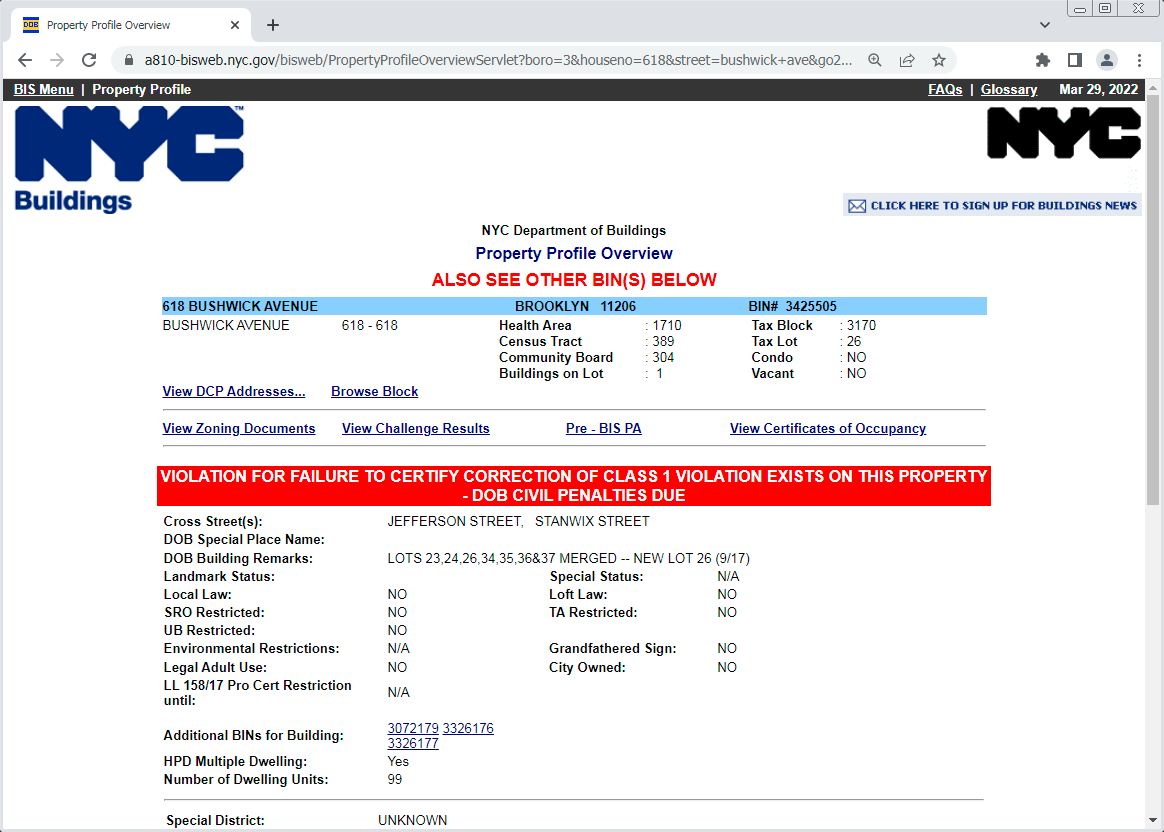
Carrying on with my Brooklyn survey… In the Bushwick neighborhood, I’ve found another new building to map, and a good opportunity to show a little more of NYC’s Building Information Search tool (aka BIS.). Like last time, we’ll start by finding the building’s BIN and height using BIS’s search option 1, with borough Brooklyn, housenumber 618, and street Bushwick Avenue. Here’s the resulting Property Profile Overview page:

BIS Property Profile Overview of 618 Bushwick Avenue

(That exciting red bar means this development is currently in trouble with the Dept of Buildings, but that’s none of my business.) We find the BIN, 3425505. Note the “ALSO SEE OTHER BIN(S) BELOW” message and the “Additional BINs for Building” field – these are older obsolete BINs that this new building has supplanted. The “DOB Building Remarks” note about multiple lots being merged tells the same story, which is a very familiar one in Brooklyn: A large new building has replaced several smaller buildings.

See full entry

Location: Brooklyn, Kings County, New York, United States

Hi all,

MapComplete has been (partially) translated in 21 languages by now - an amazing feat that I could never have done alone (for starters, I don’t speak 21 languages).

(For those that don’t know MapComplete - it is an easy-to-use map viewer and map editor. It shows POI on the map and when clicking something, shows the known information and asks questions about it)

Translating MapComplete started by manually editing the translation files, making a pull request, … A next step was moving over to Weblate, where there is more support for translations.

However, one has to know where to find this translations and translating can be tricky, figuring out which piece of text goes where.

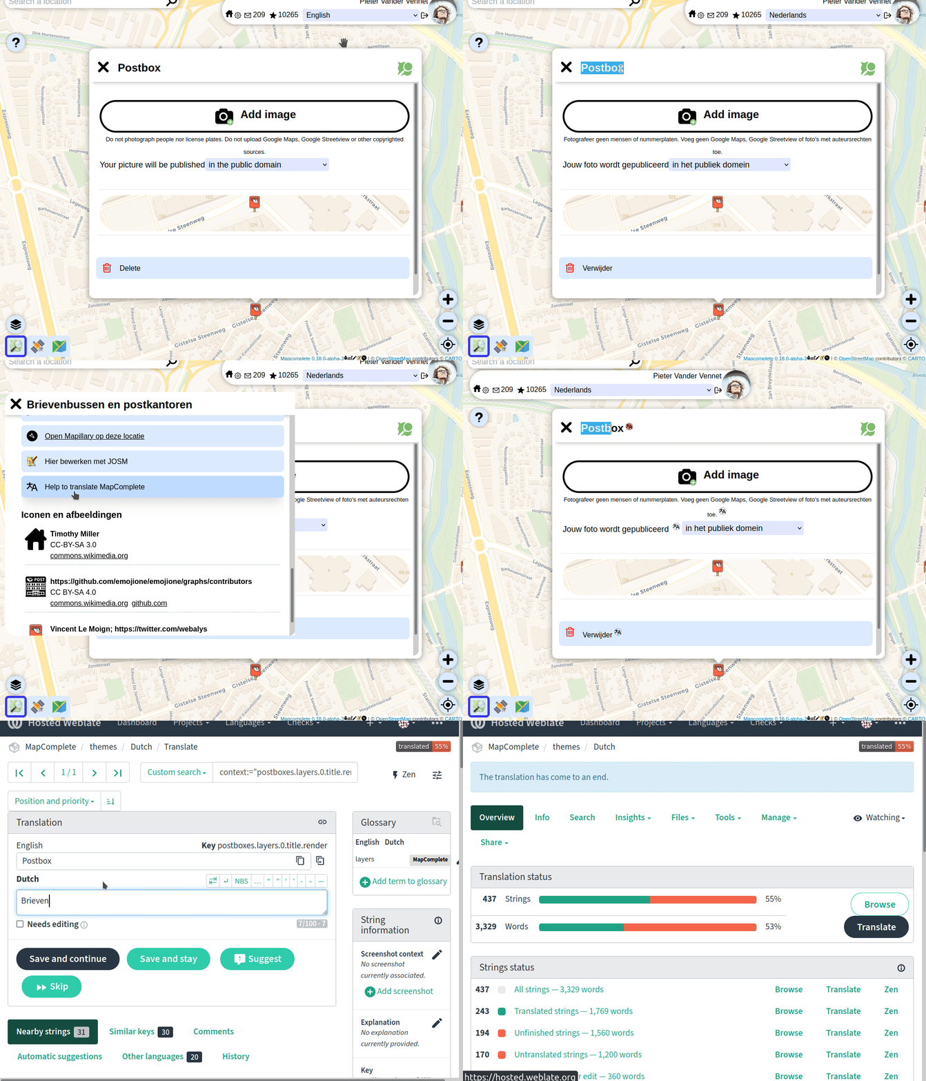
That is why I launched a new feature today: toggling ‘translators mode’ (in the copyright tab) will add little buttons, taking you directly to the page to translate the string (or to fix some typos):

So: please help to translate MapComplete in your favourite language!

Some remarks:

See full entry

Обращение к сообществу OSM и к его участникам!

Россия вероломно напала на Украину 24 февраля 2022 года, нанося ракетно-бомбовые удары по аэропортам, воинским частям и объектам гражданской инфраструктуры. Это явилось очередной эскалацией военных действий, начавшихся в 2014 году с момента захвата Крыма и частичной оккупации Донецкой и Луганской областей.

Мы, сообщество OSM Украина, в связи с продолжающимся военным вторжением России на территорию Украины обращаемся к людям, которые вносят свой вклад в развитие и улучшение данных OSM.

Мы призываем всех воздержаться от какого-либо маппинга на территории Украины в данный момент!

Российско-украинская война идет на многих фронтах, в том числе и на информационном. Возможное использование российскими захватчиками открытых данных для планирования атак на военные и гражданские объекты является одной из важнейших причин, по которой мы просим не предпринимать каких-либо действий по маппингу объектов на территории Украины.

В случае обнаружения случаев маппинга, касающегося военных объектов или объектов критической социальной инфраструктуры, мы будем их корректировать (удалять, видоизменять, откатывать к предыдущему состоянию и т.д.), а также обращаться в DWG и в другие рабочие группы OSMF для блокирования участников, которые систематически вносят подобные изменения (больше одного).

Такая просьба (требование) перекликается с положениями статьи 114-2 Криминального кодекса Украины, согласно которой “Распространение информации о перемещении, движении или расположении Вооруженных Сил Украины или других образованных в соответствии с законами Украины военных формирований, при возможности их идентификации на местности, если такая информация не размещалась в открытом доступе Генеральным штабом Вооруженных Сил Украины, совершенное в условиях военного или чрезвычайного положения, наказывается лишением свободы на срок от пяти до восьми лет” (https://zakon.rada.gov.ua/laws/show/2160-20#n10).

Posted by w_wie_waldi on 7 April 2022 in German (Deutsch).

Vorwort

In diesem Blog möchte ich ein paar Worte über das Mapping von inoffiziellen Radwegen verlieren. Gemeint sind nicht beschilderte Radverkehrsanlagen (z.B. durch das blaue Schild mit weißen Fahrrad), sondern Wege und abgetrennte oder nicht abgetrennte Bürgersteige besonders außerorts.

Ich bin relativ neu hier in der OSM Community und bin durch eine Projektarbeit zur Kartografierung von Radwegen relativ schnell auf das Problem des Mappings im Allgemeinen und das von Radwegen und Bürgersteigen im Speziellen gestoßen. In diesem Post möchte ich ein paar Gedanken zum Mappping hinsichtlich verschiedener Aspekte aufführen, welche vielleicht die Diskussion bezüglich verschiedener Mappingmethoden in neue Richtungen lenken kann.

Problem

Path

Eine in meiner Umgegend verbreitete Variante, unbeschilderte von Radfahrern vielbefahrene Wege zu labeln, ist “highway=path” mit “foot=designated” und “bicycle=designated”. Dieses Mapping mag zwar akzeptiert sein und die Realität abbilden. Jedoch führt dies in meinen Augen zu einigen Problemen. Zum einen verliert das Label “designated” seine ursprüngliche Bedeutung. Die Alternative mit “bicycle/access=official” scheint mir nur eine umständliche Lösung dazu zu sein.

Außerorts

Ein weiteres Problem besteht darin, dass viele Radwege an urbanen tertiären Straßen verlaufen und damit vom Prinzip her baulich getrennte Bürgersteige sind, welche nicht explizit für Radfahrer freigegeben sind. Dennoch werden solche Wege gut von Radfahrern benutzt, sind in vielen Radkarten zu finden und haben daher teils Radfahrstreifen-ähnliche Kreuzungsmarkierungen. Diese ausschließlich als Bürgersteige zu markieren wäre ein Verlust für das Fahrradnetz, diese aber als “designated” zu bezeichnen ist aufgrund fehlender Beschilderung meiner Meinung nach nicht möglich.

Innerorts und Parks

See full entry

Posted by Skunkman56 on 6 April 2022 in English.

I am really glad Cad-Man are rendering- WC still seems to have a problem. I did have it as administrative boundary for a bit with the admin_level tag, but I think the admin_level tag was throwing me off- that tag seems to be specific in the US for certain values (=6), regions(=5), etc. Scrubbing the admin_level tag seems to help.

There are still a few national forests kicking around with the boundary=national_park tag to clean up, and there are probably national parks mapped as such that have private inholdings within them not depicted- only the outer boundary is mapped. Case in point, though not a national park, is Adirondack Park- osm.org/relation/1695394. Adirondack Park is a stretch since there is no national designation for that, unlike National Forests and National Parks. I agree the green line render is a bit much if we used the boundary=national_park tag, and the consensus from the mailing lists seems to be a strict literal interpretation of national “park”, if anything to keep people getting confused- best to stay conservative with the interpretation.

I also made some progress on the Mackinaw State Forest - Gaylord Unit late yesterday and should be done with that one. Then back to fix up the Lake Superior State Forest units. The fix for Tahquamenon Falls State Park seems to be rendering when zoomed in. The Newberry Unit is rendering also- osm.org/relation/13993909. Shingleton and Sault Ste. Marie still seem to have problems. I would have liked to move on to the Pere Marquette but a little detour to the UP was a nice change.

When I was a kid, my dad relied on an over-sized atlas depicting roads, towns, public lands, lakes and streams at the county level. He used this on road-trips, consulting it while exploring to determine if uncertain just which way to go. Signs were important- the signs marking the corners of state game areas. Road signs. County boundary signs. They were a navigational aid. When I got old enough, he gave me my own atlas. By that time however, the internet provided a bevy of informational maps at much smaller scale- letter-size maps showing individual public lands, trail maps, and much more. Updated and more accurate than the old atlas often based on commercial data sources and the 24,000-scale series of USGS topographic quadrangle maps. Today, we can make our own paper maps using online mapping applications, consult a digital map on a cellular-connected smartphone pocket computer or wristband computer, create our own spatial data using high-accuracy GNSS or heads-up digitizing from remotely sensed products, or even contribute to the public world-wide map of OpenStreetMap. There are so many options in this new digital environment to explore and find uses for. It’s wonderful today when we still have our over-sized paper atlas or folded maps available at any outdoors store, but also so many more options to access, create, and share maps. So whether you have a paper map in your pocket, or a mobile remote connection to the world-wide digital map, or a window onto the world from your home computer, I hope you find great experiences exploring and learning more about the world.

I have no answer as to whether it is useful. Now I am not talking about real benefits, but about intentions

They did nothing useful for Ukraine map before. They do not worry, about OSM data, even if they talk about it. They want the Russian army to do the same to us as in Bucha. They are passive supporters of Putin. I think that such guys have no place in OSM

https://community.openstreetmap.org/t/country-based-authorizations/838

تحية طيبة ورمضان كريم بمساعدتكم ببعض المعلومات وفهمكم للبرنامج اريد تعلم المزيد من الخبرات وذلك لهوايتي بالسفر والولع بالبرنامج وتواجدي في مناطق صحراوية وطرق خارجية حدودية وذلك بحكم عملي للاستفادة منها واساهم في تعميم الفائدة لجميع من حولي بتعليمهم اساسيات برامج الملاحة والخرائط 🌷🌷مع تحياتي زميلكم علي.

Posted by Skunkman56 on 5 April 2022 in English.

The ways representing the Manistee and Cadillac ranger districts now are split out into separate relations. For the Manistee National Forest super-relation, I added a way to represent the administrative Forest boundary, snapped to the adjacent outer edges of the ownership ways. This gives some geometry for the relation when you search for and pull it up. To avoid confusion over actual ownership/extent of protected_area / leisure=nature_preserve, I scrubbed those from the Manistee relation and they are only on the district subarea relations. Manistee is tagged boundary=administrative, the subareas tagged boundary=protected_area. We will see how the tagging savants respond to this strategy. I did add an admin_level=6, the equivalent of the county level, to help show the Manistee admin boundary at a wide zoom level. Maybe it will work. I thought about adding a government=forestry tag as well to show that it’s not a civil\municipal admin boundary, but didn’t add it:

osm.org/relation/11565336

Splitting Cadillac and Manistee resulted in some simpler geometry. Previously the ownership extent protruded out into Hodenpyl dam pond, so I brought that back to the shoreline (snapped to edge of natural=water). Still need to add an admin_centre node for the Cad-Man office in Manistee and the Forest HQ in Cadillac.

In other news I added in the 5000-acre Dunbar experimental forest in the eastern UP, it’s a MSU property, I tagged it with the university as the operator and leisure=nature_reserve. I saw a Notre Dame school Forest somewhere in the W UP already in OSM and I know UofM and MTU have school forests too. And there are county forests too- Marquette has a big one near the old Air Force base. I Still need to get back in and finish up the Mackinac State Forest, Lake Superior State Forest, start on the Pere Marquette. And sometime or another see what’s wrong with the Ottawa NF. Gotta fill in the northern lower and UP!

Andy

Posted by Yabba on 5 April 2022 in English. Last updated on 7 April 2022.

By this following scipts you get the “gmapsupp.img” for a lot Garmin devices and another file “OSM map.gmap” for the Garmin BaseCamp Application on macOS and Windows. I’m on macOS, for Windows use your own creativity or ask other competent people, please. The Linux way is very similar.

You need the latest Splitter from “http://www.mkgmap.org.uk/download/splitter.html” Get the latest Snapshot of mkgmap from “http://www.mkgmap.org.uk/download/mkgmap.html” If you like, choose a *.typ file of your choise or create your own. Some samples are in the downloadable files included.

And finally you need osmconvert. Get it from Gitlab:

#!bin/bash
wget -O - https://gitlab.com/osm-c-tools/osmctools/-/raw/master/src/osmconvert.c | cc -x c - -lz -O3 -o osmconvert

Get your desired regions from GeoFabrik http://download.geofabrik.de like:

#!bin/bash
wget -t0 -c http://download.geofabrik.de/africa/canary-islands-latest.osm.pbf
wget -t0 -c http://download.geofabrik.de/europe/poland-latest.osm.pbf
wget -t0 -c http://download.geofabrik.de/europe/spain-latest.osm.pbf
wget -t0 -c http://download.geofabrik.de/europe/germany-latest.osm.pbf

Check the GeoFabrik Website for the latest updates.

See full entry

Обращение к сообществу OSM и к его участникам!

Россия вероломно напала на Украину 24 февраля 2022 года, нанося ракетно-бомбовые удары по аэропортам, воинским частям и объектам гражданской инфраструктуры. Это явилось очередной эскалацией военных действий, начавшихся в 2014 году с момента захвата Крыма и частичной оккупации Донецкой и Луганской областей.

Мы, сообщество OSM Украина, в связи с продолжающимся военным вторжением России на территорию Украины обращаемся к людям, которые вносят свой вклад в развитие и улучшение данных OSM.

Мы призываем всех воздержаться от какого-либо маппинга на территории Украины в данный момент!

Российско-украинская война идет на многих фронтах, в том числе и на информационном. Возможное использование российскими захватчиками открытых данных для планирования атак на военные и гражданские объекты является одной из важнейших причин, по которой мы просим не предпринимать каких-либо действий по маппингу объектов на территории Украины.

В случае обнаружения случаев маппинга, касающегося военных объектов или объектов критической социальной инфраструктуры, мы будем их корректировать (удалять, видоизменять, откатывать к предыдущему состоянию и т.д.), а также обращаться в DWG и в другие рабочие группы OSMF для блокирования участников, которые систематически вносят подобные изменения (больше одного).

Такая просьба (требование) перекликается с положениями статьи 114-2 Криминального кодекса Украины, согласно которой “Распространение информации о перемещении, движении или расположении Вооруженных Сил Украины или других образованных в соответствии с законами Украины военных формирований, при возможности их идентификации на местности, если такая информация не размещалась в открытом доступе Генеральным штабом Вооруженных Сил Украины, совершенное в условиях военного или чрезвычайного положения, наказывается лишением свободы на срок от пяти до восьми лет” (https://zakon.rada.gov.ua/laws/show/2160-20#n10).

Источник: osm.wiki/RU:Russian-Ukrainian_war

An appeal to the OSM community and its members!

Russia treacherously attacked Ukraine on 24 February 2022, striking with missiles and bombs at airports, military bases and civilian infrastructure. This was another escalation of hostilities that began in 2014 with the annexation of Crimea and the partial occupation of Donetsk and Luhansk Regions.

On behalf of the OSM Ukraine in connection with Russia’s ongoing military invasion of Ukraine we are turning to people who are contributing to the development and improvement of the OSM data.

We urge everyone to refrain from any mapping of the territory of Ukraine at the moment!

The Russo-Ukrainian War is unfolding on many fronts including the information one. The possible use of open data by Russian invaders to plan attacks on military and civilian objects is one of the most important reasons why we ask you not to perform any mapping of objects in Ukraine.

We shall take action to amend (delete, modify, revert to the previous state etc.) any found cases of mapping related to military or critical social infrastructure facilities as well as contact the DWG and other OSMF working groups to ban the users who systematically make similar changes (more than one).

Such a request (demand) echoes the provisions of the Article 114-2 of the Criminal Code of Ukraine according to which “Dissemination of information on redeployment, movement or location of the Armed Forces of Ukraine or other military formations established in accordance with the laws of Ukraine, if it is possible to identify them on the ground, if such information is not published by the General Staff of the Armed Forces of Ukraine, committed under martial law or state of emergency, shall be punishable by imprisonment for a term of five to eight years” (https://zakon.rada.gov.ua/laws/show/2160-20#n10).

From osm.wiki/Russian-Ukrainian_war

Posted by Ars-UA on 5 April 2022 in Ukrainian (Українська). Last updated on 14 June 2022.

Поки що це - автоматичний переклад с росiйськоï. Пiзнiше планую виправити.

Редагую Маріуполь та околиці. Понад 90% всіх даних (і помилок) у місті – мої. Тут пишу, що роблю зараз.

Почав малювати 2013-го року з вулиць, яких не було. Потім 9-15-поверхові будинки, 5-поверхові, 2-поверхові, потім приватний сектор, внутрішньоквартальні проїзди, різні уточнення… У 2016 вирішив записувати, що саме коли робив.

Лютий 2016 - додав усі тролейбусні та автобусні маршрути у місті.

Квітень 2016 – нарешті закінчив велике уточнення всіх внутрішньоквартальних проїздів міста, далі лише дрібні виправлення. За внутрішньоквартальними ми тепер попереду всіх гуглояндексів разом узятих. Подарунок усім автомобілістам

Травень 2016 - зробив всю адресацію (включно з приватним сектором) через відносини вулиць. Користувачі MAPS.ME продовжують додавати адреси через addr:street, поки не знаю, що з цим робити. Начебто це одвірок проги - не бачить адресацію через стосунки.

Червень 2016 – виправляю криву промальовування вулиць у растрових рендерах, ріжу довгі вулиці на відрізки. Результати вже можна бачити, стало краще. Додав addr:street до всіх адрес у місті. Переробив трамвайні маршрути, підписав правильно і таке інше.

Липень 2016 - поки що тут, на OSM, відносно спокійно і нічого робити, зробився модератором Яндекс Карт. Правлю геометрію, помилки, внутрішньоквартальні проїзди та інше по дрібниці. Вони теж молодці і карти у них цілком норм, якщо трохи зачесати.

Серпень 2016 - дрібні правки, уточнення, відпочинок та релакс… Тут і далі “дрібні правки” - це близько сотні на місяць уточнень адрес, проїздів, магазинчиків та іншої дрібниці, що окремо перераховувати немає сенсу. Іноді колупаю Яндекс. Три райони більш-менш зачесаний, залишився Лівобережний.

Вересень 2016 – перейменував купу зупинок громадського транспорту згідно з офіційною інформацією. Підправив маршрути трамваїв та тролейбусів.

See full entry

Без сумніву не варто мапити такі об’єкти:

  • Військові частини
  • Місця обстрілів
  • Висоти
  • Промислові об’єкти
  • Ліси та інші ландшафтні об’єкти

Стосовно військових об’єктів, то це взагалі незаконно, і потрібно завжди користуватися цим аргументом

Чи варто мапити місця масових злочинів російських окупантів, до прикладу масові поховання?

Я вважаю, що так, але тільки після відходу окупантів з даної території, щоб вони не замели сліди. Ми не повинні забувати про ці злочини!

Чи варто мапити перейменування вулиць?

Я вважаю, що так. Шкоди від цього ніякої немає. Можливо навіть це буде корисним, так як в окупантів буде інша назва в даних, і це їх буде напружувати

Чи варто мапити руйнування доріг і мостів?

Я вважаю, що це має вирішуватися для кожного міста України окремо. Після того, як в Києві запустять служби таксі їм ж буде потрібна свіжа карта для кращої навігації

Чи варто мапити магазини, пункти допомоги біженцям та інші POI?

Так, ніякої шкоди в цьому немає

Чи варто мапити назви вулиць, адреси, житлові будинки?

Наразі я думаю над цим, однозначно це залежить від міста

І в будь якому випадку треба пам’ятати, що в нас зараз війна і старатися допомогти армії, біженцям. Хоча хоббі в будь-якому випадку потрібне, це може знизити стрес, тільки не тратити на це багато часу

Es begann mit dem Murradweg R2. In Österreich vorbildlich ausgeschildert und in Tourismusportalen als durchgehend bis Legrad in Kroatien beworben, erlebte ich beim Grenzübertritt zu Slowenien Unerwartetes: es gab keinen Murradweg, der auch als solcher ausgeschildert gewesen wäre.

Dann der EuroVelo 9. In Österreich durchgehend ausgeschildert, endet die Markierung unvermittelt kurz vor Spielfeld, ohne jeden Hinweis auf eine Fortsetzung in Slowenien. Nicht so in OSM: durchgehende Erfassung des EV9 in Slowenien, obwohl es in Slowenien keine EV9-Ausschilderung gibt.

Bei diesen Recherchen bin ich immer wieder auf den Drauradweg gestoßen. Schon beim ersten genaueren Hinsehen, hatte ich das Gefühl, da kann etwas nicht stimmen. Die Vielzahl an Varianten erschien mir unlogisch.

Geschichte des Drauradweges

Der Drauradweg wurde in den 1980er Jahren als Zufahrten zu den Wasserkraftwerksbauten errichtet. Der erste Abschnitt zwischen Spittal und Völkermarkt wurde 1990 als R1 markiert [1].

2002-2006 wurde im Rahmen des EU-Projektes “Drauradweg” eine durchgehende Verbindung vom Toblacher Feld (IT) bis Marburg (SI) errichtet [2].

2007-2013 unterstützte das EU-Projekt “Mura-Drava cycling route” die Weiterführung bis Varaždin und Osijek (HR) [3]. Spätere Programme förderten die laufende Verbesserung der Infrastrukturen.

Wegweisung in Südtirol (IT)

Der Drauradweg wird in Südtirol auf den Pustertal Radweg “3” (Pista ciclabile Val Pusteria “3”) [4] geführt. Auf der Beschilderung hat der Radweg keinerlei Bezeichnung. Es ist nur das allgemeine Symbol für Radroute (percorso ciclabile) angeführt.

See full entry