Diary Entries in English

Recent diary entries

Posted by alexkemp on 19 March 2019 in English. Last updated on 4 April 2019.

I’ve made use of OSMTracker v0.6.11 since starting surveying for OSM on 21 March, 2016. It does not do a lot (GPS track, take GPS-located photos + voice notes), but it does them simply, easily & well and — more to the point — in my opinion that is pretty much all that you need whilst surveying.

There is just one thing that I would like to see added to OSMTracker, and that is for the GPS direction (probably GPSImgDirection) to be added to photo’s exif. That would allow Mapillary to know which direction the camera was pointing in when the photo was taken, which would assist it’s processing of the photos after being uploaded.

See full entry

Location: Hockley, St Ann's, Nottingham, East Midlands, England, NG1 1LG, United Kingdom
Posted by Zverik on 19 March 2019 in English. Last updated on 5 July 2023.

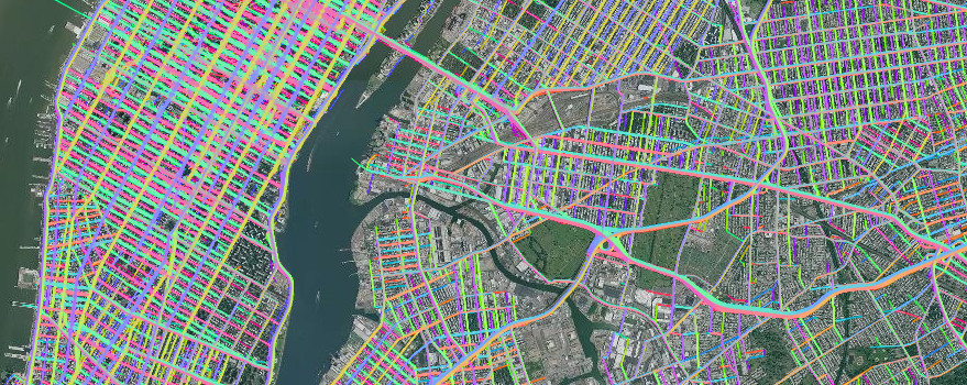
It all started with a bad edit. We in Juno rely on routing over OpenStreetMap roads, and notice every change that breaks the map matching. One day, we encountered a pretty big breakage caused by reversing some one-way roads. Turns out, all sources available to mappers, and even proprietary alternatives, like Google Street View, were obsolete enough to validate the edit. I told the story in my FOSDEM talk, but the main point is that it gave me an idea.

How fresh a source can be? We’ve got plenty of these, but they all are very old. GPS traces come very slowly, and people still trace lines from ten years ago. Satellite imagery is updated once every few years. Street View photos (that is, Mapillary) is always older than you’d like. If something, like a street direction, has been changed in past two months, you’ve got no way to know it and reflect it on the map, save for surveying it yourself. It’s okay for a small village, but not for New York.

Overview of Juno GPS traces over New York City

See full entry

Posted by ButanoCERT on 19 March 2019 in English.

Casey here,

The Butano CERT team has received some mapping equipment and a modicum of training from Capt. Ari Delay of CalFire.

Most of the time the CalFire guys are local and are familiar with the area. During the fire season crews rotate up and down the state… and so there is an effort underway to provide them with updated hyper local maps.

So we’re mapping with their kit; and iPad with GPS, a Dual GPS puck and a funky app called GISKit Pro. In using that gear we found that most of the basemaps are rather… oddly off WRT the roads in our community

They take the resulting KML with a custom set of features of interest to the fire fighters, and push them into their ArcGIS system for eventual publication into a number of tactical systems. ( the trucks get tablets with GeoPDF files, for example. There are some mobile and PC based apps for deployment and kitting.)

We use regular basemaps when tagging, and have decided to correct the OSM maps for our actual road layout. That makes it easier for our volunteer team to accuratly map features given the difficulty of GPS reading in our canyons.

Location: Butano Park, San Mateo County, California, 94060, United States
Posted by alexkemp on 18 March 2019 in English. Last updated on 24 March 2019.

On a day in May 2017 2 crack-heads† tried to kill me as I was mapping. They failed, I dialled 999, the police attended & in the end decided to ignore it (no CCTV, and the police sergeant claiming a lack of resources to investigate).

I guess that it is simple middle-class naivety on my part but I was profoundly affected by what I thought of as the refusal of the police to defend me.

The UK government has taken away the right to bear arms from all except the police, military & criminals (thank you Tony Blair). A former member of the Territorial Army that I know was recently asked to help clear his parent-in-law’s house following her death and discovered viable pistols + shotguns in the attic. He took the pistols back to his house and shortly afterwards was descended upon by the police. I counted 15 police at one stage standing around chatting outside his house + an unknown number inside. The whole palaver went on all night until the next morning, including police film-crews with portable floodlights conducting interviews outside the house with other police. The entire family is now in shock & clearly suffering from PTSD.

I had a touch of PTSD myself for the next 19 months, spending most of my time after the crack-head incident inside my house. I certainly could not face any surveying. In the end it was obvious that I had to drag myself up by the bootstraps and do something — in effect, re-boot myself.

Some little leaflets originally produced by Andy Allan were most useful but I was almost out of them. So, I spent time updating those promotional OSM leaflets and getting them printed.

Whilst huddled in my burrow Mapillary had spent it’s time vandalising my photos, all 6,200 of them. So, I spent time attempting to undo the damage using their blur editor. They ignored all my work.

See full entry

Location: Hockley, St Ann's, Nottingham, East Midlands, England, NG1 1LG, United Kingdom

In the SOTM Latam 2017 Perú, I realized that we are all very disconnected, that each community is doing its own things and that it’s really necessary to strengthen and rebuild our map together, show to each other what we are doing to see each other advances and have the strength to spread the voice in our environments and countries and can spread the OSM technology and tools around it and what can be achieved whit this tools that is very powerful and is still very unknown.

Creating this video to promote fundraising, I researched the communities in Latam and began an approach to motivate us to better organize ourselves. https://www.youtube.com/watch?v=KdETKQGGIPY&feature=youtu.be

Campaign Link https://vaki.co/vaki/osmcoytupale

Posted by renataveus on 18 March 2019 in English.

Last year I motivate my team to send a proposal to HOT Microgrant they don’t talk or write in English often and they have a discomfort getting out of the bubble but I encourage them, this work is all about Territorial arrangement plans. I think this is the most important field where to work right now in Colombia because many municipalities don’t even have a map to create this plan that is mandatory.

Sometimes I feel That I’m doing all this outside networking alone, but it worth it, because I feel more connected to the Latam community and I want to contribute to visualize not only the Colombian community work, also the Latam community work and contribute to the succession that is happening, the people that begin this process 10 years ago are tired, busy or disconnected they give us the most powerful basis now I want to help empower youngers and consolidate the work, the portfolio and connections .

At the beginning of the process with the HOT Microgrant, I as microgrant lead and head of communications, began to make connections, this was my first alert about my role in this process, questions about what happens with the contacts I make personally on behalf of the foundation, and how to leave a good detailed record that can be accessed by any member if needed, also as we began to receive technological equipment, such as GPS, cell phones, projectors and elements for the drone I began to think about how to make a detailed inventory and put this equipment at the service of the community with a loan protocol and a person in charge of each equipment with their contact details.

See full entry

Posted by renataveus on 18 March 2019 in English.

I present in Perú a game methodology and the achievement with indigenous, farmers and social leaders in rural areas and the importance of being using these tools in the post-conflict process that Colombia is living.

Social Media https://twitter.com/Cyberjuan/status/936674894481203200 https://twitter.com/piligab/status/936721573473644544 https://twitter.com/Cyberjuan/status/936724959434498048 https://twitter.com/osmpe/status/936720754325962752

Presentation https://slides.com/julianahdiaz/maperos-campesinos

I create a methodology called Pioneers Social and community Mappers that help us build the bridge with the most remote places in the country working with indigenous, farmers and social leaders in rural areas learning JOSM, fieldpapers, osmtracker, even QGIS for printed maps.

Spanish Post https://blog.openstreetmap.co/I13e00b253e58ecc587daa6134cfb7934

Summary of work with indigenous communities https://blog.openstreetmap.co/ie774b70ed48054130665080e2fc400ab

Summary of work with countryside people https://medium.com/@fosm/maperos-campesinos-cart%C3%B3grafos-sociales-y-comunitarios-78b0fd075ddd

Posted by dieterdreist on 18 March 2019 in English.

From time to time, people point to weird situations they encountered in their mapping. I’m going to collect some of these in this diary entry (and comments).

Traffic signs

In a discussion about traffic signs, the German forum mentions a node with a German traffic sign in France (on a track leading to Germany). As you can see, the reason is a track that starts on the French part but the only destination is back to Germany.

Posted by renataveus on 18 March 2019 in English.

2018: I led a project that was awarded a HOT Microgrant to develop Territorial Arrangements Plans in rural areas together with local governments and communities, overcoming many challenges and learning valuable lessons.

2017: Start the program Social and Community cartographers with OSM And open software tools in Partnership with an NGO. I design the gamificación methodology call Pioneers Program and during this year I work in workshops with three main groups between farmers(countryside) people, indigenous people, and social managers in some of the most representatives places of post-conflict in Colombia.

2016: I meet the OpenStreetMap Foundation in Colombia #FOSM and the Humanitarian Mapping Unit #UMH, I began to work with them, my expertise in graphic design and anthropology help me to address the areas in which I can contribute.

  • At the same time I meet the tool Tupale.co that allow create maps with information that looks like pretty close to what I’ve been looking build and I begun to participated updating the interface, the user experience, the layout, applying my acquired knowledge in HTML, CSS and javascript, learning PHP because this tool is built in this language.

2015: I work with Javascript community in Medellín co-organizing the main meetup and JsConf conference in Colombia for two years and leading a group designed for empower women and give them trust to embrace the challenge of participating proactively in traditionally male sectors and groups.

  • During this period I advocated value mapping of subjective and creative production communities. Mapping places for workshops, numbers of members in the community, new jobs thanks to the networking, hours of workshops, amount of volunteering working, presentation inventory, this kind of mapping give me tools to understand how to address assessment of communities, volunteering, and collective intelligence.

See full entry

Hello, world 🌎🌍🌏. I am writing this from Ōtautahi Christchurch, Aotearoa New Zealand. A masjid (mosque) in our neighbourhood was attacked by a white supremacist terrorist last Friday. Why did the attacker think that Aotearoa (New Zealand) is his land? We are grieving for our muslim brothers and sisters, and the event should make us rethink our worldviews, geography, and mapping. But who cares? Please read the following carefully.

Cartography, which includes geographic information, was and is part of colonisation, christianisation, imperialism, exploitation, dispossession, and domination. On the other hand, our present life relies on modern cartographic practice and mapping technologies, both of which inherit and reproduce the mistakes of the past.

I’ll give a petty indicator. Millions of people live in Oceania, but there is no emoji of the Pacific. 🌎🌍🌏 ?

How can we make sure that cartography, including the present trend of crowdsourcing geographic information, is careful and caring? What should a #caretography mean?

The only way for certain to identify villages in Turkmenistan seems to be to drive to them, find the town hall (‘‘geňeş’’), and record the name either by photographing it or, if lighting and the angle don’t permit, punching it into the smartphone or GPS. Ann’s and my curiosity got the better of us so over the St. Patrick’s Day weekend we have identified the villages of Ahal obasy, Tagan Baýramdurdyýew adyndaky geňeşligi / Gökdepe obasy (yes, that’s the full name of the village), and Täze Eýýam, which has had its name changed officially.

I wish all mappers out there the luck of the Irish!

Location: Ahal, Gökdepe District, Ahal Region, Turkmenistan
Posted by tadcan on 17 March 2019 in English.

With Brexit on the horizon and the possibility of customs post returning on roads that have had unimpeded access for the last thirty years or so, I had the idea of recording its current state for posterity. Around thirty thousand people cross the approximately 270 official places where roads traverse the border, from both sides, everyday. After raising this with other mappers they pointed out that by documenting its current state snaking back and forth across the border it would also provide a useful baseline to compare any changes to. Today the difference between either side is largely invisible, noticeable from small changes like the type of kerb stone, names of company’s on utility poles, the yellow or white road markings. So with a motorbike to make the journey, the next question was how to pull off this idea, esp, since the deadline of the 29th of March is near and the idea came late in the day.

On the OSM Ireland trip up to Belfast I talked about the project and got enthusiastic feedback. Coincidentally Mapillary were sending a gopro camera to fellow OSM mapper Dabigc, which suddenly made planning much easier. After it arrived we went for an practice run in his car to see how it worked. We looked at different options to mounting the camera on my bike helmet, unfortunately it has a piece of plastic that means it can’t be in an optimal position. The other option was a chest mount, but Dabigc pointed out pictures taken as I move my head around doing safety checks would add more information about the area.

See full entry

Posted by Alan on 17 March 2019 in English.

Late last year (around the Thanksgiving holiday in the United States) I wrote a blog post saying “It’s about time OpenStreetMap showed native lands on the map”. After that we had a few weeks of discussion and voting around the proposed tagging on the wiki (which is now approved as boundary=aboriginal_lands or synonymously boundary=protected_area + protect_class=24), and then a couple of months of refining the style proposal in the default OpenStreetMap stylesheet.

Now at long last, these features are starting to show up on the map. Here are a few examples:

See full entry

Posted by alexkemp on 14 March 2019 in English. Last updated on 23 June 2022.

North towards Chase Farm

Above is one of the final of the set of photos taken May 8, 2017, within the edge of a stand of wild trees looking north-west towards the ruins of Chase Farm. It is close to a ridge of high ground which runs from Nottingham (to the South-West) towards the North-East, which is on the other side of the Farm, and which today is called Mapperley Plains. Only 150 years ago it was full of trees and was called “Sherwood Forest” (yes, that Sherwood Forest), was originally owned by the King and renowned for The Chase.

I’ve finally added all the stuff I surveyed back in 2017 to the map, and will very soon be free to begin mapping again after a gap of 2 years. The bypass whose development you can just see on the LHS is one of the things that needs mapping.

Hope you like the photo.

Update 23 June 2022

See full entry

Location: Woodthorpe, Arnold, Gedling, Nottinghamshire, East Midlands, England, NG5 4JX, United Kingdom
Posted by baileykrause on 13 March 2019 in English.

I am trying to import aerial imagery into a massing model that I downloaded from OpenStreetMap into my Lumion 9.0 model. I have exported aerials from Google Earth Pro, imported that into Sketchup then placed this into my Lumion model but this will not scale appropriately. Is there a layer or a way to upload/import aerial imagery that will line up with my OpenStreetMap model? Thanks!

Posted by alexkemp on 13 March 2019 in English. Last updated on 23 June 2022.

Lime Tree Gardens Soakaway Lime Tree Gardens Soakaway (map)

This is the second time that I’ve come across a Flood Lagoon (the far-more-impressive first time was back on 20 June 2016 with the Carlton Foxhill Road Central Flood Prevention Lagoon. Thanks to lots of help provided on that First Contact, and after a phone call with Nav today (“my name is ‘Nav‘, like ‘SatNav’”) I’ve also got the inside skinny from Severn Trent on this one. And it is complicated…

There is a rectangle of grass (map) that encloses the whole thing:–

  • landuse = grass

3 sides have a metre-high fence (map):–

  • use menu: Highways|Barriers|Fence

The man-made structure that you can see in the centre of that photo above is two outlet pipes for a culvert that conducts surface water from the nearby estate’s roads into the soakaway:–

See full entry

Location: 52,995, -1,093
Posted by DoSchu on 13 March 2019 in English.

So much has changed in OpenStreetMap. Wow!

In my process of learning more, I start a map that locates artworks or cultural monuments you may enjoy while driving through the roundabouts of this beautiful island Mallorca.

Why thinking of artwork in roundabouts?

As we pass by, we miss quite often the chance to learn more about the piece decorating the roundabout (and preventing you from crossing this area the shortest way).

My interest was triggered when we passed the roundabout near Santa Margalida. A huge red devil, made from metal, chained in the middle, seemed to be somewhat disappointed… I needed find out more about this!

Dimonis Santa Margalida Roundabout ( my blog post about this piece of art in German )

Follow me to learn more.

Saludos de Santanyí, DoSchu

Location: Santanyí, Migjorn, Balearic Islands, Spain