Diary Entries in English

Recent diary entries

Posted by Minh Nguyen on 2 January 2019 in English. Last updated on 8 March 2026.

Oldenburg is a small town in southeastern Indiana, not far from where I grew up, where German is in some respects the official language. The town is proud of its German heritage. If you rely on a proprietary map for directions from Batesville to Metamora, you’ll probably miss a right turn at Oldenburg, which posts street names in German and only begrudgingly in English.

See full entry

Location: Oldenburg Historic District, Oldenburg, Franklin County, Indiana, United States

Setting Goals for DeBigC’s mapping

In the year ahead I want my mapping to be more strategic and pointed. I have set the following goals, to assist it in achieving this. These goals will be hard to achieve in total, but if the majority of them are, I will be very happy since they will mean I am moving towards my goals. I am a board member of OSM Ireland CLG LTD, so just for clarity sake these goals are nothing to do with any position taken by the board or on behalf of the community.

My Hot-Spot

Firstly, I want my heat map to shift to Ireland. I have been a large #MapLesotho contributor, but for my own reasons I want to map Ireland much more. At the moment the largest concentration of my nodes is Lesotho as shown on this heatmap

My Ireland Rank

Next, I want to maintain a top 10 place in the Ireland 2 monthly contributor list. I’m all for other power mappers flexing their muscles, so this is a relative target to whatever they contribute, I will stay up with them.

Map on the move

Ireland doesn’t have a “millionaire” Mapillary user, and there are more than 50 of these worldwide. My target has three aspects,starting with me reaching 1 million images by the end of January 2019 (right now I’m on 913k). I want my Irish image haul to reach 1 million by June 1st.

Mapping Gaps

Regarding my own contributions Dublin is priority. For some reason large parts of North Dublin are not well mapped, with some exceptions like Castleknock and Clontarf, due to the stewardship of large locally focussed mappers. However, there are huge swathes of urban Dublin barely mapped at all aside from landuse and road networks. I’m aiming to map Coolock, Raheny, Drumcondra, Beaumont much more than they are done, to the point where all the buildings in these areas are complete.

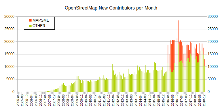
I’ve just updated the contributor statistics for the whole year 2018.

As I pointed out here 2017 update blog post some the graphs look a bit odd due to the one-time effect of an initial large number maps.me users contributing as the editing feature was introduced.

This effect continued to decrease during 2018, but for completeness sake here are the updated graphs from the blog post for 2017 that continue to show continuing growth even without maps.me.

See full entry

Posted by exiy on 31 December 2018 in English.

I recently took to completing some of the tasks in the one of the challenges on MapRoulette named Phone or fax number is not in international format (Australia).

The purpose of this entry is to detail my findings in undertaking this challenge relating to the formatting of phone numbers in Australia for OpenStreetMap.

ITU-T E.164 phone number formatting

The formatting as defined in the wiki follows this pattern:

+<country code> <area code> <local number>

This is the ITU-T E.123 and the DIN 5008 pattern and is the assumed preferred pattern given the RFC 3966/NANP pattern is parenthesised and provided secondary on the wiki entry, in addition, the NANP pattern refers to North American use.

Country/area codes for Australia

Using information from the Australian Government website and the Wikipedia page titled Telephone numbers in Australia the following was identified as relating to the above pattern:

The country code for Australia is 61 and applies to both phone numbers and mobile numbers.

The area codes are for sets of states in Australia. These are; New South Wales and Australian Capital Territory as 02, Victoria and Tasmania as 03, Queensland as 07, Western Australia, South Australia and Northern Territory as 08 and applies for phone numbers but not mobile numbers.

The area code for mobile numbers is 04 regardless of state.

The leading 0 in each area code is only retained when calling nationally, whereas when calling internationally (as is the practice for the pattern of phone numbers in OpenStreetMap) the leading 0 is left out.

Examples of Australian formatting

For phone numbers:

+61 x xxxx xxxx

For mobile phones:

+61 4xx xxx xxx

See full entry

Our underpaid team of data wranglers have been working diligently over the last six months to develop and bring forward our proposal for importing addresses statewide into Massachusetts. This has been no easy process, and has many specific concerns which we’ve been working hard to address over the last six months of development for this plan. We have come up with a multiple phase-based import approach which we believe mitigates data issues while providing high quality data to be imported, sought feedback from our local community, and have now submitted our request for comments to the national imports@ list for further discussion before starting the import process.

As a background, we discovered MassGIS data on address parcels available through the 911 data within the state. The raw data consists of points which are located on top of the building centroids, as far as the state is concerned where the buildings are. For multiple building properties, the address point is located in the center of that property. This is workable, but means the data has to be filtered between the two import phases to fix the correlation between the two types of nodes.

This marks a significant milestone within our local community’s mapping development. Importing addresses to every building in Massachusetts is no small task, but the effect on data quality and usability of OpenStreetMap will be significant. The wiki link for our import proposal can be found here: osm.wiki/Import/Catalogue/MassGIS_Addresses

You are invited to provide feedback on our process on imports@. If you’d like to contribute, we need data wranglers and coders. Feel free to reach out on talk-us-massachusetts or #massachusetts on the OSM US Slack.

Posted by alexkemp on 30 December 2018 in English. Last updated on 5 February 2019.

OSM flyers

  1. Fonts missing from OSM Promotional Leaflets
  2. Github HowTo: Clone Repository then make a Pull Request
  3. Printing OSM Promotional Leaflets
  4. Update to OSM Promotional Leaflets due to Padding errors
  5. Adding a Preview JPG + crop-marks for printing

tl;dr:
You will need to install a combo of ubuntu font, a suitable Sans-Serif font (OpenSans family font is available via GitHub) + Inkscape in addition to mirroring locally the current GitHub OSM files. Then use Inkscape to import one of the SVG files, Save-As a PDF from it, and print from that. Rinse/repeat with the other SVG file:–

Updated PDFs + SVGs (identified by ‘r15371’) are currently available at https://github.com/alexkemp9/openstreetmap-promotional-leaflets. In addition I’ve made a pull-request (a request within Github for the original author to consider pulling-in my changes), so they may soon be available from the original source (next line).

See full entry

Location: Hockley, St Ann's, Nottingham, East Midlands, England, NG1 1LG, United Kingdom
Posted by combloop on 29 December 2018 in English.

An early happy new year to everyone!

I’m not even 6 months into mapping and I’ve already finished 7 municipalities of Bergen County. This year was great, and I plan to continue with contributing next year.

I’ve just finished Maywood after a time period of slightly over 2 weeks. Next should come Rochelle Park, and after that I might start Woodcliff Lake.

I noticed that there is a lot of industrial land in Maywood’s western portions, and that the are south of Central Avenue is very dense. Meanwhile, the northern area seems to be less dense and the eastern area is almost entirely residential. I’d say the west and south areas are like Hackensack, while the others are a bit more like the less populated places in the area.

Additionally, mapping Memorial Park made me realize how large the park actually is, and the park seems to have a lot. It shares the Memorial name with the nearby Memorial Elementary School, one of two schools in Maywood along with the one on Maywood Avenue.

Also, I’ve made it to over 750 changesets this year, and lots of map changes! I’ll almost certainly reach 800 while mapping Rochelle Park.

Click below to see Maywood!

Location: 40.903, -74.062
Posted by Emma G on 29 December 2018 in English.

Hello everybody,

I’m sorry because I’m not sure here’s the right place to ask this question but I’m trying to modelize a road network on my computer for a project and I don’t know how to use OpenStreetMap data to do that (or even if it’s possible). I would like to create a graph with cities as nodes and roads as paths, based on the real road network, but it would be too long to implement that myself (I need a complex graph with a least 10 000 paths) so I would like to use data from somewhere. If someone could help me, I would be very thanksful !

(I’m a French student so I guess my English isn’t perfect…)

I’ve stumbled across Mapillary and wondered how to cover an area completely. Sadly, Mapillary help pages themselves weren’t very useful[1]: > Plan your route in advance. If you aim to cover a big area, divide it into smaller sections and think through how much you can do at a time.

What it doesn’t say however, is how to actually plan your route. My thought was that especially within areas with mapped streets you could get a route as GPX-file to follow.

Research

In my efforts I first had to learn what problem I am actually facing. It is not “Traveling Salesman Problem”[2] but actually “Route Inspection Problem”[3]. Both problems are computationally hard, i.e. NP-hard. This means you can’t solve them for larger data within any reasonable time. In this case even a “small” road network (some hundred streets) was too much for my desktop computer. However for special cases good algorithms do exist for this problem. One that I’ve found is for non-directed graphs written in Python as a plugin for QGIS, but runnable on its own[4].

Planning a route

This actually works, however you have to convert OSM-streets into usable CSV-files first. I’ve done this using a short Python script and Overpass-turbo. All steps can be seen here: https://gist.github.com/nmxcgeo/739e87333f61234aff5a32bbf735cef7

Shortcomings

There are several shortcomings of my procedure so far.

  • It includes turning, where it is unlikely to be physically possible.
  • It doesn’t value oneways
  • and includes some links between streets that aren’t necessary to visit separately in practice.
  • It doesn’t check for connectivity of all roads to the same network and doesn’t necessarily pick the largest network.

Especially because of oneways I currently wouldn’t use it in practice. You might consider it for developing countries or desaster mapping if oneway doesn’t play a role within your region.

See full entry

Posted by Magick93 on 25 December 2018 in English.

It’s that time of the year & I would like to take a moment to wish everybody in the OpenStreetMap community Merry Christmas. I hope all find it within yourselves to give the best of you, not one day or two but at every moment. And also so that we can keep helping -through mapping- to make a better world.

Best wishes, Magick93.

Posted by apm-wa on 24 December 2018 in English.

The authoritative list of provinces, districts, and municipalities of Turkmenistan coupled with the legal definitions of types of municipalities have allowed me to categorize the “cities” of Turkmenistan following visits to many of them or collection of on-the-ground data about them either directly or through third parties. I am almost done with the list of “cities” (şäherler).

I have not yet located one city on the list: the city of Dostluk in Lebap velayat. There is a village called Dostluk that is part of another village council (Serdar geňeşligi), but it is unlikely to be a “city” unless the authoritative list of municipalities contains an error (always possible and not to be completely disregarded). Where is the mysterious city of Dostluk in Lebap velayat? It has to be there, somewhere!

Posted by Nayeem_Arv on 24 December 2018 in English.

I started my OpenStreetMap journey from 2015 in kamrangirchor . My and my first work is to build the kamrangirchor map. When Me and my group involved in osm we are in class 11th.Firstly we don’t understand what we are doing but we are having fun to do this work and we are also happy we get the opportunity to work with different type, different culture of people. I and my team with jorek Vyncke for the field training and small get together to grooming with the other volunteers. After that, we started the work on kamrangirchor map. We learn here how to do a field map.

It’s our last day of kamrangirchor field mapping.

Next Remote Mapping through satellite. First I get a little bit to confuse how to do this work after getting the full training. I’m a little bit curious about the work.

After the training i had done we are on work on the map.And for my study, I’ll take a break from mapping projects.

I have work in so many projects. 1.Water Managment project 2.Satkhira Project 3.Japan Flood. 4.Srilanka Project 5.Rohingya projects 6.Cyclone In Gaja project ETC. My osm Edit History

osm.org/user/Nayeem_Arv/history#map=11/23.3723/91.1804

OSM-related accounts:
OSM help
OSM forum
[OSM Wiki](osm.wiki/User:Nayeem_Arv HOTOSM

Location: Islam Nagar, Kamrangirchor, Dhaka, Dhaka Metropolitan, Dhaka District, Dhaka Division, 1211, Bangladesh
Posted by seism on 23 December 2018 in English.

Strewn around the village of Ringgenberg, the Ringgenberg-Goldswil Planet Walk (or “Planetenweg Brienzersee”, as it was originally titled by habi 3 years ago) is a not very prominent, but enjoyable local attraction.

There are about 20 such planet walks in Switzerland. My children just had the topic of space exploration at school, so they were very motivated to go from stop to stop, looking at the scale models of the planets and reading the information boards. And I realised that only the first three of the planets were to be found in OSM.

This is my first time editing OSM with this user account (I seem to have lost access to older ones), and on top of that I was using Vespucci as an editor for the first time. But the process was pretty intuitive, and I managed to link my new nodes to extend the existing Relation, as well as make some changes to the underlying data.

The question of who maintains this walk is a bit open. Only the English Wikipedia entry for the village currently mentions the walk, and online I could only find basic references to it from the local (archived) and national tourist boards. The only other source of information, besides mentions from local tour guides, is the Swiss Astronomical Society. If anyone finds more literature, I would be keen to know when this was built, and how it is maintained.

I’ve only gotten as far as Saturn today, which leaves 4 points, including Pluto, out there to discover and map. Maybe tomorrow.. And if you have comments on my Changesets or any other ideas for how to contribute to OSM in the region, please let me know!

In the meantime ..

Merry Christmas !

osm.org/changeset/65718390 osm.org/changeset/65718443 osm.org/changeset/65718564 osm.org/changeset/65718644 osm.org/changeset/65718683 osm.org/changeset/65719021

Location: Spycherli, Ringgenberg (BE), Interlaken-Oberhasli administrative district, Oberland administrative region, Bern, 3852, Switzerland

I just learned about cesium.com/ion. It is a website that allows one to create ‘Assets,’ or sets of 3d-tiles, and host them for a cesiumjs.org instance such as webglearth.com ( 3d Leaflet ) . One can choose to upload (3d aerial photogrammetry)[https://cesium.com/docs/tutorials/uploading/] that gets carved into vector 3d tiles that are hosted as an Asset through Cesium. Each tile is one WebGL draw call.

Somebody might want to grow these 3d-tiles from the ground up artificially if he can’t fly from the skies. An Asset producer may regularly update from OSM in order to parse the tags for elevation, vegetation, buildings, etc in order to grow the tiles based on tags.

Some fun with Assets: let’s say you had 3 ‘visibility layers’ to choose from, those being buildings, vegetation, and terrain. To maximize efficiency, you should host X Assets if you have Y visibility options: X := Σ for n=1..Y, Y choose n. Basically, one Asset for every possible selection.

Location: Ventura County, California, United States
Posted by ika-chan! on 21 December 2018 in English.

I wished that setting up a standalone OpenStreetMap server, with the likes of Rails, Mapnik and Nominatim all in one computer, was as easy as setting up MediaWiki. I think that the ease of setting up MediaWiki is why MediaWiki-based wikis are so popular.

If setting up a standalone OpenStreetMap server was as easy as setting up MediaWiki, many people would be mapping their own worlds on their own servers, saving OpenStreetMap the headache of dealing with fictional edits.

Long story short, I still wish to set up a standalone OpenStreetMap server for my NationStates nation under Ubuntu 18.04 LTS, but I think I will need help with the development of a simple method to set-up such a server — not only due to my poor health, but also to make things a lot easier for other fictional mappers that can’t fit their worlds into OpenGeoFiction.

I am sorry about the request for help with the server setup instructions, but my health matters more. At least I got my feelings about the complexity of setting up such a server out of the way before it overwhelms me.