Diary Entries in English

Recent diary entries

All Mapbox users, using an access token from their own account, are allowed to create derivatives from Mapbox Satellite for contribution to OpenStreetMap via manual or automated processes for free.

Guidelines

  • All extractions must be non-commerical or OSM-improving. Examples:
    • an academic researcher could use the imagery for a non-OSM use
    • a company or individual could use the imagery for adding to OSM
  • All use of this service is subject to the Mapbox TOS, with a link to our TOS.
  • If you have another purpose for your extractions, get in touch with us via sales@mapbox.com.
  • You’ll need to have a Mapbox account and to use a token from your Mapbox account for all your ML requests. This will help us interpret any traffic issues and communicate with you if they come up.
  • Safe rate limit for downloading satellite tiles is 100 request per second. If you want to exceed that rate, please reach out to community@mapbox.com .

Whether powered by machine learning or not, we’d love to hear about your imagery use cases. And as always, if you have any questions, please reach out to us!

I have geolocated and mapped all Russian Orthodox Churches cited on the website www.pravoslavie.tm/prikhody. Some were already mapped, but not all. This has involved in a few cases driving to the cities in question, asking locals where the church is located, and driving to it to mark it. In other cases it has involved querying locals as to the location and having them point it out in Digital Globe imagery for me. That last one we found was the Church of the Apostle Thomas in Tejen, which someone had mistagged as a mosque. Many thanks to all who helped!

This week I traveled to Mary and collected a few thousand Mapillary images along the M37, which are in the process of being uploaded. I identified some more POIs plus have updated some obsolete street names. There are three major hotels in Mary (Mary, Margush, and Yrsgal), and all three are now well marked in OSM for the convenience of travelers. There is also a new supermarket, Belent, and it is marked now as well. That’s not to mention the out-of-the-way Gas Station 19 on a rural road that we stumbled across!

Location: Tejen, Tejen District, Ahal Region, Turkmenistan

A Mapping effort in Thrissur District, the cultural capital of Kerala for Marking the Buildings, Roads, Trees, Ponds and other historic places in the city. The City is built around a 65-acre (26 ha) hillock called the Thekkinkadu Maidan which seats the Vadakkumnathan temple. Thekkinkadu means Teak Forest. Thekkinkadu Maidan was a dense forest in olden days. Maharaja of Cochin, Rama Varma Sakthan Thampuran cleared the place and maid the Thrissur City. It hosts the spectacular cultural festival Thrissur Pooram.

In City some greenery remains in some part and we need to survey and map the places and diversity. Because of these trees we have good birds actives and with Kole Birders community there is an efforts happening to document the avian and tree diversity of the heart of city. Hope Free Software Users Group Thrissur also join the efforts. combining all interested group we can map our city

Location: Mission Quarters, Chelakkottukara, Thrissur, Kerala, 680005, India
Posted by Zverik on 16 May 2018 in English.

A new minor release of MAPS.ME is coming, and just now I’ve got the new data for it — with numbers on size and features difference with the old data. First, sizes:

  • Indonesia_Central.mwm: 107 up to 127 MB
  • Tanzania.mwm: 212 up to 225 MB
  • US_Indiana_North.mwm: 19 up to 25 MB

Basically the same as the last time, except Portugal was replaced by Indiana state. And there was some prominent activity in all of Peru.

See full entry

Posted by mvexel on 16 May 2018 in English. Last updated on 21 May 2018.

Telenav created and hosts OpenStreetCam, as many of you know. OpenStreetCam now has well over 130 million images contributed in large part by OSM mappers (thanks!). We already integrate the images themselves with JOSM and iD.

About a year ago, we started an internal initiative to apply machine learning to detect important features such as signs that are captured in the images. While we haven’t rolled that out at scale yet, you can already see the results in some US metro areas such as Salt Lake City, Detroit and Dallas / Fort Worth, using the latest version of the OpenStreetCam JOSM plugin. The goal is to make mapping sign content much easier and quicker. You can, for example, filter speed detected speed limit signs to see only the ones where the way in OSM does not have this speed limit yet.

So far, the technology behind this has been internal to Telenav. This is changing today.

See full entry

Posted by alspace on 16 May 2018 in English. Last updated on 17 May 2018.

Relation: Tour Aotearoa (from gpx files) its time this was drawn completely, fine points like food shelter and drink, state of road / track - can all come later

Hauraki Rail Trail Relation=”Hauraki Rail Trail” network=ncn

4 sections, 3 are part of TA. Pukorokoro Miranda to Kopu Trail - plotted from gpx overlay, still need to re-ride and check the plot is accurate, add gates, parking, …

Al

Posted by Thomas_Hervey on 14 May 2018 in English.

Week 1

Today is the first programming day for GSoC 2018. If you haven’t read about the student projects, go take a look! For this week, I will be firming my understanding of the iD services implementations (paying particular attention to mapillary and openstreetcam). Notes will end up being a toggleable service much like these two. Thus far, I’ve already experimented with many parameterized curl calls to the Notes API, and have delved deep into D3 (since iD relies heavily on it). This week, I am also going to explore how JOSM handles notes (to see if it is different from openstreetmap.org).

If you’re curious about other improvements to notes, please share your ideas here and take a look at an ongoing discussion about categorizing notes.

See full entry

Today I am super excited to announce Idly-Gl! It is an opensource Mapbox GL plugin which renders OpenStreetMap data.

idly-gl

What is Idly-Gl?

Idly-Gl is a small plugin which reads data from Openstreetmap’s API and renders it on any Mapbox GL map. Click here for a demo.

What is IDLY 🍚?

Idly is an Indian rice cake 🍚. I picked this name as it can be the little brother of iD editor.

Why did you create it?

I work with a lot of Mapbox-gl maps and I am very impressed with their speed and portability. I have also worked with iD editor and it has impressed me with the way it handles OSM data. The only problem is that these two don’t talk to each other well. To bridge the gap, we would have a button to open it in iD. This works well when you have to make an edit, but if a user just wants to inspect/visualize OSM data the only option is to open the OSM website.

What does it do?

  • 😎 It renders live osm data on a mapbox-gl map, which makes it blazingly fast.

See full entry

Posted by SimonPoole on 14 May 2018 in English. Last updated on 1 June 2018.

Work has proceeded nicely on the next major release of Vespucci and while there are still some rough edges and not quite everything has been added that I intended to, it definitely makes sense to test this version. THe beta APK is available from googles play store and our github repository.

Layer control

The most obvious visual difference in version 11 is the layer control on the main map view.

Currently it is not possible to change the ordering or add more than one layer of a specific type, supported functionality:

See full entry

What am I writing about

I support on of our projects in a mapping exercise that looks at access to services important for persons with disabilties in Rwanda. For now we have a bulk of information on 256 services, notably looking at the aspects: *Adresses of the services (inc. GPS) *General description of teh service *Target group *Accessibility levels *Levels of inclusion

I would appreciate, if you could have a read through the article Geography and Inclusion

Location: Neukölln, Berlin, Germany
Posted by apm-wa on 12 May 2018 in English. Last updated on 13 May 2018.

Do a virtual drive via these Mapillary images I took last week of the pass cut by hand by Japanese prisoners of war after World War II. The pass was carved out of solid rock using hand tools.

There is a small memorial to Japanese POWs at the top of the hill.

So far about 5,000 of the over 30,000 images I collected on this trip have been uploaded. I copied them from my smartphone to my desktop computer and am using the desktop interface with Mapillary.com to upload them. Due to the slow internet speeds of the Turkmen internet, it will be a while before all images are uploaded.

Location: Türkmenbaşy, Balkan Region, Turkmenistan
Posted by bgirardot on 11 May 2018 in English.

Zverik’s diary post contained the word “Gatekeeprs” and I have also used that term, as well as “self appointed Sheriff’s of OSM” and “grumpy people” :)

OSM contributor Dzertanoj made the comment that “Gatekeeper” was a very negative term in Russian, that it even implied “dumb”. In American English it is a negative term, but mildly so. In fact, to most folks it even implies the longest contributing, most experienced folks in an open source project.

Gatekeeping is a critical role to a large open project like OSM.

The problem is, that over time, years of experience supporting and contributing to the project, the gatekeepers are in the best place to see what is needed to keep the project at a very high level of quality, which OSM is at, a very high level of quality, infrastructure, data, code base, ecosystem, etc, it is in large part due to the gatekeepers.

But I think what happens is that after several years, over 10+ years in some cases, of seeing all sorts of folks and ideas and efforts come to the “commons” that is an open source project, the gatekeepers get a little focused on keeping the gate closed. They have cleaned up after this, heard this, seen this, tried this, whatever it may be and they know all the parts that cause issues on the commons. So they rightly keep the gate closed or try to.

What is needed, what I have personally tried to do, and what HOT (disclosure: I am a HOT member and past board member) tries to do is be “Gateopeners”

We know the rules as the community and gatekeepers in particular have created, they are things like the import guidelines and draft of the directed edition policy are two great examples.

See full entry

Location: Old Fourth Ward, Ann Arbor, Washtenaw County, Michigan, 48106, United States
Posted by kocio on 11 May 2018 in English.

Dear all,

Today, v4.11.0 of the OpenStreetMap Carto stylesheet (the default stylesheet on the OSM website) has been released. Once changes are deployed on the openstreetmap.org it will take couple of days before all tiles show the new rendering.

Changes include

  • Fixed office/amenity conflict
  • Brightened built-up areas on z12
  • Refurbished natural=spring icon
  • Added rendering for amenity=police and amenity=fire_station areas
  • Added rendering of amenity=nursing_home
  • Added rendering of amenity=childcare
  • Added rendering of amenity=driving_school
  • Added area rendering for amenity=bus_station
  • Added area rendering of amenity=taxi
  • Made highway=traffic_signals icon less obtrusive
  • Moved barriers to higher zoom level
  • Hiding railway=platform with location=underground, tunnels and covered=yes
  • Small documentation and code fixes

Thanks to all the contributors for this release.

For a full list of commits, see https://github.com/gravitystorm/openstreetmap-carto/compare/v4.10.0…v4.11.0

As always, we welcome any bug reports at https://github.com/gravitystorm/openstreetmap-carto/issues

Posted by alexkemp on 11 May 2018 in English. Last updated on 22 May 2018.

You may have missed the reports in April about Willand, a pretty little village in Devon that is 2cm (0.7 inches) closer to god each year (from the heliocentric view, of course), yet no-one knows why:

Willand village in Devon

The connection to OSM is a little tortuous, but real.

The University of Nottingham has a Geography department, and it has spun off a commercial company called Geomatic Ventures Limited (GML). GML has created a United Kingdom Relative Deformation Map using results from the Sentinel-1 satellite. Here is the blurb from the mangomap site:

United Kingdom Relative Deformation Map

A relative deformation map of the United Kingdom, generated from ~ 2000 Sentinel-1 images acquired between October 2015 - October 2017. The data was processed using the Intermittent Small Baseline Subset (ISBAS) InSAR method. Each pixel represents the average vertical height change over the period of observations in millimetres per year.

See full entry

Location: Willand, Mid Devon, Devon, Devon and Torbay, England, United Kingdom

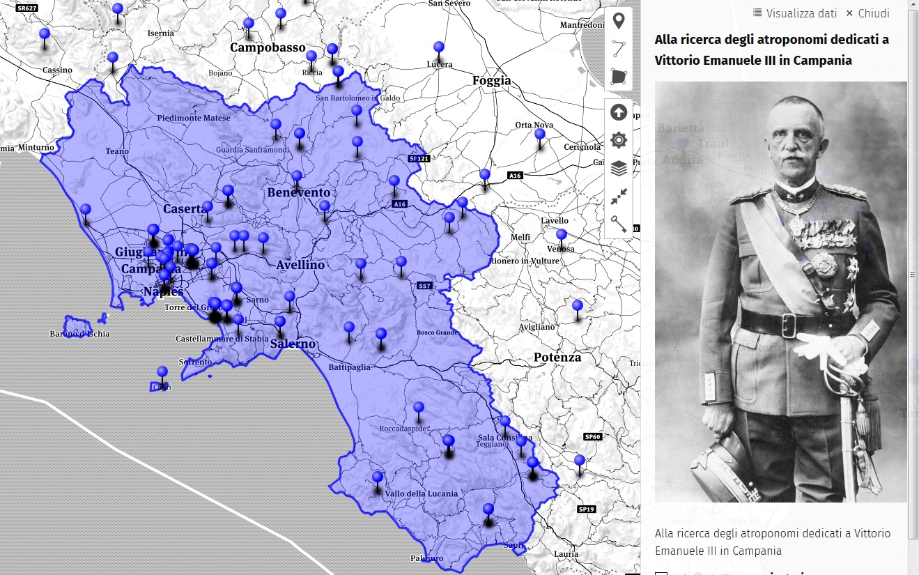
As part of the #cittasenzamemoria project, the verification of toponyms dedicated to Vittorio Emanuele III in Campania was updated.

Campania

The data comes from the map of OpenStreetMap aimed at creating a free content cartography of the world. The map information is freely accessible under license ODbL and updated every day. To facilitate the consultation, the toponyms are also available on the dedicated online map. A total of 50 names were identified below:

id name City

See full entry

Posted by apm-wa on 11 May 2018 in English.

I am working on the Turkmenistan page in the OSM Wiki, seeking to add information I’ve acquired during my tour of duty here in Ashgabat. If you have suggestions for information that should go on this page for purposes of preserving institutional memory, please sing out! If I don’t possess the information I’ll try to find it during the time left on my tour of duty.

Location: Tejen District, Ahal Region, Turkmenistan
Posted by Joel Hansen on 11 May 2018 in English. Last updated on 8 November 2018.

This entry is for my reference and for anyone who is interested in cleaning their motorways.

I have decided to do some clean ups and fixes along a motorway (mostly linking roads) here in Australia. I think this is important for GPS usage, or otherwise clarity sake whilst viewing. I want to list the things I did to cleanup and otherwise improve.

Fixing Roads

This one should come as no surprise. It is important to use a good imagery source and offset by GPX. Keep in mind that people driving will be in different lanes, so align the road to be in the centre of this.

Different lanes should not be mapped as individual ways.

Use of destination tags on linking roads and junctions (e.g. offramps and onramps)

This one is important for GPS navigation. Here are the tags that I’m going with:

destination= This tag is for whatever the sign says, I reserve this one mostly for a Suburb or City name. Use a semicolon to separate multiple names: City 1;City 2. Mapillary and OpenStreetCam help here.

destination:street= The name of the road that is at the end of the linking road.

destination:ref= The reference number of the road that is at the end of the linking road.

destination:network= I think this one is unofficial, but I use this if the destination has a network.

Adding/Improving junctions

Someone has already done a good job at adding most. However where I am, motorway junction nodes are only present when the exit has a ref number (e.g. Exit 32). This isn’t good for exits which don’t have numbers. So to areas which didn’t have any. I’ve added them and used the destination tag on them instead.

I have also added destinations tags to existing ones where needed. These were placed as per the wiki’s instruction.

Making transition roads at junction

Although the placement=transition tag isn’t official, I like to use it on the slight bit of road that connects the motorway to the motorway_link road.

See full entry

Location: Fig Tree Pocket, City of Brisbane, Queensland, 4069, Australia