Diary Entries in English

Recent diary entries

During another trip to Turkmenbashy to attend the 9th Annual Gas Conference, I took a few hours to collect more GPS traces and Mapillary ground imagery in and around Turkmenbashy, including the seaport dedicated on May 2. The updates to the seaport are uploaded now–additional roads, placement of important terminals (including the passenger and ro-ro terminals), and tweaks to the approach roads.

We also geolocated the Kazakhstan and Russian consulates in Turkmenbashy, which means we now have all diplomatic and consular missions in Turkmenistan on the map, complete with addresses and telephone numbers. We located and collected contact information for the three downtown hotels (Charlak, Hazar, and Turkmenbashy), i.e., those not located in the Awaza tourist zone.

I also started a wiki page on the city of Turkmenbashy, as a companion to the pages on Turkmenistan, and cities of Ashgabat and Mary. All of these are far from finished, so please be patient as I collate information and upload it. If you have suggestions or criticism or thoughts on these pages, please sing out!

Location: Kenar, Türkmenbaşy, Balkan Region, Turkmenistan
Posted by SunCobalt on 26 May 2018 in English. Last updated on 30 May 2018.

As recently suggested in my previous post “Will the DWG block us all one day?” I took a deeper look into it. I have scraped all 1934 user blocks available last friday together with some user information.

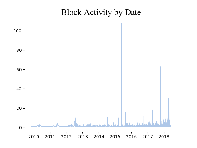
As already indicated, the DWG is blocking more and more user (< no judgement) …. probably along with the increasing interest in OSM and the influx of trolls and paid editors.

In May 2015 an user registered more than 100 accounts with names of public transport stations in Berlin and was blocked. In October 2017 around 60 accounts related with an education session called COMS2200A were blocked. During April 2018 29 accounts from GlobalLogic India were causing troubles and got blocked after a complaint in the osm.org user blogs.

dailyActivita

If the trend continues, 2018 will be another record year of user blocks.

See full entry

It’s been almost a week since I got back from Davao, but I’ve yet to write anything down about the OpenStreetMap activities we had there. So, here’s a quick round-up:

“Open Source Mapping” with Tambayan Center

“Is the Bermuda Triangle for real?”

This is the most interesting question I got from this workshop!

This mapping project was in the pipeline since the middle of 2017 when Tambayan Center sent me a query over email, and it just happened that I was also in Davao at that time. I dropped-by (and, of course, mapped ) their office to get their feet wet about OSM, and maps in general, and listen to details of what they’re trying to do. Tambayan Center is a long-standing NGO operating in Davao and working mostly with concerns and rights of young people, and their communities.

image Breaking ~~bread~~ ice cream and chips with the Tambayan Center team during my last visit

See full entry

Location: Barangay 4-A, Poblacion District, Davao City, Davao Region, 8000, Philippines
Posted by daniel-j-h on 25 May 2018 in English.

In the following I describe how we implemented reasonable alternative routes in the Open Source Routing Machine’s Multi-Level Dijkstra mode.

Final result: generating reasonable alternative routes incredibly efficiently

Our main goals when designing and implementing reasonable alternative routes were two-fold:

  • provide reasonable alternative routes for end-users and use-cases such as generating many alternative routes letting users or developers decide between them (e.g. runner’s app, start and end is the same but provide different route each day), and
  • guarantee for fast query times in the tens to lower hundreds of milliseconds to fit the Open Source Routing Machine’s trade-off of doing heavy pre-processing and then get incredibly fast exact responses

But what exactly do we mean by “reasonable” alternative routes? When we find a fastest route and compute alternatives these are the criteria we try to optimize for:

See full entry

Posted by rene78 on 24 May 2018 in English. Last updated on 12 June 2018.

I would like to recount an interesting encounter I had during a bike trip in Myanmar. In December 2016 I cycled from Yangon/Myanmar to Kuala Lumpur/Malaysia. Beforehand I was armchair mapping some tracks east of Bago, Myanmar in order to avoid the stinky and noisy main road and slightly short-cut the trip. Later I used OsmAnd+ to navigate those tracks.

It was precisely on these roads in the middle of nowhere - Google Maps is literally blank there - where I met a female solo bike traveller. She used Maps.me to navigate and was using ‘my’ roads to go into the opposite direction.

Quite entertaining to see the real world impact of all our mapping efforts.

Here is a picture of one of those newly mapped roads at a slightly different location.

Location: 17.370, 96.726
Posted by ShadowFoxNixill on 24 May 2018 in English.

Followers of my profile (all 2 of you) may have just noticed an edit go live about 600 miles away from where I normally edit. This isn’t armchair mapping; I went over to Manchester to see my long-distance boyfriend but knew in advance that he didn’t have the week off so I brought the maps along to occupy myself during his shifts.

I managed to ride all fifteen of MTA’s routes in three days; fourteen of these being while he was working and one while he was asleep.

MTA is different from SMART in a few ways:

  1. Posted bus stops are kinda just… suggestions. Except for three of the routes, passengers can just wave the bus down anywhere along the fixed route to get on, and request a stop anywhere from the driver.
  2. Trips after 6:30 don’t even make you get off on the official route. The last three 5s and 11s run what’s called “deviated fixed route”, which means the bus will deviate from the fixed route to drop you off - up to 3/4 of a mile is what the driver I actually did it with said.
  3. All the drivers go everywhere. The bus you catch from the Mall of NH may just continue on to SNHU, if you catch it at the right time.
  4. The buses can hold for each other. If you’re on a late bus trying to catch another, just ask the driver, and they’ll radio in for the next bus to wait, if they’re not that next bus themselves.
  5. From Downtown to the outer end, and back, is considered a single trip.
  6. Colby Court Senior Center is by request only. The same applies to Elliot at River’s Edge for the 3 and inbound 12 - though it has regularly-scheduled service on the outbound 12.

Because of point 1, there are actually long stretches without any posted stops. Route 4 doesn’t have any. The map I’ve uploaded consists of:

  • Any stop with a physical MTA or Green DASH sign
  • Any location on the route with a shelter
  • Any timepoint in the schedule

See full entry

Alt-Text

I have noticed a trend that user blocks are more and more “requested” for things that were accepted in past (i.e. not responding messages/empty changeset comments etc).

Although OSM claims to have 4,607,162 users [1] only 16,431 were editing during the past week [1]. On the other hand, I have counted roughly 1,800 user blocks [2]. I know that one user can receive multiple blocks. However, the proportion seems odd. Looking at the chart, I have two questions in mind. Altough the DWG creates regular reports, there is nothing about this in it.

See full entry

Telenav / Scout image

This is a YouTube video uploaded on 7 Aug 2014 by ScoutbyTeleNav, and celebrates 10 years of OSM existence at that time, giving a visual demonstration of the month-by-month build of OSM by all it’s contributors. This video makes me proud to have added a little to OSM, even though for me that did not start until after this video was made.

And yes, I know that this is a bit old but watch it anyway, and I think that you will agree that it is an excellent video, worth watching. The music (also excellent) is Open Electro by Vincent Girès from the album Silence.

10 years of OSM: youtu.be/7sC83j6vzjo

PS
OSM Founder Steve Coast is the Head of OSM at Telenav

At the end of 2017 I was the biggest Mapillary contributor in Ireland, without really trying too hard and just using a front facing Samsung camera in my car and short diversions on the commute to and from work.

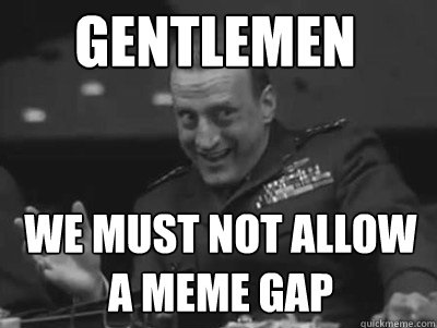
At some point around March 2018 my good buddy and OSM Ireland contributor Dave jumped ahead by about ten thousand images. I made a solemn (ahem… competitive, but sporting) promise/threat to get working on closing the Mapillary gap from me to him. I know, this sounds like General Buck Turgidson from the movie Dr. Strangelove….

mapillary_me3.jpg

See full entry

Location: Santry, Whitehall C Ward 1896, Dublin, County Dublin, Leinster, Ireland

I’m continuing to add accumulated institutional knowledge and references to source materials on Turkmenistan and so far two of its cities in the wiki, Ashgabat and Mary. If anyone has thoughts on what more needs to be added, I will welcome suggestions. Time permitting I will add the other provincial capitals (Balkanabat, Dashoguz, Annau, Turkmenabat) in the coming weeks.

The upload of Mapillary imagery from Balkan welayat continues–down to about 1,800 images out of the 31,000 collected. Most are boring shots of the M37 highway or other major roads, good for mapping but otherwise not terribly interesting. I’ll look through them for shots of camels on the highway and other items of interest.

I also shot Mapillary images of the busts of Turkmen literary and musical notables in Ylham Park. You may see the busts here and here. These are all now mapped in OSM for use by tourists and others.

Location: Kopetdag District, Ashgabat, Turkmenistan

Warning: this post contains irony that might not be immediately obvious to all readers.

So you are an OpenStreetMap mapper and consider the task of the mapper to be to draw the map. All this talk of a generic geo-database and we don’t map for the renderer sounds like esotheric nonsense to you. OpenStreetMap is a map. Mappers create this map. Period.

But map style designers make life really difficult since your mapping work is interpreted in a way that makes it hard to properly draw things on the map.

This in particular applies to labels. Sometimes you just need to draw a label somewhere. Here you learn how you can do this without also having other stuff show up in the map that you don’t want.

The classic method to do this is using place=locality. This is really nice because place=locality just means an unpopulated place with a name but no other verifiable properties. This means it cannot be easily falsified without local knowledge meaning it is fairly unlikely that another mapper will come along and remove your label because it does not actually describe something verifiable on the ground.

The big disadvantage of place=locality is that it is not rendered before zoom level 15 and you have no way to influence the label design.

A much more powerful tool for label placement is place=island. Large polygons tagged place=island are drawn with a label (and only with a label) starting at zoom level 4 already and the label size depends on the size of the polygon. This mean you can use this to place a label anywhere on the map in a wide range of sizes just by drawing a suitably placed and sized polygon and tagging it place=island + name=whatever.

See full entry

Rendering non-default language in OSM-Carto standard map

Chennai in Tamil

Introduction

OpenStreetMap’s standard map rendered in OSMCarto style use only the name tag, for good reasons but what happens when you want to create raster maps in a language of your choice? How do we use the name:xx tags?

Problem

India’s map is in English but it officially recognizes 22 languages for its culturally and lingually diverse states including English, Tamil, Malayalam etc.

How do I render OSM Standard map in my mother tongue - Tamil?

Apparently it is just an if statement of three lines in the right place.

Solution

The only hack AFAIK is to change the name tag before data is dumped into postgresql, to do that we need to sideload a lua script to osm2pgsql during the dump using the --tag-transform-script parameters, documentation for it is available here.

See full entry