Diary Entries in English

Recent diary entries

Posted by kocio on 23 February 2018 in English.

Dear all,

Today, v4.8.0 of the openstreetmap-carto stylesheet (the default stylesheet on the OSM website) has been released. Once changes are deployed on the openstreetmap.org it will take couple of days before all tiles show the new rendering.

Changes include

  • Made military area rendering less prominent
  • Adding rendering for historic=wayside_shrine
  • Adding rendering for historic=fort
  • Adding rendering for amenity=public_bath
  • Adding rendering for shop=chocolate
  • Adding rendering for barrier=toll_booth (nodes)
  • Adding rendering barrier=log
  • Adding rendering for amenity=waste_disposal
  • Moving tourism-boundary under barrier layer
  • Docker: run osm2pgsql in slim mode
  • Fix operator precedence for hstore queries
  • Small documentation fixes

Thanks to all the contributors for this release, including jbelien, MKuranowski, andrzej-r and Zverik, new contributors.

For a full list of commits, see https://github.com/gravitystorm/openstreetmap-carto/compare/v4.7.0…v4.8.0

As always, we welcome any bug reports at https://github.com/gravitystorm/openstreetmap-carto/issues

Whenever I want to edit this kind of religious POI, I found that only mosque option available. There are different for each of them. Mosque for big one and surau for small one.

I want to emphasize the surau. Surau is a small and can include in every buildings in malaysia. That’s the rule for Malaysians or any investors that want to build one, they must include at least one surau.

So I want to edit to include surau in a building but there is none in the option or tag.

And other tag option like parking, ATMs, etc that can be include in a building. Maybe I can use the point but that not very convenient for a multilevel building.

This is just my rant for this subject. And if you think I missed the features option included in editor, feel free to tell me. Maybe I’m not explore them enough yet.

Posted by floppynet on 22 February 2018 in English.

0: Registration & set-up

1: Introduction to StreetPoker and the Missing Bust project

2: Training

3: Break

4: …

5: Second break

6: What’s up?

Just a laptop (please bring your own with you) and a mouse.

Comments.

1: Cool event! Good luck.

2: I will be there helping all of the day.

3: Your comment?

Location: Киселиха, Domodedovsky District, Moscow Oblast, Central Federal District, Russia
Posted by SomeoneElse on 22 February 2018 in English.

(written in response to the discussions here and elsewhere, prompted by this blog post, which was in itself presumably prompted by this HN item)

Yesterday was a nice day, so I decided to walk from Derby to Alfreton (roughly here). The criteria were pretty simple:

  • No muddy paths
  • Only roads with footpaths alongside (sidewalks in OSM terms), or if necessary, grass verges (or very minor roads)
  • Somewhere to stop for something decent to drink and a bite to eat.

Ignoring “automatic routing” altogether, what map provider in the UK has that data? OSM does (at least in the area that I’m interested in). Google sort-of does - I’m sticking to roads here, and via their StreetView I can see that e.g. Codnor Denby Lane does have somewhere to safely walk, but it’s not really practical to “virtually walk” an entire route in Google’s StreetView to check it before setting off. HERE has some aerial imagery but not with enough detail. The UK’s Ordnance Survey surely has most of the data, but getting at it is hard (even if you pay them money). The small map on this page can be zoomed in to hint at sidewalk info, but neither the buyable OS Explorer map (which I have a copy of) nor this page which I presume is based on OS OpenData, do. Bing can show basic road info and their own or OS Explorer’s map style, but no “is this walkable” information.

With regard to POI data, Google was (until yesterday) the only one that had the correct name for this pub, and does link through to food and beer details (even CAMRA, usually the go-to guide for this sort of thing, are out of date). However, there’s no differentiation on the map beyond a “place that serves food” icon and a mousover blurb (“family friendly chain pub and restaurant”).

So am I missing something - is there anyone out there with this level of data that’s available in an accessible format, other than OSM?

Location: Codnor CP, Amber Valley, Derbyshire, East Midlands, England, United Kingdom
Posted by Nikola Bura on 22 February 2018 in English.

I know osm.wiki/How_to_map_landuse exists, but I’ve got a separate question…

Basically, is it intended for landuse to eventually cover the whole entire globe, so that every available spot of land is marked as either residential, commercial, parkland, or water, etc? Or should landuse only cover a few areas, while the vast majority of the map is left as “standard” empty grey?

The European countries seem to have a lot more landuse cover than the US, so should I use them as an example?

The “residential” landuse is what’s confusing me here, in particular, because I could mark vast swaths of the map (think apartment blocks, suburban neighborhoods) as “residential”, or I could leave them unmarked. Same goes for things like “forest” and “farmland”… should all woods and fields be marked with landuse, or just left empty? Not sure what the usual approach is.

As inspired by Angela Morley’s post on the 15th of February, I will be attempting to systematically fill in as many addresses as I can in areas of southern Platte County, MO, including areas such as Parkville, Riverside, and so on. I’ll be starting with residential, in the areas south of MO-45, and working outward from there as I can. Wish me luck!

Hi all,

Hoping for some guidance.

Here’s the area I’m looking at.

It’s a hospital in my city. It’s a series of buildings which are connected together. What is the best way to label the individual buildings? Previously a mapper had put individual buildings on top of the underlying buildings but that doesn’t seem great.

Many thanks

Posted by jremillard on 19 February 2018 in English. Last updated on 21 February 2018.

This was posted this week.

https://blog.emacsen.net/blog/2018/02/16/osm-is-in-trouble/

I think it is fair to say that it has upset people, myself included. OSM seems like it is doing fine. contributers are up, the servers are running well, ID is amazing, the state of the maps are cranking along, OSM is widely used, perhaps even essential, everything is all roses, full steam ahead….

When the World Needs a Map, Give them a Database

Ouch, that one hurts.

Then at the bottom …

The OpenStreetMap Foundation Culture

Ouch again.

We need to think about our relationship with our commercial/non profit partner organizations. At a high level, we need each other and strong relationships should be a priority. However, inevitably there are situations where they are in conflict. For example, OSM’s refusal to offer paid services to support its considerable infrastructure needs seems like a clearcut example of our partner organizations wanting to OSM to keep off of their turf, weak, and dependent on them and their donations. Please, don’t blame Mapbox, this isn’t Mapbox’s fault, they are doing a great job, and I am delighted that they are so successful. But, it is hard for me to understand how MapBox can raise 164 million USD last year and the OSMF doesn’t have enough money for any full time system administrators or software engineers. The US OSM chapter, is in the same boat. They are going to be hiring a director next year (yes!!), but the plan is to have the role focused on SOTM, outreach, mapping parties, blogging, twitter, and other safe/non-core activities (bad!!).

If you care about this, please join the OSMF and vote. Also, the US OSM chapter is voting now.

Posted by NunoCapeloCaldeira on 18 February 2018 in English.

Im posting this trying to support someone that contributed a lot to OSM via his street level imagery, either being on Mapillary or OpenStreetCam for others to map on OSM. If you could donate, to help him repair his vehicle to get back on photo mapping, go to his GoFundMe page

JB Brown rig for capturing street level imagery

Heres the story:

My name is JB Brown. Online I am often known as JBTHEMILKER. I have become something of a legend in the digital mapping world. In just over a year of contributing to Mapillary I became their top worldwide contributor with 8.3 million images and 146 million meters mapped. Mapillary account

I’m also #2 (I was #1 For a while) on the Openstreetcam app I’ve contributed 1.2 million images in less than 4 months and mapped 22,400 miles for them. All this has been done at my own expense.

See full entry

How can we improve the gender balance in participation and in map content? There are some amazing leaders and best practices across the global OSM community.

Before the holidays, we had a vibrant conversation on the OMSF mailing list about gender in OSM. Some great examples of inclusive participation include GeoChicas, YouthMappers, and Humanitarian OpenStreetMap Team. It would be great to hear from women and other genders that are often rare voices. With such a large community, we know that there are more people doing great activities to improve engagement.

Kate Chapman and I would like to invite OSM to join us for an online discussion about OSM and Gender. Given that women and other genders are a often a smaller group in OSM, we ask that this conversation start with us. Then, we will be sure to include the wider community.

Some of the potential topics could be: opportunities and challenges to be more inclusive, program ideas to support diversity in OSM. We will define the agenda and next steps in the call. Then, we will report back via OSM diary entries.

Here is a Doodle to be filled out by Thursday, February 22nd at 1700 CET.

Once we collect the best times, I will announce by Friday Feb. 23rd. The first meeting will be held in the Europe, Africa and Americas Time zone.

[Doodle] (https://doodle.com/poll/h63dxtikfe2bvxsz)

The second meeting will be hosted in a timezone friendly for Asia (morning) and Western North/South America. (evening) The call will be hosted on mumble

The OSMF community cited some resources which reflect participation inquiries. Other resources are most welcome. Just add them into the comments.

See full entry

Location: Petit-Saconnex et Servette, Geneva, Switzerland
Posted by tyr_asd on 18 February 2018 in English.

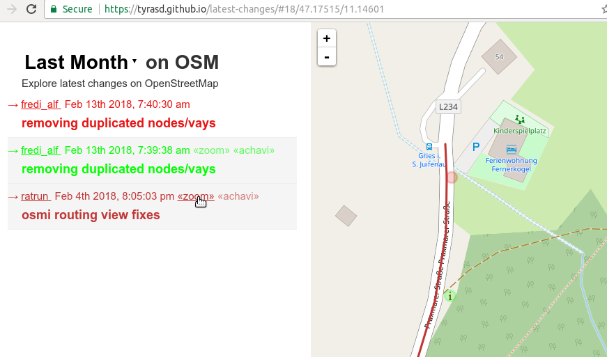
Want to get an idea about what contributions are happening in OSM in your region? Maybe you’re even looking for a way to better review map changes (hint, hint)? A good starting point is probably my latest-edits page tool. It displays all objects that have been modified during the last week alongside with their respective changesets.

One major drawbacks of the tool was that until recently, deleted map objects (and changesets consisting solely of deletions) were not displayed on the page. Now, deleted objects are displayed as faint “ghostly” outlines on the map. In the same way, you can now also see how modified objects looked like before the respective contributions happened. This can result in a nice looking “shadow” effect when for example buildings have been realigned to better aerial imagery.

Also, you can now select between the latest changes from the last day, week, or month, and directly zoom to the location of a particular changeset:

screenshot

See full entry

English: Ayrton Senna da Silva was a Brazilian racing driver (21 March 1960 – 1 May 1994) who won three Formula One world championships for McLaren in 1988, 1990 and 1991, and is widely regarded as one of the greatest Formula One drivers of all time.

Senna used to spend his free time at “Fazenda 2 Lagos” (2 Lakes Farm) in Tatuí - SP, where he built a private karting track, the farm now is run by his parents and brothers since his death in an accident while leading the 1994 San Marino Grand Prix for Williams.

osm.org/#map=16/-23.3075/-47.9371

Português: Ayrton Senna da Silva foi um piloto brasileiro (21 de março de 1960 - 1 de maio de 1994), que ganhou três campeonatos mundiais de Fórmula 1 pela McLaren em 1988, 1990 e 1991, e é amplamente considerado como um dos maiores pilotos de Fórmula 1 de todos os tempos.

Senna costumava passar o tempo livre na “Fazenda 2 Lagos” (2 Lakes Farm) em Tatuí-SP, onde construiu uma pista de karting privada, a fazenda agora é administrada por seus pais e irmãos desde sua morte ocorrida em um acidente, enquanto liderava o Grand Prix de 1994 em São Marino pela Williams.

osm.org/#map=16/-23.3075/-47.9371

Location: Fazenda Dois Lagos - Ayrton Senna, Tatuí, São Paulo, Southeast Region, 18285-901, Brazil
Posted by uzareo on 16 February 2018 in English.

Mission

We live in a world with more and more surveillance, digital and physical, and they have to be fighted. This is project will aim to map the cameras in St. Cugat, and let them be know for the wider public, and through this increase public awareness on the encroaching surveillance state that we are in.

Objective

Map the cameras in Sant Cugat del Valles, and expand further later.

Instructions

Join if you wish, and let me know and we can distribute work.

Posted by omgitsgela on 15 February 2018 in English.

I’m a firm believer that maps are more useful with the more data on them as you can put in. Seems logical, right? When I was looking at OSM, and OsmAnd, it appears that the local functionality of the system as far as address and route guidance is completely useless as of right now, primarily because nothing has addresses entered. It’s great that so much roadway and outlines of buildings have been added, but the map is pretty much useless for the end user who just wants to get from point A to point B.

For this reason, I did some digging and was able to find North Andover’s zoning map, which includes property address numbers! (https://northandoverma.mapgeo.io)

I’ve set out to iterate through all of the addresses I can systematically over time and transfer them all into OSM. I’m sure there’s easier ways… some suggested JOSM with a MassGIS address layer, but JOSM is fairly difficult software to use and I don’t quite understand it yet. So far, I’ve been using iD editor, but that has challenges in that anything over about 100 concurrent edits in the current changeset starts really bogging down the web browser, so I have to save often.

The mission: to update all addresses systematically from west to east, to draw in driveways, and to fix misaligned buildings as I go through.

This is going to take some time.

Location: North Andover, Essex County, Massachusetts, 01845, United States
Posted by bdiscoe on 15 February 2018 in English.

As I’ve been mapping heavily since 2013, I’ve tried various ways to track my progress. It’s really great to feel that your mapping is making a visual and statistical difference! However, as of today, there is no good metric, and it’s very frustrating. Understandably, there is no way at all to measure actual quality or value of contribution across users, because it’s subjective, and users are very different from each other. However, for me, I know that I map at a consistent quality and node density, so I should at least be able to measure my progress with respect to myself! Here are things I’ve tried:

See full entry

This is a volunteer event that will take place at Toowong Library from 09:00 - 13:00 on Sunday 4th of March.

Schedule:

We’ll be mapping throughout the afternoon, in addition to:

09:00: Registration & set-up

09:15: Introduction to OpenStreetMap and the Missing Maps project

09:30: OpenStreetMap/Missing Maps Training

10:00: Snack break (snacks provided!)

10:30: Mapping

11:30: Lunch break

13:00: Wrap-up and farewell

What is it?

The aim of the Missing Maps Project is to map the most crisis-prone parts of the developing world. With your help we can directly improve the lives of some of the planet’s most vulnerable people. Both beginners and experienced mappers are welcome to join this mapathon, please choose your ticket according to your level of mapping skills.

Where will we be mapping?

We will be mapping high priority tasks from the HOT Tasking Manager.

What do I need?

Just a laptop (please bring your own with you), a mouse and enthusiasm (mouse isn’t absolutely necessary but makes the mapping A LOT faster).

Where is it?

We’re very kindly hosted by the Toowong Library, located in Toowong Village Shopping Centre at 9 Sherwood Rd, Toowong, or osm.org/way/529373044 in OpenStreetMap.

Location: Toowong, City of Brisbane, Queensland, 4066, Australia

Taiwan Department of Transport’s public transport exchange platform PTX is quite good on public transport data. It integrates different transport authorities data, for example Taipei City Public Transport Office, New Taipei City Transportation Department, or Directorate General of Highways, bus stop and bus line data. But the export line data from PTX is using Microsoft oData LineString format, programmers.are not familiar with.

But in yesterday’s Taipei Meetup, the keyholder of MozSpace Taipei MingTsay use his ability to help us. He lived deme writing code after discussing with him. He transform the LineString into GeoJson using PHP.

The record is written down on Hackpad. The program that using PHP code is here

The next day I saw the JavaScript Version. MingTsay is quite good at coding. He worked very fast to rewrite to code into other language. Thanks to his effect of his time spending, we could use his program to view the bus line, and view the lineString. I could edit OpenStreetMap bus line at the same time, using the output LineString as GeoJson for reference.

Location: KuanHua Market, Meihua Village, Zhongzheng District, Huashan, Taipei, 100013, Taiwan
Posted by Horza on 12 February 2018 in English.

I’ve been outlining places that haven’t been outlined before and tidying up work done by others where lines aren’t straight or buildings aren’t squared off where they should be. There’s effectively an endless supply of both types of work.

What’s it best to focus on? Do people have preferences? That said, doing more of both has definitely helped with my workflow and knowledge/aptitude with the tools available.

Also, is there a place for open questions like this? I have so many questions about best practice that the wiki doesn’t answer or has ambiguous answers too.