Diary Entries in English

Recent diary entries

Posted by Heather Leson on 8 March 2018 in English. Last updated on 9 March 2018.

Today is International Women’s Day. It is timely that I share notes from our recent OSM and Gender discussion. About 20 women and allies joined to talk about gender issues in OSM. Some of the topics we touched on were: research on gender in OSM, gender experiences, code of conduct and next steps.

Some quotes on why having an OSM and Gender dialogue matters:

“I believe the map represents the world and the contributors to that map should all be representative. “ “Discuss/Learn what to avoid and what to do on regular basis to improve diversity.” “I joined because the tone on the mailing lists is not right.” “I’m part of Geochicas and we work towards having more participation of women in the community. We encourage women to create and be part of mapping projects lead by them.”

Over all, we aim to support a safe and inclusive OSM. This means collaborating with each other and you, the OSM community and the OSM supporters.

What does the data tell us?

Humanitarian OpenStreetMap Team performed a community survey. Of the 267 people who responded, 27% were women. In addition, HOT microgrants/device grants went to 40-45% women.

The YouthMappers community data - We estimate that about 40% of our 5,000 students are female from annual chapter reports. We also see that 25% of our 113 chapters in 35 countries have more than 50% female participation.

See full entry

Location: Kilimani sublocation, Kilimani location, Kilimani ward, Kilimani division, Westlands, Nairobi, Nairobi County, Kenya

“I will do it. I want to do. I wish I will do it one day…” those sentences are not for this team. There is no place for a single performer. It’s a team. Here is not any places for the word ‘I’ without the word ‘We’. They are loves to say “We did it. We had done it.” The team is know that The word ‘We’ is more stronger than ‘I’. But here is a problem is that we don’t want to show the team’s work more than they talks. But by this blog we are wanting to inspire others for a competition of humanitarian work. We are a ultimate ghost. No one know us but feels so much by our works.

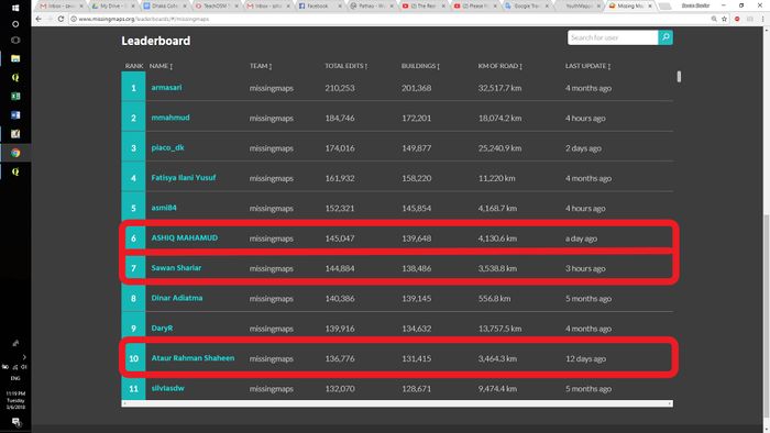
Missingmaps Leaderboard:

See the top 10 mappers of the missingmaps leaderboard. Here staying the three mappers (red marked).And if you see top 50 you will find more mappers of the team. missingmaps leaderboard

YouthMappersBD@Mapillary:

See full entry

Location: Nilkhet, Azimpur, Dhaka, Dhaka Metropolitan, Dhaka District, Dhaka Division, 1209, Bangladesh

Me and my friends founded a help organization in Banfora (Burkina Faso) called FANGA e.V. in 2010.

www.fanga-ev.de

We help children and young people of the poorest families in Banfora with school and job education and medical support.

One problem for us is that these families are scattered all over the town of Banfora (about 80’000 people) and our staff struggles to find the homes because there are almost no street names and house numbers.

That’s why we startet GPS tracking and OSM mapping a couple of years ago. We mapped now almost all streets in Banfora, but it is still quite difficult on the ground with a printed map or on a phone to find the right buildings in the chaotic slums with no roads between the buildings.

So we contacted the HOT Team and together we are mapping now all buildings in Banfora. Take a look: https://tasks.hotosm.org/project/4106?task=370

Location: Bounouma, Banfora, Comoé, Waterfalls, Burkina Faso

The call for nominations for the OSM Awards de 2018 is now open it the winners will be presented during the SOTM en Milano, Italy at the end of July.

While this is a fairly new initiative to celebrate the achievements of people, groups and projects that support OpenStreetMap, I couldn’t but notice the fact that in this two years, in all categories the percentage of women nominations is really inferior than men nominations.

This are the initial categories (Each category holds 5 nominatios):

  • Core Systems Award
  • Innovation Award
  • Influential Writing Award
  • Greatness in Mapping Award
  • Expanding the Community Award
  • Ulf Möller Memorial Award

For the [OpenStreetMap Awards 2016] (osm.wiki/OpenStreetMap_Awards/2016), out of 30 nominations, only 3 women were nominated (none for the Greatness in Mapping Award); for the [OpenStreetMap Awards 2017] (osm.wiki/OpenStreetMap_Awards/2017), where there were more awards (added: Improving the Latin America Award, Improving the Africa Award, Improving the Asia Award ) only 5 women were nominated.

Now, regarding to the winners, in 2016, [no women] (https://blog.openstreetmap.org/2016/09/26/we-have-our-winners/) won an award; in 2017, [Geochicas] (https://twitter.com/Srta_Peperina/status/898868046617427969) were the only women who won an award. (A disclaimer about this, groups where there was participation of women did win, however no award - apart from ours - was obtained by a woman or a group led or conformed only by women).

See full entry

Location: Jorge Dimitrov, District I, Managua, 11129, Nicaragua

image Happy to see folks from various communities coming together to celebrate ODD with us.
Last Saturday afternoon, we celebrated Open Data Day 2018 in PUP San Juan, with several volunteers from OpenStreetMap Philippines and the local FOSS4G chapter facilitating the parallel workshop sessions we ran.

See full entry

Location: Addition Hills, 2nd District, San Juan, Eastern Manila District, Metro Manila, Philippines

There are thousand of kilometers of 735KV power lines over the Quebec territory. There are often trails under these lines and road crossings. While monitoring the edits to these power lines today, I realized that many contributors had again connected roads to the power lines.

Let me describe this interesting case.

Risks of editing nearby high voltage power lines

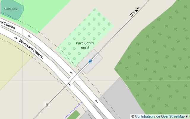
A few years ago, a dog park was added plus a nearby parking under a 735KV power line. On the nearby boulevard, the connecting segment between the two sides of the road was moved closed to the Power line and clipped to it. Then a road navigation specialist working for an OSM partner company did narrowly edit modifying highway=tertiary to highway=tertiary_link.

Those people should look around. It is quite dangerous to edit this way. If QA is done so automatically by humans, should we add some artficial intelligence in the editors to detect such problems, and why not give a mild electric shock to contributors!

See full entry

Location: 45.698, -73.897
Posted by apm-wa on 4 March 2018 in English.

March 1-2 I traveled to Yoloten and Mary, and passed through Tejen, and tried to collect ground-level Mapillary imagery…during and after a rain storm (unusual in arid Turkmenistan, but not unknown in winter). I must apologize for the poor quality imagery. It was just too dark and gloomy. I collected some useful data and have added information to the maps of Yoloten, Mary, and Tejen (including Tejen’s only hotel, which charges 6 manat or $1.71 per night). Nonetheless some of the imagery is less than marginal. Sorry! At least I added some street names to these towns, as well as some major POIs.

Today Ann and I cruised the former vilage of Gokje, now officially a neighborhood of Ashgabat since it was annexed, and collected street names, POIs, and fresh GPS traces for streets that have been created in the past year or so. Some streets had absolutely no signage at all. Not sure how we’ll find the names for them.

Location: Bozýatan, Yoloten District, Mary Region, 746420, Turkmenistan
Posted by bdiscoe on 3 March 2018 in English.

I’ve run my find_small_displacements program on Japan, and found some problematic imports with a large number of densely overnoded features, here are some:

  1. Bad import of natural=wood around Fukuoka. These were tightly spaced, yet also wildly inaccurate, off by as much as 80 meters and covering lots of non-wood areas, even covering motorways. I’ve reduced most of them, and aligned a few areas, but there’s lots more to align. The original upload was in 2010 with changesets like this one.

  2. Bad waterways, especially in Hokkaido and Kyushu, but also across the country; these are not just overnoded but also overtagged, consider this little stream near Taketa, Ōita:

  • KSJ2:COP_label=1級指定区間
  • KSJ2:DFD=流下方向不明
  • KSJ2:LOC=c03671
  • KSJ2:RIC=8909180118
  • KSJ2:RIN=軸丸川
  • KSJ2:WSC=890918
  • KSJ2:curve_id=c03671
  • KSJ2:filename=W05-07_44.xml
  • KSJ2:river_id=gb02_03671
  • layer=-1
  • name:ja=軸丸川
  • name=軸丸川
  • note:ja=国土数値情報(河川データ)平成18年国土交通省
  • note=National-Land Numerical Information (River) 2006, MLIT Japan
  • source=KSJ2
  • source_ref=http://nlftp.mlit.go.jp/ksj/jpgis/datalist/KsjTmplt-W05.html
  • waterway=river

See full entry

Posted by bdiscoe on 3 March 2018 in English.

To follow up from my previous post, I did some further work on generating and putting online a table of OSM node/way ranks table

The data that’s there right now is from today (2018-03-01) and the deltas are vs. 2 weeks ago (2018-02-12).

Standard disclaimer: Last-modified-rank is only vaguely related to contribution, there is no way at all to measure actual quality or value of contribution across users, because it’s subjective, and users are very different from each other. However, this table can be very useful for an individual mapper to see how their amount of contribution changes over time, and to identify, for example, accounts that are moving up rapidly which usually indicates they are doing an import. Similarly, if your rank moves down, it can mean that someone (correctly or not) has modified or deleted your mapping work.

For those curious about the technical mess that’s currently involved, here is what I did:

See full entry

Posted by rinigus on 28 February 2018 in English.

After more than a year of development and 38 releases, I would like to give an update on the status of OSM Scout Server. The server is targeting mobile Linux devices as a drop-in replacement for online map services providing map tiles, search, and routing. As a result, an offline operation is possible if the device has a server and map client programs installed and running. Since its tailored towards mobile devices, the server has been successfully used on devices with as little as 1-2 GB of RAM.

At present, the server can be used to provide:

  • vector or raster tiles for other applications;
  • search for locations and free text search;
  • search for POIs next to a reference area;
  • calculating routes between given sequence of points.

User’s guide is available at https://rinigus.github.io/osmscout-server that describes how to set it up for Sailfish OS.

While started as a wrapper to libosmscout, it now incorporates several other backends:

See full entry

Changeset details: osm.org/changeset/56642302

The Central Park Mall is one of the popular shopping malls in West Jakarta, Indonesia. It is also inspired by the design of the Central Park in New York City.

This mall has a park for visitors to walk around, called the Tribeca Park. Aside from that, this mall is also connected to the Tribeca (a 2-storey section of Central Park Mall consisting of several restaurants) and Neo Soho (the shopping mall below the new Soho apartment near to Central Park). These malls are owned by the same developer, PT. Agung Podomoro Land.

In this changeset I added the new Tribeca (mall) section at the other side of Tribeca Park, including the skybridge connecting Tribeca ↔️ Central Park ↔️ Neo Soho. I also added more details on Tribeca Park itself, including added new footpaths, restaurants, ponds, fountains and a new escalator. There’s 1 more pond left unmapped, as I need to re-check on site for the accuracy of its position.

So far, here’s the changes I made to this shopping mall. As of now, there might be some mistakes in my changes to, which I will fix it later.

See full entry

Location: RW 06, Tanjung Duren Selatan, Grogol Petamburan, West Jakarta, Special Capital Region of Jakarta, Java, Indonesia
Posted by ConsEbt on 24 February 2018 in English.

Hi everybody, I’m looking for suggestions to improve the tagging of the Surf House Dubai which I have https://www.openstreetmap.org/changeset/56642023.

Now I did add some tags to the surf shop as suggested by the wiki however I’d like to have some comments.

  • how should sale and renting of surf, wake and stand up paddling boards be tagged?
  • how to add the surf school?
  • how to add the surf shop - they sell board, parts, tee shirts, shorts, sunglasses, sunscreen etc.
  • how to add Yoga classes

What are your suggestions?

Location: Umm Suqeim, Dubai, United Arab Emirates
Posted by Adam Heinz on 24 February 2018 in English.

Lots of global companies use OpenStreetMap. Take Strava, for example:

The Strava Global Heat map shows cycling activity around the world, including Christchurch. ( https://labs.strava.com/heatmap/#12.00/172.58547/-43.50785/hot/ride ).

The road lines are based on OpenStreetMap ( https://medium.com/strava-engineering/get-on-the-map-dca5d2693c37 ).

By improving OpenStreetMap we can ensure that our fellow citizens are making decisions based on accurate information provided through 3rd-party providers.

Location: Christchurch Central, Linwood-Central-Heathcote Community, Christchurch City, Canterbury, 8011, New Zealand