 OpenStreetMap

Started mapping today. Nothing to grandiose. Fixed some streets in my city and added/fixed a few buildings and parks. It will take time, but I intend to fully map my area.
Diary Entries in English
Recent diary entries
Posted by TagaSanPedroAko on 16 January 2018 in English.

Once again, Batangas City’s map is growing again with updates, particularly on mapping building floors, addresses and names, missing buildings and POI’s, and land use zones.
Buildings
In order to improve 3D renderings of the city’s buildings, especially those in the Poblacion, number of floors are being added through on the ground work using Maps.me. In addition, tagging of building addresses are also done, as there are many buildings with known addresses that can be sighted on outdoor signage. Building numbering also exists, but not all buildings indicate them. Names of buildings are also one part of building map improvements, as the building name form one part of many POI addresses.
Not only missing building details are added, but also many missing buildings constructed or existent since the past year. I mapped new houses and apartments inside Duluhan in Cuta, and a new commercial building along Lt. Col. D. Atienza Street. Building remapping is also done to redraw buildings that does not align properly with the most recent images. As part of this, the building occupied by Novo Department Store is remapped using DigitalGlobe Standard imagery and physical survey.
Points of interest
Many POIs scattered on the urbanized Poblacion and Cuta areas are being added one by one, also on the ground using Maps.me.
Land use zones

Now that I have been editing OSM’s Turkmenistan map for nearly three years, I feel confident enough to offer a suggested set of administrative levels. I invite one and all to take a look at my proposal at osm.wiki/Template:Admin_level_11 and offer constructive feedback. This proposal is based on my by now fairly good knowledge of the political structure of Turkmenistan and the way the hierarchy works.
The last two days have been fairly productive. Ann and I went exploring neighorhoods in Gypjak, Choganly, Taze Eyyam, and Taze Zaman where we were missing street names, numbers of schools, and such. We mostly filled in blanks in the map but also updated some streets in Taze Eyyam plus added a few in the new subdivision being built on the west side of Choganly. We visited the unidentified neighborhood on the northwest corner of the demolished former Ruhabat dacha community, which has absolutely no signs, but asked locals what it is called. They identified it as Galkynysh (Turkmen for “renaissance”), a neighborhood subordinate to the Choganly jurisdiction, which is part of the city of Ashgabat.
The Ruhabat dacha community is definitely gone. We drove through part of the territory, and crews were there watering saplings that have been planted where old imagery shows a dacha community.
Posted by Pieter Vander Vennet on 14 January 2018 in English.
Last updated on 24 July 2018.

I’m from Bruges (Belgium). You know, that famous medieval city in Belgium.
As everyone in Belgium knows, the center of Bruges is paved mostly in sett/cobblestones. Personally, I’m pretty fond of those sett pavements. They’re way nicer to see then asphalt (not to mention conrete plates), the absorb a lot of heat in the summer (cooling the city) which is released again in autumn.
But, as the bicycle is my primary means of transportation, one drawback comes to mind: they’re uncomfortable to cycle on - especially when pulling a cart. Some types of set pavement are to be avoided then - I’d rather drive 200 meters over asphalt than 100 over the big boulder. However, the smaller sett -often laid in arcs- is more comfortable to drive on and has a smaller penalty.
This implies that more information should be added to the ‘surface’-tag. In this document, I propose a few extra tags to deal with this extra information; and what kind of sett these are. These tags are used in Bruges; feel free to use them in other places as well.
All example pictures are taken by me, and may be used freely for OSM-related endeavours (e.g. wiki, tools, …).
Cobblestone vs. Sett
First things first.. What is sett stone? And what are cobblestones?
According to Wikipedia, Cobblestone is a natural building material based on cobble-sized stones, and is used for pavement roads, streets, and buildings. Sett is distinct from a cobblestone by being quarried or shaped to a regular form, whereas cobblestone is generally of a naturally occurring form.
In practice, cobblestone is often used in OSM to describe sett stones - although incorrectly. The wiki itself acknowledges this:

Last week, we shared a a tasking project to update missing highways in Metro Manila 0 in the local mailing list. We’ve also published a few more tasks to cover adjacent provinces:
The data is not perfect, and you may even encounter false positives, but it’s pretty good with pointing out a good number of missing roads in essential areas that local mappers have yet to digitize.
These are all part of the on-going initiatives by Kaart, to make awesome data for PH, and help grow local mapping communities.
If you’re keen on improving the map of your home town or province, and they’re not on this list yet, please let me know so I can put them up sooner rather than later, and we can work together in filling-in gaps in your favorite neighborhoods.
How about a mapa-thon soon? I’m planning to organize one, primarily to work on these tasks, and for the community to meet each other, and maybe welcome new ones. Would you folks have any suggestions, or is your org interested in collaborating? Let me know.
See all the Missing Highways tasks in PH. Do email me for any concern, or other questions, about these tasks.
Short, but sweet.
Great news today in regards to rail (United Kingdom). I have been in contact with Network Rail and have received permission to use the information within the Sectional Appendix or NESA to share rail data including speed limits, references, codes and restrictions. The only condition was that it needs to be attributed to ‘Network Rail’.
I have various FOI requests currently in progress like TIPLOC latitude and longitudes which is useful for stations but also junction locations. Hopefully, signal locations too (most likely a no to that one due to potential theft and damage).
Posted by grass_and_green on 11 January 2018 in English.

Dear All,

The dialogue of the Openstreetmap LATAM community in the channels used (chats, lists, forums, events) has revealed a very low female participation and the need to develop a general and permanent reflection on gender in this community.
Staring 2016, with this objective, a group of 10 female mappers (Geochicas) has been formed within the community, who dedicate a particular effort to help the development of this debate, in addition to mapping activities directed by and toward women with a gender perspective. One of the channels for this debate is through the organization of panels for reflection and discussion at each event of the OpenStreetMap community (State of the Map) and different events in communities related to technologies and open data.


Ever wanted documentation of OSM tags in your own language?
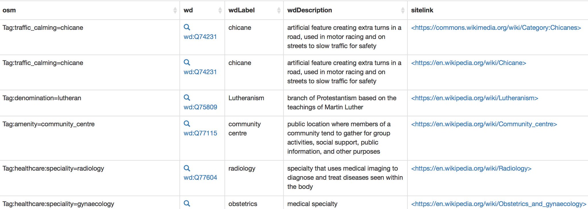
Thanks to Wikidata, this might be quite simple: OSM tags in Japanese | German | English
(Hit edit query to change to your language)
If you find a missing tag or translation, you can add it by editing the relevant Wikidata item and adding a new translation or a new OSM tag property.
The post was inspired by a recent discussion on OSM wiki questioning the value of Wikidata links on the wiki pages. Atleast in my part of the world, this is going to be quite useful since the Wiki pages have not been translated into my language.
Note It is known that OSM tags don’t always map 1:1 exactly with existing Wikidata concepts and such derived definitions need further review to make sure it is consistent with the OSM Wiki. In such cases a new concept can be created in Wikidata if it does not overlap with any existing definition.
Posted by chandusekharreddy on 10 January 2018 in English.
Steps to follow Import Boundaries using JOSM Create Relation for each boundary, copy details like name, ref etc to relation Split Boundary
After splitting boundaries search any closed polygon is there to cross check, if any split them. Only once we have to split closed boundary. Remaining splits at ‘T’ junctions can be under using split adjacent ways under more tools. Validate the features, this will give you overlapping features. Merge duplicate ways and keep the relations.

It’s a new year and we have some new features in OSMCha!!! Let’s take a look on them:
Save filter UI improved

Now it’s easier to save a filter! After set your filter parameters, click on the Save button on the top of the screen, give a name to it and press the Confirm Save button. The filter will be saved and applied, so the sidebar will update with the results. If you want to change something in your filter later, repeat those steps. Remember that the filters have a RSS feed. Get the link in your OSMCha user page.
Changeset comments

These are the most frequently used opening hours for museums and other art related features in OSM. Apparently, most are closed on Mondays, or do not close any particular day: count value
263 Tu-Su 10:00-18:00
199 Tu-Su 10:00-17:00
186 24/7
175 unknown
144 Mo-Su 10:00-18:00
119 Mo-Su 09:00-17:00
110 Mo-Su 10:00-17:00
87 Tu-Su 09:00-17:00
67 10:00-18:00
63 10:00-17:00
61 closed
60 9:00-17:00; Mo closed
59 Tu-Su 11:00-17:00
52 9:00-17:00
50 Mo-Su 09:00-18:00
48 Tu-Su 11:00-18:00
43 09:00-17:00
43 Mo-Fr 09:00-17:00
42 Tu-Sa 10:00-17:00
40 Mo-Su 10:00-20:00
40 Su 14:00-17:00
39 Mo-Su 10:00-19:00
38 Tu-Su 09:00-18:00
38 We-Su 10:00-18:00
33 Tu-Su 10:00-16:00
30 “on appointment”
30 Tu-Sa 10:00-18:00

Over the past week there has been a very long and detailed conservation about tagging parks and conservation land on the talk-us email list. This is a topic of great interest to me, but, the emails have reminded me of the fact that attempting to model everything on earth as an XML file is ultimately futile. Happily, this contradiction built into the OSM seems to insure that the project stays alive and vital over the long term. There is always room for improvement, the map can’t ever be completed. The XML file is never going to be 100% right.
Posted by SimonPoole on 7 January 2018 in English.
Last updated on 13 October 2018.

I’ve updated, as every quarter, the statistics on our wiki.
One thing we can see on
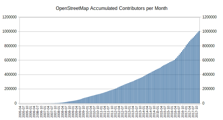
is what looks like growth flattening out.
Splitting out the new contributors from maps.me and other sources gives us the following graph:
In November, the Turkmen parliament (Mejlis) restored the former name “Kerki” to the town of Atamyrat. I have restored Kerki to the town and its rail station. This week the parliament restored the name “Bäherden” to Baharly. I have changed it, too. It is not clear why the names were changed in the first place, though Atamyrat Niyazov was the father of Turkmenistan’s first president, and perhaps Kerki was renamed in his honor at one point. Why Baherden was changed to Baharly some time ago is even less clear.
Here are the notifications in Russian of restoration of the former names:

OpenStreetMap US is hiring an Executive Director, and they are looking to build a hiring committee:
We are thus inviting community members (YOU) to self-nominate if you are interested in participating in the hiring process. … If you are interested in nominating yourself, expressions of interest will be accepted by email (to hiring@openstreetmap.us) until January 12th, 2018.
I’m interested, so I sent the email below.
Hello,
I would like to participate in the Executive Director hiring process as part of the 7-person committee! I’m pretty sure I know a few of the people who might be reading this email, but I thought I’d make it a more formal one to underscore my interest in helping.
I enthusiastically support the idea of finding a leader for OSM US at this time. The US Foundation has consistently been on the cutting edge of international OSM work, from hosting the most consistently well-produced regional conferences to pioneering advances in OSM’s use for disaster response and international development. OpenStreetMap needs a way to communicate with the many organizations whose mission or business depends on it, and hiring a full-time ED will help this happen.
OSM as a whole is experiencing rapid change, and faces both risks and opportunities I wrote about in this widely-shared blog post last year: http://mike.teczno.com/notes/openstreetmap-at-a-crossroads.html
As a long-time participant in open source and non-profit technology efforts, I bring experience and perspective that will help ensure a good process and result. I’m on the boards of mapping non-profits GreenInfo Network and Digital Democracy, I served as CTO of government technology non-profit Code For America for three years, and I’m currently Executive Director for a new non-profit political mapping project, PlanScore.org.
I spent a little while the last two evenings using the new Digital Globe Premium Imagery for Turkmenistan to clean up some parts of Ashgabat plus areas in the far southeast I visited some months back but was unable to map in detail. This new imagery is terrific. I corrected some rail lines and added rail spurs to factories I either visited or rode past, plus added streets. This is good stuff.

Today I interviewed some embassy staffers about the status of the Ruhabat dacha community, which appeared on the OSM map of Ashgabat north of the Altyn Asyr (“new Tolkuchka”) bazaar. I have driven past it many times and never seen a house there, but the map shows a significant residential community. It turns out the Turkmen government ordered the entire community demolished in 2013, and by mid-2014 (before I arrived here) it had been eradicated. All houses were torn down and the rubble removed, ostensibly to make way for a new airport and zoological garden, neither of which was built there (the existing airport was expanded, and the zoo was moved to a new site southwest of the city).
I thus removed the point marker for the “town” of Ruhabat, since it has not existed for over three years, and redrew the outlines of the “neighborhood” to correspond to a small village on the northwest corner of the former Ruhabat community. I will have to drive up there to see if that community has a name.
Mapping my neighboorhood, mostly in Otsego