Diary Entries in English

Recent diary entries

OpenStreetMap Notes make it easy to share some info about mistakes or missing data in OpenStreetMap. It’s a very open system, allowing for posting and commenting from third party apps and even without logging in.

I’m working on an exhaustive analysis of how notes are used. Here are some prelimanry findings.

Notes are often personal

While the wiki doesn’t encourage using Notes as a personal to-do list, very many Notes get closed by the original poster. In fact, of all Notes that were posted by a logged in contributor, that are at least 90 days old, and are already closed, 50% were closed by the original mapper. The vast majority of those “self-closed” Notes (96%), never saw interaction. Notable though, is that IF there was some sort of interaction, there was a reaction by the original contributor in almost 90% of the cases.

One of the things that I want to investigate, is if these people who are closing so many of their own Notes, are also up to closing other Notes. What I would like to know is if the Maps.me surge in Notes created more note-closers, and if so if they were new to notes or not.

Maps.me is huge

When Maps.me implemented Notes into their app, the impact was huge. Basically, the number of Notes doubled overnight. The graph shows the monthly opened notes. In the first months of Maps.me Notes, the added notes were about the same as all other notes together!

See full entry

Ann and I celebrated New Year’s Day by taking advantage of the low level of traffic (many revelers evidently slept in) to explore a previously unmapped industrial road southeast of Abadan that serves a large gravel quarry. We collected both GPS traces and Mapillary imagery, and then proceeded northward to collect more street names in Abadan. We also collected some POIs in Köşi, specifically numbers assigned to schools and kindergartens. This is a particular interest of mine since, in the event of a major earthquake, the schools and kindergartens will likely be used as emergency shelters and rally points, and thus places to look for survivors.

We corrected some streets (one mapped as a through street in reality dead ends at what appears to be a school house, for example) and hunted down some streets signs. All in all, we had a moderately productive afternoon, and a pleasant drive.

Another section of Köşi has been demolished, to the north and south of the extension of Magtymguly şaýoly that was extended westward a few months ago. Houses either have been torn down or are in process of demolition. It is not clear what is next for that neighborhood. I removed buildings from OSM that no longer exist, based on this ground truth, and collected some Mapillary imagery to corroborate.

Location: Buzmeyin, Ashgabat, 745220, Turkmenistan
Posted by LorenzoStucchi on 31 December 2017 in English.

During December with PolimappersAdventures I discovered lot of new features and I have mapped simple but useful ones, that I don’t know before, in my small town. From this feature we will try to improve the map with the knowledge of the importance of the wiki.

Thanks to all who participated and map.

Location: Cascina Gazzulo, Sulbiate, Monza and Brianza, Lombardy, 20883, Italy

The Journey

In early 2017 a group of active members from OpenStreetMap Bangladesh Community (OSMBD) decided to form an unofficial entity BOIL (Bangladesh Open Innovation Lab) to utilize the huge & diverse potential of crowdsourced OpenStreetMap data and take the Open Data movement forward. The decision was made to coordinate the community activities in a more structured way and bring out the best from the members of this community. Immediately, BHOOT (Bangladesh Humanitarian OpenStreetMap Operations Team) was formed as a initiative of BOIL to support HOT (Humanitarian OpenStreetMap Team) with all their activations supporting all the disasters & emergency humanitarian crisis throughout the globe including Bangladesh.

In Bangladesh BHOOT(vut) stands for Ghost, the entity you cannot see in front of your eyes but surely can feel its presence and works. However, the group vowed to make the impact remaining behind the scene and not really bother focusing to become the poster boys of the community. And, literally they made the impact with a big bang!

Collaborating with Pathao with “Map Your City” project, leading the “South Asian Flood Activation (Bangladesh part)” by HOT, supporting “Rohingya Population Movement Mapping” by MissingMaps… 2017 was a very busy and eventful first year for the BHOOT’s. With adding more than 2 Million buildings, 2000 km roads & 150k street view images from Bangladesh region on the OpenStreetMap, surely they made the community moved & evolved. Eventually the team almost single handedly taken the size of the zipped data size of Bangladesh region from 22 MB to 93 MB in only 06 months! The humongous contribution made 05 members of the team reaching the top 10 position in Missing Maps global contributor’s leaderboard and another 15 placed in top 100 of that leaderboard!

The Community

See full entry

Posted by Dzertanoj on 29 December 2017 in English. Last updated on 18 January 2018.

Being a distributed crowdsourced project, OSM strongly depends on communication channels to bring the desired level of coordination within communities. However, since there is a high level of independence and autonomy in these communities, it might lead to a situation of scattered and fragmented communication. I’m not proposing anything here, but I still want to bring this issue to attention.

Every technology used for communication (mailing lists, forums, messenger channels, IRC) might have a certain advantage over others, but the thing is that it has nothing to do with its popularity. The dominance of a certain channel within a community has historical roots and relies on a habit. An existing choice might have a justification, but that is not a reason for a particular choice. For example, why Russian-speaking community prefers forum over the mailing lists? Just because several people started using it many years ago. It’s not because it’s easier to search through it or because it has better message formatting features. But there is nothing wrong with it. However, there is one significant bad side.

Commonly used communication channel might get a “fork” just because several people (or even a single person) want to take over it or just because they have different habits. That’s exactly what happened in Russian-speaking community starting a Telegram messenger channel. Those who don’t want to use Telegram or who prefer non-real-time communication (forum or mailing list) over a real-time chat technology, become deprived of a significant part of a communication process.

See full entry

Posted by SomeoneElse on 29 December 2017 in English. Last updated on 31 January 2018.

There’s a discussion over on talk about contributions to OSM’s Standard map style. This diary entry explains what I did in order for a change to fix a problem with bus guideways that was visible in that style. It’s provided here so that hopefully it can help more people that want to (but don’t necessarily know how to) to contribute.

The first thing I did was log an issue for the problem that needed to be fixed. As well as describing the problem that also outlined the fix (actually I referenced some code in a different map style where I’d already fixed the problem). The initial discussion on the issue was helpful in that other people said that yes, they thought that it was a problem too.

However, describing the problem is only part of the way towards actually fixing it. In order to do that, I started by reading the “contributing” guidelines and the links from there.

I already had a github account. I forked OSM Carto into my area to create this. Within there, I created a new branch “guideways_low_zoom” (since deleted) just by typing the name in into the github UI.

I already had a virtual machine running Ubuntu 16.04.3 LTS (server) with all the pre-requisites in place. I’d set it up as per the switch2osm guide, but mainly use it for developing a different map style based on an older version of OSM Carto. Another option is to follow the recommendation in the OSM Carto repository and use Docker.

I then had to “git clone” my forked repository to set it up on that machine, and I then did:

git fetch --all
git checkout --track origin/guideways_low_zoom

to get the correct branch there.

In order to actually get the vanilla copy of OSM Carto working, I had to follow the instructions in the “Shapefile download” section of the switch2osm instructions (essentially running “scripts/get-shapefiles.py”).

See full entry

Reflections on 10 years of a changing Open Source Map

It was ten years ago today that I registered to map the highway!

With apologies to the Beatles, on 2007-12-28, I registered an account with OSM, started editing the map, and after returning from Falkirk to Cramlington, uploaded my first GPS survey data.

The map has changed rather a lot in that time, and not just in completeness, but in the diversity of the usage of OSM data. I was surprised a few years ago when visiting Lichfield that the Council was using OSM to show car parks, but shouldn’t have been surprised at all when preparing for a walk up Simonside when the Forestry Commission linked to an OSM map based in a small way on my previous visit!

See full entry

Location: Cramlington, Northumberland, North East, England, United Kingdom

Eastern University and OpenStreetMap (OSM) Bangladesh Community organized a daylong event on “Workshop on MapillaryBangladesh” held on December 15, 2017 at Eastern University Seminar Hall. More than hundred enthusiastic Mappers from OSM Bangladesh Community, Mapillay Bangladesh Community, YouthMappers Chapters in Bangladesh, and students of EU participated in the workshop.

Mr. Edoardo Neerhut, Community Manager, Mapillary graced the workshop with his presence as the Chief Guest. Prof. Sheikh Tawhidul Islam, Director, Institute of Remote Sensing, Jahangirnagar University was the special guest. Prof. Dr. Md. Mahfuzur Rahman, Dean, Faculty of Engineering and Technology, Eastern University, presided over the session.Dr. Ishtiaq Ahmed, Assistant Professor, University of Toronto, Canada delivered his speech to share his views with the audience.

The workshop started with the welcome speech by Mr. Ahasanul Hoque, Vice President, Humanitarian OSM Team. Mr. Hoque presented OSM Bangladesh and current status of Mapillary and gave some guideline for future mappers. In his motivating speech the session chairProf. Dr. Md. Mahfuzur Rahman mentioned that volunteering task is very important for students for their future. He also mentioned that in 1971, our victory was achieved by the volunteering initiative, Freedom Fighters were not paid. The Chief Guest of the workshop Mr. Edoardo Neerhut, showed details of Mapillary works, application and future plan of Mapillary. He was delighted to see the enthusiasm, hard work andinherent talentof the mappers.

See full entry

Location: Lake Circus, Kolabagan, Dhaka, Dhaka Metropolitan, Dhaka District, Dhaka Division, 1215, Bangladesh

Batangas City’s map is slowly growing and updated, thanks to having MAPS.ME and imagery by DigitalGlobe through their API. Much efforts are on local updates, and an ongoing effort to map Meralco’s power network and public transport is being followed up, but most mapping is related to the local vicinity, especially POI’s

Local updates

Thanks for having Maps.Me, many POIs, particularly those in the Poblacion, can be added now while on the ground, and notes can be created at the same time, with uploading to the OSM database done when now connected to the Internet through WiFi, such as at home, on Plaza Mabini (which has public WiFi provided by Globe Telecom’s GoWiFi), or at the malls with free WiFi (such as SM City Batangas and Bay Mall, though the former has time-limited WiFi service).

Upon hearing of an area around Calicanto called “Lawas”, I soon added a note for it around the area called as such.

One latest update is a future bridge between Ferry, Kumintang Ibaba, and Gulod Labac, which I added to OSM after hearing the news of such construction during the All Saints’ Day vacation. The bridge is now mapped here as this

Being least detailed over the area along Route 436, I made some mapping of Lourdes Subdivision in Bolbok after attending a funeral service in Mt. Zion Memorial Park. I added a school (Princeton Science School), a home-based ‘‘lomi’’ restaurant, and a small Christian church, which is shown in this changeset. Further changes, like naming a street on the same area, adding an annex campus of a public school (Bolbok Elementary School), and correction the location of Princeton Science School, are done after returning back to Batangas City for Christmas.

See full entry

Location: Duluhan, Cuta, Batangas City, Batangas, Calabarzon, 4200, Philippines

I went to my home town Kanchipuram, India for Christmas holidays. We had a good active Linux Users Group called KanchiLUG there few years ago. We still have few members there doing nice works there.

Decided to have a mini mapping party at kanchipuram on Dec 25, 2017. sent a mail to our mailing list and asked people to join the party. https://www.freelists.org/post/kanchilug/OpenStreetsMaps-Mapping-Party-Dec-25-101

We had one volunteer replied. T. Dhanasekar. We met on dec 25 10 am. Created an account for him in openstreetmaps.

We both dont use smartphone. I borrowed my wife Nithya’s phone. He did not get any. I dont have a motor bike there. I already took his bike. Hence, we decided to roam around the city together and add interesting places to OSM.

I explained maps.me app and how to add POI. We found many schools, temples, shops, clinics etc and added them. For few POI’s, we did not find suitable types in maps.me

Will ask the maps.me team to add more types.

In 2 hours, we added 75 places. There are still tons of places to add at Kanchipuram. We will add them in upcoming days.

Location: 12.835, 79.693
Posted by Zverik on 25 December 2017 in English.

Last week we published the latest version of Maps.Me. It’s got the major version number increase — 8.0. And not for nothing: there is a brand new “Discovery” button, which shows interesting places around you. There are christmas markets on the map — not from OSM though. You can register as a “local guide”, meet new people and show them around your city. Hotels from booking.com can be filtered by price, rating and availability.

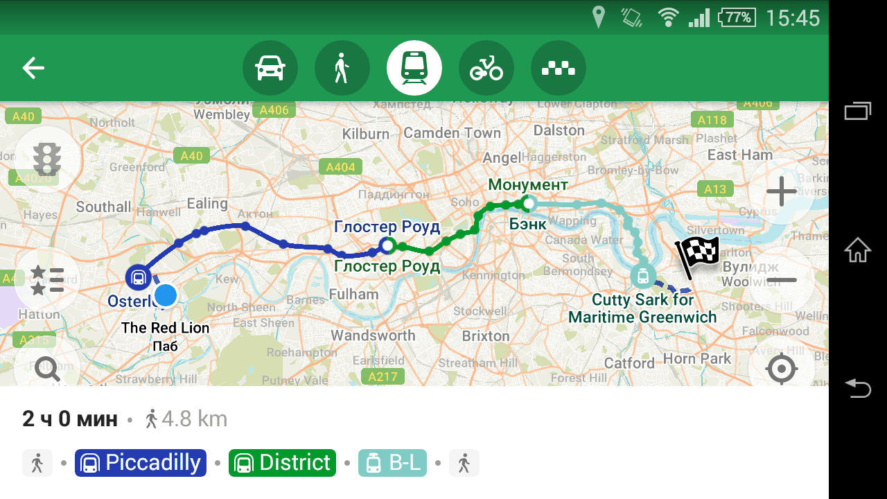
But that is not why the release is worth celebrating. The main thing is, we’ve made a metro routing!

Screenshot of an Underground route in London

It won’t be an exaggeration to say that this is the first even public transport routing application that uses solely OpenStreetMap data. Anybody can employ GTFS data, but using OSM is not that easy. All these relations — “route”, “route_master”, “stop_area”, with enourmous tables in the wiki detailing their usage. Utter mess in the data, a result of mapping for a renderer. Very few people understand public transport mapping, so how did we even use it?

See full entry

Posted by Diego Sanguinetti on 24 December 2017 in English.

Greetings to all. I wish you a Merry Christmas and New Year for those who are participating in Openstreetmap.

This week I had to correct some points in the Metro de Lima (Linea 1), after what I found from maps.me. These improvements are related to the station, the stops and the sections of the Metro.

The details you can find in the history of:

Location: Bayóvar, San Juan de Lurigancho, Province of Lima, Lima Metropolitan Area, Lima, 15423, Peru
Posted by apm-wa on 23 December 2017 in English. Last updated on 25 May 2019.

I spent a couple of weeks in Rosslyn, Virginia, on vacation, and stumbled across a sign identifying the site of the building where the U.S. Defense Department’s Advanced Research Projects Agency (ARPA) invented the network and first attendant protocols, ARPANet, that are today known as the Internet. I photographed the sign and uploaded it to Mapillary, which for some reason has placed it incorrectly (I’m trying to move it to the correct location but Mapillary advises it “may take some time.”)

ARPANet sign on SE corner of North Oak Street and Clarendon Boulevard in Arlington, Virginia

Can anybody tell me what the binary code on the back of the sign means?

See full entry

Location: Rosslyn, Arlington, Arlington County, Virginia, 22209, United States
Posted by IknowJoseph on 23 December 2017 in English.

GraphHopper will now route cars over fords recorded in OSM, as confirmed here.

I was aware of this when the change was made because I’ve been keeping track of the GraphHopper driving distance from N’Djamena to Mongo, a route that is something like this:

GraphHopper graph

The sudden rise in distance was caused by a mapper adding a ford between the two places; the drop is when GraphHopper started to route across it.

More details on the recording of routes to follow; for now I just wanted to show this practical usage example.

Location: Abingdon on Thames, Vale of White Horse, Oxfordshire, England, United Kingdom