Diary Entries in English

Recent diary entries

This is my position statement for the December 2017 board election.

Where I’m coming from

Since joining OpenStreetMap, I’ve found myself on a slippery slope of ever stronger engagement to the project. Not only have I been mapping at least every other day, I’ve grown into being a community organizer. At first I was mostly interested in South America, where it felt like OSM has a much larger niche to fill than in Europe. I didn’t start off as an open source and open data enthusiast, but as someone crazy about maps. As a sociologist and data analyst I was fascinated by the data and the people behind it. I liked the way OpenStreetMap could solve real problems, and enjoyed being part of those solutions. Riding on the tails of Jorieke Vyncke (current Missing Maps coordinator) and Ben Abelshausen (awesome OSM routing developer and tireless organizer), it always seemed logical that we should build the map together.

See full entry

Posted by SimonPoole on 15 November 2017 in English. Last updated on 22 November 2017.

With the last release 0.9.9 running nice and stable and the monthly updates to it contain mostly updated presets and imagery configurations, it is time to give you a preview of what I’ve been working on for 0.9.10.

Vespucci has long highlighted objects that had fixme tags and streets that are missing name tags, the code for this goes back to 2010, long before that was considered award worthy.

Over the years we have added support for warnings from Osmose and OSM Notes, making it easy to spot issues that might need work. In 0.9.9 I added preliminary support for highlighting objects that haven’t been checked for a longer time.

But it is undoubtedly true that with OSM data becoming denser and denser and in many areas near complete it is non-trivial to find objects that need your attention..

Enter C-Mode

The solution to this has two components:

A mode that only shows elements that have warnings.

See full entry

The OpenStreetMap community inspires me. Every day OpenStreetMap changes someone’s life. Whether it be helping some navigate their daily tasks or giving someone the chance to edit an open map, the ways OSM contributes is as diverse as the global community. Since I started as a supporter in 2010, my contributions and engagement have also grown.

Meeting OSMers in person on four continents plus via the various online channels provides me with incentive to run for a board position with OSMF. Extensive experience in community building and governance in open source communities are two strengths I offer to bring to this role. I’ve been involved in open source and open data communities for well over a decade including Open Knowledge, Ushahidi, and Mozilla. My board governance experience includes four years with Humanitarian OpenStreetMap Team (HOT) and one year with PeaceGeeks. As part of the Governance Working Group at HOT, I recently led a team to deliver a revised Code of Conduct. The diverse nature of OSM and growing global nature are reasons that I aim to participate as part of this board.

If elected, my goals, in collaboration with fellow board members, will be two-fold: community building and governance. OSM has had an amazing impact on the world of open source and beyond. The impact of OSM on each of our lives, communities and, even, businesses is a story that is often understated. Community-building comes in many forms including localization of leadership, and organizational development. There are many global open source communities and models of governance. The goal would be to open up the discussion to determine how might the OSM community have more engagement across the globe in our governance and in working groups. Community-building is an essential ingredient in building good governance and expanding support. In my experience and research, this type of change is something that Boards make in concert with the various governance bodies and community members.

See full entry

Location: Grottes et Saint-Gervais, Geneva, Switzerland
Posted by Richard on 13 November 2017 in English.

osm2pgsql and OSRM can both make use of Lua scripting for tag processing, which in many cases is the best way to make sense of the often conflicting and confusing tag soup in OSM.

Firing up an osm2pgsql/OSRM run each time is, however, not the fastest way of debugging your Lua. So here’s a little script that reads your Lua osm2pgsql code, passes it the tags from a way, and returns the result:

# Test osm2pgsql Lua scripting with Ruby

require 'rufus-lua'
require 'overpass_api_ruby'
require 'pp'

# Initialise
overpass = OverpassAPI::QL.new
lua = Rufus::Lua::State.new
lua.eval('require "name_of_my_lua_script"')

# Get tags for the way
way_id = ARGV[0]
response = overpass.query("way(#{way_id}); (._; > ;);out;")
tags = response[:elements].find { |h| h[:type]=='way' }[:tags]
pp tags

# Convert keys from symbols to strings
lua['way'] = Hash[tags.map{|(k,v)| [k.to_s,v]}]

# Run Lua code
cmd = "res = {}; filter,tags,poly,roads=filter_tags_way(way,nil); return tags "
pp lua.eval(cmd).to_h

Call it with a way ID like this:

ruby test_lua.rb 35222450

When I do that on my osm2pgsql script, I get:

{:access=>"private", :highway=>"service", :source=>"OS_OpenData_StreetView"}
{"highway"=>"private_road",
 "access"=>"no",
 "z_order"=>0.0}

In other words, the input tags followed by the output tags.

It’s fairly easily adaptable for OSRM profiles, or for other functions in your osm2pgsql Lua script, or whatever.

I chose to write it in Ruby because there’s a ready-made Overpass gem and I’m generally a bit more comfortable in Ruby than Lua, but you could of course do the whole thing in Lua if you were so inclined.

Swadlincote is an unparished city of 36.000 people, formed practically at the same time by: 1. wards of Swadlincote and Church Gresley, Newhall, Castle Gresley and Woodville; 2. unparished Swadlincote and parishes of Castle Gresley, Newhall and Woodville.

Swadlincote is not a big area, I’ve counted no more than 6 sq miles and it’s possible to cover form end to end with a maximum of one and a half hour of calmly walking.

Mapping building using the countour of only aerial images is a thing, but when is coming to see e v e r y t h i n g of a city, no better way than strolling, a street at the time, and only being sure that at that street, you see everything. Beacuse to have infomation you have to gather information.

If you see Swad, for now only in certain points of Church Gresley, you can see a calm blooming of buildings, houses, with numbers and even names of the houses.

Location: Church Gresley, Swadlincote, South Derbyshire, Derbyshire, East Midlands, England, DE11 9NY, United Kingdom
Posted by cosmobird on 12 November 2017 in English.

Intro

Something is always intriguing me about the geo surface and terrain. Soon in could realize that it forms the basic natural infrastructure upon which the complete human civlization sustains on or tries to survive on. (geopolitics, hydropolitics, socio-economics)

Recently to continue my interest in Spectroscopy research i have used GRASS, QGIS and other FOSS GIS tools. This is where i used public domain SRTM data to generate the lovely contours as one would see in opencyclemap or in osm elevation map style.

[To know Terrain] (https://cosmobird.github.io/content/category/hackwork/try-terrain/try-terrain.html) - i have tried to make it linear but with not much specific instructions.

It also become obvious, that with Commons based peer production principles combined with cooperative and open data + open research guidelines, for a regional area, in my case for the whole state, constituting 31 districts, it would require people who are with similar interest in all the districts to generate a localized data and interactive visualization for those respective administrative boundaries.

Soon, i have to try to automate the process in QGIS modeler and do similar things for hydrology.

its really a +ve feedback and encouragement for people like me from seasoned OSM’ers. One of them also took this to post it in [OSM wiki Terrain maps] (osm.wiki/Relief_maps) in interesting article and examples section.

Location: Sathuvachari, Vellore, Tamil Nadu, 632009, India
Posted by Roadsguy on 12 November 2017 in English. Last updated on 20 November 2017.

With the completion of my mapping improvements along US 20 for ProjectPA, I’m taking a break from that to focus instead on adding the various RRTA (Red Rose Transit Authority) lines in Lancaster, PA. More info on these lines can be found at redrosetransit.com. Much like ProjectPA, I’ll go through the lines one by one, starting at Route 1, Park City A Southeast, and finishing with MU Park City Xpress.

Completed lines:

  • [1] Park City A Southeast
  • [2] Park City B 6th Ward
Location: 40.038, -76.306
Posted by Agatha Jetra on 11 November 2017 in English.

Location : My small comfy bedroom Mapping location: https://tasks.hotosm.org/project/3785?task=68# Time : 11:42 pm

Hi diary, I am feeling light cause my mid term has finished today. Now my full attention is on mapping and tomorrow’s mapathon at my university (Eastern University, Faculty of Engineering & Technology, Dhaka, Bangladesh ) , after all its #osmgeoweek !!! Happy advanced GEOWEEK everyone !!

Best Regards, Akhi Agatha Jetra

Posted by Robert Copithorne on 10 November 2017 in English.

Carry forward from previous Diary Entry:

“The OAuth 2.0 authorization framework enables a third-party application to obtain limited access to an HTTP service. “

I don’t understand why this is being requested, and why it applies to me. As far as I recall, I haven’t had to grant this authority on any previous uploadings on JOSM, or any other site.

Anybody who has some information, I would be pleased if you passed it on to me.

Thanks

Since this entry, I have noticed the following comment on release version 12926; a version not mentioned in the Changelog.:

“JOSM now uses a new code signing certificate sponsored by ​FOSSGIS .e.v (required for WebStart)”

When I go to FOSSGIS, I don’t see any mention of this requirement.

Possibly if I don’t use WebStart, I won’t run in to this problem.

If I’m doing something incorrectly, I’d like someone to let me know.

In the meantime, if I update to 13053, I’ll not use WebStart, but this seems a crude way of solving the problem. A better way would be to receive some explanation of the code signing certificate, and assurances that it is safe to use by the OSM contributors.

Hope to get some response to this. Thank you.

Posted by ChristianA on 10 November 2017 in English.

When I started out with OSM (around 2011) there were no satellite data I could use with OSM around where I live. If I wanted to map something it always meant going out in the field, and often estimating distances between things in order to get a fairly complete picture of, say, a residential area. I would add a mark in my GPS where a residential area started, and estimate how “deep” the gardens were, in order to be able to draw the residential area in JOSM.

As the years have gone by, OSM have become more popular, both in terms of mappers but also in number of end-users. At the same time there has been an ongoing trend to publish more geographical data as open data. So one day I found fairly decent satellite imagery in JOSM for my main mapping area. I was glad to see that my guesswork was, on average, not too bad.

Recently both the swedish road administration and the land survey has released vector data as CC0, making it possible to use import it into OSM. This in itself is a good thing. However, for me the mapping work has more and more become armchair mapping; drawing areas on top of satellite imagery or editing shapefiles to match OSM tags. Though I like to see the results after having uploaded a large edit, I must admit that it makes the mapping work a bit boring. It’s a bit more like administration, which I have always found a bit dull. Or like being stuck indoors a beatiful summer day…

So, my dear mapping friends, don’t forget to go outside and map the real world. Grab your GPS, put on your walking (or biking!) shoes and boldly go where someone probably has been before, and discover and map all that the world has to offer! The mapping adventure is just outside the door!

Location: Häradsgården, Stenbäcken, Krokek, Norrköpings kommun, Östergötland County, 618 30, Sweden
Posted by Sam Wilson on 10 November 2017 in English.

I’ve been out mapping the 158 bus route to Perth. It’s not as easy as I’d hoped. Hard to get every stop! Harder still to get their numbers (although, I’m not sure how useful those are anyway).

I’ll attempt to add some more, and keep track of them on the Perth wiki page.

[Photo, all photos]

Location: Perth, City of Perth, Western Australia, 6000, Australia
Posted by Robert Copithorne on 10 November 2017 in English.

“The OAuth 2.0 authorization framework enables a third-party application to obtain limited access to an HTTP service. “

I don’t understand why this is being requested, and why it applies to me. As far as I recall, I haven’t had to grant this authority on any previous uploadings on JOSM, or any other site.

Anybody who has some information, I would be pleased if you passed it on to me.

Thanks

Location: Cameron Heights, Port Alberni, Alberni-Clayoquot Regional District, British Columbia, V9Y 2G3, Canada
Posted by catonano on 9 November 2017 in English.

In the last few days I used Fieldpapers for the first time

It’s good !

But I’d need a sofftware on my mobile phone. There’s so much workk to do, I can’t do all with Fieldpaper

I’d need to run arond taking notes on my phone

I couldn’t find a decent one until now :-/

Osmand is good only for POIs and Vespucci is too damn hard to use !

Geopaparazzi needs a server component and I couldn’t manage to ave one running

I’d like to have spatialite on my guix based laptop. I understand that it could help with Geopaparazzi.

Too much work to do !

Location: Talsano, Taranto, Apulia, 74122, Italy
Posted by jaronswain on 9 November 2017 in English.

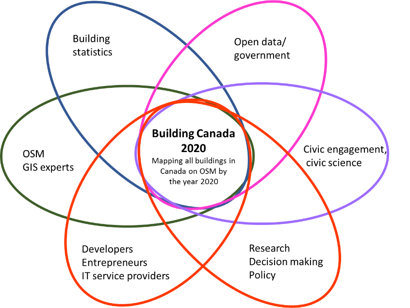
I’ll be participating in the Building Canada 2020 community-led initiative.The goal of this project is to map and digitize every building in Canada on OpenStreetMap by 2020. Creating a free publicly accessible, non-proprietary source of GIS information that stretches from coast to coast to coast.

There is an estimated 10-15 million buildings in Canada that need to be digitized in OpenStreetMap. Over 2 million Canadian buildings have already mapped!

Building Canada 2020

Alt text

Posted by Pieter Vander Vennet on 8 November 2017 in English. Last updated on 12 January 2019.

After some experimenting and help from the Belgian OSM Community, I figured out how to tweak the parameters for the routing engine and steer the navigation process. It seemed as if the technical documentation was missing, so lets write it here.

The parameter file: routing.xml

All parameters for the routing file are stored in a single XML.

You can find this XML on the OSMAnd github. Head over there, and download it. EDIT: By now, all the documentation has been included upstream. Everything you can read here, you an also find in the github routing.xml file. This diary entry can still serve as a gentle introduction.

This document should be placed in a place where OsmAnd will find it. As I chose ‘external storage’ to store my maps (settings -> general settings -> Data Storage Folder (under miscellaneous title), adding this custom routing is easy. Plug your phone in your computer and go to the path /sdcard/Android/data/net.osmand.plus/files. Copy routing.xml over.

Reading the parameter file

routing.xml is actually documented quite good! Read the docs there to get some general idea.

Adding an option to a profile

The parameters are split per profile. I edited the bicycle profile, as that is what I use most (also see my previous diary entry).

Over there, add a toggle, e.g., if you want to avoid sett surfaces:

    <parameter id="avoid_sett" name="Strongly prefer asphalt and paving stones" description="Tries to route around sett and cobblestone, ideal if riding with a cycling cart" type="boolean"/>

The id is the name you’ll use in if-statements, the name is what shows up in OSMAnd. Save the file as described above and restart OsmAnd. Start navigation to somewhere. If you click the settings (the cogwheel on the bottom when starting navigation), your new parameter should show up!

Tweaking weights

Routing considers three major aspects:

  • access
  • speed
  • priority

Each of those aspects has its own section in the xml; you can’t miss them.

Access

See full entry

Posted by Pieter Vander Vennet on 8 November 2017 in English. Last updated on 24 July 2018.

Hello everyone,

The 26th of september was an OSM-meetup in Bruges. The few guys which where there - and especially Joost, must have gotten some weird and extremely contagious disease, called ‘mapperitis’. It has been the start of a growing involvement in the mapping efforts of OSM.

Falling in love

Although I’ve been using OSM as my navigation of choice for years now (prob. 5), it’s only recently I’ve actively begun mapping. Altough my first mapping were the ski routes on holiday, that was a one-off - until now.

Using streetcomplete, I’ve been surveying the surfaces of Bruges, which contains - as you guessed it, a lot of sett (aka ‘neat cobblestone’). In the meantime, I’ve been spreading that contagous mappiritis around as well - until it reached someone of the Fietsersbond. One of them had recently seen the talk by Escada and was wondering if it would be possible to map all cycling routes, their surface area and width, to test if they meet the vademecum. “Yes, this is possible” was my answer of course!

I followed by a short showcase of OSM, overpass-turbo and how easy it was to enter all this info. Although he was impressed, he was a bit scared of how much work it seemed to be - and that it is an older and not so tech-savy person didn’t help either.

That was a week ago*. By now, the north of Bruges (the center) is surface-mapped, and around 50 cycleways are measured.

*(To be honest, it was two weeks. However, I was on holiday one week, so I couldn’t map)

Routing around sett

In the mean time, I was confronted with another problem. Quite often, I’m cycling around with a cycle cart. These things are slowed down tremendously by sett stones. So I wondered, wouldn’t it be possible to tweak the OSMAnd routing to avoid those nasty cobblestones?

After a few inquirements on the community riot channel, it turned out to be possible. And not only possible, it was easy as well!

See full entry

Some of you will know that I recently conducted a survey of OSM user demographics. The survey closed at the end of August. Since then I have been collating and cleaning the data ready for analysis. The survey generated a fantastic response and I would like to extend my thanks to everyone who took the time to participate.

As promised, sixty respondents have been randomly selected to receive a £15 Amazon voucher as a small gesture of gratitude for participating. I have now sent the voucher codes out via the OSM messaging system so please check your in box to see if you are one of the lucky recipients.

I hope to be able to share some preliminary results in the coming weeks and look forward to seeing exactly what the data reveals about the impact of gender bias in OSM contributing.

Due to China strict law of map concerns of China, stuff including military area on OpenStreetMap is not welcomed by China mapping law. Some China Mappers are thinking about removing sensitive military area on OpenStreetMap. One of the mapper FreedSky is censoring map stuff on OpenStreetMap, and start removing military landuse on OpenStreetMap

I revert the changeset 53508675 and changeset 53508564. It’s the military area on Fujian, which is the standing opposite Taiwan.

In the previous experience deal with national security, military landuse in Israel and South Korean was removed by local mappers. But the the removed stuff was recovery when someone discovered and talk on the mailing list.

Which is important, the national security of certain country, or the global goal of mapping everything on the world?

Location: Dongguan, Yongchun County, Quanzhou, Fujian, China

Time : 11:16 AM (Bangladesh) Location: @my_students_home Mapping Location :#1075 - Bamako (Mali)

Hi diary, I am bored sitting and doing nothing !!! My student is giving exam so I thought of using this idle time to map @osm. I feel to contribute from beginners level and this mapping location seems fun. Good luck to me and to my student for her quiz !! ;)

Best Regards, Akhi Agatha Jetra