Diary Entries in English

Recent diary entries

Multiuser mode

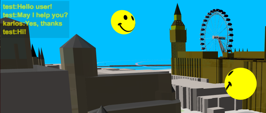
Now, you may go into the OSM-Data world and visit places ‘together with a friend’. As you move around, you will see your company next to you, also moving and watching. If you just start “OSM go”, your user name will be the name of your country. Or call www.osmgo.org?user=myName. Use a nickname or even better, use your OSM-name. A 2nd-click any place you want to visit and select the icon of “OSM go” to enter. Your friend may follwow you, using the slippy map (see below).
multiuser

There is a ‘chat’ implemented in “OSM go”! Press key C and enter text in the popup dialog. The actual chat texts will be shown in the text box at the top left. There you will also see if an other user is dropping in or leaving. If you like to test it with me (-karlos-) just send me a time, I may be there and guide you. So don’t be afraid if you use “OSM go” and see a moving smile. Some visitors and me had already a lot of fun doing this. Some user of “OSM go” may have been shocking surprised, sorry.

See full entry

Posted by smaprs on 30 May 2017 in English. Last updated on 14 June 2017.

Hi, I share here a 3D digital elevation model of Mount Everest I’ve made, showing the main climbing routes and localities, with Landsat image backgound.

See and browse it at:
https://smaprs.github.io/Everest-3D/

Hope you enjoy it. 3D digital elevation model of Mount Everest

Made in QGIS using:
-Nasa Shuttle Radar data SRTMGL1 GeoTiff image for contour lines and 3D relief model, obtained from https://gdex.cr.usgs.gov/gdex/ (osm.wiki/SRTM#Official_versions);
-Background Image LANDSAT 4 Geo Tiff LC81400412016324LGN00.tif Date:2016/11/19. Courtesy of the NASA EOSDIS Land Processes Distributed Active Archive Center (LP DAAC), USGS/Earth Resources Observation and Science (EROS) Center, Sioux Falls, South Dakota. Online resource: USGS Global Visualization Viewer - http://glovis.usgs.gov/
-Contour lines made with Raster plugin from GdalTools;
-Qgis2threejs (https://github.com/minorua/Qgis2threejs), very frienldy to use (just confirm project CRS is set to EPSG:3857);
-Map data (location points and lines) from OpenStreetMap.

See full entry

Location: Tashi Dzom, Tingri County, Shigatse Prefecture, Tibet, 858200, China
Posted by GOwin on 30 May 2017 in English. Last updated on 2 June 2017.

Keeping up-to-date, relevant maps, is a challenge for many organizations, especially if they don’t have the in-house capacity, or the resources to systematically maintain geo-spatial datasets that are useful across multiple departments or end-users. This is not an uncommon scenario in many municipal governments in the Philippines.

Over the last several months, the MapAm❤re Initiative in San Juan, have been collaborating with local actors and promoting Free software, especially OpenStreetMap, to communities who are seeking to make the most of what’s possible with Open data.

Last Monday, we’ve successfully concluded a City Mapa-thon for DRR to help the local government, in particular the City Disaster Risk Reduction Management Office in creating and updating the map features necessary for their risk reduction and resiliency programs.

87% of the people who registered for the mapa-thon made it to event. Thank you to everyone who chose to spend their Monday afternoon with us, helping out the city of San Juan.

Thank you, too to the City DRRMO, for hosting the event and making their facilities available for the volunteers.

A big thank you to our generous benefactors who sponsored the pizza and drinks. And a shout-out to Mapillary, for the swags we raffled after the mapa-thon. Maraming salamat!

See full entry

Location: Corazon de Jesus, 1st District, San Juan, Eastern Manila District, Metro Manila, Philippines
Posted by SomeoneElse on 29 May 2017 in English.

I’ve created a map legend for the map style that I use. It’s a set of map data that can be appended to a rendering database to create a map legend in a blank bit of map (actually in the middle of Australia).

There are currently two parts - linear features and POIs. As far as the map is concerned these are “real POIs” (though they’re never added to OSM itself of course - just added to the rendering database) so you need to zoom in to see some of the POIs such as the one for vending machines, which only appears in this map style from zoom level 19. You could use it with other map styles, but some of the features are dependent on this lua script.

Here’s a preview of what the “roads” part of the legend looks like:

roads

but to use it properly follow the link and move around.

Posted by alexkemp on 29 May 2017 in English. Last updated on 2 July 2022.

Don’t misunderstand me; I like civilisation, I really do. I like that my grand-daughter Micaela can walk down the street without needing to actively fear every man that walks past, or worry about being pounced on by a sabre-toothed tiger, or a cave-lion. There are just so many benefits, like amoeba-free water plumbed direct into the home, lots of shops with shelves full of food good to eat, and maps of the area freely available. It’s all excellent stuff, even if it’s just the Matrix.

So why do I miss wild woods? With wolves, and deer running free? Possibly it is the Austrian blood from my mother calling to me, or perhaps because I have finally reached the edge of Nottingham’s suburban housing (Spring Lane), but at my last mapping session I was able to stand within Gedling Country Park and gaze from the high sierra south across a vista of naturally-seeded trees (please forgive my whimsy) and gain a hint of what the long-gone Sherwood Forest might have looked like:–

lambs ready for the slaughter

See full entry

Location: Gedling, Carlton, Gedling, Nottinghamshire, East Midlands, England, NG4 4BH, United Kingdom

Last week on the margins of the Turkmenistan Gas Congress held in Awaza I did some update mapping of the the Awaza resort zone, with extensive use of Mapillary to capture imagery. Since the zone is now off-limits to private automobiles it was a rare opportunity to capture bus stops, new hotels and facilities, and generally to upgrade the map. I also added several names of streets in downtown Turkmenbashy and edited the existing street names extensively to bring them into conformance with what is actually on street signs. Russian main name entries are now name:ru=* entries. I added two cemeteries, some street addresses, and edited a couple of streets based on GPS traces. The new expanded seaport, under construction by Gap Inşaat and due to be completed next year, has changed the coastline so I need to review recent satellite imagery and update that as well.

This weekend I added POIs to the new village of Bereketli Zaman, including the fire station and mosque, then added interpolation=* ways so the village should now be largely navigable by house number. It is a strictly cookie-cutter layout so deviation of the mapped house numbers from reality should be minimal.

Location: Awaza, Türkmenbaşy, Balkan Region, Turkmenistan

OpenStreetMap allows people to add notes to the map, people can comment and mark a problem as resolved. This is an easy way for mappers to talk to each other (“Is this mapped right?” “Yes I was there the other month, the aerial imgaery is old” “OK So”), and is an easy way for non-OSM people to provide simple feedback without needing to log in, and (importantly) not break the map if they don’t know what they are doing. Experienced mappers can use them to highlight areas or issues they think should be addressed.

There are now more than 1,000,000 notes in OSM. There was some discussion on the OSM main mailing list about this. Some people don’t like how easy it is for some apps (Maps.me) to add notes, and complain about the amount of useless notes. Yes, a high signal to noise ratio can make things hard. However OSM is open and a wiki map. There shouldn’t be barriers and gatekeepers. If you want only “approved” people to be able to add data to your map, go play with Google Map Maker.

The concern about signal to noise ratios is valid. There are a lot of notes now. About 250,000 open notes. (check on pascal neis’ notes page).

So I’m going to make an effort to look at notes and try to fix up problems. Some cannot be solved from the armchair, but there are lots of new users leaving notes that can be closed, or which describe things which have since been mapped. And some are things you could map. I’m going to work my way through some of the notes in Ireland.

If we all take a few minutes each day to look at notes that people are submitting, we’ll keep the map updated and fixed up.

Resuming from previous diary posts, we would like to start off with interesting changesets we have observed over the last month. Nearly all of these changesets have been flagged by currently existing filters in OSMCha.

Here is what we found

image We found randomly added parks in the form of letters K N N in this changeset. This was detected while we were reviewing changesets from pokemon nest by new user filter in OSMCha.

See full entry

I have a program ,and want to make a map to show my staff’s route. I copyed codes from the website of osm.wiki/OpenLayers_Simple_Example , but these codes doesn’t work . I ask for help ,which online file can I read to solve my problem or can you give me some example? Thanks for your help.

Location: 岩大房社区, Hangzhou City, Zhejiang, 310053, China

I stumbled upon OpenStreetMap (OSM) recently. At first I was overwhelmed to see the amount of community work that is put together and reflects in the maps that are created. I was also excited to know how a hobby project of a person now resonates into something that has become a huge success. I started off my OSM project by mapping my hometown Kolar Gold Fields.

Kolar Gold Fields often acronymed as KGF is a small town located in Karnataka, It was once famous for the gold mining which eventually stopped in the year 2001 due to receding deposits. KGF is often compared to England due to its climate and the beautiful landscapes. hence known as “The Little England “

mine final


See full entry

Posted by muramototomoya on 25 May 2017 in English. Last updated on 29 June 2017.

Event

Other

Event

Software

Other

Posted by alexkemp on 24 May 2017 in English. Last updated on 29 May 2017.

Please remove these Profile spammers (from Other nearby users, as shown in my Profile page).

Info on Profile Spammers

If you have access to their email address & IP you can signup at SFS & report them on to the DB, which will then prevent them from spamming any other forum/blog that makes use of SFS.

felineescorts (removed - thank you) (spam for escorts):–
Signed up:– 10 April, 2017
Edits:– 0
Traces:– 0
Diary:– 0

bohemiagirkl (removed - thank you) (spam for escorts):–
Signed up:– 13 March, 2014
Edits:– 0
Traces:– 0
Diary:– 0

debbie bryan (spam for a shop; no link, but is still spamming):–
Signed up:– 25 March, 2009
Edits:– 0
Traces:– 0
Diary:– 0

Steveford11 (removed - thank you) (pharmaceutical spam):–
Signed up:– 11 April, 2014
Edits:– 0
Traces:– 0
Diary:– 0

RDArchitects (spam for architects practice; no link, but is still spamming):–
Signed up:– 12 October, 2012
Edits:– 0
Traces:– 0
Diary:– 0

This is 5 of 30 users, suggesting that 16.7% (1 in every 6) of users sign up purely for the purpose of spamming OSM. After an analysis of those 30 users shown on my Profile, I found that 80% made no or very little contribution (3 or less edits) to OSM; this seems to be the classic 20%/80% split, and makes it very difficult to understand why all these redundant users should be retained.

Posted by n42k on 22 May 2017 in English.

Hi! I’m Pedro Amaro, an undergraduate student from Portugal. Currently, I’m studying Informatics and Computing Engineering at FEUP (Faculty of Engineering of the University of Porto). I will be working on a project for the OSM community for Google Summer of Code 2017. I took a special interest in OSM for my GSoC proposal, as I had used it before multiple times, mostly to know my bearings and also in the FlightGear flight simulator.

One of the most interesting suggested projects, that mixed some of my interests, including 3D graphics and web applications, was the implementation of a 3D Model Repository. This project consists of implementing a repository for 3D models, where users can upload freely licensed models and their metadata to it, so that 3D visualizers can use this data to render beautiful graphics for buildings (such as the Eiffel Tower) or smaller features such as trees. After a lot of back and forth with the project proposal with Tordanik, I submitted it, and around a month later, was accepted.

In my proposal, I had suggested using OpenLayers as the API for drawing maps in the repository, and having the live 3D preview of models be optional. Upon further discussion, we decided to change the API to Leaflet and start working on the preview early in the summer, by June.

To explore both ideas, I built a small demonstration of each, to get acquainted with the tools I will be using, namely Leaflet and Three.js.

See full entry

Posted by Math1985 on 22 May 2017 in English.

Today, v3.3.1 of the openstreetmap-carto stylesheet (the default stylesheet on openstreetmap.org) has been released.

This version includes a single change: * Fix a regression in intermittent waterways

For a full list of commits, see https://github.com/gravitystorm/openstreetmap-carto/compare/v3.3.0…v3.3.1

As always, we welcome any bug reports at https://github.com/gravitystorm/openstreetmap-carto/issues.

Last weekend, I tried modelling San Francisco City Hall in S3DB. The public building has 100 years of glorious history. The diameter of the central dome is around 34 m and total height of the building is 93 m. From Wikipedia

The co-ordinates of the building is 37.77910°N/122.41937°W. Edited this model first through OSM Sandbox and copied all the geometries and tags to main OSM database. I used JOSM current version and Kendzi3D plugin to visualise locally.

Before Simple 3D tags

See full entry