Diary Entries in English

Recent diary entries

Posted by sabas88 on 1 March 2017 in English. Last updated on 11 March 2017.

Wikidata, as a project derived from Wikipedia, could be viewed as a crowdsourced database of VGI (Volunteered Geographical Information), of course less structured than OpenStreetMap spatially but at least comparable: we think that a cross-reference could be worthwhile for both projects. This work has already started from some years ago with the wikipedia tag (notably the WIWOSM project, and in Italy wtosm) but now the focus seems to be moving towards the use of Wikidata instead of Wikipedia.

In this post I would like to introduce our experiment in this direction, powered by the resources we have as a chapter of both the OSMF and the WMF.

We started from an existing OSM database replicated every half hour through osmosis, where all the tags are dumped in an hstore column and we added a table called wikidata and a view which gathers existing elements tagged with the wikidata key (UNION of nodes, ways and relations).

The wikidata table is populated by a script which parses the weekly Wikidata dump (~10 GB gzipped line delimited json): we get only the elements having a claim with the P625 property (an element with at least a coordinate) and we take only the ones in Italy (a “rough” point in polygon test). The objects are then saved with the most precise coordinate available, their id and a label (italian, english, serbo-croatian or the first available).

Why serbo-croatian you may ask? We noticed that the Wikipedia editors created a lot of stubs from Geonames which went to generate new Wikidata items having only the label in the sh iso code :-)

See full entry

Posted by GMHeyes on 1 March 2017 in English.

The area I now live in is a bit short of detail, I enjoyed editing around my previous address, so last night I thought I would start adding features around my new home. the aim is to start locally and then moving around my home town! I made half a dozen or so edits, which included shops, a path, removed a road that no longer exists, grassed areas and terraced housing. None of the above is yet to appear on the map, I have checked on my iPad, PC and mobile phone. I used the id (In browser editor)

Location: Top O' Th' Meadows, Saddleworth, Scouthead, Oldham, Greater Manchester, England, OL4 3SG, United Kingdom
Posted by mtc on 28 February 2017 in English.

Doing some mapping during a week-long vacation. Really fun indeed. Great way to explore a place that I have never seen before. At first glance, the area looks complete already, but it is all imported data, so there is a lot to check and fix.

Today, I was asking a very old lady - who was walking with her two unleashed cats in her front yard - where was the lighthouse that I was verifying. She looked surprised, but gave me quite clear directions. As it turns out, the tiny lighthouse had been converted into a residence, and it was no longer being used as a navigational aid. The neighboring houses are just as large, and they made the already squat structure look comically small. I had a good chuckle, on seeing this unusual neighborhood.

Location: Hyannis, Barnstable, Barnstable County, Massachusetts, United States

I like mapping by going out in the field, especially in the forest. Finding new (for me) trails and roads is very fun.

For mapping in Sweden I often use an old (expired copyright) map called Ekonomiska Kartan, by adding is as a tile layer in JOSM. It has names for farms, hamlets, mountains, forests, lakes and so on, which is often hard to come by otherwise. However, since it is old many things have changed on this map. I use this map together with Mapbox satellite images in JOSM, which is more recent.

Sometimes it is hard to determine if an old road, or similar, still exists, bu purely looking at Ekonomiska Kartan and Mapbox satellite. Recently I made a tile layer (just for the area where I live) that consists of DEM from SRTM, together with slope data from the Swedish forestry administration (Skogsstyrelsen). While this data is “open data”, it has a license that is incompatible (I think) with OSM. So I just use this tile layer to figure out where to go with my GPS to map in the field.

See full entry

Location: Grindstugan, Nyköpings kommun, Södermanland County, 618 95, Sweden

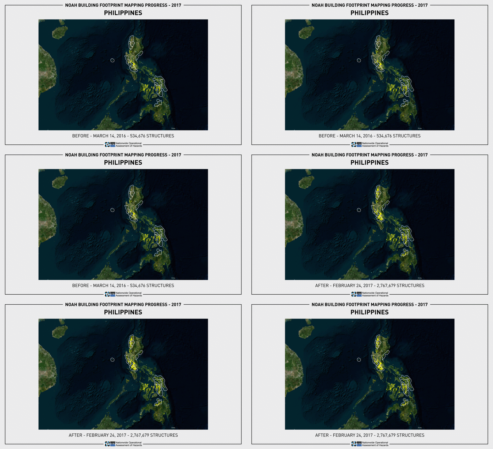
Project NOAH has finished mapping the building footprints of ISAIAH’s 15 target provinces and an additional province for “good will”. The completion of its mapping initiative was made possible through the help of several organizations and individuals such as MAVC program, Aurora Provincial Disaster Risk Reduction and Management Office, UP Rockhounds, Geographic Society of the University of the Philippines (GSUP), Eastern Samar State University, Eastern Visayas State University, UP NSTP-CWTS program, and OSM-Philippines contributors. NOAH finished mapping the building exposure data of Abra, Aurora, Bataan, Batangas, Biliran, Camiguin, Cavite, Eastern Samar, Ilocos Norte, Ilocos Sur, Leyte, Misamis Oriental, Northern Samar, Samar, Southern Leyte, and Zambales. NOAH also mapped the building footprints of Pateros and Taguig City of Metro Manila.

Philippines Before and After Edits NOAH

See full entry

Wir haben gerade v5.6 der Open Source Routing Machine (OSRM) veröffentlicht. Wie gewohnt mit Dokumentation, NodeJs Bindings und einem osrm/osrm-backend:v5.6.0 Docker Image. Mehr Details gibt es hier. Sieht auch die Release Notes und den kompletten Changelog.

Was ich in diesem Beitrag vorheben möchte ist das Hauptfeature des 5.6 Releases: Die Trennung von Geschwindigkeiten und Kantengewichten

Bis zum 5.6 Release konnten Nutzer nur die Geschwindigkeiten per Lua Profile anpassen and diese basierend auf Tags und Präferenzen verändern. Die Routenplanung hat dann den schnellsten Weg gefunden und dabei die Zeit minimiert.

Allerdings gibt es klare Fälle in denen Nutzer bestimmte Strassen vermeiden möchten: schmale Gassen und Passagen über die normalerweise nicht gerouted werden sollte. Bisher konnten Nutzer diese Wege entweder komplett aus dem Strassennetz entfernen oder aber die Geschwindigkeiten künstlich herabsetzen. Die Geschwindigkeiten zu modifizieren hat jedoch einen gravierenden Nachteil: wenn die Routenplanung nun doch über eine solche Strasse führt sind die Ankunftszeiten falsch!

Was wir stattdessen benötigen ist eine Trennung von Geschwindigkeiten (und damit Reisezeiten welche die Routenplanung aggregiert) und Kantengewichte auf denen die Routenplanung optimiert. Mit dem 5.6 Release haben wir diese grundlegende Trennung!

In den Profilen können Nutzer nun:

  • Die Geschwindigkeiten weiterhin basierend auf Tags setzen um realistische Ankunftszeiten zu erhalten und
  • Spezielle Strassen vermeiden indem Kantengewichte unabhängig zu den Geschwindigkeiten verwendet werden.

Zusätzlich erlaubt uns die Trennung von Geschwindigkeiten und Kantengewichten die Handhabung von access=destination und ähnlichen Tags, die es erlauben die Strasse nur zu verwenden wenn sich das Ziel dort befindet. Ein typisches Beispiel sind Gated Communities durch die Nutzer nicht gerouted werden möchten, ausser sie wollen explizit ihre Reise dort enden.

See full entry

Location: 52.521, 13.410

We’ve just released version 5.6 of our beloved Open Source Routing Machine (OSRM). The release comes with documentation, NodeJs bindings and a osrm/osrm-backend:v5.6.0 Docker image for an easy setup. More details here. See the Release Notes and the Full Changelog for more details.

What I want to highlight in this post is the 5.6 release’s main feature: Making Travel Time and Edge Weights Independent

Up until the 5.6 release users were able to adjust way speeds based on tags and their preferences via user-provided Lua scripts. The routing engine then did fastest path routing minimizing for duration.

Now there are use-cases for which you want to penalize certain ways: think alleys or small roads which you don’t want the routing engine to prefer. Before the 5.6 release all you could do was to either discard those ways completely or adjust their speeds and make them artificially slower. Adjusting speeds sounds like the way to go, but if the routing engine then really needs to route you over such a way your ETAs will be off by the adjusted amount.

What we instead need is a split between travel time the routing engine aggregates along the way and edge weights the routing engine minimizes. With 5.6 we finally made that major architectural switch.

In your profiles you can do both now:

  • Fine-tune way speeds based on tags to make for great and realistic ETAs and
  • Penalize ways by setting edge weights independently of speeds.

In addition we can handle restricted ways now, too. By restricted ways I mean access=destination and similar which you are only allowed to travel on if you are going to this area. A typical example are gated communities which you don’t want to get routed through except you explicitly want to go there.

See full entry

Location: Mitte, Berlin, Germany
Posted by alexkemp on 27 February 2017 in English. Last updated on 7 July 2022.

At the end of my most recent mapping session in Gedling, Nottingham I mapped Albert Street & Victoria Street. It was only right at the very end that I got the point (Victoria & Albert: geddit?). It is immediately obvious from the state of it’s road that Victoria Street is unadopted (a private road), but I was surprised to discover that the end of Albert Street is also unadopted. My goodness, but it is confusing…

This photo shows not just the state of Victoria Street (it is the road in the foreground) but also the locked-gate that lorry drivers keep trying to use to cut through from Westdale Lane East (at the end of the service road) to Main Road (well behind the camera) (I’ve done my damnedest to make sure that that does not happen with OSM):–

Albert Street gate

See full entry

Location: Gedling, Carlton, Gedling, Nottinghamshire, East Midlands, England, NG4 4BH, United Kingdom
Posted by Ogmios on 26 February 2017 in English.

The German OpenStreetMap-Blog Wochennotiz № 343 mentioned an article in the German OSM-Forum about glass recycling containers. It criticises the use of the more general recycling:glass=yes instead of recycling:glass_bottles=yes.

While checking the tagging of containers in my region I found plenty other errors. Many containers in Germany have names describing their purpose and other problems.

Names instead of proper tags

In many cases recycling containers aren’t tagged properly (e.g. recycling:glass_bottles=yes or recycling:paper=yes tags are missing) but with names describing their purpose. Very often they also have a name tag with an address or description of their location.

While names containing a description of their purpose are easily translated into proper tags, others are not. With names containing a description of their objects’ location it is difficult to decide if it is a reference given by their operator (which should be tagged as reference), a helpful description (which should be tagged as a description) or redundant description of their location.

One can find recycling containers having a name tag using an Overpass Query:

node({{bbox}})
  [name]
  [amenity=recycling]
  [recycling_type!~centre];
out meta;

Excessive use of recycling:*=no

Some recycling containers have plenty recycling:*=no tags. According to the Wiki anything not having an recycling:*=yes is implicitly recycling:*=no. In some rare cases the explicit use of recycling:*=no might be helpful but in most cases it seems excessive and unnessesary.

Overpass Query:

node({{bbox}})
  [amenity=recycling]
  [~"^recycling:"~"no"];

out meta;

Incomplete Tagging

Many recycling stations are insufficiantly tagged, missing recycling:* or recycling_type=[container|centre] tags.

See full entry

Posted by alexkemp on 26 February 2017 in English. Last updated on 7 July 2022.

I appear to be obsessed with broken-down garages. Here is one of the best examples so far, next to Priory Road,Gedling (otherwise, a very smart road):-

desolated garage

Update 7 July 2022

Mapillary has changed it’s download URLs & therefore all links within my diaries that used a Mapillary download URL in the old format are broken (the Mapilliary map URLs, which show a photo within the context of an OSM map, have also changed and are redirected via a HTTP/1.1 302 Found, but the download URL hostname no longer exists and gives a “No address associated with hostname” DNS error). I’m slowly going through to update them. The new URLs are terrifyingly long, but show OK on my screen (and I hope also on yours).

Location: Gedling, Carlton, Gedling, Nottinghamshire, East Midlands, England, NG4 4BH, United Kingdom

In which I explain the differences between the exit_to= tag on the highway=motorway_junction node and the more recent destination= tag on the way branching off of the motorway. In addition I will show the need for handling both tags and leave you with a tool for automatic rewriting.

To provide great guidance for our Open Source Routing Machine users we want to include ramp information for highway navigation.

There are two established tagging schemes for highway ramp signage:

  • Using the exit_to= tag on the highway=motorway_junction node where the ramp branches off of the motorway. This tagging scheme was established mainly because the default Mapnik style displayed the tag quite nicely.
  • The more recent destination= tag on the way branching off of the motorway.

Why do we have two completely different tagging schemes? Have a look at the following example where a ramp branches off the continuing motorway:

a . . . b . . d .
          ` . c .

In this case the exit_to tag is placed on the node b together with the highway=motorway_junction tag. So far so good. Now consider the common situation where multiple numbered exits diverge at a single point.

            . c
a . . . b `
          ` . d

Now there are destination signs for the ways bc and in addition for bd. There are workarounds like exit_to:left and exit_to:right tags but as you can imagine these do not suffice for more complex situations.

For these situations the destination tag is the better alternative.

Here in an example for where we need such a workaround.

See full entry

Posted by Thomas Starnes on 25 February 2017 in English. Last updated on 26 February 2017.

Geographers - expeditions need you!

It was some time in October 2016, and my friend James asked me if I was up for an adventure. Without hesitating, I agreed. We had met at the Royal Geographical Society, at the annual ‘Explore’ weekend several years ago. We had stayed in touch, become good friends, and the previous year I had joined an expedition that he had led to Madagascar. There we studied the forest ‘edge effect’ i.e. the effect of proximity to forest edges, on amphibians and reptiles. On that expedition I had been appointed GIS and Data Specialist - a role not dissimilar to my then-day job with Amphibian and Reptile Conservation in the UK. I think it was somewhat to James’ surprise when it turned out that I knew relatively little about herpetofauna, but my saving grace was that I did know about GIS. Evidently I had proved my worth because now - one year later - James was inviting me on another expedition. This time it was botanical. This time it was Oman. I had just enough leave left to take the three weeks that I needed to go. I began furiously downloading data and preparing maps for the next adventure…

How do you use GIS to prepare for an expedition?

See full entry

Location: al Kahil, Al Jazir Province, Al Wusta Governorate, Oman
Posted by KenK425 on 25 February 2017 in English.

Note to self: Amber’s Birthday today. Today she is 40 years old (1977). OMG, 40?

First sunny day in a while. Temp: Low 30s, highs: l Low to mid 40s. Taking the bike out for a 200 mile trip to…. Don’t even know if I’m going North or South. I’ll fill you in when I’m back

Location: West Lake Stevens, Lake Stevens, Snohomish County, Washington, 98258, United States
Posted by mvexel on 24 February 2017 in English.

When using ImproveOSM, the Telenav tool to find and add missing roads (and other missing things) in OSM, sometimes there is just no detailed aerial imagery to see exactly what road type it is.

example

While you could say, ‘Well without being able to see, I won’t add anything’. But because ImproveOSM uses actual GPS traces from drivers, you know that people have been driving there. From the image in the example you can see that a fair number of people must have taken this route, so there must be some sort of road there.

So what I suggest is to add the road as simply highway=road (generic road tag). Then you or someone else can improve it later, based on better imagery or local knowledge.

The example in the image is this new way.

Remember that you can select multiple tiles on ImproveOSM by holding Shift while selecting. That way you can more quickly mark multiple tiles as Solved.

See full entry

Posted by Alex-7 on 24 February 2017 in English.

Last weekend I went to map an archaeological site. I had read a couple of academic archeological papers on this excavation and knew the exact location of the site.

It is a Roman tiles, bricks and ceramic workshop near the town of Chancy which worked for eight hundred years, from 1st century BC till 7th century AD.

This archaeological site was excavated, and then it was covered with earth again for preservation. Still there are antique tiles everywhere around. At that epoch it was a hi-tech enterprise, a place where the Roman Empire was actually built. And it is not completely clear why it was closed after eight centuries of production (an interesting question for today’s reality too).

As a result:

I convert video to the open WEBM format, which is accepted by Wikimedia, with the command line tool ffmpeg. Some quality is always lost in conversion, but so far it is the best variant:

ffmpeg -i source.mp4 -c:v libvpx -crf 4 -b:v 18M -c:a libvorbis destination.webm

See full entry

Location: 46.133, 5.967

For the curious, the crowdsourced open knowledge database - Wikidata has a property for OpenStreetMap tags that can be used to tag items that describe the same/similar object on the Wikidata database.

It took some time to understand how Wikidata items are described having been used to the more flat OSM tagging model, but we can use a simple example of the popular OSM tag of that is used for any human settlement as a start.

Finding a Wikidata item describing an OSM tag

Any notable topic that exists on Wikipedia will exist as a Wikidata item. Hence any widely used OSM tag should be easy to match to a Wikidata item. For example, cities are one of the most important features of maps, and from the OSM Wiki we know that this feature is described on the map using the Tag:place=city.

If we can find a Wikipedia page that describes the same concept as the OSM tag, we can get the associated Wikidata item from the sidebar links of the page. The Wikidata item for a city is Q515.

See full entry

As it says in the Subject line : have looked at a number of points raised near where I live, found one blocked street (Berkenlaan Antwerpen / Wilrijk) was not blocked , and no signs of roadworks or similar. Have added comment.

Question 1 : can I, as a novice contributor, declare the item as resolved, or are there trained and trusted resolvers, please?

Proceeded to the re-routed bicycle path / access road at the eastern end of the Antwerp/ Deurne airport runway, uploaded three tracks showing the connection road between a/ the decommissionned Fort 3 and the Beirenslaan, b/ the U-turn road with separate adjacent bicycle path, and c/ the bit connectin these two to allow traffic from the east to reach Fort 3 etc.

Question 2 : those tags : are these relevant as entered, which ones would experienced OSmappers have added, which ones would they have left out?

Next, visited recent parkland ‘Groot Schijn’ at the end of the Veldweg : found some concrete walking/ bicycling paths were not on the map, made tracks and will upload once initial comments received on first uploads.

Along Ruggeveldlaan one ‘doorsteek’ / U-turn passage doesn’t exist anymore ; track of new traffic light regulated pedestrian / cyclist crossing to be uploaded.

Further along Ruggeveldlaan : one building demolished (will add note on map), one access road moved.

Question 3 : how can upload the waypoint saved at the new entrance road, please? As a single point track?

Have taken photos w. Lumia smartphone, they’re on OneDrive, need to find out how to publish map with only photos pertaining to OpenStreetMap, excluding private ones.

Finallt visited end of Parkweg, where there is a query about section of road removed, which is correct : there’s a new parking area. Will add comment and/ or resolve once I know whether that’s up to me to do.

Looking forward to comments,