 OpenStreetMap

To an editor user for osm edits , I would definitely find nothing more comfortable that it. However, with my recent exposure to josm and all its abilities, life has been greatly simplified. It is embedded with a number of tools, more to it very simplified shortcuts to making viable edits, more to it is the minimal internet consumption hence a multi million edits can be performed in a blink of an eye. The ability of it being installed without cracks makes it much ore suitable. Thanks to josm because editing is now becoming an addiction.
Diary Entries in English
Recent diary entries
Posted by sinclarius on 22 February 2017 in English.
Last updated on 13 April 2017.

Found 127 incorrectly placed location points in downtown Santa Fe, NM (probably from a bulk GNIS import). Some are duplicates, some misspelled, some no longer extant. Recorded in note #901862 so that I can begin process of replacement/correction.
Posted by Haajee1934 on 22 February 2017 in English.

Parking lot and Buildings on road back of Hospital Buildings are not marked on Map This road joins to Kingsville-Ave on oneside and to Moross Road on the other side. Parking-lot on back is for Main Enterence of Building One. An office on back is where this Vehicle is Paked

We’ve got an OpenStreetMap London pub meet-up tonight!
We’re managing them approximately monthly these days, so last month we had a pub meet-up to kick off 2017. We went to the Wenlock Arms. It’s a nice little pub which almost got demolished but was saved after a campaign. Now with all the big new buildings around it reminds me of the very last scene of Batteries Not Included. But they have modernised a little. I remember their rather sparse pub website used to link to OpenStreetMap, but sadly their website was since rebuilt by some boring web designers with boring google maps.
I remember it used to be good for real_ale=yes, and that was certainly there still. Crazy strong stuff. Luckily I’d stuffed myself with fish n chips before arriving because food=no! But it does have real_fire=yes!

(Another photo for the real_fire=yes tag)

- Go to overpass link :- http://overpass-turbo.eu/s/mRF
- Click Export and take level0 editor [About 20mb]
- Browse and add each wikidata qid and upload wikidata = Q25203056
- QIDs of districts can be found in this link :- http://tinyurl.com/jbkfn6p
District Map in English Wikipedia:- here
District Map in Malayalam Wikipedia:- here

This month I came back to work on development of OSMCHA, a project that I started in the middle of 2015, with the aim of helping to detect potentially harmful OpenStreetMap edits.
My motivation to start OSMCHA was that I felt that we needed a better tool to monitor changes made to OSM data. Looking at statistics of how many nodes were created, modified and deleted in a day in Brazil, it was common to see some peaks in the number of created or deleted nodes. This made me curious to know - where are those changes… Has an import been made? What is the source of the data? Has someone deleted an entire town?
Furthermore, sometimes we discovered changesets that explicitly said that the data came from Google Maps or some other inappropriate source. Despite that information being expressed in the changeset metadata, it was common for those edits to remain in the OSM database for months or years without anybody seeing them.
As it is impossible for the community to review all edits, my idea was to create a tool to point the changesets that potentially can damage the map and to analyse the metadata searching for suspect words.
I showed OSMCHA for the first time in the SotM Latam 2015, in Santiago, Chile. The Mapbox data team became interested and started using it. Moreover, they developed some new features and now I’m very excited to announce that Mapbox is sponsoring my work in the next few months to improve OSMCHA.
In the last two weeks we enhanced documentation, lifted test coverage, cleaned up the code and prepared the code-base to receive the updates we are planning. The main move we are planning to OSMCHA is to rebuild the interface and make it map-based (instead of showing the changesets on a list, we want to exhibit it over a map). We have some ideas to make it easier for users to review the edits in their area of interest, have some notification features and improve the analysis of changesets, among others…
Posted by tasauf1980 on 20 February 2017 in English.

The new Year Showing the promise to become a year of recognition & opportunity I guess! Just been selected as a “Voting Member” of Humanitarian OpenStreetMap Team (HOT)!!!
Becoming more integral part of the HOT community is like a dream come true for me. I am sure the recognition will boost my moral and strengthen my voice to represent HOT in both local & global arena. This will motivate me more to dedicate myself to the cause & the community. I’m damn sure that there were many awesome HOT community members who might deserve to be in the team and their turn will also come in a very short period of time. It must have been very tough!!!
For me it was quite a surprise when Pete Masters informed me that he has nominated me as a candidate. I can remember I was asking him whether I’m ready for this and his answer was more than ready!!! I would like to take the opportunity to thank him and the others who have shown the faith on me and supported me throughout my short but eventful journey with #hotosm. I would also like to thank Ahasanul Hoque and the whole community of OSM in Bangladesh for their wonderful, illustrious efforts, commitments & achievements to the cause HOT is continuously working for. Each & every recognition I have & will achieve in this field will always be considered as the glory of your works & support. without you guys I’m just nobody!!!
I would like to congratulate all the new members in the panel who got selected. Thank you guys for your contribution and efforts that made you securing the seats.
Eagerly waiting for the formal introductions to new roles & to carry out the new responsibilities… :)
Posted by dikkeknodel on 20 February 2017 in English.
In August 2016 I was in the Portland, Oregon area for business reasons. I was however able to squeeze in some hiking time to enjoy the nice scenery that Oregon has to offer.
Among others, I found a hike along an abandoned stretch of the Port of Tillamook Bay Railroad online. The description sounded like a post-apocalyptic thing, so I was too curious to not do it. It was a great experience, and gave a good feeling of the forces at play to cause the destructions as seen there, which were 3 storms and the resulting water levels in the Salmonberry River.
However, when I later browsed the area on OSM I noticed that the Salmonberry River is not on the map at all. That could should not be the case, so I saw an oportunity to make my first big contribution to OSM.
Therefore I retraced my steps and combined it with info from USGS Topo maps to fill in the blanks and map the full river. Next to that I noticed that the Port of Tillamook Bay Railroad as imported from TIGER data, was not really accurate in position and none of the bridges and tunnels were put in. So I had work to do.
Five mugs of tea, one coffee, a skipped lunch, an emptied bag of Trail Mix and 13 edits later the whole river is mapped, the POTB railroad position has been corrected between Nahalem River and Wolf Creek Trestle, a few bridges have been put in and the Nehalem River has been slightly adapted. A bit more work to do, but I keep that for later! - A bunch of side branches that drain into the Salmonberry River - The tunnels of Port of Tillamook Bay Railroad - The Port of Tillamook Bay Railroad bridges east of Enright
I learned a lot about mapping and tagging today. I hope that will aid my future mappings and result in a short cycle time :).
Cheers!
Links: The hike @ Oregon Hikers
The Salmonberry River Link

Case in point: osm.org/node/1955249541
It’s a bakery set up by anarchists and it is self-managed. There are also examples of self-managed coops, for which I can’t find documentation on the wiki. It’s also worth debating whether it would be useful to differentiate between coops and more generally worked-owned establishments.
What are you views on it?
Posted by marczoutendijk on 19 February 2017 in English.
Last updated on 22 February 2017.

What shall we have for diner tonight?
### Improving the OSM map - why don’t we (14)
Some thoughts on restaurant and food-tagging on OSM.
A restaurant is considered an amenity and tagged with amenity=restaurant.
One would expect that in order to show what type of restaurant this is, or what food you can eat there, the next step would be:
restaurant=italian
restaurant=fish
restaurant=burger
After all, this is accepted:
natural=water
water=lake
But, alas, OSM is differently and so a new tagging was introduced to indicate what we can eat in a restaurant. No, they didn’t choose: food=* , but came up with:
cuisine=*
So, the correct tagging for a restaurant and what is served inside is:
amenity=restaurant
cuisine=italian
This is not so bad at all, because this scheme allows you to tag many more places where you can eat, but which are not considered a restaurant, like a cafe, bar or pub (or a railway station or book shop).
There are some curious constructions however, because to tag a Burger King (or any other fast food restaurant) you can do so in two ways:
amenity=restaurant
cuisine=burger
or:
amenity=fast_food
cuisine=burger
By itself, using fast_food as a value for an amenity is rather strange, because to me, fast food is a type of food, belonging to cuisine, not an amenity! (Would you use highway=asphalt? No, of course not, because highway=** expects a function of the highway it describes, not its surface).
The addition of the cuisine= in the last case is maybe not even necessary, as hamburgers are core business in any fast food restaurant.
Over the years the list of values to assign to the cuisine key has grown (and will keep to do so) and now (february 2017) we have two basic groups in the wiki:
- 40 values for the type of food (like fish, meat, pizza, burger, kebab, soup, etc.)
- 53 values for the ethnicity of the food (like italian, greek, chinese, mexican, etc.)

Keen to make it even easier to contribute to OSM, I threw a few pull requests at http://github.com/osmlabs/onosm.org - the github repository behind the wonderful OnOSM.org.
Its now possible for someone to use the ‘locate me’ control when adding their business; a small but important improvement for mobile users.
iandees has also been kind enough to clean up a few existing pull requests around internationalization - onosm.org now supports English, Portguese(Brazillian), and Italian. If you’d like to localize it, its really easy - just fork the github repository and create a new file in the locales directory.
There are a few other experiments for it pending, such as ‘sync my business details from a facebook page I own’, or ‘upload details of 5+ locations from a CSV’.
Ultimately, I’d be keen to provide an experience similar to a ‘manage my google listings’ scenario - both google and facebook have seen a lot of uptake from business owners. While business owners dont have quite the same incentive with OSM, I am really keen to make it as easy as possible if they choose to publish to OSM.
There are a few other ideas in the works, like “Invite a business owner to share/update their details”, or “check how my OSM listing appears on open data sites - maps.me, mapillary/openstreetcam, missing attributes, etc”
What do you see as the ultimate, simplest entry point to getting a business onto OSM with accurate, useful details?

I’ve been working on a JOSM script to expand abbreviated street names. There are hundreds (if not thousands) in the Plainfield, IL area.
This is extremely tedious work without so form of automation. So far I have reviewed every name change and it’s been working awesome.
I wrote up instructions at the GitHub link above. Give it a try yourself or let me know if you find an area with a lot of abbreviated names.

It gives me great pleasure to announce that the OpenStreetMap website now has a context menu! Also known as a right-click menu:
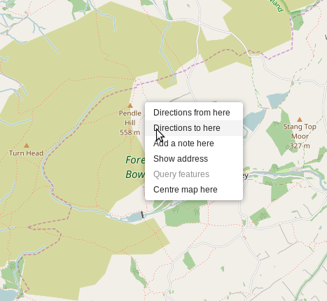
You might not think this is big news, but I do. A few people asked for this feature in the past, and eventually I proposed some code for it. It took 18 months for the proposal to be merged into the website codebase - why? Primarily because OSM is built and run by volunteers with limited time, but also because my Javascript skills weren’t quite up to adding the important polish and tests that are needed for production-ready code. A million thanks to Tom Hughes for improving my not-quite-finished proposal, and for all the feedback that helped me understand how to do things right.
Yesterday was a great day as I had chance to be a part of the mapping work shop held in Uganda Christian University Mbale, Uganda. We had a chance to be reminded of the good mapping practices and tips and also introduced to validation. it was a great excitement to us all learning how to validate and giving feedback to people who mapped the tasks. All thanks to Mr. Kateregga Geoffrey for the great work done.

Ireland:
http://taginfo.openstreetmap.ie/compare/amenity=pub/amenity=place_of_worship
pub: 3250 vs. place_of_worship: 3476
Hungary:
http://taginfo.openstreetmap.hu/compare/amenity=pub/amenity=place_of_worship
pub: 4858 vs. place_of_worship: 6372
Czech Republic
http://taginfo.openstreetmap.cz/compare/amenity=pub/amenity=place_of_worship
pub: 3963 vs. place_of_worship: 7625
Switzerland
http://taginfo.osm.ch/compare/amenity=pub/amenity=place_of_worship
pub: 686 vs. place_of_worship: 5259
Planet
https://taginfo.openstreetmap.org/compare/amenity=pub/amenity=place_of_worship
pub: 129298 vs. place_of_worship: 843735
I’ve just written to the UK and London mailing lists, suggesting a bulk edit to fix the outdated “network=Barclays Cycle Hire” in London. Harry proposed this 1 year ago.
Happy Cow is a website listing food places that vegetarians and vegans can use. The site has been going since 1999 and seems pretty well-established. I’ve proposed a tag for cross-referencing against Happy Cow.

As best as I can work out, the first photo that I took of All Hallows Church, Gedling was on September 19, 2016 from near the top of Chatsworth Avenue looking north north east:–

September 21 2016 saw me receive the chilling news about The Chancel Tax.
Throughout the rest of September & October I kept my head down & mapped to the West then North. By 23 November it was Arnold Lane outside Scot Grave Farm heading south-east and suddenly we caught a distant view of the church again:-


Stumbled upon this mistakenly dragged node thats been hanging around Sheffield for the last two months. Considering its not fixed despite having a highly active mapping community, wonder if some tooling could have helped flagged this to local mappers sooner.

Ideas on how to prevent such edits in future? Any existing QA tools that highlight this?