 OpenStreetMap

I am Bayazid Ahmed. I am from Bangladesh. I am studying at the Eastern University of Bangladesh. I am a joint secretary of our chapter, YouthMappers at Eastern University.
Diary Entries in English
Recent diary entries

A Step Forward in Mapping Together
Hello, OpenStreetMap Community!
We at Mapilio are thrilled to announce a significant update that’s been in the works for some time now — the integration of our imagery layers into OpenStreetMap, available through the iD editor. This collaboration represents a milestone in our ongoing commitment to enhancing the mapping experience for everyone in the OSM community.
 ## Why This Matters
The power of OpenStreetMap lies in its community and the collective effort to create the most detailed, open-source map of the world. By integrating our high-quality imagery layers from Mapilio, we aim to empower mappers with even more tools to enhance accuracy and detail in their mapping endeavors.
Collaboration at Its Best

♪♫ When Girls Just Want To Have Fun ♫♪
On March 23, 2024, as part of the Women’s Month celebration, the Viscan YouthMappers organization conducted a mapping activity titled “MapaBabae: When Girls Just Wanna Have Fun Mapping the Streets Using Mapillary.” This initiative aimed to pave the way for women’s empowerment through mapping, celebrate the contributions of women in the field of mapping, and inspire each other.

It started with an introduction of mine about what the Mapillary is all about which will be used by us by updating the streets of our University Campus that hasn’t been captured last mapillary event. Sharing that Mapillary is a collaborative street-level imagery platform wherein participants in MapaBabae are able to document their journeys and highlight points of interest, and share their stories regarding about this acivity. At its core, MapaBabae is about more than just mapping streets; it’s about creating a community where women feel seen, heard, and valued.
Posted by SeverinGeo on 28 March 2024 in English.

English below / Português abaixo
Il y a presque cinq ans, lors du SotM 2019 de Heidelberg, j’avais présenté une analyse critique du concept de mapathon sous le titre de « Mapathon Mapathon Mapathon ». L’historique du concept rappelait combien il s’agissait au début de projets menés sur plusieurs jours, pour devenir ensuite ce que j’ai appelé le mapathon 2.0, une action de cartographie collaborative sur imagerie dans une durée qui s’étend rarement au-delà de deux ou trois heures, avec des objectifs variables, au-delà de la donnée produite : promotion du projet OSM, engagement ou renforcement communautaire. communication sur un projet ou la structure organisatrice de l’événement…
Je ne pense pas que ce format 2.0 ait évolué depuis, mais il y a un aspect que j’avais identifié à l’époque sans pour autant le développer : le mapathon 2.0 en tant que forme privilégiée pour former de nouveaux contributeurs et contributrices OSM.
On pourrait penser qu’il ne s’agit pas d’une rupture avec le passé, mais plutôt d’une suite assez logique de la manière de former de nouvelles personnes à OSM avant l’avènement des smartphones, qui dans mon souvenir se sont démocratisés au Sud à partir de 2015 environ (voir ce graphique de l’International Telecommunication Union). Toute contribution dans OSM se faisait alors forcément en salle, vu que les moyens de collecte sur le terrain (terminaux GNSS classiques type Garmin Etrex ou cartes imprimées de type Walking Papers ou Field Papers) nécessitaient une reprise des données brutes du terrain sur ordinateur avec son éditeur préféré.

The Magdalen Islands (Îles-de-la-Madeleine) are an archipelago located in the center of the Gulf of Saint Lawrence (Eastern Canada). The heart of the archipelago is made up of seven rocky islands connected by long sand barriers, sand spits, dunes, and salt marshes. Including internal lagoons, the islands cover about 330 square km. The archipelago is sparsely populated and counts about 12K permanent inhabitants.
In June 2023, OSM describes the islands’ coastline, road network, some trails as well as some human and natural features. Overall, the islands were mapped using about 56K nodes, 5K ways, and 116 relations (Figure 1).
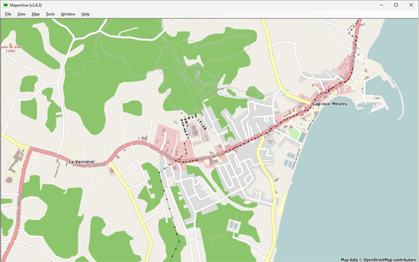 Figure 1: Cap-aux-Meules, before starting the project—Historical OSM data as of June 30, 2023, on Maperitive.
not been lazy but busy with so many other things, but got suddenly a new JOSM install fit for use an got catched for a few hours by now: I read some old wiki docs from 2008/09 i. e. the pilot work for Karlsruhe house number tagging schema in our town, added a few obviously missing objects, peeked into current issues nearby on Osmose did some corrections - all that feels good, this might even start a new series of contributions. :-)

[deleted]
What is this why is there a diary
Hi again,
It’s just 2 days before this diary post was published, and I’m very happy to announce that I will start proposing tags again. I already have exciting ideas and hopefully the community approves them.
EDIT: Next proposal will hopefully come tomorrow or this week, stay tuned!
Ewrt1
Posted by yvonnepaje on 24 March 2024 in English.

Shape my future with OSM Mapping and Youthmappers: Post Graduation Blog
A few months after my graduation, I find myself questioning how prepared I am to face the real world. Will the knowledge I acquired in school, particularly regarding organizational management, truly benefit me? Or could OSM mapping play a pivotal role in shaping my career path?
But how exactly do OSM mapping and YouthMappers influence career decisions?
Through mapping activities, I've gained critical thinking, problem-solving, and collaborative skills—qualities highly sought after in today's job market. Little did I anticipate that within these communities, I would uncover aspects of myself previously concealed. Leadership, once abstract, found a nurturing environment within the supportive ecosystem of YouthMappers. It was here that I discovered my capacity to lead, inspire, and effect change.
YouthMappers became my haven for personal development more than merely a platform. With every mapping project, my confidence increased. Although it was scary at first, public speaking became a skill I developed whenever I got the chance. Our community's response to our influence extended well beyond the boundaries of our maps, creating a lasting impression on people's emotions.
These days, certificates appear on my résumé as credentials as well as proof of my experience. They talk about the hours spent creating, learning, and working together. With the support of mentors and the friendship of other mappers, I learned things that went beyond what was found in textbooks.
Today, I stand not just as a graduate, but as a leader forged in the crucible of YouthMappers. I have the privilege to educate others on utilizing OSM mapping for change. Once reticent, my voice now brims with the fervor of someone who has experienced the potency of unity in action.

Welcome to my second OpenStreetMap NextGen development diary. I am ready to highlight this week’s progress — and there was a lot 👷!
You can subscribe to my diary updates on RSS here:
osm.org/user/NorthCrab/diary/rss
Finished Settings Page
Last week I showcased initial progress on the new settings page for OpenStreetMap. This week, I’ve finished it. Here’s what’s new. Keep in mind that if you believe some features should be done differently, there will be a period of public testing where I’ll collect this kind of feedback 😉.
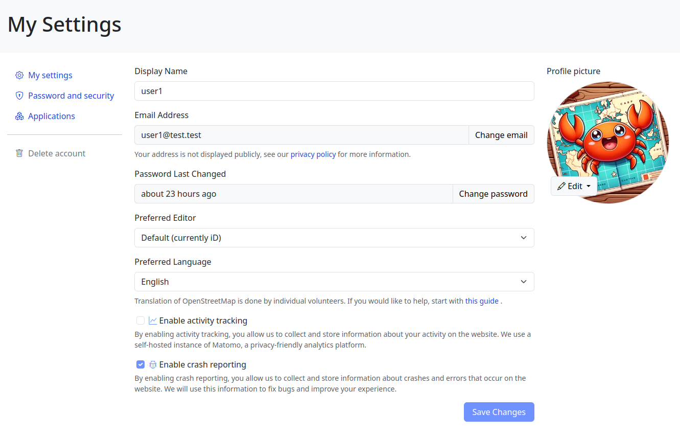
Click here to view it in full screen.
Aside from the improved layout, I’ve introduced two notable changes. First, the application language selection has been redesigned; it’s now a simple dropdown selector. I believe the current system (where you input locale names by hand) is difficult for less technical people to understand, and I want to make the website more accessible to everyone!

Participants shaded by umbrellas, to protect them from the sun, while collecting fresh geodata with FieldPapers. UP Mindanao Campus, Davao City. Photo shared by UPMinYouthMappers in their SNS post.
While visiting the family down south, I had a chance to join UP Mindanao’s own chapter, UPMin YouthMappers while their College (of Science & Maths) was celebrating Pi Day. The coordinator asked if I have any preference for the name of the activity we had in mind, and I suggested Map-Pi Day.

I’ve been kind of bouncing around various projects the past week.
I have tentatively completed sidewalk mapping in Emsworth Borough, and have moved on to adding sidewalks and pedestrian crossings in Avalon. I also did a little revamp of the playground adjacent to the Avalon Elementary School. It turns out that as I was extending the sidewalk along California Avenue, I met up with some previously mapped sidewalk bits, which is nice. Although they have not added a lot of the tags I do, so I will circle back to make this area a little more seamless with what I’ve added to the west.
I’m planning to go through Ben Avon and Emsworth to tag pedestrian crossings and curbs a little more consistently; I had been changing the way I tag things as I went based on new information/methodology.
I got kind of distracted when I realized that Pittsburgh Botanical Garden needed some updating due to their recent renovations. I was able to add the new visitor center and update a lot of the concrete paths, but I have some question marks as to the accuracy of some of the other paths on the property. I will take some good GPX tracks the next time I am there (likely this week). I especially want to see what progress has been made on the feature that is to the southwest of the Lotus Pond. I will also try to acquire a more precise/accurate/official property map from PBG, because the pictoral one on their website is great for ordinary wayfinding, but wholly inadequate in precisely showing where things are.
There’s lots of data stored in OSM about bus stops, but often maps and apps created with OSM data don’t make much use of it (with OsmAnd being the notable exception). For here’s a bus stop as shown by OSM Carto:
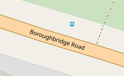
You can see that it’s a bus stop, and you’d be able to see the name if you could zoom in a bit more. However, in OSM there’s actually lots more information. For the map styles that I look after (both web-based raster maps and for Garmin devices) I tried to add a bit more detail. Here’s the result:
Today I decided to introduce a new format for sharing OpenStreetMap-NextGen development progress with the community. I’ll post weekly/bi-weekly updates highlighting changes and the current project status. Since this is the first update, I’ll cover some recent highlights.
You can subscribe to my diary updates on RSS: link.
New Settings Page (⭐ Highlight)
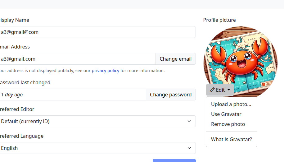
I’ve begun migrating the settings/preferences section. My goal is to streamline this experience, as I’ve found the current system a bit complex. Surprisingly, many users don’t know it’s possible to change the default editor — I want to make this more obvious.
A new menu on the left of the screenshot (hidden, not yet finished) will provide clear navigation between general, 2FA, OAuth, and other settings.
This page is still work in progress. I intend to add a help text explaining how to contribute to translations and that the translations are made by the community.

Eco Mappers OSM Rwanda ODD,
As we commemorated International Open Data Day and International Women’s Day, we embarked on a journey to intertwine these essential themes for equitable development. On Saturday, March 9, 2021, amidst a global celebration of Open Data Day, our event in Rwanda stood as a beacon of empowerment, bringing together over 50 enthusiastic participants eager to delve into the world of open data.

Before delving into the event’s highlights, it’s crucial to acknowledge the significance of Open Data Day. With more than 60 events worldwide, it underscores the global community’s commitment to promoting open data’s usage and accessibility. Thanks to the support from key funders, including the Open Knowledge Foundation, these events serve as catalysts for change, fostering collaboration and innovation.
Ahead of our event,

Last quarter, a “getting to know you” survey was made available to the local OpenStreetMap (OSM) communities in the Philippines, to help us better understand the current state of the active contributor base of our community.
The original idea was to run it just for the membership of local YouthMapper Chapters (YMC), but eventually it was made available to anyone who contributes to OSM in the Philippines, here or abroad, regardless of citizenship or affiliations.
I’m sharing my observations from the responses made by the participants who participated in the survey, again, majority of whom comprised of local YMC respondents.
Click on the images, to open them in full resolution in a separate tab.
Are you physically present in the Philippines?
While 86% of the mappers reported that they are physically in the country, mappers coming from elsewhere at 14% was bigger than I expected.

Which of the following best describe your primary undertaking in the OSM project?
Posted by Raquel Dezidério Souto on 16 March 2024 in English.
Last updated on 30 April 2024.

🍾 YouthMappers UFRJ celebrates its first year!
The YouthMappers UFRJ (Rio de Janeiro, Brasil) completed one year on March 14th, 2024.
And to celebrate this special date, we interviewed Dr. Rogério Luís R. Borba, analyst at the IBGE Foundation and manager of the Brazilian Geospatial Data Directory (“Diretório Brasileiro de Dados Geoespaciais, DBDG) of the Brazilian National Spatial Data Infrastructure (“Infraestrutura Nacional de Dados Geoespaciais”, INDE).
🎥 Watch on IVIDES.org’s YouTube channel.
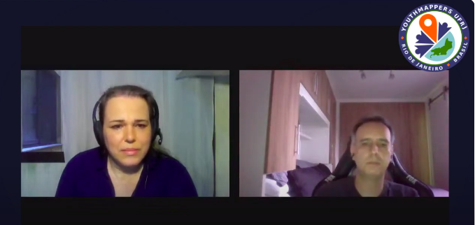
Rogério talked to us about the importance of open data and how the collaborative mapping can helps Brazil in the production of official cartographic data. The interview was conducted by Dr. Raquel Dezidério Souto and all details can be found at:
Happy Burger 11309 Midlothian Turnpike Richmond, VA 23235