Diary Entries in English

Recent diary entries

Posted by Tomas Straupis on 1 November 2023 in English.

Attack

In the sinister depths of a fellowship of the underground cartographers, known for its dark secrets, two veteran system administrators, Hat-trick and Springbok, had laboured tirelessly to maintain a cursed digital infrastructure for years. Their expertise was revered, their work likened to the dark heart of the company’s success.

On a moonless night, a group of overconfident, so-called dunkrugers challenged Hat-trick and Springbok. These individuals were unaware of the malevolent forces that dwelled within the servers, but their arrogance led them to believe they could control the sinister systems.

Ignoring the administrators’ chilling warnings, they recklessly invaded the server room, meddling with cables and initiating occult-like configurations. Their actions unleashed a torrent of unholy chaos as servers crashed, forbidden data was consumed, maps started to lie, and the very essence of the system unravelled.

See full entry

In May 2023, I discovered the existence of two websites : “The Skyscraper Center” and “Skyscraper Page”, presenting skyscrapers from all over the world and especially… skyscrapers from Pyongyang!

I took this opportunity to enrich several free projects on which I’m active: Wikidata with the creation of the elements in the first instance, combined with images from Wikimedia Commons in the second instance, to place them and link them with the OpenStreetMap data in the final instance!

Creating the skyscrapers in Wikidata

Wikidata is a database that can be very useful for the OSM project. In my case, it was very useful for tracking each skyscraper.

And it’s very well suited to adding all the skyscrapers that existed in The Skyscraper Center and Skyscraper Page for Pyongyang city.

Wikidata has a number of “properties” (PXXX) which can be used to provide a whole range of information:

  • where each building is located (P625)
  • when they were built (P571)
  • their height (P2048)
  • the number of floors (P1101), etc…

See full entry

Location: 39.023, 125.761

TLDR: No.

Very long version: Maybe

I was inspired by Feye Andal recent post, so I’m telling my experience and providing a workflow to those who face the same problem.

Background

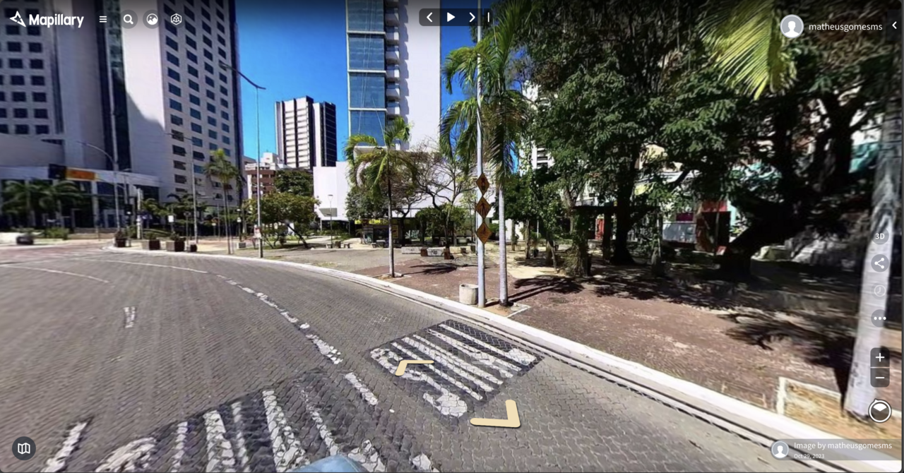
Recently I was looking to buy an affordable 360 camera to capture street-level imagery and obtain the processed elements that Mapillary provides (traffic signs and other points, via AI). I wanted it to use on my PhD research and of course, contribute to the OSM community and map data. The main recommendation is the now a bit old GoPro Max 360. The product is solid, and very easy to connect to Mapillary.

See full entry

Location: Sabiaguaba, Fortaleza, Ceará, Northeast Region, Brazil
Posted by Ride3400 on 31 October 2023 in English.

This is my first OSM contribution: THPRD in cooperation with Arbor Lakes HOA, LLC and Finley Woods/Noyes Development have created a new Waterhouse Trail segment with easement over Finley Woods and Arbor Lakes property. I added the new trail segment to the map after recording a GPX on my phone walking the trail. I hope I did it right!

Location: North Bethany, Bethany, Washington County, Oregon, 97229, United States

Personal notes about potential mapping of the Palenque archeological site from archeological GIS data.

Source

Edwin L. Barnhart. 2001. The Palenque Mapping Project, 1998 - 2000 Final Report

Questions

  • Permission to use the data, no licence specified -> get in touch with author
  • What to map in OSM? Only visitable areas? Major buildings (ie. Templo Escondido)? Waterways? All site (lots of buildings, does it belong to OSM)? A staged approach is necessary
  • Is there any local community / interest groups to get in touch with?
  • The data looks like it’s of good quality but dates from 2001. Any updated dataset?
  • 3D mapping of certain buildings?
  • Source for naming? Limited on-the-ground names, multiple naming schemes (the source paper claims to be overcoming this in a sensible way, is it still up to date, accepted by the archeology community?) English translation for certain objects
  • Any prior work in OSM for this site or similar archeological site?

Problems

  • Data in DWF format, how to import in JOSM

TODO

Location: Palenque, Chiapas, 29960, Mexico

Maplibre and Protomaps are a match made in heaven! Together they are democratizing vector maps! There’s no better time to get involved than now; let me set the scene first.

Maplibre SDK with Protomaps vector tiles, map at an angle with a video source playing drone footage video overlayed; data attribution (c) OpenStreetMaps and contributors

Maplibre is the open source map SDK forked from mapbox-gl-js when Mapbox changed their license and moved away from open source in 2020. Maplibre packages up around seven years of state of the art map renderer development and is best in class in terms of map rendering and styling vector tiles.

Protomaps is a relatively new project and it’s fundamentally changing how vector maps are distributed. Protomaps can package up the whole world into a single .pmtiles files of around 100 GB. Static hosting this single file gets us global vector tiles! Magic!

See full entry

Arquivos das apresentações realizadas no SotM Brasil 2023, que foram gentilmente disponibilizadas pelos(as) autores(as).

Para acessar as publicações (volume de anais e pôsteres,) clique aqui

Apresentações (por ordem alfabética)

AUTOMATIZAÇÃO DO PROCESSO DE IMPORTAÇÃO E CONFLAÇÃO MASSIVA NO OPENSTREETMAP

Matheus Gomes Correia, Kauê de Moraes Vestena, Gustavo Soares, Silvana Phillipi Camboim e Adelino Ferreira

See full entry

Location: Jardim Botânico, Curitiba, Paraná, South Region, Brazil
Posted by N@Mabuza on 28 October 2023 in English.

This diary is a collaboration between Ibrahim and Nombuso.

As part of the open humanitarian mapping community working group mentorship programme, all mentees were asked to produce a legacy project. As Nombuso wanted to work on data that would benefit women and girls in Eswatini and Ibrahim wanted to improve his technical skills, we decided to collaborate on one joint project.

Choosing eSwatini health data as the focus of our project.

We know that good quality health data is an asset for women and girls (to be able to find where there are services, when facilities are open and how far they might be away). So we decided to investigate how well OpenStreetMap provided information on these services for map users. First, we tried to download and consolidate all of the health data in OSM (amenity=hospital, clinic and doctors).

Map of Eswatini

See full entry

This diary is a collaboration between Ibrahim and Nombuso.

As part of the open humanitarian mapping community working group mentorship programme, all mentees were asked to produce a legacy project. As Nombuso wanted to work on data that would benefit women and girls in Eswatini and Ibrahim wanted to improve his technical skills, we decided to collaborate on one joint project.

Choosing eSwatini health data as the focus of our project.

We know that good quality health data is an asset for women and girls (to be able to find where there are services, when facilities are open and how far they might be away). So we decided to investigate how well OpenStreetMap provided information on these services for map users. First, we tried to download and consolidate all of the health data in OSM (amenity=hospital, clinic and doctors).

Map of Eswatini

See full entry

Open Geospatial Data for Disaster Recovery/Response

Fiji is a small island developing state and has been and continues to be severely affected by the obvious impacts of climate change, i.e. increase in sea level causing coastal erosion, water shortages due to salt water intrusion and the more apparent impact of the increased occurrence of extreme weather events such as tropical cyclones, storms, floods, droughts etc. Having personally experienced some of the worst tropical cyclones that has ever made landfall in Fiji, the project has been developed in light of the after effects of these extreme events. It takes time, resources and finance to begin rebuilding after a tropical cyclone hits and many are ill-prepared for this recovery process. For years, many Fijian communities have been all too aware of and much too dependent on the disaster relief packages they receive post disaster occurrence from the Fijian government, FRCS, NGOs and even international aids. However, it should be made known that there are alternative forms of assistance available for individuals, businesses etc. in regards to disaster relief/rehabilitation packages. The aim of this legacy project was to map and update points of interests entailing locations and relevant information relating to financial institutions/bodies that offer or have in the past offered disaster recovery/relief packages to members of Fijian communities within the Northern and Central divisions.

Area of study

Text

Data Collection

A survey was undertaken to gauge respondents various level of awareness of current, available disaster recovery/response packages in Fiji. In addition, certain financial institutions were also contacted via face to face office visits and through email. The financial institutions targeted are as follows; (i) Sugar Cane Grower’s Fund (ii) Tower Insurance (iii) Fiji National Provident Fund (iv) Home Finance Company Ltd

Results

See full entry

Posted by Davidien on 26 October 2023 in English. Last updated on 29 October 2023.

I made it an obligation to participate in this years edition of the SOTM Nigeria. I must say, it was worth it; because the various topics presented during this year’s conference opened up my mind to new possibilities in the world of GIS. I am also immensely grateful to the sponsors of this event for affording me the opportunity to be awarded a travel grant. Thank you SOTM Nigeria, see you in Lagos in 2024!

Location: Kuje, Federal Capital Territory, 903101, Nigeria
Posted by Ghostwalking on 25 October 2023 in English. Last updated on 26 October 2023.

Over the last few months, I’ve been filling out the houses and buildings in southwest London because I’m bored and have taken a strange fixation on improving the map in this way.

I have noted a few things over the last few months, particularly how the addresses to flats and rows of townhouses are managed. when marking out an area for a building of flats it only lets me put one address in, when flats typically have multiple addresses attached to the same physical building.

Not a major drawback at the moment but this is the main reason im not filling addresses in as there are typicaly more than one address attached to each building. Im not a coder here but this is my mild wednesday musing put on paper.

Posted by 38446 on 24 October 2023 in English.

Two years ago I somewhat naively asked on the wiki whether ÖPNVKarte couldn’t perhaps render the interval key somehow. I don’t think it would have to be as nicely designed as Transportparadise’s Oxford Bus Map, which even separates bus routes that share the same way. In my opinion, it would be sufficient to have the different patterns per way travelled (i.e. if two or more lines share the same way the pattern for the most frequent interval could be shown, or, more ambitiously, the intervals added up) for the map to give an overview of where public transport can take you more or less reliably. Unfortunately, I have lacked knowledge, experience and patience to use Maperitive and/or Overpass to try out how this could be put into practice and soon forgot about it.

The reason I came to think of this again was a holiday in Colmar, Alsace, France. To an outsider, the intervals of the city buses there are completely nuts, see for example this timetable pdf. But generalizing “37-48-41-51-44-etc.” into interval=45 would seem acceptable to me and a less fundamental question than how to discriminate between workdays and weekend. I am reflecting on this from a rural setting, where there might be no buses at all on Sundays.

Anyway, to a tourist, Colmar’s and Alsace’s public transport system is grand, amply subsidized and only partly affected by the typical downward spiral.

For our first hiking tour, we started from Wettolsheim Marbach through the vineyards first to the Les Trois Chateaux ruins and then on to the reconstructed Hohlandsbourg before heading back to the bus at Wintzenheim. The bus to Wettolsheim in the morning was in fact an on-demand service, a taxi ordered via the Flexitrace app and included in the normal fare: 1.50€ for a single trip, 11€ for 10 rides or 7€ for unlimited travel in 72 hours within Colmar and suburbs.

See full entry

Location: Colmar, Colmar-Ribeauvillé, Haut-Rhin, European Collectivity of Alsace, Grand Est, Metropolitan France, 68000, France

Reflecting on my experience at the SOTM Nigeria 2023 conference in Abuja, I can only describe it as an extraordinary blend of education and inspiration. The paper presentations were nothing short of eye-opening, shedding light on various facets of mapping, including cartography and geography. What made this experience truly enriching was the opportunity to interact and obtain ideas with distinguished professors, seasoned cartographers, accomplished geographers, and fellow mapping enthusiasts. Moreover, I had the privilege of contributing to the conference’s success by joining the volunteer team. I extend my heartfelt gratitude to Dr. Victor Sunday the coordinator of Unique Mappers for his organizing and chairing the conference, I sincerely appreciate the organizers, partners, sponsors, both for the conference in creating an amazing and enlightening event, and for the grant, as I await the promised refund to the entire volunteer team who came from Enugu State to Abuja for the conference, Obasanjo Space Centre, Municipal Area Council, Federal Capital Territory, Nigeria. #SotM2023 #HOTopensummit #TomTom #UMT #LionMappers #AfriGist #NASRDA #SciStarter #WNHub #MiyaAcademy #OSM #OSMNigeria