Diary Entries in English

Recent diary entries

Posted by b-unicycling on 23 October 2023 in English.

Some time ago, I started adding links to 3D models on Sketchfab to ogham stones, sheela-na-gigs and high crosses in Ireland. I thought that this was a good idea to add value to the map, because we already link 2D images, 3D is just so much cooler and more useful. Some of these artefacts are not accessible to the public at all times, and having a digital 3D model makes them accessible for all the world (with a fast enough internet connection). Of course, you could just browse Sketchfab, but having the geolocation can be interesting and useful too.

Sometimes, museums or universities have contracted someone to make 3D models of artefacts that might be in storage in a museum or inaccessible in a farmyard, thus providing OpenAccess to these models in digital form.

What started this initiative of was that I found a working photogrammetry app called Kiri Engine. Full disclosure now: They have made me an ambassador for their app, since I’ve been promoting it in a video already and have recommended it to a few friends in archaeology. But I would still promote it, even if they hadn’t done that.

I’ve made a video on how to use it (YouTube) which will be followed by another one soon. The previous video was about why and how to link to Sketchfab from OSM: YouTube. I had made a wiki page for Sketchfab, but it has experienced some editing since. For it to be useful, the link has to work as a link, so for now, we cannot use just an identifier for the model, but have to use a full link. Sketchfab does hoewever provide a short link which consists of https://skfb.ly/ followed by a (for now) 5-digit code of letters and numbers. This might be possible to utilize as an identifier. But for now, I’m using and would recommend using url:sketchfab with the short url.

See full entry

My Sotm Brazil 2023 conference, an incredible experience and a lot of knowledge about Brazilian projects

Foto do Sotm 2023 Brasil

O State of the Map Brasil 2023 aconteceu no Centro Politécnico da Universidade Federal do Paraná, na cidade de Curitiba, Paraná, Brasil, entre os dias 02 e 04 de outubro de 2023, em formato híbrido.

As Palestras podem ser vista no canal do Youtube.

Canal do Youtube - State of the map Brasil 2023

See full entry

Location: Jardim das Américas, Curitiba, Paraná, South Region, Brazil

My reflection on the SotM Nigeria 2023 conference, lots of experience gained, meeting new people, learning new skills and sharing knowledge about OpenStreetMap, Open source data, local community inclusion and a lot more about the geospatial industry in Nigeria and the globe were incredible and amazing. regardless of challenges pose we overcame and conference was a success.

Lesson Learnt: The SotM 2023 has triggered my passion for OpenStreetMap volunteerism, local community inclusion & development and humanitarian response to open mapping, it has connected me to geospatial experts from different location of Nigeria and across, indeed it was privilege to meet with Mentors geospatial industry, each bit of conversation was an opportunity for learning, inspiring and collaboration for me.

Knowledge Gained: the knowledge gain was really mind – blowing. presentation made by different participants, were absolutely inspiring, well-tailored. With the likes Prof. Joseph Oloukoi, (AfriGist), Maron Mikel (OSM foundation), Letwin Pondo (SciStarter), Geoffrey Ketaregga (HOT Community project Lead) and others presenters has deepened the knowledge of open mapping and local community inclusion.

Challenge pose: Inadequate fund to support the conference was the major challenge of SotM 2023 conference, which has disbalance the logistical planning and other arrangement but I saw resilience, commitment, tirelessness of the Local organizing committee towards the success of the conference.

Future Hope SotM 2024: I look forward to SotM 2024 regardless of financial constraints posed at SotM 2023, that will not underscore relevant of open mapping and geospatial infrastructure in Nigeria. I believe in collaborative efforts of all individuals, as I was fortunate to witness the commitment and tireless effort of the organizing team, I look forward to SotM 2024, were we all work, meet and share knowledge and the trending happening of Open source and geospatial field.

See full entry

Location: Galadimawa Village, Municipal Area Council, Federal Capital Territory, 900104, Nigeria

Hi, I am Mahjabin, a undergrad student from Computer Science and Engineering Background from Eastern University. Additionally, I am the President of YouthMappers at Eastern University, Bangladesh. Through this chapter, I have came to know about OSM like two years ago, but I mainly focused on working with the existing map data for project by using Python or simply saying geocoding. I guess I got a practical experience why mapping in OSM is very much necessary as much as using the data, because when working with disaster management projects, I faced a lack of data in my area so I have started making small edits in my free time as well as working map data because my main focus is in that. I hope to contribute to OSM or open data overall as much as I can.

Posted by cyrusyg_ on 20 October 2023 in English.

UNIQUE MAPPER A Poem by Cyrus Aladja

Growing up and coming into age Really never belonged, truly felt different Like a bird, free to roam never in a cage Now it’s dawn I clearly see and here’s the difference

It strange nor weird, oh this bird is no freak It’s long overdue, this bird is no longer shy Maybe by chance it hatched in a pen with chicks But it’s time now to take its place in the sky

High up in the clouds to see the world and conquer Coasts to coasts, nations to nations, city to city all therein Cause now all eyes can see this bird’s a wonder Flying on Eagle’s wings, with grace and so so serene

Now it’s clear, the bird is unique Created and formed by our maker A bird high in the clouds is unique! This bird is a unique mapper

Location: NEPA, Port-Harcourt, Rivers State, 520052, Nigeria

Just a few short weeks ago I made the decision to map all house numbers in Lancaster. Of course, I understood what an undertaking this is, so I set off on a search for good ways to view and add this data. Ultimately, I found myself at Lancaster’s GIS Website. After consultation with the OSM discord, I considered it safe for use and began to map them by hand using JOSM.

This leads me to why I personally believe house numbers to be so important. Through personal experience, I would consider house-to-house navigation far more used than routing to a business. If a map has no house numbers, then that may rule a large number of people completely unable to use such a map. This is why I seek to map house numbers.

After about a month’s time of mapping (plus life getting in the way) I would say I’m about 5% done. Slow progress, but progress nonetheless!

If any others would like to join my mission for mapping Lancaster’s addresses, it would be much appreciated!

Location: Lancaster, Los Angeles County, California, United States
Posted by Matt_ on 19 October 2023 in English.

I pulled together some info I wanted to share: what is the longest connected group of untouched TIGER imported roadways in the U.S.? The answer is this 1258.6km group of ways in Brooks County, Texas. And then below will be the rest of the info I found. I haven’t done anything with it, I just wanted to share.

Note: the Overpass queries I link directly to are all relatively quick since they’re just lists of way IDs. But for some of them I link to pastebin since they were too long to pass in a url.

Overpass Turbo - Brooks County, TX Results from Brooks County, Texas

Idea

The full results are here as a spreadsheet but I also want to explain.

I was looking at the results of the query for unedited ways and nodes in an area near me and noticed there were way more untouched roads than I thought there would be.

See full entry

Posted by James_OWORNTE on 19 October 2023 in English.

Sotm Nigeria 2023 Abuja was very very impactful to me. Especially, having the privilege to present a topic titled ‘The Role Of Open Street Map On Emergency response. I want to use this opportunity to say thank you to all our sponsors for paving way for some volunteers who could not afford it to the conference physically, by giving grant which I also benefited from it. I’m looking forward to mapping more using open street maps and having more opportunities to participate in conferences and events coming up in the merest future. Once again I say thank you, I really do appreciate. 🙏

Posted by gvwaal on 18 October 2023 in English.

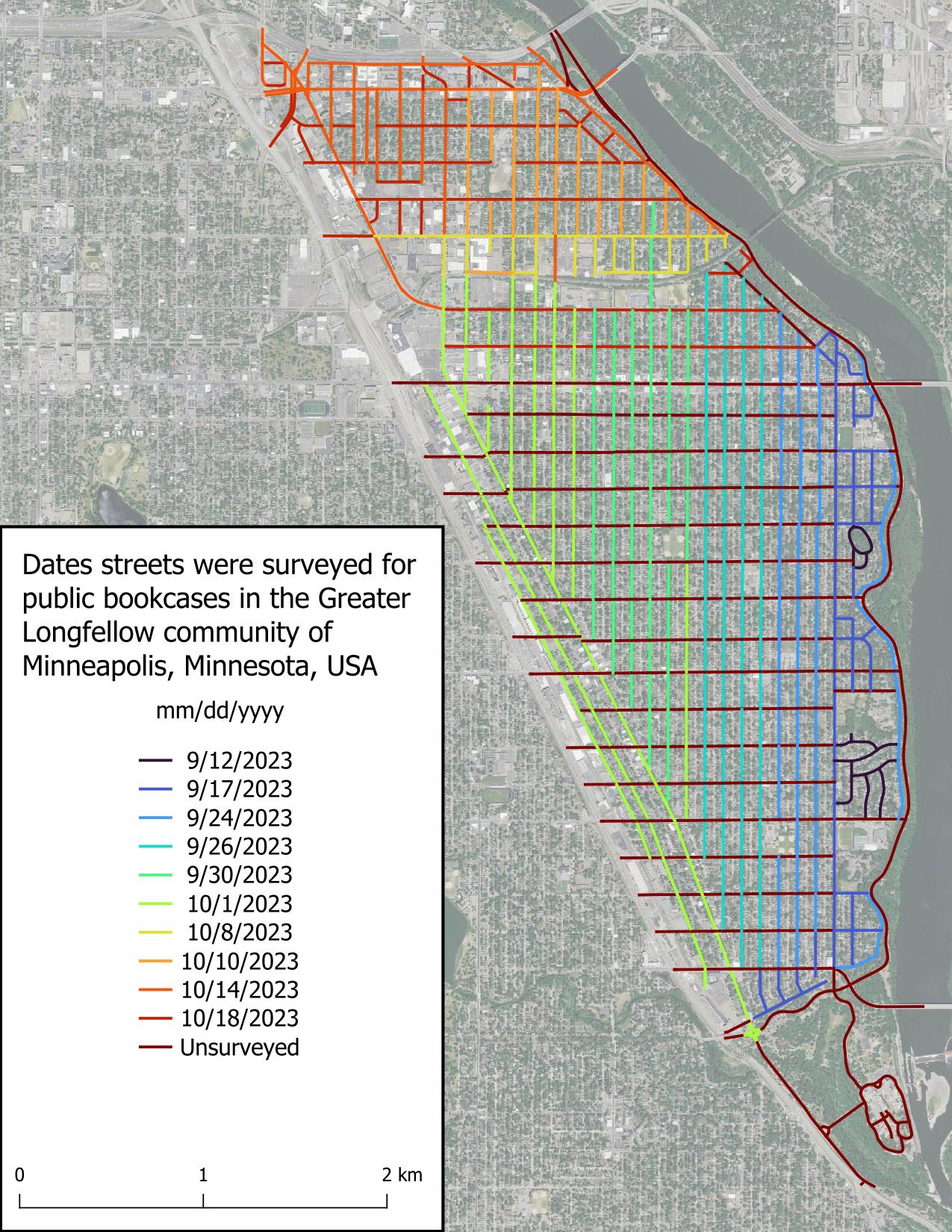
All* of Seward is surveyed! I found very few public bookcases (PBs) when surveying the remaining streets, which wasn’t surprising because most people put their PB in their front yard, and in Minneapolis, most front yards are on the avenues (north-south roads).

*It’s possible there are PBs in the entryways or at the base of large apartment complexes, and I didn’t attempt to circumnavigate each large apartment as that would have involved leaving the street.

Intro

Part 2

Part 3

Figure displaying dates roads were surveyed in the scope area. Roads are colored based on date, with the earliest date, 2023-09-12, in very dark blue and grading to red for unsurveyed roads.

It’s another previllage and opportunity to the part of local organizing committee (LOC) beand community volunteers and also selected as travel grantee to attend the hybrid state of the Map conference in Abuja Nigeria. collaborations with national research and development agency (NARSDA). It was very inspiring moment and knowledge shared was super amazing. I’m getting so much interesting In researching with geospatial tools after the presentation of #Afrigis, #cartoscope and #scistarter and Geoffrey keganttera presentation on food production system in Uganda was very educative . And also discussed more about technical support to local community members of open street Map foundation and sponsorship. I’ll like to appreciate the west and North African hub(WNH) for there special support to unique Mappers . (Afrigist)(URL) *##@{Alt picture}URL

Location: Kyayya, Barde, Jema'A, Kaduna State, Nigeria

It’s another previllage and opportunity to the part of local organizing committee (LOC) beand community volunteers and also selected as travel grantee to attend the hybrid state of the Map conference in Abuja Nigeria. collaborations with national research and development agency (NARSDA). It was very inspiring moment and knowledge shared was super amazing. I’m getting so much interesting In researching with geospatial tools after the presentation of #Afrigis, #cartoscope and #scistarter and Geoffrey keganttera presentation on food production system in Uganda was very educative . And also discussed more about technical support to local community members of open street Map foundation and sponsorship. I’ll like to appreciate the west and North African hub(WNH) for there special support to unique Mappers . (Text)(URL

Location: Kyayya, Barde, Jema'A, Kaduna State, Nigeria

It was indeed a great privilege attending the SOTM Nigeria 2023 conference in Abuja, at the Obasanjo Space Centre.

I was also a participant last year at the maiden edition of the SOTM conference 2022 in Port Harcourt. This participation aroused my interest and I have not looked back ever since. This year my very good friend and sister Hopeful Bafamodei invited me to be a part of the panel that talked about the cultural perception of genital mutilation. Thereafter my co panelist shared how mapping is needed to get data from areas identified as code red, where genital mutilation is being practised and how with the use of these data collected, help can come to such communities. Right there we had a live participant who shared her experience of what she had to go through in the hands of her very own father. I want to appreciate most importantly Dr Victor Sunday and all the LOC who made this event possible, The presentations made by Ian Tobia, Makcron, Eromosele and Hopeful, thought me one thing…….RESILIENCE. My passion for this conference is growing by the day and I am looking forward to more engaging content to be discussed during future events.

Hi, I use Street Complete a fair bit and it often shows up buildings with their areas drawn and asks what type of building it is.

But when I map some areas, the online editor won’t let me close the save set without having features for each area. If I choose generic “building” I don’t think StreetComplete is asking me anything at all, as though it has been settled.

So what’s a default feature for an unknown building (or unknown area for that matter - some bright white objects are very hard to tell if concrete, on the ground or a roof.) ??