 OpenStreetMap

If your reading this, then your probably seen one of my edits and want to know me. My Name is Yahia Darweesh and i really like to map things,
Diary Entries in English
Recent diary entries
I really thought I was going to be able to survey all of the Seward neighborhood today, but it got dark more quickly than expected. That really hampers my ability to see public bookcases, as you’d expect. Good to know for future surveys. It’s a solid start.
The weather has become substantially chillier than September and that’s really impacting my motivation. I wanted to wrap up this project before the first snow, but I’m wondering if my expectations were too high. Time will tell.
I really appreciate the kind words folks have left on my previous diary entry. I didn’t expect to get any acknowledgement, which is fine, but people left comments yesterday, over a week after I posted it. What a nice community OSM has!
Just got into this, very new.
The staff of the Northern New Mexico Welcome Center in Chama NM tells people not to rely on their GPS around here because it tends to be incorrect. It’s true. Google Maps has the wrong businesses listed at a location, anywhere from a few hundred feet to over a mile away. OSM for the area is barely touched as many of the businesses and buildings are not demarcated in any way.
So here I go! Hoping to do some good map editing in the area and expecting some OG OSM editors to swiftly tell me what I’m doing wrong.

See: https://en.wikipedia.org/wiki/Board_game_caf%C3%A9
How would you tag a board game cafe? The main attraction is the ability to ‘rent’ a table and play a variety of board games offered by the establishment. Oftentimes these places will sell cafe-type drinks and sometimes alcoholic drinks and food.
In my opinion, “amenity=cafe” and “amenity=pub” are not sufficiently descriptive because the implication is that the primary use is a cafe or pub, respectively. Adding a tag like sport=board_games or board_game=yes, while helpful, only indicate the availability of board games for play at a venue, but do not address the underlying issue that the primary use of the establishment is to play games not consume coffee or libations.
Posted by Romeo Ronald on 10 October 2023 in English.

As a proud resident of Juba, the capital city of South Sudan, and a team leader of the OSM South Sudan, I’ve witnessed the winds of change sweeping through our beloved city. It’s a transformation that holds the promise of reshaping our lives, empowering our community, and charting a new course for Juba’s future. At the heart of this metamorphosis is Juba’s journey towards becoming an open-source city, a path significantly influenced by projects like #ASKNet Access to skills and Knowledge, Wikimedia Community User Group South Sudan and open mapping—a benchmark of this revolution.
Embracing Open Source: What Does it Mean?
Before delving into the profound influence of open mapping, let’s grasp what it means for Juba to be an open-source city. Essentially, it signifies a commitment to transparency, accountability, and active citizen participation. It’s a city where information flows freely, governance is collaborative, and innovation flourishes.
The Role of Open Mapping: Charting New Possibilities
Open mapping stands as a pivotal benchmark of Juba’s open-source revolution. It’s a movement that has profoundly impacted our city, unlocking new possibilities and transforming the way we interact with our urban environment.
1. Navigating the City with Precision: Juba’s dynamic growth posed a challenge for residents in terms of navigation. Thanks to open mapping initiatives, we now have access to detailed, up-to-date maps of our city. Whether it’s finding the quickest route to work or discovering a hidden gem in our community, open mapping has made life easier and more convenient.
2. Empowering Disaster Preparedness: The significance of open mapping came into sharp focus during times of crisis. It’s remarkable how open mapping has contributed to enhanced disaster preparedness. In times of natural disasters, such as floods, the ability to access real-time information about affected areas and potential evacuation routes is a lifeline for our community.
We purchased 10 acres of land at this location

I’ve been diligently putting some truly boring information about my local High Street. Removing shops that don’t exist, adding new ones and adjusting opening times. It’s a shame businesses do not feel the need to do it themselves on OSM. I was wondering why is this, but then I realised that none of the navigation application I am using displays this information. I can check it on the Every Door and that’s pretty much it. Google Maps, by comparison, makes it really easy to see it and at the same time warns you of closing times, which makes it really practical in urban setting.
Having made comparison to the Map-That-Cannot-Be-Named, I realised how inaccurate Her* data is for my immediate neighbourhood. I’ve looked up some other places and though it would always take me more or less to the right location, the exact positions or addresses were off by quite some margin. At the same time, kudos to the interpolation heuristics that can find approximate addresses even in the absence of good data.
Especially that I am now realising how difficult addressing is. In my naivety I always though of streets as linear objects, with Hausdorff dimension 1 and ordered house numbers perhaps with an odd/even partition. Couldn’t be more wrong. I need to file a request to change the name of Dale Lane to Fractal Lane or Hausdorff Street (strasse?) to celebrate its many dendritic offshoots and arbitrary switch from consecutive ordering to odd/even ordering.
*Maps are feminine, right? Just like ships or cars.
Posted by barefootstache on 8 October 2023 in English.

Taking a brief look at the Croatian country side, one will notice that lots of the tracks/paths end without an exit. Additionally, when navigating at location, one will realize that only a fraction of such highways exist on the map.
How to plan a route for exploring?
The amount of exploration sections should reflect one’s physical capabilities. In the beginning about one exploration per route should suffice and can be increased through practice and knowledge of the area. One shouldn’t bite off a bigger chunk before one can handle it.
In this example of about 16km route
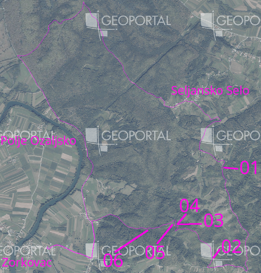
I chose one exploration section every 5km in such a matter that not more than 500m of distance was needed to be explored.
There was one section in the north that was an easy gravel highway connection,
Posted by umbraosmbr on 8 October 2023 in English.

STATE OF THE MAP BRASIL 2023
CURITIBA - BRASIL

UMBRAOSM - union of brazilian openstreetmap mappers
UMBRAOSM
Boot scrapers have fascinated me since Helge Schneider’s musical “Mendy das Wusical” in which they play a very important role. #stiefelabstreifkante (It’s a somewhat absurd musical by my favourite German comedian…)
I remember that when I moved to Ireland I kept sending my sister pictures of the ones I came across, because she also likes the musical and the comedian.
For some years now I have been thinking that it would be interesting to map them. Partly because I wanted to know how many there are in Kilkenny and where and also, you never know who might be interested in this data in the future, so OpenStreetMap is the obvious choice to record them.
 A.-K. D., CC BY-SA 4.0 https://creativecommons.org/licenses/by-sa/4.0, via Wikimedia Commons
At this point, if you get tired of reading - I’ve made a video about it: watch video on YouTube
While I was mapping house numbers and other things in Ballyragget today, I noticed something curious: Buildings with “Step” or “Steps” in their name. There is a “Step House” in Ballyragget (check on OSM), probably called thus, because it has 5 steps leading up to the front door (a common feature in Georgian buildings). To my knowledge, there are only one or two more houses like that in Ballyragget, so having steps outside your front door must have seemed remarkable enough for people to give it that name.
 A.-K. D., CC BY-SA 4.0, via Wikimedia Commons
Then two other cases came to mind: the Steppes Bar in Callan (check on OSM) which seems to be named after the steps to the left of the entrance. Weird plural, but maybe it’s from ye olde times.

I’m doing really, really detailed reed beds in Etulia Nouă, Moldova.
Moldova and it’s state
Moldova is not very detailed. In fact, most natural features aren’t even mapped. There are only roads, rough shapes of towns and town nodes. I’m currently creating lots of detailed reed beds and natural features there, especially near Lake Cahul.
Start detailing!
 I invite everyone to start detailing the undermined country of Moldova. It’s really beautiful! I’m detailing areas around Etulia Nouă, but you can pick any area you want, like Bălți, Giurgiulești, Comrat.
I enjoy reading people’s diary entries, so I’m starting my own. My current project is mapping public bookcases (PBs) in neighborhoods near me.
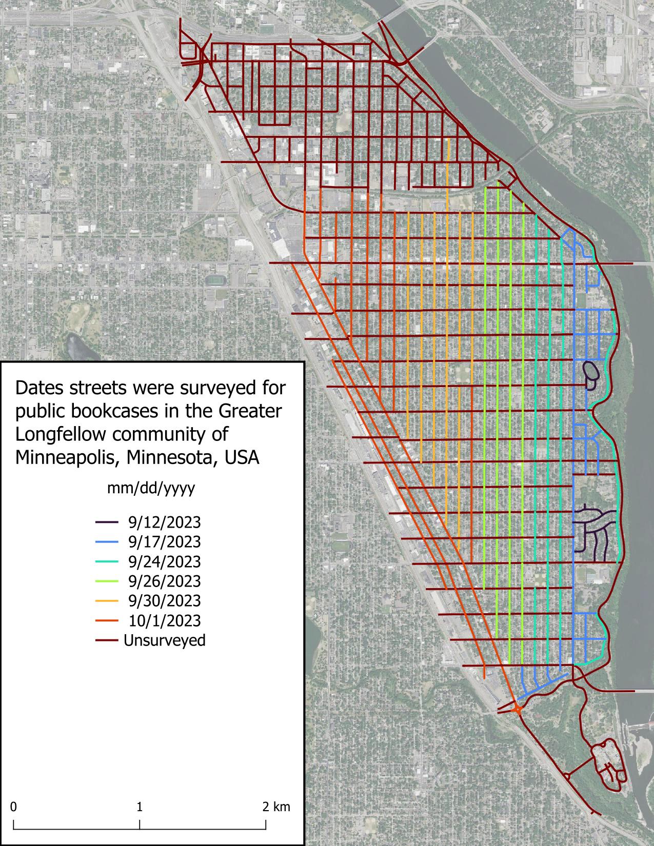
I started this project because I chance upon PBs when going for walks and can never remember where a PB is when I need one. There’s a map of Little Free Libraries (LFLs), but adding PBs to this map is “pay to play” which I don’t like, in addition to not displaying unaffiliated PBs. Other secondary goals include:
It seems I have developed a reputation in Ireland and the UK about my history mapping, because SK53 had tagged me in a toot about Martello towers. At first, I somewhat brushed it off, but as he probably knew, my interest was eventually triggered and I looked into the matter.
I remember that DeBigC was the first to tell me about Martello towers, but I can’t remember if he used a specific example or just shared his interest.
For those who aren’t familiar: Martello towers were built by the British Empire at a time when they were still ruling the waves, especially around the time of the Napoleonic Wars, when there was a threat of a Napoleonic invasion into British territory. They continued building them in port towns, so mostly along the coast, but not all of them are coastal. Apparently (according to Wikipedia), they are usually round and built in two levels with the guards living in it (i.e. building). They placed a cannon on the top which had a 360° reach, although one hopes that they only pointed it seawards.
The good news was that a lot of them were already mapped on OpenStreetMap, mostly with name=Martello Tower. The bad news (as pointed out in the toot) was that there was no consistent tagging scheme. Most of them were mapped as man_made=tower, and some had some sort of historic tag on them (ruins/ castle/ yes etc), but few were mapped as buildings. So, I came up with historic=martello_tower, skipping the proposal process and documented the tagging scheme in the wiki.
In this post, I’ll try to give some insights into the more recent work and workflows of the global State of the Map (SotM) program committee. After having been a member of the SotM program committee for the last couple of years, I figured this might be useful or at least interesting for other program committees or content teams.
Please note that the views and experiences expressed in this post are my own and that they are mostly based on my memory. I’m also trying to just describe how we worked, which may not be the best way, maybe not even a recommendable one, but one that seemed to work for us. Just because it worked for us doesn’t mean it will work for others though, and vice versa.
In some way, this post is also a follow-up to a previous post of mine where I wrote about the software and services behind the State of the Map. I’ll try to avoid duplicating content, so see the previous post for more information about the tools and services that were used.
Organisation
As long as I’ve been on the program committee, it was always organised such that it was mostly split into a ‘core program committee’ (I’ll refer to it as ‘core team’ in the rest of this post) and the full program committee (I’ll refer to it as ‘program committee’ in the remainder of this post), which included all members including the core team. I don’t remember if this split was a conscious decision, if it just emerged based on asking the program committee members about who wanted to help with which tasks, or if there was another reason. But at least so far, we haven’t had a reason to change this.
Program Committee
The primary tasks of the program committee were reviewing and rating the submissions of the talks, workshops, etc. and providing feedback on e.g. the draft for the call for participation before it got published. Once the call for participation was published, the program committee members were also encouraged to announce it in their local communities.
Core Team

Mapping a large urban area in its entirety is quite a rare task.
Pyongyang, the city I mapped, is an urban area 15km wide by 12km long. It took me over a year from April 2022 to May 2023 to complete, particularly the buildings and roads. But I’m really pleased with the result: just look at the state of the map!
Mapping a capital in its entirety is rare, and for several reasons:
-
Firstly, because all the major urban areas in the West have already been mapped. This leaves the countries with the fewest contributors, whose capitals may already have POIs… but rarely all the buildings and roads.
-
Secondly, because you need a good amount of motivation, when you’ve reached the 60,000th building and you’re still halfway there… well… you have to hang in there! I also think it’s hard to imagine embarking on such a lengthy mapping project. Imagine if you wanted to undertake a project like this for Hanoi… unfortunately it can be discouraging from the outset.
But mapping by small parts, by neighbourhood, is a method that worked quite well for me, so maybe it will work for others!
In short, there are still many capitals to be mapped on these basic themes! But getting started, and above all keeping going, is a fairly difficult task because you need to stay motivated. If you do, hang in there!
Mapping Pyongyang
Beginning of the idea
When I started mapping in North Korea and writing the contribution guide to the country (cf. my previous diary) I never thought I’d be embarking on such a task because… it’s a capital in fact! It’s big, it never stops, it’s long, you never see the end of it! But in fact it is ;)
But I didn’t start mapping in North Korea by saying to myself “I’m going to map the whole capital”. In fact, for a long time I never even thought about it. In fact, it’s a project that’s taken place in several stages.

- Sparse OSM tools: osm.org/user/ivanbranco/diary/401437
- OSM Links from another user diary: osm.org/user/GrapeMapping/diary/401815
- Quick interactive analysis of the map stats and how they evolve over time (e.g. “how many trees are in the map in Italy”), includes estimation of completeness https://dashboard.ohsome.org/
- Gallery of cartography projects, mainly about Berlin https://hanshack.com/
- 30 Day Map challenge: https://30daymapchallenge.com/
- Even more beautiful maps: https://tjukanov.org/
Posted by AlmostSurelyRob on 30 September 2023 in English.
Last updated on 25 November 2023.
… is what I am doing these days.
I’ve installed Terracer in JOSM software and I am learning JOSM along the way a bit. I also got Every Door on my mobile. It is much more versatile for correcting information about amenities than StreetComplete and at the same time still quite convenient to use.
Most of my tags still come from StreetComplete though. I find it particularly rewarding to answer questions for disabled or visually impaired people. I regularly see two elderly people on my local high-street and I see two kids, boy and a girl walking with sticks and I do hope that maybe one day the detail that people are putting into OSM will make some viable navigation apps for them. I also learnt about traffic lights with vibration mechanism underneath.
The difficulty is arbitrariness in tagging buildings. On the estate I live there’s a very old house which my wife describes as a “farm house”, but there’s no farm here any more and the building is used for residential purposes. I also learnt a very reasonable distinction between house, terraced or semi-detached house. I’d like to follow the tagging “building=house” “house=semidetached” or other to be more specific.
And how difficult must be to be a postman! Corner houses are particularly tricky. I came across semi-detached corner houses which seem to belong to different streets. There’s also lots of houses with names and no numbers and I think quite a few new blocks which do not exist on OSM. Will need to review with aerial imagery. I know of the offsets, but the GPS on my mobile is very unreliable so haven’t figured out yet how to correct it yet.

On September 26 IHE Delft and the Humanitarian OpenStreetMap Team organized a mapathon to map the areas affected by the earthquakes in Morocco and the floods in Libya.
Many new mappers attended the mapathon. We collectively uploaded 813 changesets containing over 50.000 total map changes in the span of only 3 hours.
Posted by Waaslander on 29 September 2023 in English.
Last updated on 16 October 2023.

Intro
The Belgian train operator NMBS (Dutch)/SNCB(French) is seeking to improve travelers guidance along its stations and for this it wants to improve the OpenStreetMap data quality of its stations osm.wiki/WikiProject_Belgium/Stations. One such project aims to have a better view as to where a certain train wagon would stop on a given track. This as to now exactly where the 1st Class wagon is, the bike wagon is and so on. However to be able to show this it needs a detailed view of platform zoning, the rail signs and the signaling. (Below you will find what those signals exactly mean.)
Zoning
What:
Some stations divide its platforms in zones. You have in general two types of zoning (I call those two types) general zoning and specific zoning platforms. On general zoning platforms you will find panels A B etc. besides the platform number. Often you will even see those numbers reoccur multiple times on a specific platform. On specific zoning platforms however you will find panels like B2, B1, A1, A2 and those are uniquely placed along the platform.