Diary Entries in English

Recent diary entries

Posted by Klenje on 16 October 2023 in English. Last updated on 22 October 2023.

One of the greatest things in OpenStreetMap is that, when you start looking beyond the basic features, the amount of details and specific themes you can use to enrich the map is practically endless (special mention for the guard stones mapping)

An example which may go unnoticed at first is playground mapping. I became interested in this due to the frequent visits, and I started as usual from the wiki.

The goal of this post is to have a quick summary on how to map playgrounds in order to hopefully help fellow mappers around the world interested in this topic.

Why

Because having the data in OpenStreetMap will allow your favorite app/website to let you search and display easily the existing playgrounds and their features, removing one more reason to use other providers, while making kids and parents happy.

How to map

Level 0 - starter

Minimal mapping is to place a node tagged with leisure=playground in the playground location.

Note: in some places you can also find single play installations which are not part of a playground, those can be mapped directly as nodes without a playground.

Level 1 - basic

Map the playground as an area and add tag leisure=playground and any other relevant tag on it (wheelchair access, minimal age and so on). This opens up the possibility to go further into details as explained just below.

If the playground has a fence, you can also add that to the playground area with the relative gates (and possibly some footways to reach them for the routing engines!)

Level 2 - medium

Map the devices and installations as nodes within the playground area. You can find a detailed list of possible values on the wiki.

Besides that, you can also map any additional amenity like benches or drinking water that are located within the playground area.

Level 3 - advanced

See full entry

As I reflect on my journey to the State of the Map Nigeria 2023 (SotM Nigeria 2023) conference, the words that come to mind are unforgettable, inspiring, and hopeful. This year’s event was a unique blend of challenges and triumphs, new friendships, and a shared vision for the future of open mapping in Nigeria.

Unforgettable Connections: The most remarkable aspect of SotM Nigeria 2023 was the people I had the privilege to meet. Despite the challenges posed by limited funds and logistical hurdles, participants from different corners of Nigeria and beyond gathered in Abuja with a shared passion for open mapping. Each conversation was a new opportunity to learn, collaborate, and inspire one another.

Inspiring Endeavors: The conference sessions were a wealth of knowledge and inspiration. From innovative mapping technologies to community-led projects, the presentations showcased the incredible work happening within the Nigerian open mapping community. The dedication of speakers, volunteers, and attendees left me inspired and eager to contribute to these initiatives.

Hope for the Future: While navigating the constraints of limited funds, we shared a collective hope for a brighter future. The challenges we faced underscored the importance of growing support for open mapping in Nigeria. I was fortunate to witness the commitment of the organizing team as they worked tirelessly to make the event a success, and I left with hope that future SotM Nigeria conferences will have the resources needed to flourish.

SotM Nigeria 2023 was a testament to the resilience of the open mapping community in Nigeria. Despite the obstacles, we came together, learned, shared, and celebrated our common goal. The connections made, knowledge gained, and the spirit of collaboration will continue to inspire me as I work towards a more vibrant open mapping landscape in Nigeria.

See full entry

In a world where technology is at our fingertips, it is easy to forget that not every corner of the globe has been extensively mapped or can enjoy the benefits of modern cartography. This is especially true in regions torn by conflict, where infrastructure and basic services have been devastated. South Sudan, a nation born out of conflict, is one such place where mapping takes on a unique and critical role.

South Sudan, the world’s youngest country, has been grappling with conflict since its inception in 2011. The violence has often been drawn along tribal lines, making reconciliation and rebuilding particularly challenging. In such a fragile post-conflict environment, the work of organizations like OSM South Sudan takes on profound importance.

The OSM South Sudan Initiative

OSM South Sudan, an open mapping community, has taken up the mantle of mapping the nation’s remote and conflict-affected areas. Mapping in such an environment is not just about geographical data; it is a tool for social healing, reconciliation, and empowerment. The volunteers involved in OSM South Sudan are driven by the belief that the act of mapping can foster peace and unity in a divided land.

Concept Mapping as a Starting Point

To initiate this endeavor, OSM South Sudan starts with a fundamental step – concept mapping. The first phase of their approach is all about introducing the local communities to the concept of mapping in a way that resonates with their everyday lives. By asking simple questions like, “What would you do before you build a house?” the volunteers create a bridge between mapping and the participants’ own experiences.

See full entry

Location: Hai Buluk, Juba, Central Equatoria, South Sudan
Posted by Karinorz on 15 October 2023 in English.

Introduction

Open Her Map team was consisted of 3 people, Mirnayani (Indonesia), Shafiya (Sri Lanka), and Karina (Indonesia). As a follow up of She Leads She Inspires program, Open Her Map was selected to be one out of 10 grant beneficiaries to make a platform to gather information related to the availability of women-only spaces in public facilities, such as the availability of breastfeeding rooms, kids’ playing spaces, women-only restrooms, ladies’ parking spaces, women-only rooms, women-only hours service, and many other women-only spaces’ necessities.

Outcome

By the end of the project, the project achieved the following: Women participants have increased sense of safety and comfort in terms of women-only spaces in public facilities One pilot location in each Jakarta and Moratuwa have increased the number of mapped women-only spaces in public facilities Women participants have increased knowledge on mapping women-only spaces using OpenStreetMap

Output

See full entry

Location: RW 10, Pela Mampang, Mampang Prapatan, South Jakarta, Special Capital Region of Jakarta, Java, Indonesia
Posted by gvwaal on 14 October 2023 in English.

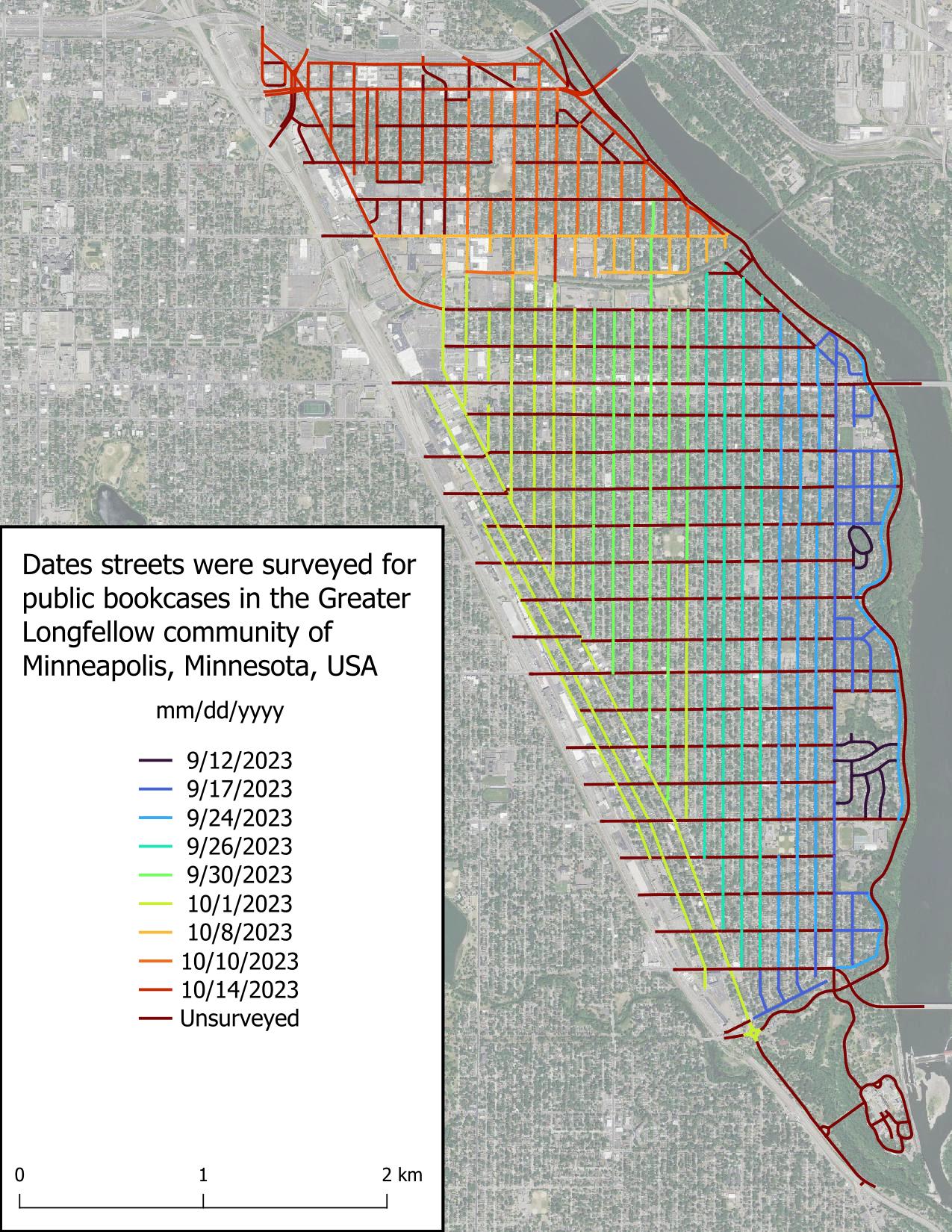
I surveyed most of Seward’s avenues today, but what I’m most excited about is having finished surveying the three streets I was least excited about (9th St S, Franklin Ave E, and Minnehaha Ave S), leaving calmer streets for the rest of the project.

Unsurprisingly, I found few public bookcases (PBs) today. I believe this is due to the non-single family home nature of the roads surveyed, and in the roads lined with single family homes, the economic conditions of the inhabitants.

Shoutout to the Feminist Book Club for being the only non-residential entity (witnessed so far) to host a PB.

Intro

Part 2

Figure displaying dates roads were surveyed in the scope area. Roads are colored based on date, with the earliest date, 2023-09-12, in very dark blue and grading to red for unsurveyed roads.

Posted by Zverik on 14 October 2023 in English.

Spent today writing a new Python library. Super useful if you are making command-line OSM processing scripts:

https://github.com/Zverik/cli-oauth2

With it you add OAuth2 authentication in just one line of code (well, 3-4 after PEP8).

auth = OpenStreetMapAuth(
    client_id, client_secret, ['read_prefs', 'write_api']
).auth_server(token_test=lambda s: s.get('user/details'))

user_name = auth.get('user/details.json').json()['user']['display_name']

This line starts a local web server, opens OSM OAuth page, catches the redirect, stores the token on disk, and returns a requests session that also prepends the API endpoint to its parameter.

Not very secure — but it doesn’t need to be. One drawback is when publishing sources to github, you would need to publish your client credentials as well. Or just read then from a config file, idk.

Already updated my Simple Revert and OSM to Sandbox scripts to use it. Hope it helps!

It’s another previllage and opportunity to be the part of community volunteers an also selected as travel grantee to attend the hybrid state of the Map conference in Abuja in collaboration with national research and development agency (NARSDA). It was very inspiring moment and knowledge shared was super amazing. I’m getting so much interesting In researching with geospatial tools after the presentation of Afrigis, cartoscope and scistarter and Geoffrey keganttera presentation on food production system, An also discussed about technical support to local community members of open street Map foundation and sponsorship. I’ll like to appreciate the west and North African hub(WNH) for there special support to unique Mappers network Nigeria and other international donor. Looking forward to appreciate each and everyone for there time and sharing vital thought this hybrid conference. I therefore I want to appreciate national research and development agency ( NARSDA) for collaboration and opportunities. I want to use medium to appreciate our national coordinator for his super capacity coordination and knowledgeable experience share.

Posted by prispe on 14 October 2023 in English.

SotM Nigeria 2023 ended well to God be the glory. There was a lot of inspiration I got from the conference. I met with new people and the like. During the conference, we the females use it as an avenue to celebrate International Girl’s Child Day. Where I presented a talk on “how to use technology to fight against genital female mutilation”. I liked and explained how to leverage the technology such as 1. Information and Education, 2. Online support and counseling, 3. Create a chatbot, 4. Develop a mobile app that can help in data collection. In the cause of this, a call was put through to a lady who shared her experience at the age of 21, with 7 months pregnancy, her father took her to where she was mutilated. I benefited from the conference as one of the travel grantee. #Unique mappers network Nigeria #HOT #WNhubsummit #Oyomappersteam.

Posted by Kubula on 13 October 2023 in English.

Along the way the way the journey became rough but we still reached our destination. The conference started on the 11th of october 2023, i learnt alot and what really inspired me was the talk of the OSM secretary who talked about how the OSM community was formed,their challenges as well as how they persevered. I also got to meet a lot of new interesting people and it was fun. As a travel grantee, it was a priviledge as this was the first time I was visiting abuja

Thank you UniqueMappersNetwork Thank you our sponsors Proud UniqueMapper #UniqueMappersNetwork #SOTMNIGERIA2023

I want to use Overture Places to improve OSM, and want to share a few ideas on that.

First the data is worldwide, and there’s definitely added value there to mine. Here’s Brandon Liu’s map over Santo Domingo.

However it’s a mixed bag. Adjusting confidence score is helpful. But even then, some things are in right location, some are already in OSM, some are closed, or miscategorized. It takes careful analysis to find places that could added to OSM. Wille did a great job examining his local area

This is not a harsh critique – it’s tough data to manage. There’s value. I’d like a workflow that gets at deriving that value, fast. I think it’s a combination of something that enables the kind of analysis Wille did, along with an easy way to edit OSM.

I don’t think this needs to have a fancy entity matching process between Overture and OSM. Choose an area. Generate a list of features in Overture, with confidence threshold, and filtered to feature classes of interest. Show both Overture and OSM on the map. Work down the list, examine the map, take an action in OSM if necessary (adding, updating, or nothing), then mark the task with the action.

I guess this could be done through MapRoulette? Though tasks there seem typically driven by analysis of OSM objects, not 3rd party data to conflate. RapID? Not possible to create your own tasks. What about adding Overture as an overlay in iD? Another way?

Yesterday I gave a keynote talk to State of the Map Nigeria in Abuja. Despite numerous technical difficulties (I think I was on a phone giving the talk within a big room?!), I hope I got some ideas across to at least one person who needed to hear them.

I decided to focus my talk on what it’s taken to feel accomplished in OpenStreetMap. And I do, so much personal and professional success has come from being a part of this community. It broke down to 9 points.

Up front I acknowledged Connection. It still feels like a miracle that I could talk from Santo Domingo to the Obasanjo Space Centre. When I was growing up, this was pure science fiction. Today we can connect with nearly anyone in the world. The power of this can not be overstated, and is not nearly leveraged enough. It’s the essential piece of what makes OSM works in my opinion.

Next Inspiration. Have a problem that moves you. You don’t need to know the solution up front, that takes time. Figure out how data and community apply. I started working on the idea of HOT after the Indian Ocean tsunami, and Hurricane Katrina. Disaster response is extremely hard, but it seemed like information flow about place could be a solved problem.

Translation is a powerful position to be in, sitting between two worlds and helping them to talk to each other. I don’t mean linguistic necessarily, but conceptual. HOT sits within two places that operate very differently – humanitarian and open source. In the OSMF, I’ve been working to help organizations and community better understand each other.

Commitment is essential. Working on hard problems takes years, at minimum. Map Kibera had a great map in OSM within weeks. But it took years until there was a direct benefit in Kibera. We could have celebrated in 2009 (and we did) but so what – we couldn’t stop there. I didn’t consider any solid impact until 2013, at the next presidential election, where the map became essential for the operation and participation.

See full entry

Unlocking South Sudan’s Digital Potential: The Impact of IGF on Open Knowledge Access and Open Source Tools

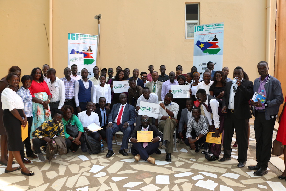
Group Photo During the recently concluded IGF 2023 On 10.October. 2023, South Sudan took a significant step towards realizing the dream of an inclusive digital future by hosting the Internet Governance Forum (IGF) under the theme “The Internet We Want: Empowering All South Sudanese People.” This momentous event held at the Hotel provided a platform for stakeholders from various sectors to come together and address the critical issue of digital access in a country where connectivity costs are among the highest in East Africa.
The IGF in South Sudan served as a rallying point to discuss, deliberate, and take action on the challenges of the digital age, with a particular focus on open knowledge access and open-source tools. Here’s what this event means for South Sudan and its journey toward digital inclusivity.

Digital Divide in South Sudan: A Stark Reality

See full entry

Location: Nyokuron West, Juba, Central Equatoria, South Sudan
Posted by Matt_ on 12 October 2023 in English. Last updated on 18 October 2023.

I wanted to share my experience finding and fixing a misplaced lake and dam as an example of what I’ve been working on in case it’s of interest to anyone else. I think I’ve picked a good example of what I’ve been finding. I also tried to make it as short and to the point as possible and then made this too long anyway. Here we go!

Finding a problem

Rowe Lake as a node in a forest

Rowe Lake (gnis:feature_id=1640193) (node) and Rowe Lake Dam (gnis:feature_id=1640194)(node) were two nodes on the side of a mountain next to a road in Monroe County, Tennessee. There were two problems with that:

  1. On satellite there was no lake or dam visible in the area. Which isn’t proof this is the wrong location, but it looks like solid trees.
  2. The GNIS tags on both nodes had them in county 157: Shelby County, over 300 miles away on the other side of the state.

Not finding a solution

See full entry

Posted by juminet on 11 October 2023 in English.

NB: cross-posting of https://www.nobohan.be/2023/10/06/openardennemap-en-carte-web/ (in French there)

I finally set up a tile server for OpenArdenneMap! See this webmap, and this article for more details.

OpenArdenneMap is a cartographic map style dedicated to printed maps, so it does not render ideally in a web map server. It is built as a “cartoCSS/Mapnik” style and is also available as a QGIS style for some time now. Since it is based on Mapnik, this style can be used for generating map tiles, although it is primarily designed for printing.

If you’re looking for some ready-to-use maps to print, have a look at hiking.osm.be.

Location: Au Pigeon, Marbehan, Rulles, Habay, Virton, Luxembourg, Wallonia, 6724, Belgium

The devastating events in Morocco (earthquake) and Libya (floods) happened within two days of each other on the 08 & 10 September 2023. Both have meant large scale destruction of infrastructure and thousands of tragic deaths and injuries.

OSM communities in both countries (OSM Maroc and OSM Libya), alongside partners, have responded and with huge support from mappers from the OSM community across the world.

The following diary entry is an update on a similar one from 18 September.


The latest…

The open mapping community response

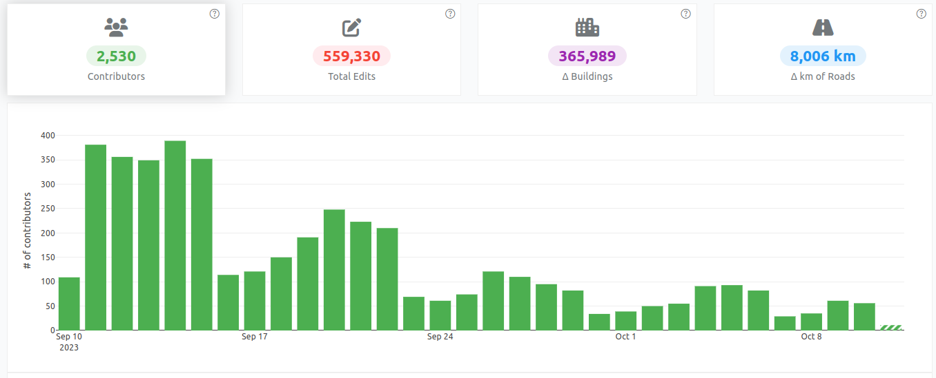
More than 2,500 OSM mappers have added data to support responders in Morocco. Two projects on the HOT Tasking Manager has so far been completed (mapped and validated) and there are four more available for mapping.

Contribution statistics for the Morocco earthquake response

Contribution statistics for the Morocco earthquake response

See full entry

Posted by Richard-Degenne on 11 October 2023 in English.

Today, during lunch break, I went on my first survey sortie. Up until now, I mostly mapped from home based on local knowledge and info found online. But I want to add house numbers to the town I live in and the only way to do it properly is to get out there!

It went pretty well, even though some people found suspicious a guy just lurking around with his phone out. I’ll keep going over the next few days, it’s actually a lot of fun! :D

Location: Le Pontet, Le Soupt, Charbonnières-les-Vieilles, Riom, Puy-de-Dôme, Auvergne-Rhône-Alpes, Metropolitan France, 63410, France