Diary Entries in English

Recent diary entries

Introduction

Hi everyone, this is my final report for my GSoC’23 project: support Vespucci preset extensions in JOSM.

Previous diary entries

Getting started

Project Summary

About the project

Vespucci utilizes the JOSM preset format but has extended the configuration to work better outside of the narrow realm of JOSM. The project aimed at adding these additional extensions in JOSM. These extensions include deprecated, regions, exclude_regions, value_type, and alternative. see Vespucci preset documentation

Work done

The presets can have the additional attribute “regions”, which will contain the ISO codes of the countries to which the preset is applicable. “exclude_regions” will invert the meaning of “regions”, i.e., the preset should not be applied in countries specified under “regions”.

A warning message is displayed before the upload if the preset is applied in the country not defined in the “regions”.

See full entry

Posted by barefootstache on 27 August 2023 in English.

It has been just over a week that I have accomplished the 365 daily MappingChallenge (Mastodon) and decided to persist with a 100 weekly challenge instead. One of the main (Mastodon) reasons is how daily contributions are being processed based off of UTC+0, which is manageable if one does not travel. Further this week I have decided to use the OSM Diary over Mastodon, since this way I can do long form entries with less constraints and possibly reach a larger audience.

Quick overview

In week 54:

  • 34 change sets created in total
  • 5327 node changes in total

all were done within JOSM.

Changes

  • extracting sidewalks from roads
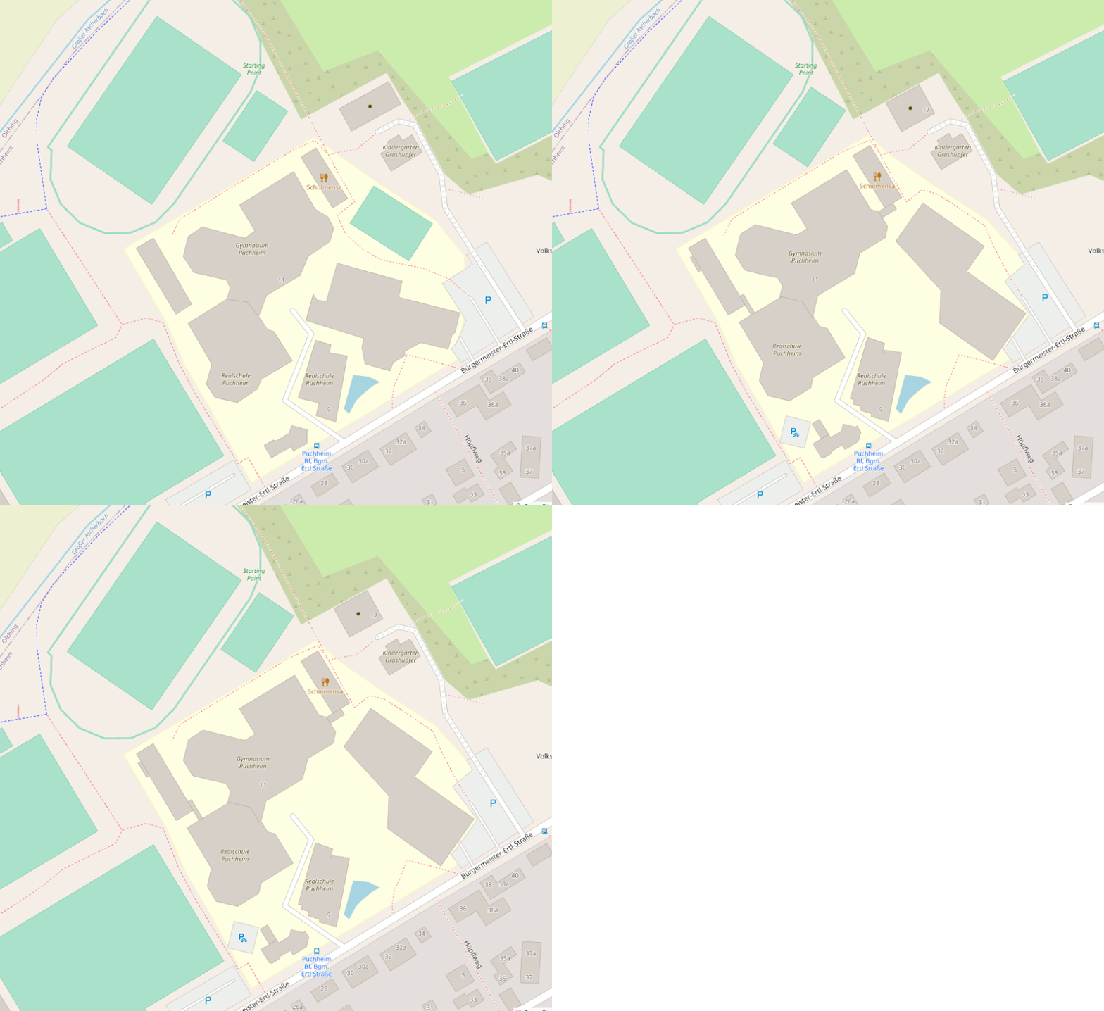
  • splitting up schools
  • adding roof shape and roof material

Puchheim Realschule and Gymnasium

Location

Before and after animation of building geometry changes of a school district

Puchheim Mittelschule and Grundschule

Location

See full entry

Posted by b-unicycling on 27 August 2023 in English.

Heritage Week is an annual number of days (it’s longer than a week by now) taking place in August in Ireland. There is a wide array of events including talks, workshops, guided walks etc all around built and natural heritage. This year’s topic was “Living Heritage”.

Recording Milk Churn Stands

Early on in my effort to map milk churn stands in Ireland, I thought that it was not sustainable for me to travel around the country and look for the needle in the haystack, when the locals knew where all the milk churn stands were. So I decided to give a talk which would hopefully raise awareness about the endless possibilities OpenData, OpenSource and OpenStreetMap offers. It was supposed to be a workshop, but I had a funny feeling that the demographic of the audience would turn it into a talk. It actually turned out to be the first event on the Heritage Week website. The Minister for Heritage (, Housing & Electoral Reford) who I happen to be friends with offered to attend, and of course I thought that would be a great opportunity to promote OSM.

The venue was a library in a rural town which used to have a creamery, because I thought it might attract people who remembered the time when milk churn stands (aka creamery stands) were still in use. Once the librarians heard that the minister was attending, they got a bit excited and let the regional library manager know. The big day arrived on August 16th, and he did attend. I had brought the OSM Ireland pull-up poster for the photo op, and also for branding awareness reasons. - So many people still don’t know about OSM, even though everyone by now must have been exposed to it one way or another.

See full entry

Location: Talbotsinch, Talbot's Inch, Kilkenny Rural, Kilkenny, County Kilkenny, Leinster, Ireland
Posted by miku0 on 27 August 2023 in English. Last updated on 29 August 2023.

Hi everyone,

I am thrilled to present the final updates on my ongoing project focused on enhancing the search experience in Japan. For reference, you can find the previous blog entry here and the interim report here. In the last interim report, I introduced the changes related to the sanitizer. The associated pull requests for these changes can be accessed here. Regarding this article, you can find the pull request for this specific change here.

In this final update, I will provide detailed insights into our efforts in the “Address Search” realm, specifically related to the tokenizer.

Enhancements in Address Search Methods in Japanese

Japanese Addresses are written in one large string without spaces and Nominatim needs help to find the words. As an illustration, for instance, consider the Japanese address “東京都新宿区西新宿2丁目8−1”. Although it lacks spaces, it can be divided into internal segments such as “東京都” (similar to a state or district), “新宿区” (akin to a city), “西新宿” (akin to a town), and “2丁目” (a block). However, Nominatim only divides such addresses using ICU (International Components for Unicode) transliteration, not based on this semantic division. Fig.1 illustrates a debugging example with multiple potential candidates.

See full entry

Project name: Guidelines for mapping of wetlands and floodzones. Case study of Lower Sinu river basin in Caribean region of Colombia

Description

The goal of the project is to test the mapping case study to build a document with guidelines for mapping in this areas. It comes from the experience of the “Water telling stories” Social Movement, a root social initiative of near 47 communities, grassroots organizations from 5 municipalities around the ecosystem of the Lower Sinu River Basin, located in the north coastal side of the Cordoba Department, in the Caribean region of Colombia. As part of the technical support team of the movement, Iḿ leading the mapping project for this area.

More info:

I used the jamboard to put one the difficulties from my side:

“I can’t find allies for my legacy project from my OSM local and regional Community. I need people to help me to identify the needs of mapping wetlands and flood areas.”

I’m working with one volunteer from Youth mappers in Colombia who is interested in help to this mapping project. As I said in my diary entry, previously I had lead one mapping session to invite people to join our tasking manager mapping task to map Bajo Sinu “Lower Sinu River basin”.

In my action plan I have:

See full entry

Location: Lorica, Bajo Sínú, Córdoba, Colombia
Posted by Midnightlightning on 26 August 2023 in English.

I found myself down a rabbit hole searching for a good tool for a specific use-case today. The use case is trying to send someone a link to a specific geographic area. My use-case was for directing another person to a specific meetup spot (“meet me over here by the northeast corner of the parking lot”), which doesn’t need to be a point but could be something like a 10x10 foot square and still get the point across. Additionally, there’s a use-case for it in leaving “map notes” within the OSM system: some notes need to indicate very precisely “there’s a missing feature RIGHT HERE”, but others could be more general (“this area is a forest”), and if the note could be tied to a zone, that could be more helpful.

I have used what3words in the past for this, and that site has a nice, short URI scheme to share with people, but the map layers don’t include OSM options, so I started looking for ways to combine the two. That lead me to the wiki page that highlighted many shortcomings with that system (as it’s a centralized, copywritten service). So I went hunting for other systems that could fill the same need of sending people a nice link to “meet me here” (small area) or “I live here” (building-sized area), with OSM tile data under it.

Of the many options for “geohash”-style approximations of latitude/longitude, it seems “Plus Codes” (formerly “Open Location Codes”, OLC) have gained traction as a way to refer to small and large geographic areas, but the main https://plus.codes/map site (the key one that allows seeing a visualization of the grid system, so you know how big a region you’re referring to) only uses Google Maps tiles as the underlying visual, so aesthetically is the same as what3words (telling someone “meet me at the corner of the parking lot here:” with https://plus.codes/86MG4JJJ+HHR is essentially the same experience as giving them https://w3w.co/handy.lame.treats).

See full entry

Posted by ybon on 25 August 2023 in English. Last updated on 28 August 2023.

Since a few month, uMap has been integrated in a French state incubator, so things are moving quite a lot!

uMap is now ten years old, and is deployed on many instances around the world. The one I know well is hosted by OSM France, and is close to reach one million maps created and 100.000 users.

This incubation program is ported by the French “Accélérateur d’initiatives citoyennes”, it includes coaches and a small budget for non tech needs (UI/UX…). One goal of this program is to find financial support for uMap development and maintainance. A French administration, the Agence pour la cohésion des territoires, is the first uMap financial backer since a few months. This allowed us to put up a small team to work, part time, in uMap:

That’s great news! Until then, uMap was 100% developed on my spare time.

uMap is used a lot by French public agents, and this explains the support from the French state, to make this tool better, and more official. For this, a first step is an “official” instance for public workers:

https://umap.incubateur.anct.gouv.fr/fr/

We’ll be at the NEC - Numérique En Communs event (Bordeaux, France), on October 19th and 20th. See you there for more news and announcements!

What’s new in uMap, then ?

First, a huge cleaning, upgrade and bug fight in uMap code. Since a few years, my time available for uMap has been very low (I’ve been a baker for two years…), so the code urgently needed more love.

What else? Here are a few of the notable changes made recently in uMap, let’s go!

Docker image

Finally!

See full entry

Posted by Neelima Mohanty on 23 August 2023 in English.

Hello everyone, I am here again with the last Blog of my journey as an Outreachy intern. For those who don’t know me , I am Neelima Mohanty , selected as an Outreachy intern at Humanitarian OpenStreetMap Team (HOTOSM) for the May to August Cohort. If you are new to my blog then make sure you read my previous Outreachy Blogs before going through this blog post.

Just 3 months ago I received an email at my inbox from the Outreachy organizers according to which I got selected as an intern at Humanitarian OpenStreetMap Team for the May to August 2023 cohort . And look today my internship is going to end in just two days . So I planned to take you all into a rollercoaster ride of my internship journey .

In the first month I was welcomed by my mentors Rob Savoye and Petya Kangalova where Petya introduced me about the HOT Community . Next I was assigned with many github issues from the projects FMTM and osm-fieldwork by my mentor Rob . I still remember Rob saying me “ Don’t get overwhelmed by seeing the number of issues assigned . Just pick one and start working now and you don’t have to complete all . Take your time and complete only as much as you can comfortably” . These words were so relaxing for me .

Throughout the months of June and July , I and my mentors worked together . I created PRs and they reviewed it , left comments . I worked on them and finally they merged them . One great thing that I always liked and appreciate is that Petya and Rob always respond quickly to my messages and Rob reviews my PRs in seconds in the most perfect way . I also worked with other members of HOT like Kshitij and Omran for another HOT project called fAIr.

In the last month of my internship Petya and Rob offered me an opportunity to be a co-speaker at the Lightning Talk for the FMTM project at Code for All Summit which I accepted and completed . It will be released on 20th September 2023 on Code for All You tube channel and social media handles. Do watch it .

See full entry

Posted by HBanu on 23 August 2023 in English.

Hi everyone! I am doing my undergraduate studies at Eastern University of Sri Lanka. My course is BA hon’s special in geography. I stared using openstreetmap from 2021 with the guidance of Mr. Sudhaharan sir. In this situation, I grant my heartfelt thank to him. Thank you sir. Now , I am an advanced mapper. I am very happy to share my achievement with you all. In this period, I am working with “El-Nino 2023 Early Warning and Anticipatory Action” project.

Location: Thibbatuwewa, Kekirawa, Anuradhapura District, North Central Province, Sri Lanka

In my last diary entry, I described how I hosted the tile.ourmap.us planet vector tileserver for the OSM Americana project using Amazon Web Services (AWS). This approach is good, but it costs more than necessary and is expensive if you want the tiles to update continuously!

While I was at State of the Map US in Richmond, VA this summer, I ran into Brandon Liu, the creator of protomaps and more importantly, the PMTiles file format. PMTiles provides several advantages over mbtiles which allow us to create an ultra low-cost setup. He shared with me the key elements of this recipe, and I highly recommend his guides for building and hosting tile servers.

With this setup, I am able to run tile.ourmap.us for $1.61 per month, with full-planet updates every 9 hours.

Eliminating things that cost money

The first thing that cost money is running a cloud rendering server. I would spin up a very hefty server with at least 96Gb ram and 64 CPUs, which could render a planet in about a half hour. However, thanks to improvements in planetiler, we can now run planet builds on hardware with less ram (provided there is free disk space), at the expense of the builds taking longer.

I happened to have a Dell Inspiron 5593 laptop lying around that I wasn’t using, because it had a hardware defect where several keys on the keyboard stopped working, even after a keyboard replacement. It had decent specs - an 8-core processor (Intel(R) Core(TM) i7-1065G7), 64Gb of ram, and a 500Gb SSD hard drive. Rather than let it continue to collected dust, I plugged in a keyboard and installed Ubuntu so it could be my new render server.

See full entry

Posted by iigmir on 22 August 2023 in English. Last updated on 10 November 2023.

The story started from note 3835559, with a small bank in Taitung:

shop=金融服務 ? What is the meaning of that shop value? What kind of services or products are sold here? Is anything from https://wiki.openstreetmap.org/wiki/Key:shop fitting? Maybe new value needs to be invented? Maybe this data is wrong and there is no shop here? Maybe it is not a shop but something else?

So what exactly, the “池上鄉農會” bank is?

I cannot answer since the Farmers’ Association (農會) is a complicated organisation. I simply don’t know at first. Therefore, I asked a question in OSM Cultural-spheres Group whether countries have such organisations as well:

There’s an agricultural group in Taiwan called “Framers’ Association” (農會) which aims for helping framers like providing farming tools, selling framers products, and providing financial services (i.e. banks) for framers. I noticed that some agricultural groups existed in Japan and Korea. In Japan, it is called “Japan Agricultural Cooperatives” (農業協同組合); while in Korea, it is called “National Agricultural Cooperative Federation” (농업협동조합). My question for folks who live in Japan and Korea: What’s the group do in your country? Like Framers’ Association in Taiwan? How do you map their office? My question for folks who live elsewhere: Do you have similar agricultural group in your countries? If so, how do you map their office?

(In Chinese) Where do your farmers go when they want to buy tools or sell products? Do they go to the local government or private market? What if they need to deposit money? Find a private bank?

Taiwanese 農會

A farmers association shall operate for such purposes assafeguarding farmers’ rights and interests, enhancing farmers’knowledge and skills, boosting the modernization of agriculture, increasing crop yields, improving farmers’ livelihood and developing rural economy. - Article 1, The Farmers Association Act

See full entry

Location: Fuyuan Village, Chishang, Taitung County, Taiwan
Posted by adreamy on 22 August 2023 in English. Last updated on 27 August 2023.

지물로 인공지형을 만든 곳에 이어, 지물로 어떤 모양을 만든 곳을 모아 봤습니다.(되도록 상업광고를 위한 곳은 빼겠습니다.)
Here’s a list of places where features have been used to create artificial terrain, followed by places where features have been used to create some sort of shape.(I’ve excluded commercial advertisements as much as possible).

Nazca Lines (나스카 그림) - Wikipedia - See all
Nazca Lines (나스카 그림)

See full entry

Posted by PierZen on 21 August 2023 in English. Last updated on 22 August 2023.

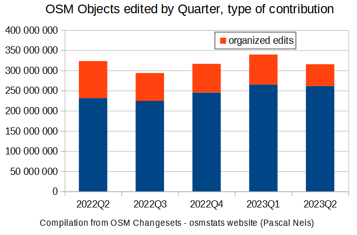
Here is a brief analysis of trends in OSM edits and spatial distribution using compiled statistics from Pascal Neis osmstats website. The link at the bottom of the page will let you download the csv data (by month, quarter / country, region, continent) and make your own analysis.

Thanks to Pascal who provides such usefull infos about OSM activities. As Organized editing statistics have been added to the osmstas website at the beginning of 2022, we will cover the periods from 2022-04 to to 2023-06.

As illustrated on graph 1, there was a small decline of OSM objects edited during this period from 323 millions objects edited in 2022-Q2 to 314 millions in 2023-Q2. This decline comes from the Organized editing with 92 millions objects edited in 2022-Q2 to 54 millions in 2023-Q2 (his share from 28% to 17%).

Graph 1 Graph 1

See full entry

Location: 0.000, 0.000
Posted by TrickyFoxy on 21 August 2023 in English.

To start editing OSM, a new user needs to go through a cluttered registration form.

At the same time, vandals easily register thousands of new accounts.


One vandal with an army of bots can paralyze the work of hundreds of mappers in an instant.

At the same time, only the gradual careful work of one person can correctly correct a damaged map.


The project is 19 years old, it’s time to grow up.

Hi all, I’ve made a website which shows how all the waterways in OSM are topologically connected, or not:

OSM River Basins

More details are there, or on the backing github project. You can also run the programmes for yourself if you want to tweak it, or just show your region.

This tool can help you find possible tagging mistakes in river topology, like change in a name, or find places where 2 rivers aren’t properly connected up.

Data is updated manually by me when I remember.

What do yous think?

You can follow me on fedi/mastodon @amapanda@en.osm.town for news, or read this on the Discourse OSM Community Forum