
I have just realised I should have been adding ‘survey’ as a source in basically all my edits over the last week or so.
I’ve been using RapidEditor to create buildings, matching them with my notes as I walk around exploring my new neighbourhood.
🤦
 OpenStreetMap
I have just realised I should have been adding ‘survey’ as a source in basically all my edits over the last week or so.
I’ve been using RapidEditor to create buildings, matching them with my notes as I walk around exploring my new neighbourhood.
🤦
If you’re not aware, a massive number of accounts have started removing name:ru tags from objects worldwide. Over 4,600 accounts have already been blocked as of the time of writing. I want to bring this situation to the attention of the OSM community that might not use the community forum/discord/etc. and doesn’t know what’s going on.
I don’t really know what to say about this situation or a solution, but it hasn’t been mentioned on-site yet. I hope OSM finds some way to deal with mass-account vandals because mass blocks + detection don’t seem like a sustainable solution, especially with changeset comment abuse, notes abuse, private messages abuse, etc. - the fact that this could happen in the first place is problematic.
(from OSM Discord)

(from OSM Discord)
We are lucky this person is “only” removing Russian names, not something more critical
-snoozingnewt
After an unfortunate setback in 2020 the 14th in-person State of the Map conference will be held in Africa for the first time, underlining OSM’s status as a truly global map. Long may our commitment to going round the world to experience what we are mapping continue.
I’ve never heard complaints from the many people who attended Foss4g and the HOT summit in Dar es Salaam and I am confident that Nairobi can be a similar success.
This diary is about how the Divide and map. Now. is deployed.
Divide and map. Now. consists of multiple parts like server, JavaScript clients, JOSM plugin or web page. Each part is clearly separated and has its own repository. All are integrated within the damn-deploy, which has its own repository, too.
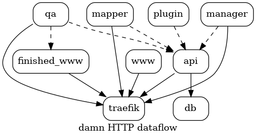
I am not a sysadmin. When I worked on the refactor deploy, I kept Docker and Systemd and Debian. I simplified dockerfiles, removed unnecessary ones, removed unused SQL code, added systemd units and rewrote the “How to deploy” and “How to upgrade” in the README.
I added damn-www-template with the hugo static site generator, simple blogging theme and an example content. If you care to run your own instance, you may get inspired. But don’t get limited – only a dockerfile serving your web page is expected.
Over the past few days, my perspective on OpenStreetMap (OSM) has undergone a seismic shift. For the longest time, I held OSM in the highest regard, viewing it as a beacon of transparency and people-centricity amidst a sea of profit-driven tech conglomerates.
My view started to waver a couple of days ago when a new donation request banner popped up on the main OSM page. Though its sheer size and prominence were unsettling, the real issue lay in the near-invisible close button. When I voiced concerns on its ready-for-production state, opposition awaited me on the other end. Was this a shift in OSM’s priorities?

This entry was meant to test this Diary feature.
Sorry for the clutter.
Hello everyone, I am here again with the 5th Blog of my journey as an Outreachy intern. For those who don’t know me , I am Neelima Mohanty , selected as an Outreachy intern at Humanitarian OpenStreetMap Team (HOTOSM) for the May to August Cohort. If you are new to my blog then make sure you read my previous Outreachy Blogs before going through this blog post.
This is the second last week of my Outreachy internship and I almost feel like I am a part of the HOT Community or in other words I feel like I know many members of HOT already. Apart from my mentors Rob Savoye and Petya Kangalova , the list of members whom I know are Kshitij Raj Sharma , Omran Najjar , Susmina Manandhar and Sam Woodcock . Informal chats with all these people made me more familiar with this community. Let me introduce all of them with you and what I have learnt from the informal chats with them.
Kshitij and Omran are part of the dev team for fAIr project of HOT . I learnt a lot from each one of them about backend and frontend of that project and understood their work to implement AI in the process of mapping .
I already have written about my interaction with Sam Woodcock in my 2nd Blog . But that was how we came to know each other for the first time . Whereas when I got selected as an Intern , he sent me a message introducing himself and told me that he would like to help me in my technical documentation work in FMTM if I face any issues . Then I came to know that he had been volunteering for FMTM since a long time.
And finally and very recently I met with Susmina Manandhar from Nepal who work as an Associate Project Manager at NAXA one of the partners of HOT . We together worked for two weeks and prepared the Lightning Talk Video of the FMTM project for Code for All summit. While in these two weeks , we met almost everyday and not just talked about work but she also shared about herself and her University days .
I had mapped my first mass path a little over two years ago and made a video about it: https://www.youtube.com/watch?v=JyxYRqNG6aI. I’m revisiting the topic now for reasons I will get into.
In Ireland, mass paths are either footpaths people used to walk to church or - more often - to school (because the school tended to be very close to the church). Those mass paths are basically short cuts across fields and were used until the 1960s or thereabouts. The other type of mass path dates back to the times of the Penal Laws, when Catholics were forbidden to go to mass (and to school). They met at secret locations, mass rocks or mass pits, to celebrate mass. The went out of use with the end of the Penal Laws.
My local county council had wanted to start a project to record mass paths in the county, and I considered applying for it, but I could not meet their conditions (driver’s license, insurance). This was regrettable, because I could have assembled the perfect team, but it was not possible for us. However, thanks to determination and OpenData platforms like OSM and Wikimedia, it doesn’t mean we can’t record some of them.
Today I spent half the day in the forest near Bahrdorf to prepare an orienteering map in OOMapper. First I downloaded the OSM data into the app, then set out with a tablet computer as well as fieldpaper, pencil and compass to add all the features necessary for orienteering. There are of course lots of details to attend to, but I want to write about the role of OSM in orienteering mapping today.
For a forest map that I set up from scratch, OSM data come in handy because they provide a georeferenced basemap to start from. But other than that, 99% of the orienteering map is my work, and there is not much in what I do that is of interest for OSM (except the odd information board or a path that has disappeared).
Things are quite different when it comes to sprint orienteering maps, which mostly show parks and urban areas. The availability of OSM data was a real game changer here, because we used to draw all the building outlines by hand. For a quick training map, there is a webservice that renders OSM data in an orienteering map design and lets you download the map as a nicely styled pdf. Of course, this map will only contain the features that are present in OSM and cannot be edited further, so I still prefer to use the OOMapper app with downloaded OSM data, so I can add whatever features I need for the orienteering map - and more than a few of them will also be useful in OpenStreetMap.
The biggest question here is: do I add the features after downloading from OSM, or before? One the one hand, since OSM data helped save such a lot of time, it seemed only fair to give back. Moreover, if all orienteering features of a specific area were present in OSM, I wouldn’t have to bother about map backups, and every interested orienteer could download a decent o-map from the webservice mentioned above.
So this is what I brought me to OSM. Needless to say, today I spend far more time on OSM mapping than on mapping for orienteering.
North America has a lot of streets that go “straight north and south”.
This presents a difficulty because once a road’s azimuth goes left of due north, its labels must flip to avoid becoming upside down (as the street continues curving.)
This is not usually a problem with straight parallel streets, as all will be left or right of due north, thus their labels will all either read all upwards or all downwards.
So why do the labels on Brown Avenue, in Evanston, IL USA flip back and forth, disturbingly different than its neighboring fellow north-south streets? (See osm.org/way/23392043 and inspect its avenue name at different zoom levels.)
Ah ha, because it wavers sightly back and forth over true north! Let’s check those azimuths as we go along it:
wget https://www.openstreetmap.org/api/0.6/way/23392043/full
perl -F\" -awnle 'next unless $#F==18; print "@F[-2,-4]"' full |
  sort -k 2n | gmt mapproject -Aof -o2
NaN
1.34312351808
1.4347131823
0.581553728998
-0.40040076319
-0.406099373288
0.930238524534
0.595013044226
1.17968994378
Anyway, “you got to draw the line somewhere” for when to flip lettering, so it’s at true north. Adding some “AI fuzz factor” would probably just complicate algorithms.
What’s this for?
~~~This blog is also posted on my Medium account here ~~~
We often talk about how OpenStreetMap contributes to various initiatives like disaster responses, urban planning, land use analysis, and research. However, I believe we’re not doing justice to OSM by not sharing how it has profoundly impacted our personal lives. As OSM celebrates its 19th birthday, I’d like to offer my story as a birthday gift — a glimpse into how OSM has transformed me. I hope you find my journey an enjoyable read!
I became a part of OSM in 2015, just a few days after completing my final university examination. To be honest, I joined because I found myself with time on my hands, waiting to secure a job opportunity. Little did I know that this decision would mark the beginning of a transformative journey.
I got introduced to OSM by Geoffrey Kateregga, when the Ramani Huria, (Swahili for Open Map) a HOT-led project was kicking off in Tanzania. The project involved over 150 students & fresh graduates from the University of Dar es Salaam and Ardhi University to map flood-prone areas of Dar es Salaam, and this is where OSM started transforming me!
I made my first map edit at the campus ground, and it sounds trivial but I was super excited after Geoffrey mentioned that, anyone in the entire world can be able to see what I mapped, validate and actually use that! Honestly, it’s that thrill that keeps me engaged with OSM even today — yes, it’s that powerful! haha.
I’m lucky sometimes to find something just like this. Uhhh. It was tough. https://osmcha.org/changesets/139739372
before
On the 9th of August 2023, I participated in the State of the Map Africa scholarship committee in reviewing the application submitted by members of OSM Africa for sponsorship to this year conference that to be held in Cameroun.
I thoroughly enjoyed my involvement with the FMTM testing team, where I gained invaluable experience in data collection within Shyira Sector, Nyabihu District, located in the picturesque western province of Rwanda. Working alongside a remarkable team from Rwanda, I was inspired by the diverse and enthusiastic individuals I had the pleasure of collaborating with. The Rwandan terrain, delectable cuisine, and engaging interactions with members of the HOT community left an indelible mark on my memory.

Resilience is the ability of a community to continue to live, function, develop and thrive after a crisis. Key elements of enhancing resilience include maximizing social cohesion, collaboration, empowerment, participation and consideration of local characteristics and issues. This means dialogue within, and inputs from, the community itself. Skilled volunteers within the community are then to take the responsibility to rebuild relationships — within the community, with the external stakeholder i.e. organizations, and governments, to revive the buzz again and again, where it was left behind. These relationships form a solid foundation on which other community volunteers can create positive change, by improving their skills and abilities for better contribution. Fresh thinking is also needed more than ever because volunteers have unique attributes that make them essential and put them at the heart of the restoration process.
Like most community-based resilience volunteering, volunteering with the OpenStreetMap community is also uniquely flexible. People from all backgrounds sign up to support a wide range of initiatives, activities & organizational efforts across social, economic, health, logistics, environmental development & humanitarian crisis response by enriching open & sharable geo-data repository through the OpenStreetMap platform. We know from experience that it works as a great support in every context and adds value to every type of program, from Disaster risk reduction & response, public health, protection, wash, education, information management & logistic support, by fueling evidence-based interventions. The approach is universal and adaptable nowadays; community capacity development, operation & program management, mentoring & leadership are the key components to strengthening & sustaining activism.
After giving the “How to become an OSM pro” talk at CCC last year, I will give two talks at CCCamp23 next week:
This covers what OSM is (not), why to map, where to map, what to map, and how to map. Perfect to get your friends started with OSM!
Introduction and examples of using the [Overpass Query Language](osm.wiki/Overpass_API/Overpass_QL) and [Overpass-Turbo](https://overpass-turbo.eu/) to fetch data from the OpenStreetMap database. Can be used for mapping, quality assurance, or research
Edit: There is an Overpass talk at CCCamp already, so I’ll do mine some other time.
The exact time is not yet announced, keep an eye on the (self-organized) schedule, or follow me @jomo@mstdn.io on Mastodon. See you at the camp!
In 2023, the project’s anniversary, OpenStreetMap’s 19th anniversary birthday party will be celebrated around August 9, 2023 in cities all over the world! osm.wiki/OpenStreetMap_19th_Anniversary_Birthday_party

https://tasks.hotosm.org/projects/15381/
The Openstreetmap 19th birthday party event will take place today at 8:00 pm with the Quississana neighborhood map, in the city of São José dos Pinhais, Paraná osm.org/relation/1123929#map=15/ -25.5504/-49.1532 where we will map the buildings that are missing in the neighborhood and we will also promote an online meeting of Brazilian mappers in the room of UMBRAOSM - Union of Brazilian Openstreetmap mappers at the link: https://meet.jit.si/ umbraosm
The Event will be promoted by UMBRAOSM - Union of Brazilian Openstreetmap Mappers
Festa de aniversário de 19 anos do OpenStreetMap.


