Diary Entries in English

Recent diary entries

One of the biggest things that’s annoyed me with OpenStreetMap is the pertinent lack of POIs, compared to the big G that many around me have generally accepted as the standard navigation app and database for everyday use. It actually made me excited for Overture Maps, as I thought we could easily take the good stuff from Facebook’s places data to improve our map.

When the Overture Maps Foundation’s data released its first alpha files, naturally, the OSM community started sleuthing in there. The job became even easier when community member @bdon released a tool to overlay the POI dataset into an OSM basemap, as seen here.

The way Meta sourced the POIs in the first place has unintended consequences, however, like…

Top 12 Beach Resorts inside Neighborhoods near Me

That heading would suffice for a top-ten listicle, haha.

I’ve manually listed a small sample of such hotels, resorts and other kinds of supposed accommodations that, for humans, “obviously don’t belong there”: first as screenshots one-by-one, and then add them all into a table.

1 — Water Park in Tract Housing

See full entry

Posted by GPS-GR on 8 August 2023 in English.

I asked my first question on the Support Forum. Member Minh Nguyễn was kind to answer it quickly and accurately. I wanted to add a speed limit to a Way but the Way was under a “Boundary” data label.. The solution: Select Edit.. Then on the RIGHT side of map area are icons. By selecting the one called “Map Data” and then clicking on heading called “MAP FEATURES” and then un-checking the box for “Boundaries” then the Map doesn’t display “Boundary Data” With that layer now hidden the WAY was easy to select and add Speed Limit Tags. The OSM ID Editor has many cool features once someone shows me.. :)

Posted by GPS-GR on 8 August 2023 in English.

Tonight I learned how to designate different Speed Limits on the same road going in different directions. The Forward direction of a “Way” has little guide triangle icons when a Way is selected that act like arrows. These triangle icons point in the Forward Direction. The reverse of Forward is Backward. After selecting a Way, there is a menu on left called TAG’s. I simply press add (+) to create a TAG called maxspeed:forward and maxspeed:backward and assign a speed limit appropriate for that section of Way. It doesn’t populate “mph” so I needed to remember to include that after the speed. I figured that out later and went back and double checked all my Forward and Backward speeds. I like best when a street has the same speed limit in both directions. However many primary streets have sections with different speed limit overlap. ID editor really has some cool features. :)

Posted by christopherius on 7 August 2023 in English.

Before I started mapping I didn’t think much about walkability. There are parts of the city that are hard to get to without a car.

Some streets don’t even have a sidewalk. Theres a chance that curbs have no ramp for wheelchair users. I will say though that the city is making things better.

A couple new walking paths were built along the two main roads. Near my house there was also work done to the roads and sidewalks. We now have ramps on the curbs!

Posted by dónal on 6 August 2023 in English.

It’s a long weekend this weekend in Ireland so I found some time today to catch up on some OpenStreetMap tasks.

Primary objective: Send welcome messages to new contributors in Ireland.

Objective status: Completed. \o/

Other observations:

  • new contributors add lots of good information. some mistakes but we also did that at the start.
  • lots of buildings still to add in Ireland.
  • impressed by the amount of organisations trying to contribute updates. Saw new contributions from libraries, public transport organisations, business improvement organisations.
  • A new contributor with a username that may signify they work in the waste industry has been adding information for new estates. Love it!
  • Terracing tool rocks! Added a whole estate in Blarney, Co. Cork in about an hour using it today.
  • Map Roulette (see maproulette.org ) is cool.

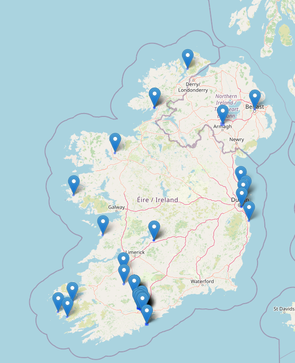
Map of recent edits for dónal

Map of Ireland showing openstreetmap edits by dónal

Location: Centre A ED, Cork, County Cork, Munster, Ireland

Yesterday which was the 5th of August, 2023 we ha our weekly mapathon. This holds every Saturday of every week. I trained our newbie from last week on how to use Maproulette and how to map road. Then I also opened a new account and trained a newbie yesterday on how to map. We had two newbies yesterday but I could only open an account for the other because our time was up. We all also had refreshments and had fun mapping. We were a total of 6.

Posted by stephnwakonobi on 6 August 2023 in English.

I attended the monthly coordination meeting that took place on the 5th August from 9:45am-11am. The Agenda for the meeting 1. Map Nigeria Mapathon Project -progress and concerns 2. Other community Activities- 3. Reports from Mapathon centers/State Chapters/Campus Team 4. SotM Nigeria 2023-updates and Actions required

I also invited 2 persons to attend the meeting. It was quite nice.

Posted by SomeoneElse on 6 August 2023 in English. Last updated on 8 March 2026.

There’s lots of software around to work with OpenStreetMap data - querying it, creating maps from it, using it for navigation. One area that there has historically been less support is analysing OSM changeset data. As an example, here is one of mine.

However, many years ago Toby Murray wrote ChangesetMD. That can be used to maintain a database of changeset information (tags, discussions, etc.). Martijn van Exel updated that to a recent version of Python and I made a couple more changes to support very recent Python versions and made the replication more scriptable.

Downloading changeset data

Over on the planet.osm.org site, there’s a download for all the changeets generated at the same time as the weekly “planet” file is created, and also one for all the changeets and discussions as well. The changesets-only one is just over 6GB (bzipped), and the one with discussions as well is only about 250MB more, because most changesets don’t have discussions.

If you’re not interested in changeset data dating back to 2012 you don’t need to download this file; you can just start replicating from whatever point in the past you are intereted in starting from.

Installing the software

If you’re on Debian or Ubuntu, you’ll likely want to follow these instructions from a non-root user account of your choice (substitute that account for “youruseraccount” in the instructions).

Running it for the first time

From the virtual account created by the installation, which you can reenter by running

cd /home/${youruseraccount}/src/ChangesetMD
source .venv/bin/activate

Run something like this

python changesetmd.py -d changesets -c -g

The “-g” is optional and initialises the database to store geometric data. “changesets” in the line above is just the database name.

Loading a changeset dump file

To load the database with changesets and discussions:

python changesetmd.py -d changesets -g  -f ~/data/discussions-latest.osm.bz2

See full entry

Location: Charlesworth, Gamesley, High Peak, Derbyshire, East Midlands, England, United Kingdom
Posted by fudoreaper on 4 August 2023 in English.

Editied OSM again this week.

I’ve spent time at Sargent Park (Winnipeg, Canada), and noticed a lot of missing pathways, which I can use on a bike or walking. I’ve made several updates to paths, roads, parking, fences, building names, facility names, etc.

I’m quite happy with the changes.

I haven’t found a good android app for OSM, either. Someone must know something decent– a kind of google maps competitor.

Location: Portage & Main, St. Boniface, Downtown, Winnipeg, Manitoba, Canada
Posted by 38446 on 4 August 2023 in English. Last updated on 5 August 2023.

Today I came to think again about on-demand bus service areas. There is one mention on the OSM wiki: this explanation from Belgium, but I’m not sure if it really refers to a service area rather than a line with on-demand stops. The idea of the on-demand bus service area is that from one central stop a small bus will take you wherever you want to go, almost like a taxi, but only at certain times, and together with other passengers (if there are any). The concept has been quite common for some time in rural areas all over Europe. In my opinion, we could just draw the area, give it some tag so it is put down in the data that this rural area is generally accessible by public transport.

Mapper BroccoliB did so here, and his attempt was also what made me think about it again.

The reason I came across his edit was that my wife and I had a day off and used it for a bike ride through the sparsely-populated area north-east of Wolfsburg, just across the former border between West and East Germany. It was nice cycling along the Mittellandkanal - but I have to say that we are quite used to gravel tracks and have equipped our bikes with appropriate puncture-safe tyres. Some excellent pear trees along the road here. No traffic at all because of a road closure further south. When we came to the nearest larger village, we had to decide if we wanted to continue on the road in heavier traffic now or use a track running parallel. To our surprise (it wasn’t mapped as such yet), it had excellently smooth asphalt. For the way back we had opted for a bus line that also carries up to five bicycles (for free!). It’s really amazing what the land of Saxony-Anhalt with its limited resources and sparse population does for an attractive public transport. Lower Saxony could take a page from its book!

Location: Klötze, Altmarkkreis Salzwedel, Saxony-Anhalt, 38486, Germany
Posted by NorthCrab on 3 August 2023 in English. Last updated on 15 August 2023.

🗺️🦀 Hello OpenStreetMap community,

I am excited to share with you my latest invention, osm-yolo-crossings — a new tool that harnesses cutting-edge AI technology to autonomously detect and map pedestrian crossings (zebras) in OpenStreetMap. After the successful AI building import in Poland, it’s now time to expand and improve pedestrian safety!

Application banner

Leveraging the power of YOLOv8 object detection, this tool is designed to ensure that we no longer miss pedestrian crossings on our maps. With an impressive >99.7% precision rate, it’s able to import around 88% of all detected crossings. The tool discards the remaining 12% due to low confidence levels. Thanks to smart filtering, this system is incredibly efficient. For instance, it can map the entirety of Poland in just about two months using a single server without GPU. This is AI working smart, not hard!

See an example changeset.

See full entry

With the new release of more than 59 million points of interest (POIs) from Overture, consisting of Microsoft and Meta POI datasets combined, the natural question arises: how can this be useful for OpenStreetMap?

Challenges to consider

The most important challenge in getting this data into OSM is making sure the place labels in Overture have an equivalent in OSM. This is mostly doable with automation, but many cases require context.

Validation of these is a forthcoming challenge: street-level imagery from Mapillary will be especially helpful, but being there in person to validate is also a big advantage. That aside, even if the data can be added to OSM one-by-one (not imported) with validation, the tags need to have a proper format.

Loading up the data to analyze

I got started by referencing Feye Andal’s great and succinct guide on viewing the data in AWS Athena. I found a slight lack of clarity in the instructions: you need to make sure your Athena instance, and your S3 bucket where queries are saved, are on us-west-2 region, same as the Overture dataset, unless you copy the dataset first to a bucket in your other region. So make sure the regions are the same, and the instructions should work flawlessly!

Analyzing the data

Exploring the dataset, there are 1037 unique place labels in it. 86,000+ are structure_and_geography which can refer to a wide range of natural geography or built structures in OSM, difficult to match with any specific tag without context. Others translate directly, such as a laundromat.

Some example tags include: "forest", "stadium_arena", "farm", "professional_services", "baptist_church", "park", "print_media", "spas", "passport_and_visa_services", "restaurant", "dentist"

To get most of the tags matched, I used Python to import the OpenAI module, and connect to my OpenAI account, which charges a few fractions of a penny per request.

I set a system message, which defines the role the AI should play or assume. My message was:

See full entry

Location: 47.049, 8.547
Posted by TrickyFoxy on 2 August 2023 in English. Last updated on 3 August 2023.

It seems that there is only one instruction for getting fresh Sentinel-2. It tells you quite well how to prepare images, but it is difficult to explain how to use them in OSM editors. So after step 7, you can do

without GeoTIFF and tile server

  1. Select in QGIS: Processing->Toolbox->Raster Tools->Generate XYZ tiles (MBTiles)
  2. Set the parameters:
    • to Extent of the map area you need.
    • Maximum Zoom is most likely 15.
    • In Output Path, specify where to save the tile file
  3. Click Run and wait for rendering to finish.
  4. Install the mbtiles plugin in JOSM
  5. Open the file you received in step 3.

By the way, recently Guru Maps learned how to tear off MBtiles https://gurumaps.app/blog/2023/06/14/mbtiles


But if you still want a tile server, you can do without tileserver-php from the instructions. And without the QTiles plugin, it will also work faster!

Classic tiles with a web server

  1. Select in QGIS: Processing->Toolbox->Raster Tools->Generate XYZ tiles (Directory)
  2. Set the parameters:
    • to Extent of the map area you need.
    • Maximum Zoom is most likely 15.
    • Set Output Directory. You can immediately select the directory of your web server.
  3. Click Run and wait for rendering to finish.
  4. Start your web server. If you didn’t use Nginx or Apache, open the folder with your tiles in the terminal and try using the web server in Python: python -m http.server 80 or PHP: php -S 127.0.0.1:80
  5. In JOSM, open Preferences->Layers->+TMS
  6. Enter a URL like this: http://localhost/<tile folder name>/{zoom}/{x}/{y}.png
  7. Get closer to the desired area in JOSM and select your new layer from the Layers menu.

p. s. I used QGIS 3.32.1-Lima.


upd: method from @maraf24

Classic tiles for JOSM without a web server

Instead of starting the web server, specify the following URL in JOSM: file://<absolute path to the folder with tiles>/{zoom}/{x}/{y}.png