 OpenStreetMap

Aida
Diary Entries in English
Recent diary entries

The OSM Urban Road classification guidelines for India dictate a number of high-level directions on mapping roads in Indian cities. When Devdatta and I tried to fix some classifications in Pune, we realised that the current guidelines don’t provide a solid base for decision making, in an “if X, then Y” way. So we decided to observe, annotate, experiment and retrospect on whether a classification makes sense.
We realised that to map a road, one must understand how a road is perceived, and its purpose in the larger scope of the neighbourhood, locality or city. This gives the road a purpose, and that purpose defines its classification. The purpose or intent of the road is not enough to classify it, so we tried to observe a few other factors that characterise roads in major Indian cities. Here’s what we found.
- Much like a river, a road begins somewhere and merges into another road. As roads connect with each other, the larger road essentially “collects” traffic from a smaller road. However, it is not necessary that a smaller road feeds into a larger road. Often, it might feed into a road of the same size, but with elevated purpose.
- Some roads serve the same purpose but could vary wildly in their characteristics, including the width of a single lane.
- Many collector roads can be easily identified using tell-tale signs such as the presence of speed bumps, traffic signals and dividers.
The observations led us to try and categorise roads based on a few factors:

We know from the pilot HOT unSummit programme that we need a better name (too many people thought it referred to the United Nations!)
Can you help us think of one?

It need to encapsulate one, some or all of the following aspects…
- It is a programme that supports / collaborates on open mapping-relevant events all over the world
- The objective is to inspire people and give them the means to take collective action on humanitarian / social problems through open mapping and OpenStreetMap
- It seeks to expand and strengthen the humanitarian open mapping movement
- It is supported by / powered by HOT, but in collaboration with many communities and organising committees
Once we have a new name, we will update the branding and the next phase of the programme will relaunch in June.

Let’s recap some work done on the damn project.
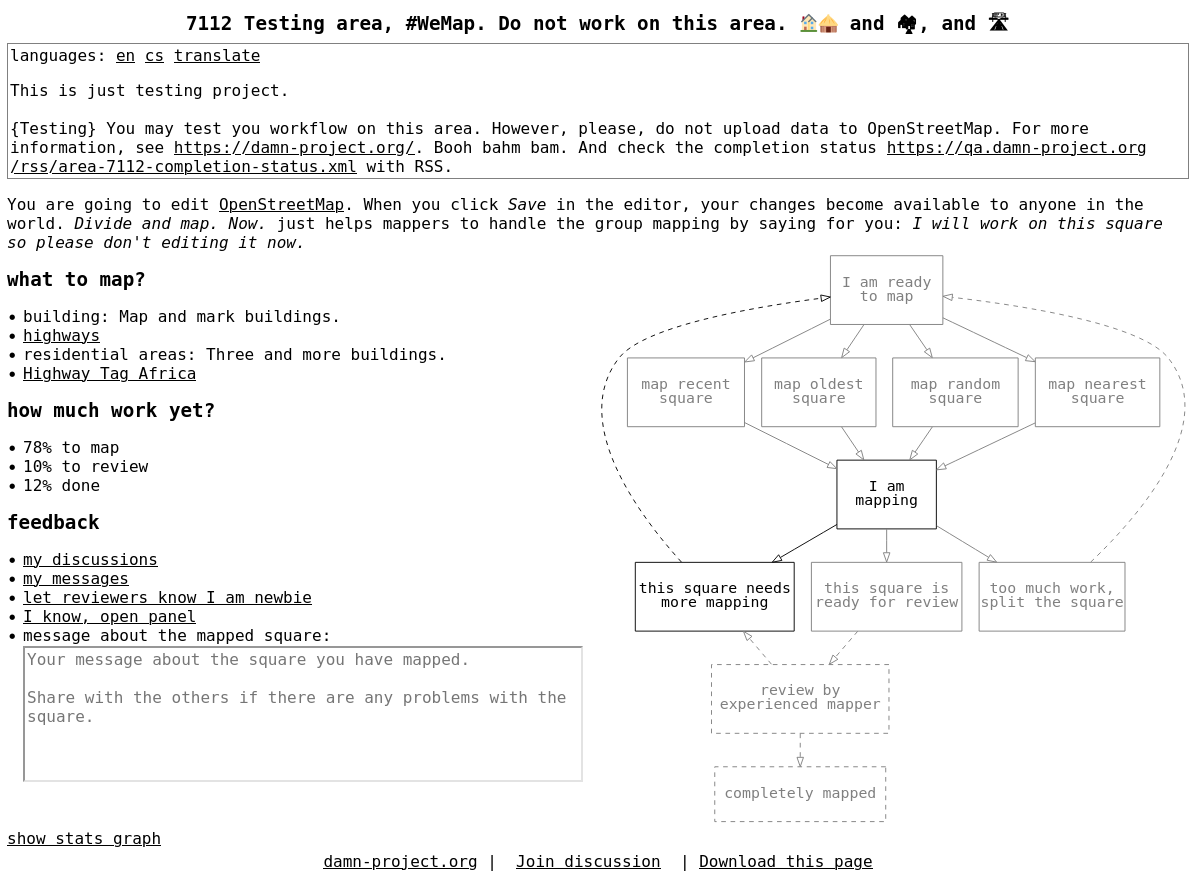
Divide and map. Now. – the damn project – helps mappers by dividing a big area into smaller squares that people can map together.
As outlined in Work for 2023, I have been working on the improvements to the web clients. The consequences are better clients and easier deployment (which is not yet documented). Also, I have restructured and slightly rewrote the https://damn-project.org/ web page.
Changes to the web clients
New client for beginner mappers is out, see
mapper. I was thinking of how to better
describe map-review-done
workflow. The original client has “Show mapping square workflow
diagram” showing ASCII art square’s state flow when clicked. I had and
idea to show SVG figure (generated by dot) instead of ASCII art,
because it is easier to generate, maintain, and translate. SVG is text,
too, so I can bare that. But wait! SVG is HTML element, isn’t it? So
it’s clickable, isn’t it? So it can be done interactive, can’t be?

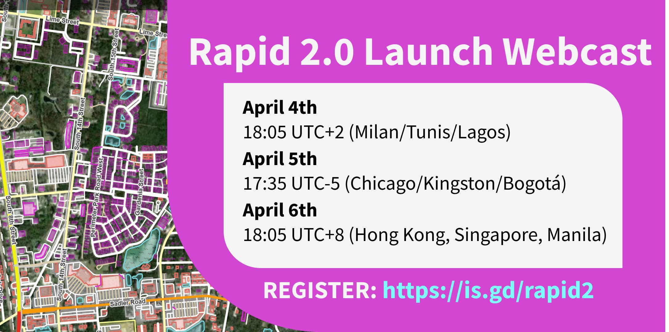
Rapid 2.0 launches this week. The Rapid team will host webcasts on April 4 (tomorrow at the time of writing), April 5, and April 6 for Europe / Africa, the Americas, and Asia / Pacific timezones respectively. You can sign up here. You can expect an overview of what’s new, and a live demo. You will also be able to ask the Rapid team questions.
What’s new
I wrote about the public beta of Rapid 2.0 before, and covered what’s new there.
One additional thing I wanted to call out is the ever-growing amount of external datasets available to mappers for efficient mapping of addresses, buildings and other features available as open data. There is a page on the OSM wiki that lists them all, and Esri has an interactive map with all the data sources available and considered as Rapid layers.
Posted by chris_debian on 3 April 2023 in English.
Last updated on 4 April 2023.

Ok, following on from my earlier writing, I can confirm that I have installed and tried capturing data with both the SmartRoadSense and Roadroid Android applications, on my Pixel 6. Both apps had good points, and ‘areas for development’. I was only able to capture data, submit it, and see it on a map, with Roadroid. My understanding is that I can’t do this with SmartRoadSense, because the app infrastructure is currently dormant, due to EU funding coming to an end, but I understand from the devs, that they are about to reinvigorate the project.
Lars Forslof (Roadroid) is doing some excellent work with his propriety solution, but I think the nature of his objectives, are business oriented, and enables a ‘customer’ to request survey coverage for a defined area, which is then coordinated, at a financial cost.
My main questions/ thoughts now, are:
- Is road surface data useful to anyone? I would suggest it is useful for deciding on routing, and can be used under open source terms, to enable interested bodies, such as highway/ local authorities to have an initial understanding of where surfaces don’t meet a required standard.
- Is OSM the right place to record the values?
- Can the open source community encourage the good people at SmartRoadSense to work with us, or do we need to create a new app, with infrastructure? The algorithm used to process the data is currently closed source. My preference would be to work with SmartRoadSense, and have a backlog of potential improvements, hosted on GitHub https://github.com/SmartRoadSense
- Encourage interested users to install the SmartRoadSense APK, and to give feedback at the GitHub address. The app didn’t appear in Play Store, in the UK on a Pixel 6, so I’ve used APK https://m.apkpure.com/smartroadsense/it.uniurb.smartroadsense
- I will write to the SmartRoadSense devs, to highlight these thoughts.
What is needed (Requirements capture)? (MoSCoW)
M= Must Have S= Should Have C= Could Have W= Won’t Have

OSM supports really complex opening times, apparently.
This node, a roof-top bar in Stratford, London is opening on the 20th of April. The following are the opening times per their website:
- April 20th to April 30th : Thursdays to Fridays 5pm- 11pm, Saturdays-Sundays 12-11pm
- May 1st- May 14th: Wednesdays to Fridays 5pm- 11pm, Saturdays-Sundays 12-11pm, Bank Holidays 12-11pm
- May 15th- end of September: Tuesdays to Fridays 5pm- 11pm, Saturdays-Sundays 12-11pm, Bank Holidays 12-11pm
The opening_time value I came up with is this:
Apr 20-30 Sa-Su 12:00-23:00; May-Sep Sa-Su 12:00-23:00; Apr 20-30 Th-Fr 17:00-23:00; May 01-14 We-Fr 17:00-23:00; May 15-31 Tu-Fr 17:00-23:00; Jun-Sep Tu-Fr 17:00-23:00; Oct-Dec off; Apr 20-30 PH 12:00-23:00; May-Sep PH 12:00-23:00
It also helped that there exists a handy tool that can visualise complex opening_time values.
I am looking forward to seeing how OSMAnd handles this when it eventually gets the updated node.

Hi all! I’m writing this new post to show a recent mapping that I’ve done on an industrial facility. In this case, I worked on a crucial headquarters of Petronas International, located near Turin (between the municipality of Santena and Villastellone).
The facility has been in that place for a long time but in the recent year the company built here the new global research centre so, under the pretext to add the new building, I mapped with care the facility.
That the result of my work:
Before

After
Posted by ngumenawesamson on 2 April 2023 in English.

To support organizations that use OpenStreetMap data for disaster response, the HOT Data Team is strengthening our data quality and fitness measures.
Several teams at HOT, including the Data Team, Technology & Innovation Team, and the Regional Hubs, are collaborating to develop resources, tools, skill sharing, and community feedback mechanisms that will be avenues for data creators and data users to collaborate to improve OpenStreetMap data quality.
Data Team:
The HOT Data Team presented the top 10 data quality issues in a lightning talk at State of the Map 2022 in Florence. We categorize these data quality issues into three main categories:
Semantic Accuracy
- Tagging
- Tasking Manager project consistencies
Positional Accuracy
- Spatial offsets
- Feature tracing inconsistencies
- Logical consistencies of map features
Completeness
- Temporal inconsistencies
- Road network inconsistencies
- Completeness of health facilities
- Completeness of public service data for sustainable communities
- Administrative boundaries
The Data Team is also defining use cases and data quality metrics. Measuring data quality starts with identifying core datasets for each of our impact areas. Examples include highways and health facilities for Public Health, water & sanitation, transportation, and education for Sustainable Cities & Communities, and waterways, buildings, and highways for Disasters & Climate Resilience.
We then evaluated the use cases and the metrics for assessing the quality of each dataset, enabling us to identify ways of improving data quality.
Technology & Innovation Team:
Technology & Innovation Team is implementing automated tools for measuring OpenStreetMap data quality.
Posted by frozenrabi on 2 April 2023 in English.

Lately I’ve been going for field survey day in day out. These day I spend most of my time on field survey using maps for field verification, collection of Point of interest (POI) data, land use zoning and obviously for public participatory mapping. Since 2018, there is no day that I had not worked or engaged with map. After I was introduced to this beautiful and addictive OpenStreetMap (OSM), I became a consistent OSM Mapper and a volunteer. While looking back, I felt I made right choice engaging in the field of OSM. From beginner curious mapper to Humanitarian OpenStreetMap Team (HOTOSM) Global Validator & being HOTOSM & OpenStreetMap Foundation(OSMF) Voting member, I’ve came a long way.
.jpeg)
Upon attempting to upload a new changeset, I received an error on iD. I don’t know what it means but it has an error code of 400 so it should be a server issue. Does anyone know what to do here? Will I have to start over?
I tried looking through the Help page but it’s hard to find what I’m looking for.
Posted by Jan Olieslagers on 1 April 2023 in English.
Last updated on 10 April 2023.
I think I am not the only one to find this matter confusing. The one clear and authoritative source of information is a pdf, in Russian language and Cyrillic alphabet only: http://www.caiga.ru/DocAni/manual_of_4_letter_indexes/Indexes_of_Airports.pdf ; it is regularly updated.
There are three columns of codes:
-
local “civilian” code, usually beginning with ‘У’, which transcribes to U
-
local code for “state” airfield, which includes military terrains, codes usually begin with a ‘Ь’ character, which transcribes to ‘X’
-
“international” code, given in Latin alphabet, corresponds to ICAO
Aerodromes of mixed military/civilian use will have the first and second columns filled out; or, if they have international status, all three. UHSS Yuzhno-Sakhalinsk is an example.
Thanks to mapper Mazda05 for patiently explaining!
PS local_ref beginning with Z or H are not official, they seem to be empirically assigned by maps.aopa.ru (which I often consult, though its information is not always perfect). Better an unofficial ref than none at all, in my opinion.

I’ve released a new version of tilemaker, the command-line utility that takes OpenStreetMap data in .osm.pbf format and makes vector tiles out of it.
It’s now between 45% and 85% faster - you’ll notice the difference particularly in places with complex multipolygon geometries. Memory usage is reduced, particularly in the polar regions. Plus it’s compatible with Geofabrik’s new CC0 “Shortbread” schema for vector tiles.

Yes, I am..i love Geography and Locations.. I churned whole Globe and used GPS from Day1
Posted by Kai Johnson on 30 March 2023 in English.
Last updated on 30 April 2026.
The GNIS matching project I’ve been working on uses a lot of Overpass queries to find things in OSM. At some point during the project, I needed a faster, more reliable Overpass server than the public servers. So I built a local Overpass server as cheaply as I could. It’s working well. This is how you can build one for yourself.
Update
Things have changed a lot in the last couple of years. If you’re just arriving at this diary entry, you might check out the newer container build for Overpass. Otherwise, keep reading …
Why Would I Build My Own Overpass Server?
If you’re using the Overpass API for software development, you’re going to be running a lot of queries. You could use a public Overpass instance, but it’s more polite and a lot more efficient to run one locally. Also, public overpass servers have query limits that you may not like. And sometimes they go down or flake out, and then there’s nothing you can do but wait until the operators fix them. If you run your own server, your fate is in your own hands!
For most use cases, a cheap local Overpass server can be significantly faster than using one of the public Overpass servers. The setup described here is a lot smaller with a lot less computing power than those big public servers. But it doesn’t have the entire world hammering on it constantly. Also, Overpass queries can return huge amounts of data. The network latency and throughput is a lot better on your own local network segment than if you’re downloading results from halfway across the world.
I’d like to give a special thanks to Kumi Systems for hosting the public Overpass server that I abused until I set up my own server. They’re providing a great service for the OSM community!
Do I Really Want to Do This?
Posted by umbraosmbr on 30 March 2023 in English.

Projetos disponiveis no maproulette.
DESAFIOS Procurar
Correção de CEP na Região Nordeste do Brasil para o Padrão Brasileiro = XXXXX-XXX / Correction of CEP in the Northeast Region of Brazil for the Brazilian Standard = XXXXX-XXX umbraosmbr’s Project
Correção de Nomes de Rua que foi mapeado de forma errada em todo Brasil. / Correction of Street Names that were mapped wrongly throughout Brazil. Raphaelkaart’s Project
Correção de CEP para o Formato usado no Brasil - Estado de Pernambuco. / Correction of ZIP Code for the Format used in Brazil - State of Pernambuco. Raphaelkaart’s Project
Correção de CEP para o Formato usado no Brasil - Estado da Paraiba. / Correction of ZIP Code for the Format used in Brazil - State of Paraiba. Raphaelkaart’s Project
Correção de CEP para o Formato usado no Brasil - Estado da Bahia. / Correction of ZIP Code for the Format used in Brazil - State of Bahia. Raphaelkaart’s Project
Inclusão de Nomes de Rua em Vilarejo Ponte Branca no estado de Goías - Brasil / Inclusion of Street Names in Vilarejo Ponte Branca in the state of Goias - Brazil. Raphaelkaart’s Project
Correção de Nomes de Rua em todo Brasil / Correction of Street Names throughout Brazil Brasil - Projetos da UMBRAOSM - União dos Mapeadores Brasileiros do Openstreetmap
Correção de Nomes de Rua em todo Brasil - Part1. / Correction of Street Names throughout Brazil - Part.1 Brasil - Projetos da UMBRAOSM - União dos Mapeadores Brasileiros do Openstreetmap
Correção de Nomes de Rua em todo Brasil - Part2. / Correction of Street Names throughout Brazil - Part.2 Brasil - Projetos da UMBRAOSM - União dos Mapeadores Brasileiros do Openstreetmap

This article is also available in Taiwanese Hokkien / Taigi (台文)

Taiwan is quite a hot topic in the news and geo-political discussion. Recently I read an thead discussing defense plans in the southern part of Pingtong by Taiwan Infantry Command officers on Taiwan BBS PTT military board.
Even though maps are blurred due to the detailed map might have some sensitive military information, it can easily be recognized by the green forest area, that the based maps they use are actually OpenStreetMap. Thanks to the hard-working OpenStreetMap mappers that keep drawing forests in Taiwan.

I asked ChatGPT to create an OpenStreetMap Community Building Playbook, this is what it came up with

Introduction
OpenStreetMap (OSM) is an open-source project that relies on the contributions of volunteers to create and maintain a free and editable map of the world. To build a strong OSM community, it is important to create a framework that promotes engagement, inclusivity, and collaboration. This playbook outlines key strategies for community building that can help OSM communities thrive.
Define your community’s vision:
The first step to building a strong OSM community is to define your community’s vision. What is your community’s mission? What are your goals and objectives? What values do you want to promote? Clarifying these key elements of your community’s identity will help you attract like-minded individuals and organizations.
Identify your community’s strengths and weaknesses:

As a first timer in Albay, I didn’t know what to expect from the Pista ng Mapa and State of the Map Asia 2022. However, as an OpenStreetMap (OSM) enthusiast, attending this event in person was something that I had always looked forward to. The opportunity to network with fellow OSM enthusiasts not just locally but internationally, connect with fellow youth mappers leaders around the Philippines, and travel with my students made this event a great experience.
The opportunity for networking was one of the highlights of the gathering. I had the opportunity to interact and get to know OSM followers from around the globe. Finding out about their exploits and how they used OSM in the various nations they hailed from. It was beneficial for me to be able to discuss ideas and pick up new skills from them.
The opportunity for student attendees to network with other youthmappers from different areas of the Philippines was another important aspect of the event. Meeting other young people who shared enthusiasm for mapping and were in charge of their own mapping initiatives in their various towns was wonderful. We were able to share our challenges, successes, and life lessons in addition to learning from one another.
It was a great bonus that I could go to the event with my students. They had a wonderful experience learning about OSM’s advantages and possible uses for their research and enhancing their own local communities. They had the opportunity to participate in a variety of lectures, workshops, and other activities that advanced their understanding of OSM and its possible uses.
The event was great overall, and the activities offered fascinating insights into the OSM communities around the globe. I appreciate the chance to participate, and I hope to have more opportunities like this in the future.
Posted by SomeoneElse on 25 March 2023 in English.
Last updated on 28 March 2023.
The new forum “community.osm.org” has been going for a while now, so maybe it’s useful to have a look at how things are going.
There’s obviously lots that goes into creating that forum as a site where people can share ideas - there’s the forum software itself, and the people looking after the technical administration of the site, the migration of the old forum (which has just happened) and the help site (planned for later), the various implementation decisions that got us to here, and also the people looking after content moderation (which is more actively managed than before). Of all of these, this diary entry is really only about the Discourse software itself.
I’ll not comment here about the future migration of https://help.openstreetmap.org/ to Discourse and the work required within Discourse to support that, since it would be unfair to judge something that has not happened yet.
Full disclosure - I’m one of the moderators of a couple of categories in the forum, but this is very much a personal view.
What’s good:
The software is actively maintained, unlike the old FluxBB forum software, or OSQA, which is used for the help site.
It’s working! Some communities that might have been a bit quiet or spread over private forums are now able to talk together much easier than before.
Searching works, with some caveats around the UI (see below for that). This may sound obvious, but mailing lists search at for example talk-gb can be a bit of a pain to use - a page such as this only shows the subject and the name of the poster, not the date of the message.
You can avoid “me too” answers (but see “reaction icons” below).
There’s a translate button on every post that supports the most common languages. This reduces the “echo chamber” effect that some forums had previously (and some other OSM channels still do now).