Diary Entries in English

Recent diary entries

English below

À l’ordre du jour de la prochaine réunion publique du Board de l’OSMF, le jeudi 30 mars 2023, il est prévu de statuer sur la demande d’utilisation du trademark OSM par la « Fédération des Pros d’OSM - FPOSM », une association française qui regroupe des professionnels et des entreprises travaillant autour d’OpenStreetMap. Cette demande est liée au fait que cette structure professionnelle (dont le site web est accessible ici) intègre OpenStreetMap dans son nom.

J’ai eu l’occasion de discuter avec certains membres de cette fédération et exposer également mon point de vue lors d’une réunion du Conseil d’administration de l’association OpenStreetMap France. Les réponses des membres de la Fédération peuvent se résumer à «  Nous pensons que c’est la meilleure manière de faire avancer les choses », mais sans avancer d’argument valable. Je pense que le nom de cette structure (et non ce qu’elle représente ou cherche à faire) constitue une erreur et une source élevée de risque à deux niveaux :

See full entry

Last March 4, 2023, the University of Science and Technology of Southern Philippines YouthMappers celebrated the Open Data Day 2023 with the theme “Empowering AI and Mapping with Open Data: A training-workshop on RapID”. We are very proud to have received a $500 grant from the Open Knowledge Foundation this year to organize Open Data Day 2023. With 40 participants, the training workshop was a tremendous success, and it was encouraging to see that more than half of the attendees were female. img1

Open Data Day is an annual celebration of open data all over the world. Groups from around the world create local events on the day where they will use open data in their communities. This year’s theme is “Open Data to AI”. With the theme “Open Data to AI” we aim to seek how open data is playing a critical role in the field of AI/ML and other emerging technologies.

See full entry

Location: 8.485, 124.657
Posted by PhysicsArmature on 22 March 2023 in English. Last updated on 2 May 2023.

Goal:

  1. Find a video on the OpenStreetMaps YouTube channel.
  2. Download the audio of a talk.
  3. Run it through OpenAI’s Whisper.
  4. Send the transcript and the source URL to somebody in the OSM Community who has ownership over the OSM YouTube channel.

While you may be able to automate this, I don’t know how to do so.

What you need:

  1. GPU (possibly NVIDIA, don’t know). 5gb vram (gpu ram). This might mean RTX 2060 or newer.
  2. Strong cooling and noise isolation through building design.

Costs

  1. Electricity will create some cost as transcription is hard. Do note that it is still less then the amount needed to power on and train a normal human being on the same task for several years in addition to the quantity of humans needed to get the same throughput.
  2. This will result in wear and tare on your drives and other components.
  3. This will make your computer and room warm in the summer. You need great cooling or the ability to use the excess heat for something valuable.

Steps:

  1. Install Itch.io to assist updating.
  2. Install whisper gui frontend by Grisk with Itch.
  3. Download audio from a talk (not saying how).
  4. Plug it in and get the result.
  5. Send the URL of the talk and the transcript to unknownPerson who runs the OSM YouTube Channel in a standard format.

Sample format for an email

Hello noun, This email is to submit a transcript.

talk: https://www.youtube.com/watch?v=nsaiHhQvNSY model: whisper medium

Disclaimers:

  1. I have yet to coordinate with anyone.
  2. Human transcript writers are great and needed. They are in short supply. Let us reduce the net demand. They can save their energy for high impact legal and medical environments.
  3. Maybe the built in YouTube transcript does the job well enough. This might not be worth the effort. I don’t know.
Location: Bloomington, Hennepin County, Minnesota, United States
Posted by b-unicycling on 21 March 2023 in English. Last updated on 18 May 2023.

About a fortnight ago, I went on a walk/ hike starting in the village of Tullahought, Ireland. There were two milk churn stands in the village which caught my eye, because they were restored and used as decorations and to tell the history of dairying in the area, on a small scale anyway. Tullahought milk churn stand, Author: A.-K. D., CC0 Wikicommons Tullahought milk churn stand, Author: A.-K. D., CC0 Wikicommons

Milk churn stands were used in Ireland (and elsewhere, of course) up to roughly the 1970s. The dairy farmer would leave their full milk churns on them, and someone from the creamery would do their round and pick them all up. They would return the empty churns or churns with skimmed milk in them, sometimes also leaving other purchases from the creamery like flour. It is possible that the milk man left smaller churns on the stands in other countries (judging from photographs of milk churn stands in other countries).

See full entry

Location: Pollrone, Tullahought, Tullaghought, The Municipal District of Callan — Thomastown, County Kilkenny, Leinster, Ireland
Posted by chris_debian on 21 March 2023 in English. Last updated on 22 March 2023.

What’s the problem (Bottom Line Up Front (BLUF))?

See my original post, here: https://community.openstreetmap.org/t/lidar-mapping-of-roads/97100/14

Hi, everybody!

Motivated by the state of roads in the UK, I’m wondering if anyone is aware of any Open Source/ crowdsourced efforts to assess the condition of surfaces, and then to map them?

I’m aware of lower cost LIDAR equipment, and I believe that some Apple phones have a LIDAR capability.

I’m thinking of something like Mapillary/ Kartaview. Sensor imagery could be gathered, and then scored appropriately, so severity could be seen. I’m thinking that a 100mm pothole on an unclassified and little used road/ lane, would potentially be of less interest/ lower priority than a 50mm pothole on a major motorway/ autobahn/ freeway.

Obviously, potholes are just one example, other immediate possibilities are subsidence, wear and tear, accident damage.

I’d be keen to hear any thoughts/ feedback. Please add to this page, if you can.

Many thanks, Chris chris_debian UK

What can we do about this?

Road damages create comfort-, environmental- and security problems. Existing measurement technologies are very expensive and can only be used rarely. With smartphones you can measure often or in remote areas.

Regarding ‘mapping potholes’, I expect this to be a layer applied to OSM, not data contained within OSM. It will be open source information, for people that can use it. My thinking being that OSM isn’t a repository for other data, but it can help us gather data, and we may be able to give back to OSM.

What has already been done, by whom?

SmartRoadSense info@smartroadsense.it (seems to be broken), github and APK

Roadroid map

See full entry

There is a really amazing video (Turkish with English subtitles) from Dr Uçum on the critical role that OpenStreetMap data has played in ensuring high quality public health programming in one of the tent cities for displaced people in Turkey as part of the earthquake response.

The video was originally published by Yer Cizenler.

Have also pasted below the English translation (thanks, once again, to Yer Cizenler) …

Well, hello everyone. I’m Doctor Mehmet Faruk Uçum.

I am the responsible physician in the largest tent city in Kahramanmaraş the KAFUM tent city. It is also known as New Ataturk Park and Kahramanmaraş Fairgrounds.

Here, as the responsible physician, I provide coordination in terms of health, we have set up the family health tent and we continue to vaccinate there. I also do public health work in the field.

During this process, with my friends in the OpenStreetMap community and my friends in Istanbul, we worked together and as a result of this work, we created a map.

I used this map especially during the vaccination process to find out which tent was where, because we really lacked data in this regard. We didn’t know the location of the tents, or which number was where, so we were not able to navigate to the right tents.

Recently again, I have used it to inspect and verify alleged scabies cases within the tents. I have, for example, some tent numbers that are said to have scabies but some of them may be seen wrongly or it is possible that the wrong number is given to us but I found them on the map and took the necessary action.

In public health, we used it again to identify outbreaks… the focus of outbreaks, that is. After marking the tent numbers on the map, we determined which areas had problems, especially for acute gastroenteritis, for example. Again, if there is a problem with viral rash diseases tomorrow, this map will be used for isolation and quarantine activities.

See full entry

Ruben Martin and I discuss recent highlights and what’s coming up in the humanitarian open mapping community.

What’s covered this week in brief?

Syria & Turkey earthquake response // Activations in Malawi and Ethiopia // International Women’s Day catch up // Bolivia YouthMappers // Mapping journeys to impact // Ruwa project completion // What’s coming up? // Mappy quote of the week

What’s happened this week?

Syria / Turkey earthquake response: The Turkey / Syria earthquake activation continues to progress — tasking manager projects are being finished off and and the validation is catching up. ~ 9,000 mappers have contributed over 2 million buildings and more than 83,000 km of roads so far. We also published this blog to try and provide insight into where the data is going and what it is being used for

There is also this brilliant testimony from Dr Mehmet on his use of OpenStreetMap data for public health programming in the tent cities where people displaced by the earthquake are housed.

Activations in Malawi and Ethiopia: Additionally, the OSM Malawi community has activated to support the data needs for responders following Cyclone Freddy in Malawi — you can support them with mapping, here. OSM Ethiopia are also still mapping in response to the drought and food crisis in Ethiopia, which is drastically affecting people in the region of Oromia — you can contribute here.

International Women’s Day: There was loads of stuff to catch up from from International Women’s Day this week, too… My recommendations…

Encourage you to watch and listen!

See full entry

Thank you Daniel Akor for an amazing job, hosting the Orientation and training of new team leads of LMT-Nsukka.

Look forward to their most active participation with Unique Mappers Community Nigeria as well as university community engagement at UNN

Cheers

Posted by valhikes on 15 March 2023 in English.

Just looking it up as a corral only found this one person asking how to, but they are actually describing an arena. When I was a camp counselor for a summer and generally did the horse units, there was one advanced unit that did an overnight ride. We rode to a place with an arena and made do with that to keep the horses overnight. It doesn’t have the watering and feeding station common to these, but plenty of room to keep nearly 3 dozen horses from running off, including the one that would untie any knot no matter how complicated.

It can’t be just a western US thing. You find them all over on Forest Service maps as a little dotted square with “corral” written next to them. They’re on USGS too. The #1 answer on the question refers to this Riding page on the wiki, but then gets the wrong answer for this or a corral. It might match another sort of corral, maybe.

A “corral” is a temporary space for keeping stock animals. They really come in two types although they are marked the same on the USFS and USGS maps. The type that’s most important to me to map is usually smaller, just a fenced box with a gate on one side. There’s usually a trough for water and a bit of wire to hold a bit of alfalfa. Sometimes there’s a spigot. (It’s a good idea to assume these are non-potable water.) The second type is for collecting herded animals, such as cows or sheep. These are usually larger and more elaborate, having a long arm of fencing that funnels the animals into the enclosure. There is often a ramp for loading the animals into a truck. This second is probably known to those who need to know it and the general public would only be looking up “what is that?”, but the first is an amenity that someone might be searching for.

Part of the answer

See full entry

Location: X S X Ranch, Grant County, New Mexico, United States
Posted by valhikes on 15 March 2023 in English. Last updated on 28 March 2023.

I expect this is only a problem in those places that have wild camping allowed as the norm. Bureau of Land Management and Forest Service lands fall into this category and cover a lot of the western United States and a little of the eastern ones. I’ve failed at finding an answer via search engine. There could be something on the wiki for the tourism=camp_site tag, but it’s not there now.

For me, this question has come up specifically in mapping backcountry (hiking) areas where camping is generally allowed wherever a person might want to settle for the night, but there is often a lake where camping has been banned outright. This is more than the usual banning of camping within 100 feet of water that is often found in Congressionally designated Wilderness areas. This is for singled out areas.

Some examples:

Sheep Lake in West Elk Wilderness. (38.7534N, 107.2366WSee rule 6 here.) No camping within ¼ mile.

Gilpin Lake, Gold Creek Lake, and Three Island Lake in Mount Zirkel Wilderness. (40.7825N, 106.6793WSee here.) No camping within ¼ mile.

Shadow Lake in Ansel Adams Wilderness. (37.6946N, 119.1243WSee here.) No camping at the lake or between the trail and creek.

Thousand Island Lake in Ansel Adams Wilderness. (37.7202N, 119.1796WSame link.) No camping within ¼ mile of the outlet.

Lower Golden Trout Lake in John Muir Wilderness. (37.2410N, 118.7207WSame link.) No camping within 500 feet of the lake.

Crystal Lake in Hoover Wilderness. (38.0003N, 119.2454WSame link.) No camping at lake. There’s quite a few more at this link, but this covers all the wildernesses represented.

Geneva Lake (and many more) in Maroon Bells-Snowmass Wilderness. (39.0969N, 107.0775WSee here.) Camping in designated (numbered) sites only. Sites have been marked at Geneva Lake, but not at Capitol Lake, for instance. Included to show a less restrictive case.

See full entry

Location: Gunnison County, Colorado, United States
Posted by watmildon on 14 March 2023 in English.

Act now to save from eye strain!

Did your JOSM UI text become a huge bother to read? Is it too tiny? Are the icons not as you’d expect? You may be suffering from a case of Too High DPI! It’s more common than you think!

Thankfully the medicine is easy enough to apply at home. You’ll need to find and edit the properties of the JOSM.exe file. It’ll be at a path like C:\Users\admin\AppData\Local\JOSM (you’ll need to change “admin” to whatever your user account is). Right click the exe > properties > Change high DPI settings > check “Use this setting to fix scaling problems…”

A screenshot of dialog boxes showing the workflow enable high DPI correction on Windows

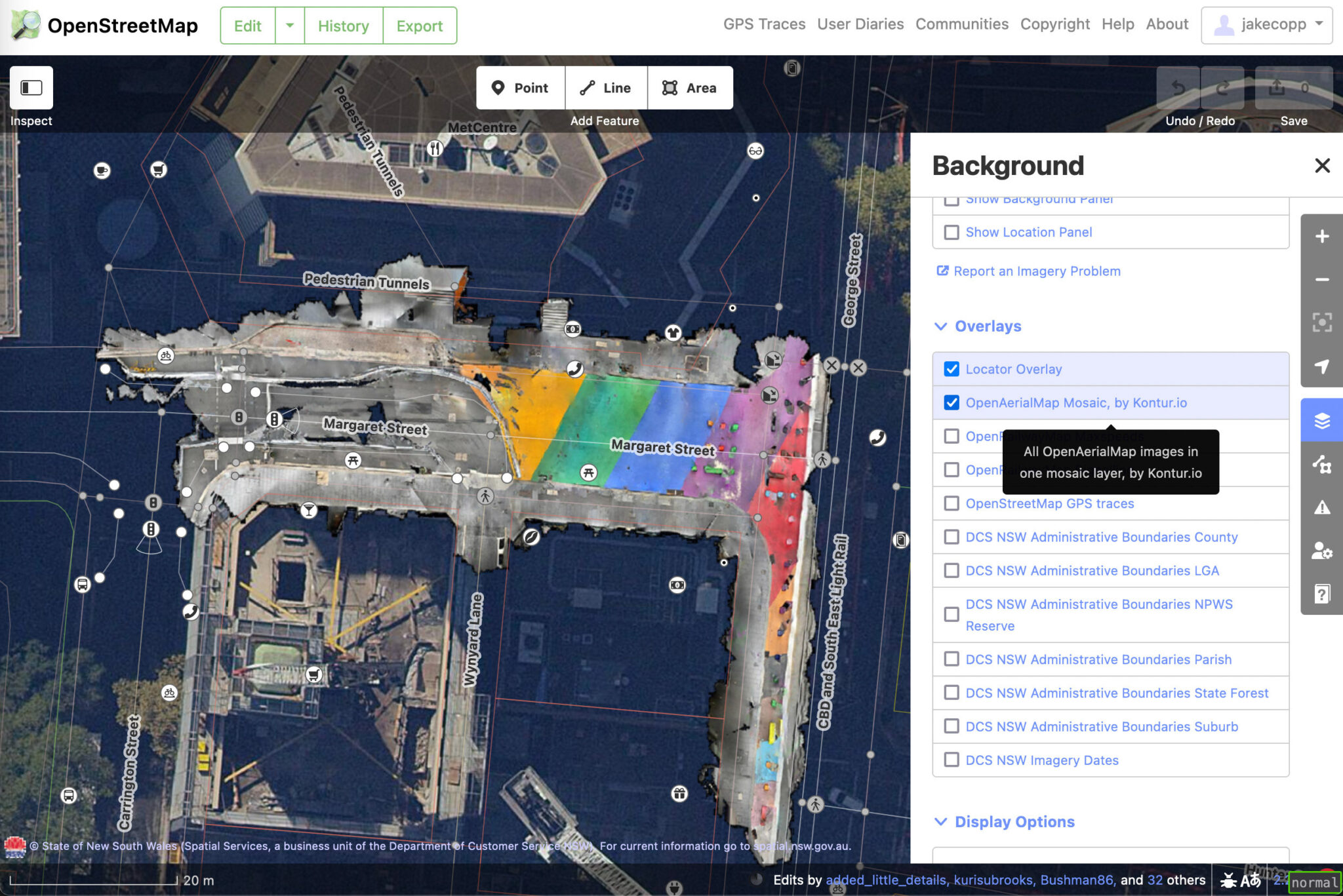
I wrote a blog post on how you can create your own aerial imagery and 3D models of streets with the built in iPhone LiDAR sensor and open source tools in the OpenDroneMap package.

I’ve found you can attach your iPhone to your bike and generate LiDAR point clouds of the kerb and cycleway infrastructure if you go slow!

https://jakecoppinger.com/2023/03/generating-aerial-imagery-with-your-iphones-lidar-sensor/

Let me know what you think! I appreciate any feedback or improvements on the process.

OpenAerialMap imagery in iD editor

Location: Sydney, Sydney CBD, Sydney, New South Wales, 2000, Australia

In Flanders, all traffic signs are open data. This information is hugely useful. Well, it could be. Most of the traffic signs date from several years back and have not been updated since. The Flemish Verkeersborden.vlaanderen project intends to change that. Municipality by municipality, we see updates starting to happen. Several of them have done a complete update, or at least do occasional additions.

In a perfect world, when the municipality decides to change a traffic situation (a new speed limit, a new one-way restriction,…), they start to work in this database. First there’s a planned sign. Then when it is installed, it becomes a real sign. The real sign is offered to the OSM mapping community (and Waze, TomTom, Here, …) and they add the info to the affected street - almost in real time.

We’re not quite there just yet, but the edits in the database that do happen are still useful. Obviously because it makes for a better map. Less obviously because it saves everyone a lot of time. We often get a mail from municipalities: “hey, we have changed reality, can you now change your map”. We want to be able to say: “oh we know, we already updated it!””

So we’re building on a tool in good Road Completion tradition to make sure that if the government provides the data, we can guarantee that we’ll be up to date. This in turn might be a little incentive for more municipalities to keep their bit of the database online. Just like in Road Completion, we “accidentally review” the government data as well. When we map traffic signs, we spot errors. Often user error, sometimes logical errors. These can then help municipalities to improve their data quality or even local reality. OSM data users will be able to see how well we keep track of new traffic signs - they won’t have to trust us on our word that the data is good.

See full entry

The Operations Working Group is looking at what it take to deprecate HTTP Basic Auth and OAuth 1.0a in favour of OAuth 2.0 on the main API in order to improve security and reduce code maintenance.

Some of the libraries that the software powering the API relies on for OAuth 1.0a are unmaintained, there is currently a need to maintain two parallel OAuth interfaces, and HTTP Basic Auth requires bad password management practices. OAuth 2.0 libraries should be available for every major language.

We do not yet have a timeline for this, but do not expect to shut off either this year. Before action is taken, we will send out more notifications. Deprecation may be incremental, e.g., we may shut off creation of new applications as an earlier step.

What can you do to help?

If you are developing new software that interacts with the OSM API, use OAuth 2.0 from the start. Non-editing software can require authentication support, e.g. software that checks if you have an OSM login.

If you maintain existing software, then look into OAuth 2.0 libraries that can replace your OAuth 1.0a ones. We do not recommend implementing support for either protocol version “by hand”, as libraries are readily available and history has shown that implementing your own support is prone to errors.

If you do not develop software that interacts with the OSM API, this change will not directly impact you. You may need to update software you use at some point.

I have been developing Street Spirit, a new style using OpenStreetMap data. It uses Maplibre GL for client side rendering of MVTs generated by Tilekiln, which supports minutely updates using the standard osm2pgsql toolchain.

To focus style development, I have set its aims as being suitable for

  • use as a locator map,
  • to show off what can be done with OpenStreetMap data,
  • to be up-to-date with the latest OpenStreetMap data, and
  • using to orient a viewer to a location they are at.

Although not complete - if a style can ever said to be complete - it is at the point where there’s enough features to give the overall feel of the map, at least for zooms 12 and higher. Lower zooms are missing many features still, particularly roads and rail and some landcover and other fills.

Because the style has a more clearly defined purpose, I’ve been able to use more of the colour pallet than many other styles, particularly compared to styles designed for overlaying other data on top of.

I’ve set up a dev instance on one of my servers, using OSM data from 2023-02-27. Have an explore around.

Some of the bigger areas that need work are

  • Missing mid- and low-zoom features
  • Missing fills
  • A consistent set of POI icons
  • More POIs

If you’re interested in contributing to the work, let me know. Contributing will require some technical knowledge in the following areas

  • MapLibre GL style specification, focusing on layers and expressions, including data-driven expressions;
  • YAML, in particular appropriate indentation for arrays. MapLibre GL styles tend to feature deeply nested arrays; and
  • SQL for writing read-only PostGIS queries if modifying vector tiles.

See full entry

Posted by watmildon on 12 March 2023 in English. Last updated on 12 December 2025.

The header from an incoming email from Google Alerts

Google alerts

In the fall of 2021, there was a notice issued renaming many (~600) natural features in the United States. There was very likely to initiate a cascade of renames for various map features. For example, the name for the road up the mountain peak will likely change to match the new name.

At the tail end of our renaming work, I set up a few Google Alerts related to the theme of the order and promptly forgot about them.

Map updates!

Starting a few months ago the alerts began firing! Each week I would get an email or two about town councils or other agencies planning to rename some feature or another.

Another one came into my inbox this morning announcing that a resort near a renamed waterway was updating it’s name. A bit of checking the resort website to confirm the new name, a few clicks in iD, et voila!

It will certainly be interesting to see whether the roadway, golf course etc get similar updates and I’ve made a note to myself the check back in a few months.

See full entry