 OpenStreetMap
Diary Entries in English
Recent diary entries


What’s there

Based on ONOSM
We need an easy way that people can add their business to the map without necessarily having to create an account and having to learn how to edit. One such way would be to add a note to the map but even then for those who don’t know very well how OpenStreetMap works they can make some mistakes by adding a note with no information other than the name (I’ve encountered many notes opened like this), so how could we improve it so that more people can have their business on the OSM? One easy way would be to create a form that would generate a note in OSM for editors to use.

By bringing a simpler design and illustrations I want it to be easy to use and ready for use in mapping campaigns and can be used by experienced mappers or even those who have never had contact with OpenStreetMap but want their business on the map

There is a Chinese account that has normalized the KFC tag that its changeset boundary is so big recently, which included Taiwan in it. The changeset boundary is so big that makes QA tools like OSMCha not function as expected, probably Overpass API limitation. The reviewer has to manully review the changeset if there is anything wrong. As a Taiwanese mapper I check if he change something inside the Taiwan boundary, and foundout he does what he said. The mapper stated in his changeset comment said he did not touch KFC in the “Taiwan area”, which in my humble option is not quite necessary.
I will recommend that even though the cause is QA tools problems, that can not check edit in a country if it is problem changeset, might be a good idea to avoid such a big changeset boundary. Split the big changeset into a much smaller, much checkable changeset that lets QA tools like OSMCha to function normally. This could avoid potiental disruption. Heavy mappeers could focus on mapping, not changeset comment discussion.
Even though Taiwan is a small place, there are many hard-working mappers that contribute to OpenStreetMap, following the truth to map stuff that exists in front of them, that can be observed by their own eyes. But sometimes we have to deal with people who do not follow the on-the-ground truth, forcing Taiwanese to accept things not observabe on the ground.

OSM in many areas has a complete street network and has for quite some time. What it is lacking compared to many map sources is a comprehensive POI index. Stores could be there but the data likely is outdated, even then you could have a major chain business that isn’t even shown on the map. So what do we do?
We don’t need some complex editor, just a stripped down editor that can leave a poi and has a search for presets and chains that makes adding one as simple as possible. From there you can add more information but by default it should just show the basics. No distractions and dead simple so anyone with a phone or on the web can easily add a tone of POIs for even a simple quick walk.
Secondly, POIs need to expire and autodeleted; to keep the information from getting stale POIs need to be checked into or deleted automatically after a year if there is no new activity. Mappers should be able to subscribe to an area and get emails warning of pending expiration. The checking API could be open to app developers.
Thirdly, we need a TEMP layer for maps a temp data layer that can be deleted daily that basically is the dumping ground for temporary data such as road obstructions, traffic and events. Basically a meta database that allows apps to share and make use of more realtime data. This can allow for more uses of the OSM map and by contributing to this could reveal closed bridges and other obstructions and improved the map. The more data that is shared between apps the more that can be improved.
Posted by TreeTracks on 12 January 2022 in English.
Hi folks, for everyone interested in OpenStreetMap’s fantastic road data… I’ve just posted a series of blogs about unsealed roads in Victoria. I’ve pitched it at cyclists rather than mappers to widen the audience, but you should still find lots of interest I hope.
https://little-maps.com/2022/01/12/the-great-vic-gravel-route-exploring-victoria-on-unsealed-roads/
It starts with the question, how far can you ride across Victoria without hitting a paved road? Then displays Victoria’s major ‘gravel zones’, and plots the route that crosses Victoria from west to east which contains the shortest possible distance of paved roads. It’s very circuitous.
A series of supplementary posts expand on the main theme and describe how the maps and routes were made. I hope you find it interesting. Best wishes Ian
Im new to this but find it very interesting…

I often see Nordic pistes on top of already existing way. This is not appreciated. I found a very good tutorial here: https://www.opensnowmap.org/iframes/how-to-eng.html
It adds examples to the “official” docu from here: osm.wiki/Tag:piste:type%3Dnordic
making minor changes to boundary adjustment
To to
Posted by Minh Nguyen on 9 January 2022 in English.
Last updated on 8 March 2026.

A recent id-tagging-schema pull request introduces presets specific to Germany that would make it easier for mappers there to tag schools by type based on locally understood terminology. It’s a great idea, one that hopefully will be extended to other countries like the United States in due time. Some Americans will see a “Kindergarten” preset and intuitively expect a complementary “Elementary School” preset too.
School type presets wouldn’t just be a matter of convenience to mappers. Local maps of the U.S. conventionally distinguish between different types of schools, namely between elementary schools, middle schools, high schools, and colleges and universities. I’d like to eventually see OpenStreetMap-based maps that make the same distinctions.

School classification has long been a tricky subject in OSM. There are at least three documented, machine-readable schemes for classifying schools:
Posted by SimonPoole on 6 January 2022 in English.
Last updated on 13 January 2022.

As every quarter I’ve updated the contributor statistics in the OSM wiki. The most notable effect is the drop off in new contributors in the 2nd half of 2021, which can at least partly be attributed to the demise of maps.me as a source of new mappers.
This is more obvious when you consider just the new users from this source
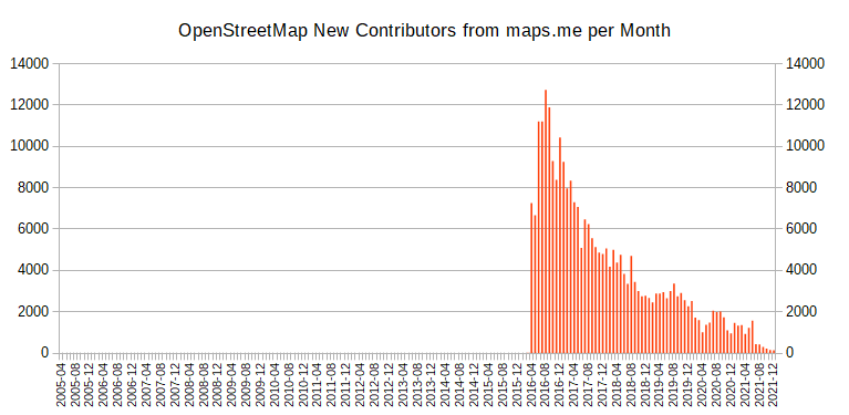
Note that the numbers include new users using organic maps, but even that doesn’t change the trend.
See my diary posts from 2020, 2018 and 2017 for more on the topic.
.png)
I’m really enjoying contributing to OSM so far.
I’m learning JOSM and adding a lot of data in Alexandria VA. Mainly creating row homes and now adding streets, city and zipcode to houses.
I add house numbers via Street Complete.
I also started a next door group. Hopefully others join! There’s a lot to do.
Posted by Mateusz Konieczny on 6 January 2022 in English.

osm.wiki/Editor_usage_stats has some interesting parts for 2021
- iD use continues to increase by percent (both edited objects and distinct users)
- iD by number of distinct users dropped from all-time-height in 2021
- end of lockdowns? OSM slowing down? 2018 to 2019 also dropped, this year JOSM edit volume went from 996 million to 905 million edits
- JOSM still used for over 50% of all contributed edits by objects
- StreetComplete is the second most popular editor (by number of distinct users), usage almost doubled
- StreetComplete is still almost not noticeable by edited object volume - 0.8%
- but last year it was 0.3%, it tripled to 12 million edits
- failed import and its revert is the second most popular editor, by count of edited objects
- 1.5% of all edits in 2021
- https://forum.openstreetmap.org/viewtopic.php?pid=760818#p760818 is an example of what was imported
- new editors: Organic Maps
- ok, “new” as it is MAPS.ME fork
- and that failed Finland forest import
- MAPS.ME continues to die, also as an OSM editor
Removing private trail from map I am attempting to update the map to remove an area listed as a trail that is not a trail and on private property. My hope is that no one will use that non-trail. I made the changes but not sure how to save them to the actual map..
Posted by amapanda ᚛ᚐᚋᚐᚅᚇᚐ᚜ 🏳️⚧️ on 5 January 2022 in English.
Last updated on 6 January 2022.

What I did in OpenStreetMap in December 2021

I am going to put this on hold, until I read more of the manual, and see what else I can pull in besides wikidata. Much preferred would be Placekey and Postal lookup information to authenticate the individual effort - no commercial, proprietary information, each building is researched and is within walking - driving distance to me.
Posted by UNGSC-DTLM-Ale_Zena on 5 January 2022 in English.
Yet another mess in Mogadishu.
The city was extensively mapped; buildings are very dense, though not every single building was added yet.
But someone opened H.O.T. tasks asking (to work in a extremely dense area) for Beginner Mapper.
Is this good for OpenStreetMap? NO, definitely
Is it good for OpenStreetMap map a soccer field 103 x 60 m (with the goals clearly visibles) as a building? NO, definitely
Who’d validate this osm.org/way/1013314708 103 x 60m building?
If anyone is following my mapping work, they’ll know that I started a tutorial series on YouTube about a year ago, in which I focus on heritage mapping, because that’s what interests me most (even if I map way more ordinary buildings during our #osmIRL_buildings campaign than I map heritage). Between Christmas and the New Year 2022, I had been wrecking my brain about what else to do tutorials about, because I thought that I had covered most things. Then I came across a Heritage Trail in County Tipperary - the Derrynaflan Trail* - and decided to take that as an example for a new tutorial series. So, I will walk along the trail described here and focus on different mapping aspects. This will give me the opportunity to talk about tags that are not necessarily heritage related, but useful for people along the trail, i.e. amenities like car parks, public toilets, EV charging points, accommodation, restaurants etc.
Luckily, the trail is only about an hour’s drive away, so even though I happen to have visited quite a few of the sites already, I might go there again for some image material and micro mapping quests. I’m also hoping to add some more photographs to WikiCommons, because this part of the country is rarely visited by foreign tourists who happen to be contributing more than the locals to WikiCommons, unfortunately.
In the first episode, I created a multipolygon relation for the trail and added the first building to it.
*The Derrynaflan Trail is named after a church site where a very famous early Christian hoard was found which is now housed in the National Museum in Dublin (I might do an episode visiting it).
Please feel free to watch along and contribute with ideas about what else to focus on in future episodes!

In December of 2021 a bi-annual International Cartographic Conference was held in Florence, Italy.

Because of Covid it was a mixed conference, however ~200 people (my estimation, I do not have an official number) have attended on site (with many more participating on-line).
OpenStreetMap was mentioned a lot. This is a good thing, but… the only good thing. It was always mentioned just as a data source. And it seems everybody is taking for granted that OSM data while being heterogenic in saturation is at least in schema (tagging) a consistent thing and slowly smartly evolving, rather than eroding. Nobody new or even expected that schema in OSM can be changed by anybody, even people who have absolutely no clue in Cartography/GIS. And this is not only a possibility, but a reality.