 OpenStreetMap

file:///home/ferdaus/Pictures/Chittagong/DSC03514.JPG
Diary Entries in English
Recent diary entries

I love maps. I edit them when I poop. I have a lot of edits.
Posted by Nicxon Piaso on 25 January 2022 in English.

Malalaua District is one district of the Gulf Province. Gulf Province is known for most of its landmass covered by swamp and mostly hydrological networks in the Province. An hassle for Mappers will be trying to map out all land-features especially the lowland rainforest which is predominant in most of coastal areas of Papua New Guinea.
This area is not fully mapped and we have much to be populated in OSM. Gulf Province itself is one of a beautiful Province in PNG with its lush forest and water features making it a tropical paradise for most of the inhabitants there.

A handful of minor changes, mostly around changeset behaviour:
- You can now choose to automatically close a changeset after saving
- Trying to save into an already-open changeset will show a warning dialogue if the resulting bounding box would be too big
- The currently open changeset is automatically closed when you quit P3
- Unpaved roads (as indicated by their surface or tracktype tag) are now drawn with a brown casing
- Keyboard issues on the latest Macs are fixed
Plus a couple of other little fixes. You can download P3 at https://www.systemed.net/potlatch/download/ .
P3 continues to be offered with Mac and Windows builds plus an AIR file. I’m hopeful that there’ll be a Linux build in due course but that’s waiting on licensing decisions by Harman, who maintain AIR. The Mac build is fully notarized; the Windows build is self-signed so you need to click through a warning dialogue (I’ve experimented with using signtool to fix this but the whole process is so deeply painful that I gave up after many hours of trying).

I believe it is is desirable for OSM to be used more regularly as a general map for routing to locations. Replacing proprietary mapping tools such as Google and Apple Maps. In order for it to become a viable replacement it needs a good data set of locations to route to. I’m sure a very uncontroversial opinion within this community.
In my home location of the Gold Coast, Australia, there is a severe lack of listed houses with marked addresses. A personal pain-stake of mine, for it is just not feasible to use OSM on my phone for driving directions.
So, I have decided to map theses addresses myself.
My first goal is to fully map out every house within the suburb of Palm Beach. At the time of writing I have already completed a stretch of blocks between Thrower Dr and Palm Beach Ave.
By mapping houses, I mean tracing building outlines via Aerial Imagery and assigning their corresponding address. I am collecting addresses by Local Knowledge and Surveys (walking down the streets, I figure, a good source of exercise). Additionally, I am tracing corresponding driveways.
My main goal is to list addresses but I will occasionally edit/add other data such as footpaths, playgrounds, benches, and any other points of personal interest I notice on my journeys.
I will attempt to keep changesets small, basically submitting one street at a time.
This is not an official declaration of an OSM Project. It’s just more of a personal scheme of mine. But I do welcome any nearby mappers to join in the fun, if they wish, and contribute housing addresses around the Gold Coast area.
Infrequent updates on this personal project will be added to my User Diary.

For the past few weeks I’ve been making a concerted effort to map solar panels across rural areas of North & Central Wales (Powys, Gwynedd and Ynys Mon - Anglesey), so far with good results. I’m using a thorough search technique which looks at individual clusters of buildings from Ordnance Survey Open Data (which is complete for Great Britain). This means I see lots of other things which need mapping, but from experience I know it’s important to focus on the specific task. However, I have followed up some of the more striking things, which I plan to report in a series of posts.
First up was a striking structure in the middle of farmland on the Llyn Peninsula. It was pretty obviously a high-tech milking machine: milking parlour seems a bit quaint for a pretty sophisticated bit of kit.
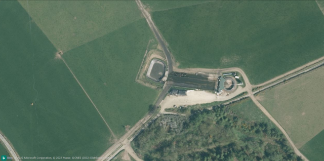 Bing Imagery (close-up view).
Parcel lockers are a newly approved feature in OpenStreetMap. They are now included in the “Communication” category with a box symbol. I also included the deprecated tags vending=parcel_pickup;parcel_mail_in, vending=parcel_pickup and vending=parcel_mail_in. These will render with a bright red symbol to indicate deprecation, also there’s a warning in the popup.
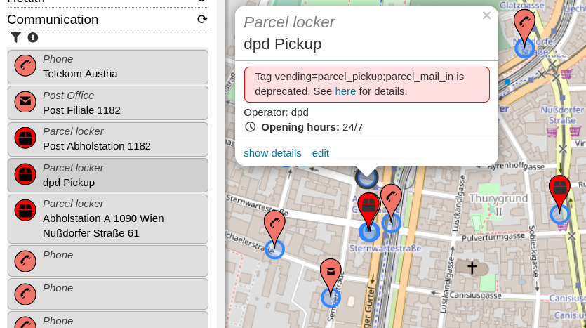
- Do you know of more tags which should be indicated as deprecated? I was thinking about adding some QA features for some time, so this is a good opportunity.
- There’s a new string to translate for this deprecation warning. Find the translation system here.
Posted by Minh Nguyen on 23 January 2022 in English.

I’m running for reelection to the OpenStreetMap U.S. board of directors. In my 14 years of grassroots mapping, organizing local communities, and evangelizing OSM, I’ve witnessed the community and ecosystem grow tremendously while remaining true to its humble roots.
The past year has proved that big things start small. Who could’ve predicted that a complaint from a park manager would turn into a thoughtful Trails Working Group, or that an offhand comment in a long Slack thread would inspire our community’s cartographers to come out of the woodwork and collaborate on a new OSM Americana renderer? We tend to think of OpenHistoricalMap as a daunting blank slate compared to OSM, but you should’ve seen people’s eyes light up at WikiConference North America when they learned about the project. You make all of this possible through your creativity, hard work, and financial support; the board is right here alongside you to connect the dots and grease the wheels.
OSMUS has matured to the point that the board no longer needs to run the day-to-day affairs of the organization, which frees us up to do what we’re better at. It’s up to us to have a big-picture, long-term vision for the organization. We funnel the U.S. community’s many needs into a coherent strategy. As representatives of the community, we engage with other communities and organizations, seeking to turn their interest in OSM into a source of energy and diversity for the project. Collectively, we support our staff by providing ideas, scrutiny, and encouragement in healthy doses.
Hello and thank you for reading why I’d like to continue serving on the OpenStreetMap U.S. Board for 2022!
Serving on the board this past year has been a great honor and learning experience, but it has been too short a time, especially during a pandemic, for me to help the OpenStreetMap U.S. community and expand the awareness of project in the way I’d like.
There are three particular avenues along which I have been helping support our executive director, Maggie Cawley, and the OSM U.S. organization increase the reach of OpenStreetMap:
- Education Connections – expanding the awareness of OSM among students as something to which they can contribute as well as use as a data source
- Community Connections – encouraging local groups to engage in OSM to help address their community needs
- Professional Connections – opening communication with government entities to create symbiotic relationships with OSM
I have spent the past year working on creating these types of connections. For example, I am facilitating the Trails Working Group along with Maggie, to help federal and other land managers work cooperatively with OpenStreetMap. The progression I envision is building more structures within OSMUS to make initiating and maintaining these kind of connections; either with academics groups, diverse communities or government entities; more approachable.
My main goal is growing the OSM community in an open and equitable manner.
Paraphrasing what I wrote last year, because it is still true: I am a scientist and outdoorsperson at heart. I have a degree in earth sciences and turned to geospatial technologies through a research project. I presently work in an academic library as a geospatial data scientist supporting students and faculty. I introduce OpenStreetMap whenever possible through research consultations and the MaptimeMileHigh meetup group I run.

Who am I?
Hello, my name is Daniela Waltersdorfer, although to some I’m known as Dani. I am from Lima, Peru and after some moves, my family and I ended in the U.S. Fast-forward to now, after a few moves on my own, and now I find myself as a resident of the wonderful District of Columbia. I’ve had the pleasure and joy of serving in the OSMUS Board for the past two years, two very special and difficult years. As a professional I work in the Transportation Industry, where I help many transportation agencies with their transit, logistics, supply-chain, and asset management needs. I love cities and advocate for proper accessibility and mobility for people and goods. In the past, I’ve led Maptime Boston and Maptime Miami, where I (along with my awesome co-leads) provided GIS and mapping education to the local communities, led mapathons, and hosted a space for everything map-related in our urban areas. In 2019 I joined in on the OSM US Code of Conduct Committee, developed to lead efforts to foster a diverse and inclusive OSM US community, and in 2021 the first ever and this first ever OSMU US Code of Conduct was published (osm.wiki/Foundation/Local_Chapters/United_States/Code_of_Conduct_Committee/OSM_US_Code_of_Conduct#OpenStreetMap_US_Code_of_Conduct). Last year I committed to make this, our community, more welcoming. Albeit it being a difficult year, I believe what we learned from the obstacles in 2020 pertaining to the COVID-19 Pandemic, led us to be optimistic and proactive. Listed below, you can find some of the initiatives and pushes that I was involved in this past year, with the help of our super Executive Director, as an OSMUS Board Member:
• Continue hosting Mappy Hours - A great way to engage our community from all over the U.S. in a virtual setting

Currently learning the ropes at Unique Mappers Network Nigeria. Glad to have been introduced to this project and looking forward to future events.
Posted by amapanda ᚛ᚐᚋᚐᚅᚇᚐ᚜ 🏳️⚧️ on 22 January 2022 in English.

Recently someone asked how to find OSM users who’ve left a changeset comment, but have not edited themselves. (Technically the initial challenge was for a one line bash script 😉).
Here’s how to do it.
In OpenStreetMap, people can change their username, but OSM data provides an unchanging numeric user id (uid) for users, which we use here.
First download the dump file, from the OpenStreetMap data download serivce (planet.osm.org) ⁽¹⁾.
aria2c --seed-time=0 https://planet.openstreetmap.org/planet/discussions-latest.osm.bz2.torrent
This will download discussions-YYMMDD.osm.bz2⁽²⁾, which is currently about 5 GiB.
I had to write a new tool, anglosaxon to easily parse large XML files like this into a TSV file format⁽³⁾. This programme works on all XML files, maybe it’s useful for other problems you might have. Install that first.
bzcat discussions-220110.osm.bz2 \
  | anglosaxon \
   -S -o changeset_id --tab -o changeset_uid --tab -o comment_uid --nl \
   -s comment -v ../../id --tab -V ../../uid NO_CHANGESET_UID --tab -V uid NO_COMMENT_UID  --nl \
   | gzip > changeset-comments.tsv.gz
This took about 45 minutes to run on my machine, and the output is about 4 MiB (19 MiB uncompressed), and has about 805,000 lines. This step takes the longest.
We create the list of all uids who have opened a changeset:
zcat changeset-comments.tsv.gz | cut -f2 |uniq|sort |uniq > changeset-uids.tsv
Then a list of all uids who have left a changeset comment:
zcat changeset-comments.tsv.gz | cut -f3 |uniq|sort|uniq > comment-uids.tsv
Then we compare, what’s in one but not the other.
comm -13 changeset-uids.tsv comment-uids.tsv |sort -n > uids-comment-without-changeset.tsv
Et voilà! Sin é! And there’s your results. 🙂 The file is 29 KiB, and has ~3,500 entries. I’m surprised it’s so high.⁽⁴⁾
You can find all the changesets that a uid has commented on with this command, (replace UID with the uid)
zcat changeset-comments.tsv.gz | grep -P "\tUID$" | cut -f1
Posted by Gustavo22Soares on 21 January 2022 in English.

When we create a goal of how to increase the number of mappers in a community we have to take into account who will consume and how this data reached the final public, it is a proportional account, the greater the number of consumers the greater the number of mappers in the region. We need to consider OpenStreetMap as a complex ecosystem that goes beyond the open mapping community and that each group has specific needs. I propose that to better understand the OSM ecosystem we divide it into three groups of users: consumers, distributors and producers, and exercise a little reflection on each group
Consumers: are users who use the map as an end product for navigation, data visualization, planning, search, etc.. without contributing actively.
- How do they access the maps? (whether for navigation, transportation, exploring, trails, etc.)
- How often do you use maps?
- What impediments do you have to use OSM in your daily life?
Producers: all those who actively contribute to the map the known mappers.
- What is the profile of mappers in the region?
- What problems do these mappers face? (socio-economically)
- What tools do they use to map?
- How can we motivate these mappers?
- What are the objectives of the mappers for the region?
Distributors we can classify distributors as those who use the map as a basis for their applications within the communities such as a government that needs to disseminate geographic data or a company that needs its consumers to find its physical stores or any application that needs a map to show its data.
- How can we attract more distributors?
- What is stopping a distributor from using OSM?
- How can we improve our tools to attract more distributors?
- What data do distributors in the region need?
By asking these questions we can get a more complete profile about each group and define ways to target each group according to their interests and needs.
Posted by TagaSanPedroAko on 21 January 2022 in English.
Problem users, whether it be vandals, trolls, spammers, or undisclosed/”rogue” organized mapping projects, is considered a problem all across OSM, but I would like to bring up some top examples of notorious problem users and major incidents involving organized mapping groups from the Philippines. Such edits are a perennial problem in the Philippines OSM community, and particularly in the time of COVID, I think the extended mass quarantines has make this problem worse as more people will be spending time in front of their computer, laptop, cellphone or tablet. While we have a ticket system to monitor suspicious editing activity, I feel it’s kind of Wild Wild West in OSM in the Philippines; new users are increasing (usually ones who only edit a few features, usually in their home area, before riding off into sunset) and not everyone will be patrolling the map for fishy changesets.
Vandals/trolls
bryanpiczon
Long-term vandal, often adding fantasy features usually in the Eastern Visayas region of the Philippines. Has abused multiple accounts. Mostly interested in power lines and roads. Also vandalized areas outside the Philippines,
Joey Samson
Vandalism related to speculative real estate and transportation projects, especially around Manila. Some edits resulted in mass deletions (e.g. a former movie theater south of Manila). Also pesters users to add admin boundaries. 2 accounts traced so far (1 deleted following block)
Niwre Erv Apotseg
Vandal from Mindanao. Mostly duplicated roads, but also have added fictional features. Comments often nonsensical alphabet soup. Had 3 sock puppets.
Mass copying from GMaps

Never Stop learning Because OpenStreetMap Never Stop upgrading
We’ve got to know that slow by slow makes journey. I encourage Local communities as well as underrepresented ones ,Mothers , Girls To keep mapping as long as it gives fun and no specific time to do so. Map in your lovely moments slow by slow we shall have a Women community of active Mappers.
OSM Rwanda community.

%20by%20Vince%20Emond.jpg)
As many of you know, over the last 6 months or so, we have been reimagining what the future of the Tasking Manager could look like for HOT and the wider Humanitairan and OSM communities.
We have taken the time to reflect and consult in an effort to create a new model for Tasking Manager that aspires to get the Tasking Manager back to its community software roots. You can read about the ‘TM Tomorrow’ here to get up to speed and find (or contribute) questions and answers you may also have.
As the next step in the TM Tomorrow journey, we are now looking for an individual who would like to volunteer as a community caretaker for the Tasking Manager and are open to anyone who would like to express their interest in this position. You can read the full position description here >
Position description tldr;
* Expected time commitment is about 5 hours a week.
* Responsibilities include, project direction, roadmaps and issue prioritisation.
* Will be supported by TM Maintainers, hot_tech collective facilitator, and hot_tech in general.
A few questions that have arisen since we first started talking about this idea that may be helpful to those considering expressing their interest (or feedback).
Q: Why are you doing this?
The short answer to this is to reduce our control and reignite the collective. HOT recognises its role in taking primary control for the project in recent years and the effects of this (and recognise those effects haven’t always been positive). While this did allow us to move things forward, we also recognise our control has reduced engagement of our collective of contributors, stakeholders and users. Moving forward, we want to reduce HOT’s control of the project and shift power back into the collective, where HOT serves and supports the collective, rather than substituting it.
Posted by Tomas Straupis on 19 January 2022 in English.
Last updated on 24 January 2022.


“Cartographic generalization, or map generalization, <…> is a core part of cartographic design.”
Yet it is quite often unknown or understood incorrectly/partly. This article has a pretty good description of generalisation, it’s purpose, history and main operators with some examples of where OSM-Carto is missing generalisation.

GPS tracks versus image aligned to a surveyed position (cm level RTK) 7 km away - displacement of 20+ meters North South axis.
Surveyed position might have image provider problem, that is, improper stitching and alignment of photo imageries during processing.
GPS tracks has the problems of inherently inaccurate receiver, placement of phone during recording, and possible Kalman filter in the gps app.
Mappers have the problem of not knowing that only JOSM has the imagery alignment database.

Hi all,
Just a quick heads up that MapComplete 0.14 is deployed!
Apart from lots of fixed bugs and performance improvements, a new theme showing OpenStreetMap notes has landed! Especially the filter functionality should come in handy
And of course, there are plenty of (new) themes, such as the street lighting theme (thanks Robin!) or the postboxes and -offices map (by nicolelaine).
And -by now- over 1000 individual contributors have used MapComplete.

Inspired by Yousuke Ozawa’s SatelliteFonts, I wanted to create something similar with OpenStreetMap.