Diary Entries in English

Recent diary entries

Posted by arnalielsewhere on 12 September 2021 in English. Last updated on 13 September 2021.

If you want to translate this post to be more comprehensible, I recommend to use deepL translator.

Disclaimer: All opinions are mine and do not necessarily represent opinions of HOT or other organizations/groups I am affiliated with.

The HOT Board and Chairperson Election period this year started this month of September. Both positions require that you are a voting member to be able to run, nominate and vote.

PS. Becoming a voting member is another cycle/election :)

I’d like to share five (5) challenges or “dare” to the HOT Voting members (which includes Board members and chairperson).

#1 Unengaged membership: How can we engage 1M contributors if we cannot engage our 217 (and growing) voting members?

HOT received funding from the Audacious Project last year - “Over the next five years, HOT will engage one million volunteers to map the places that are home to one billion people.”

When I applied for my staff position, this has been one of my strong drivers/motivations: to meaningfully engage contributors/communities (including the voting membership), and benefit from the work that HOT does. I believe the voting membership is one of the most important of these communities but hasn’t been prioritised in recent years.

I challenge the HOT membership, how can you help engage your fellow voting members, esp. those you nominated as a voting member and vice versa?

#2 Community Participation: How do we actively participate and support communities/groups locally (your local communities), regionally (eg Open Mapping Hubs), and globally (e.g. HOT / OSMF Working Groups)?

HOT shifted from global to regional structure to ensure that power, decision-making and resource allocation happen much closer to the communities we seek to support and in which we want our impact to be. How do you think the voting members can support the Regional Hubs and local communities?

See full entry

Location: Montezuma County, Colorado, United States

The division of the Republic of Djibouti (RDD): Total Area: 23,700 km²

the following text shows how the Territory of RDD is Divised and coded:

• afr_dji_l02_2011 the Republic of Djibouti (RDD); RDD constitutes the second level administrative unit. Represents The total area of ​​the country is 23,700 km².

• afr_dji_l03_2011 the Regions; The region constitutes the 3rd level administrative unit. Represents The administrative division of the Prefectures or districts of the Region.

• afr_dji_l04_2011 the Sub-Prefectures: The Sub-Prefectures constitute the 4th level administrative unit. Represents The administrative division of the Sub Prefectures of the Region.

• afr_dji_l05_2011 the Communes (only in the Regions of Djibouti 5 or the capital city); The 5th level administration subdivision constitutes the Commune. the Djibouti region is the divided in two part urban and rural: o The Communes of Djibouti city are urban, o And the rest of the Region are rural.

• afr_dji_l06_2011 Arrondissement; The 6th level administration subdivision constitues the Arrondissements. there are 6 (A1, A2,..,A6).

• afr dji l07 2011 les Quartiers; The 7th level administration subdivision constitutes the Quarters and it is divided in two part quarter and locality o The quartiers for Djibouti-ville. o The locality for the rest of the country

Location: Oue`a, Tadjoura, Tadjourah, Djibouti
Posted by TylerOSM on 10 September 2021 in English.

HOT members - welcome to the 2021 election cycle! If you’ve been considering running for a board seat, or simply my informal take on things, read on!

This year, we have several unique factors at play:

  • HOT has just entered (as of July) its second year of implementation of Audacious Project implementation, working toward a goal of engaging 1 million contributors to map an area home to 1 billion people across 94 countries.
  • The organization has gone through a period of rapid change in the past 12 months, opening two regional hubs, adding roughly 45 staff members, doubling our annual budget, and putting the organizational foundations in place to dramatically scale up community support. We’ll continue to scale from 2021-22.
  • The environment around us has also changed dramatically, opening up new possibilities with recent technical advances and forcing us to re-think ways of working under Covid-related movement restrictions.
  • Lots more has been happening: see our Annual Report (I’ll write more on where we stand and where we’re heading next month).
  • Amidst all of this, five of seven board seats are up for grabs.

I’ve been reflecting on this. As someone who works to serve and expand the open mapping / OpenStreetMap movement every day, what would position HOT in the best way to support the movement? Given the changes and uncertainty, what specific skills would add the most value? What specifically do we need coming out of this year’s Board of Directors election cycle?

I’ve come up with a rough grouping of skills and experiences that have the potential to add significant value as part of HOT’s Board of Directors. HOT has an incredible diversity of lived experiences in our membership, though, so if you don’t see your particular experience here, it doesn’t mean it wouldn’t benefit HOT.

In no particular order, here’s my top five archetypes:

The serial entrepreneur or tech trend-setter

See full entry

Posted by SK53 on 8 September 2021 in English.

I was intrigued by the photo on the wiki illustrating the hardest level of the Swiss Alpine Club scale for mountain hiking (known as SAC Scale on OSM and tagged with sac_scale). I couldn’t identify the location and wondered by looking for ways with the tag I could do better.

A quick overpass query revealed widespread misuse of the sac_scale tag for true alpine climbing routes which the Swiss Alpine Club grades using a completely different scale.

A few of the more egregious examples:

  • Geant-Rochfort Arete. A classic high-level snow ridge encompassing a couple of 4000ers. Tagged with highway=path and sac_scale:

Aiguille de Rochefort

Description of route on Hikr.

  • Biancograt of Piz Bernina: apparently trail visibility is horrible, which is a bit of a surprise, because the ridge is rather narrow.

See full entry

Location: Pontresina, Maloja, Grisons, 7504, Switzerland

tldr; hot_tech is running the second round of an ai-assisted mapping study
Call to action: please sign up to participate or share with your networks
time: read: 5m | sign-up: 5m
best before: Sept 17th, 2021

Hi all!

As some of you may remember, earlier this year HOT undertook an experiment to compare tradiational mapping with AI-Assisted mapping. After the first round of results have been gathered (soon to be released), hot_tech will be undertaking round two (Sept 17th, 2021) and we are looking for beginner mappers (<50 changesets) to join the study.

The experiment is designed to compare the results of traditional remote mapping workflows (editing in ID Editor) with emerging AI assisted workflows (editing with RapID). To do this, we will be conducting mapping experiments of two locations (Uganda and US), with beginner mappers (<50 changesets) using the two different remote mapping workflows (RapID and ID).

On Sept 17th, 2021, we will run one mapathon of 90 minutes, with participants being randomly assigned - prior to beginning mapping - to map building footprints with either ID or RapID. Data will be gathered on the existence of map features in two locations (US and Uganda) from which we will compare the completeness of mapped features and similarity of map features when compared with an OSM reference dataset.

For the mapathons we will be using convenience sampling from our networks by generating a public call for participants.

A couple of specific asks, please email if:
_ You would like to be involved in any capacity (organising, recruiting, sharing, supporting, please shoot me an email)
_ You would like to support the mapathons specifically, that would be great
_ You would like to participate in the mapathons please please sign up to participate HERE »

Thanks all, I hope everyone is safe and well and looking forward to exploring this with you all soon.

Kindness,

bo

Location: Naz, Esserts-Salève, Monnetier-Mornex, Saint-Julien-en-Genevois, Upper Savoy, Auvergne-Rhône-Alpes, Metropolitan France, 74560, France
Posted by SimonPoole on 5 September 2021 in English. Last updated on 17 December 2021.

As a rule of thumb, the primary name would be the most obvious name of the feature, the one that end users expect data consumers to expose in a label or other interface element.

From the OSM wiki Key:name

I’m currently tidying up a couple of loose ends in preparation for the release of version 16 of Vespucci. One of those dangling bits was supporting the new format of the name-suggestion-index (NSI).

The NSI was conceived back in 2013 by Aaron Lidman as a list of canonical name spellings for chains of stores, restaurants and other similar facilities, most notably for use in iD. Vespucci has supported use of the NSI nearly since day one, see a diary post from 2014 (this works quite differently in current Vespucci versions). Since then it has morphed to a, supposedly, authoritative source of tagging for a very wide range of objects. Some would say that the current version has expanded its reach far beyond what is actually useful (flagpoles ffs), but that is not the topic of this post.

Prior to the release of iD 2.20 the NSI had been in a long period of stasis with updates being made to the data, but these were not actually being deployed and given the larger format changes I had all but forgotten about it and the data in Vespucci was really old. However over the last couple of months some colleagues pointed out some weird behavior in Vespucci and iD when using NSI generated presets for tagging. In particular name tags are being added to things like excrement bag dispensers and automated postal package depots.

See full entry

Posted by Gustavo22Soares on 4 September 2021 in English.

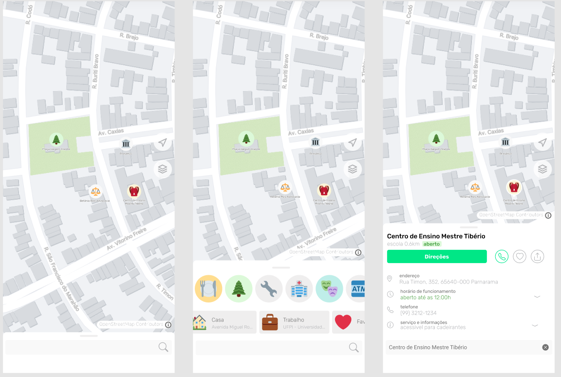
As already mentioned in the previous text OpenStreetMap is not so friendly to the common user but serves very well for cartographers, I also received many comments that OSM is not a final product but a shared knowledge base and even some comparisons with linux… But using OSM should not be difficult or depend on the rebrand from big companies, I believe that it has a way to reach the common user and win market and being opensource and still bring more mappers to the community.

For some time now I have been working on what would be an ideal client that I would really use and recommend to my friends and colleagues. This has been growing since I read the article The Mobile Map App Part I: The Void so I decided to create a draft:

hermes.png

But to get this idea off the paper I need your help, if you have some experience with Flutter or React and want to take OpenStreetMap to a new level please contact me: gustavo22soares@pesso.al

Location: Centro, Teresina, Piauí, Northeast Region, Brazil
Posted by ExecutableFiles on 3 September 2021 in English.

I’ve noticed that Anchorage has several bus routes, yet only one has actually been somewhat put on the map (route 102). I’ve looked into what setting up a bus route would look like and after setting up another one halfway (route 10), I’ve figured out what needs to be done in order to complete a large project like this.

First off, Openstreetmap is not very good with creating a bus line easily, as tagging needs to be in a specific order according to the Wiki page on bus routes (the issue is currently being looked at as of now), so I think the method of mapping bus routes will be most efficient when done this way:

  1. Each bus platform/stop must be mapped and placed into a relation before any route is mapped with ways. If the ways are set up first it can be quite a pain to move the bus stops to the top afterwards. I made this mistake when setting up bus route 10 and it was not fun.
  2. After that is done, the bus routes can finally be placed down. It doesn’t matter as much if every stop in Anchorage has been mapped so long as all the bus stops on that specific line is mapped out.

This is a pretty large project that’s going to take a bit of effort, so any outside help is greatly appreciated. Also, if you’re knowledgeable in creating bus routes and you see any errors in this method or my mapping, please feel free to correct me or the issue.

Location: Anchorage, Alaska, United States
Posted by assanges on 3 September 2021 in English. Last updated on 4 September 2021.

OpenStreetMap must not be the petri dish of political-driven nonsense

Yet here we are again, the Chinese Commies just spit on everything they thought was rightful. Yes yes, I explicitly use the term 'Commies' as gallantry since I came from 'the Taipei and environs' by their courtesies. BTW, 'Taiwan' or 'Formosa' is the place if you can't recall.

I was rather indolent to express any political views on the OpenStreetMap as it should be a site to record facts, not a place to be poisoned by political flim-flam. However, the landscape has changed too much from a niche and friendly environment to a colossal and somewhat hostile one.

OpenStreetMap is not and shalln't be the sacrifice in the political struggles

More and more Chinese mappers joined as China rises, but many rather acting irrationally and nonconstructive. These mappers can mainly be categorised into 4 major doctrines:

  1. OSM datasets exploiting: denying the existence of Xinjiang internment camps, the de facto status of Taiwan, Penghu, Kinmen and Matsu, nor the territorial dispute on the South China Sea and Pinnacle Islands;
  2. Invalid notes abusing: creating notes unrelated to data qualities and asserting Chiese political view;
  3. OSM wiki vandalising: improper editing on the page ‘Taiwan’ and clearing OSMTW community early discussions;
  4. Heavily mapping on unrealistic constructions in a foreseeing future: e.g. Beijing-Taipei Expressway, China National Highway 319 (Kaohsiung-Chengdu)

Unfortunately, all of them were never cared to listen nor discuss, while the community members try to be friendly and sagacious. Which let me rethink the need to embrace or cope with such gibberish, rather.

See full entry

Location: Station Front, Taipei, 10018, Taiwan
Posted by Lejun on 1 September 2021 in English. Last updated on 2 September 2021.

Tag’s use

While the amenity=parking tag is used “de facto”, the amenity=parking_space micromapping oriented tag has been introduced and approved by vote on 2011-05-01. The main reason for it’s introduction is to help people, disabled or not, easily find parking spots inside parking lots without any important downside to it.

Other voted proposals introduced the parking:lane=* and parking=street_side tags and while those are quite useful (I’m still reserved concerning the first), I’d rather map parking spaces directly as those kind of parking’s capacity is generally quite low. The parking:lane proposal even adds:

Consider using parking:lane=* as a simple alternative if the streetside parking spaces are stretched over a longer section of the road and no micromapping of these areas is desired.

Ha! Which fool wouldn’t want some micromapping in its life? Micromapping is love, micromapping is but the purpose of life.

The tag is especially useful in combination with the footway=acces_aisle tag (not to be confounded with service=parking_aisle which is oriented towards vehicular routing) which is used for pedestrian routing in parking lots.

Tools

This tutorial makes use of the JOSM editor along with the BuildingsTools and Gridify plugins and the high resolution of aerial imagery in France. Some similar functions may be found on other editors that I don’t know of, feel free to try and find your own workflow in the journey for the slickest parking lot micromapping.

“Parking:orientation”

The main difficulty about mapping parking spaces comes from its typology. Up to now I have found four different kinds of geometry and I’ll go through them from the simplest to the hardest to map in my opinion. The overall pattern of those is implicit and it’s recommended to use the parking:orientation key to specify if necessary.

Straight (Parallel or perpendicular)

See full entry

Location: ZAC de Châteaufarine, Chateaufarine, Besançon, Doubs, Bourgogne – Franche-Comté, Metropolitan France, 25000, France

This diary explores the problems with the OSM Wiki entry for service=driveway, and why is there a need for service=driveway2. In the process, it also describes the headaches encountered while trying find a optimal solution. However, deeply entrenched opinions makes this process untenable.

Need for clear indication of classified service way type

The topic of discussion will need to begin on how OSM tags are designed in an hierarchy, which begins with initial key-value pair of highway=service, followed by classifier tags service=driveway or service=parking_aisle. Note that highway=service without any service=* does not tell the data consumer if this is simply a minor way that is un-classified (not yet assigned a classification type such as parking_aisle or alley or driveway), or if this minor way is an implicit driveway. In general, a data consumer will assume that the way is un-classified, instead of assuming that it is an implicit driveway.

The classifier issue is the first issue present in the service=driveway Wiki entry - that suggests that minor ways linking from major roads to parking_aisles should be tagged as an implicit driveway with no classifier tags.

  • This means that data consumers are unable to determine if the way segment is un-classified, or if it is indeed an implicit driveway when such minor service way connected to parking_aisles are encountered..
  • Similarly, a user whom just want to quickly add minor service roads but does not perform classification will mean that data consumers cannot identify if such ways are classified or un-classified, and therefore prevents accurate assessment if further classification is required.

Definition of driveway

See full entry