Diary Entries in English

Recent diary entries

We seek your community input - please help us by sharing the Etiquette guidelines and giving input on the OSM wiki by September 8, 2021. We also have some upcoming consultation meetings to hear your views. ## Announcement

The LCCWG moderation subcommittee is holding two online public meetings about the revisions to the current Etiquette Guidelines, which are now open for public comment.

The draft guidelines are found here, with comments open to Sept 8:

Both public online meetings will be held via Big Blue Button in this room:

Two timeslots to accommodate a global audience.

Meeting #1: Thursday September 2; 1400 UTC (your time zone)

7 AM Pacific Time (US) 10 AM Eastern Time (US) 2 PM UTC 4 PM Central European Time

Meeting #2: Saturday, September 4; 06:00 UTC (your time zone)

11:00 PM Pacific Time (US; evening of Sept 3) 02:00 AM Eastern Time (US) 06:00 AM UTC 08:00 AM Central European Time 09:00 Nairobi 11:45 Kathmandu 1300 Jakarta 1400 Manila 1600 Sydney

Give input on the OSM wiki by September 8, 2021

See full details for the Etiquette and moderation process on the wiki -. The draft guidelines are found here, with comments open to Sept 8th, 2021

With thanks on behalf of the subcommittee

Location: Plainpalais, Geneva, 1205, Switzerland
Posted by messpert on 29 August 2021 in English.

I have mapped areas of Bodmin Moor especially around Minions which was originally a mining settlement. Large parts have been mined until around 1900, but it is likely that there has been mining since prehistory.

Early mining, as least medieval, was largely based on streamwork. This is described here (https://historicengland.org.uk/listing/the-list/list-entry/1020051). That describes a particularly large example near Minions. This website (https://www.aditnow.co.uk/Photo/Gonamena-Tin-Streamwork_50013/) includes some photographs.

As seen in those pictures, the ground is heavily disturbed. That case is fairly extreme. Often the area is smaller, but usually following a stream, and only a few metres deep. Frequently the ground is sandy with fine gravel, presumably from the extracted waste. Actually that is true in places at Gonamena, and it is also true of other smaller workings around Minions.

We don’t (yet) have any good tagging for these places, but I had used landuse=surface_mining which I think captures these distinctive areas quite well. Together with disused=yes. Unfortunately another mapper decide to change that tagging to landuse=quarry which is just plain wrong.

I have now changed to historic=mine (I am not keen on that) and landuse=disturbed (also not really a landuse) until someone comes up with better ways of capturing these special places. Perhaps I might change historic from mine to surface_mining.

There is a thread on talk-gb@openstreetmap.org about this.

Versão em Português link

Disclaimer: All the text you read below is based on an online research aimed at the Brazilian market. survey link

It isn’t news - or shouldn’t be - that OpenStreetMap has a great value in sharing local information. It is a social impact tool for minorities and humanitarian aid policies. Despite the big efforts thousands of mappers who dedicate themselves every day to improve the maps, added to the diligent efforts by the BigTechs to promote their own services, the OSM is far from being the most ppopular map in the world. Or, at least a reference as big as its sister, Wikipedia.

A Hidden Gold Mine

Out of a group of geotech enthusiasts, the OSM is totally unknown to the general public. As we could see in the survey, about 68% of the participants had never heard about OpenStreetMap. Although most likely having had previous experiences with one of the various contact points (Tesla, SnapMap, BigMaps, Apple Maps, Facebook, Strava, Mapbox), most people still didn’t know about OpenStreetMap.

If you’re concerned about whether people see or not your work on OpenStreetMap, the answer is simple as that: Of course they do. They just don’t know where it comes from!

The main reason for this omission is that companies often try to hide our contributions in the smallest and most obscure lines of terms of service while building their own proprietary database, giving grumbs to the community. No need to name names, right?

But this isn’t an exclusive practice of large corporations. How often do apps like Maps.me, OSMAnd, OrganicMaps stop to remind their users that the data they’re using came from OpenStreetMap?

Truth is, no one wants to tell you about their Goose that laid the Golden Eggs!

Not everyone wants to map

See full entry

Location: Centro, Timon, Maranhão, Northeast Region, Brazil
Posted by DeBigC on 28 August 2021 in English.

The helpful webstats that are provided by Pascal Neis measure map contributions per sovereign territory. In Ireland we still have a relatively small community, and would seldom have over 400 mappers appearing in his ‘kinda random’ 60 day view of the mapping contributions. It would also be rare to have over 100 map changes recorded by more than 100 of those who make it on to the chart. The pascal records these excludes Northern Ireland, who are part of our community, and where our active mappers also map a good deal.

Anyway, a few weeks ago myself and my fellow Traveller, AK challenged each other to get to the 200K mark. AK has been to that summit before, and me never, though it wouldn’t be uncommon for me to have 100K map changes. I am so thankful to have her comradeship and support. It became less of a race, and more of us egging one another on to map every day for the 60 days, which we duely did, and here is the proof. 200K

See full entry

Posted by b-unicycling on 27 August 2021 in English.

On my Facebook page OSMForHistoryBuffs, I’m following a group about holy wells in Ireland, because that is one of my peripheral interests when mapping. People post there about holy wells they have visited, often with a number of photographs. Sometimes people ask for an exact location and are given a googlemaps pin (ugh). When I feel like it, I try to find out where these holy wells are and add them to OSM, obviously I try to avoid the GoogleMaps pin. Often enough, the wells are on the British War Office layer and can be made out on Esri imagery anyway. Sometimes I do then post a link to OSM in that group saying “I’ve added it, look here”.

I’m not sure it is gonna make anyone start mapping, but at least OSM will be better than GoogleMaps as regards to holy wells.

Location: Lisloose, Shanakill, Tralee Rural ED, Tralee Municipal District, County Kerry, Munster, Ireland

Good tidings!

My effort to add the natural features to Nancy Lake is finished. osm.org/#map=12/61.6291/-150.0966

What was the point of adding these natural features to a wilderness?

Well, besides being one of my favorite spots in Alaska, mostly I’d say it was just another project like mapping Anchorage where I could incrementally improve and feel some accomplishment at the end. At the end of the day, I hope these edits provided value but it’s my goal to be driven by the small neurochemical treat-reward cycle of editing OSM instead of doing nothing which would be less valuable than something.

Location: Matanuska-Susitna Borough, Alaska, United States
Posted by Vishāl Bāgadē on 25 August 2021 in English. Last updated on 26 August 2021.

Aurangabad, Mumbai, Pune, Nagpur, Ahmednagar, Nashik, Dhule, Nandurbar, Shirur, Akole, Bhandardara, Sangamner, Shrirampur, Nevase, Bodhegaon, Shevgaon, Balamtakli, Beed, Ambajogai, Latur, Ghargaon, Badgavhan, Chaklamba, Mungi, Chapadgaon, Nilanga, Udgir, Chikhali, Nanded, Makni, Dhanora, Tulajapur, Chakan, Phopade, Khori, Bhopal, Bengaluru, Hyderabad, Delhi, Kolkata, Varanasi, Ellora, Ajanta, Devgad, Satane, Chakur, Chakan, Satara, Loni, Gangapur, Vaijapur, Kasoda, Ambelohol, Bhalgaon, Chitegaon, Dhorkin, Beedkin, Ichalkaranji, Paithan

Introduction

I started google summer of code with the aim of creating a library that can be easily added to Vespucci and provide it with element comparison features, and provide some other feature requests in Vespucci. I was able to create and deploy the Element History Dialog, which can be found here, where you can find the implementation details for the library.

Work Done

The major work done during the coding period includes the following -

  1. Creating the parser for OSM elements
  2. Creating the parser for Changesets
  3. Creating the UI to list all versions for a selected OSM element
  4. Creating the UI for comparison between different OSM elements
  5. Logic for comparison between tags of different versions of a element
  6. Logic for comparison between data for 2 versions of a node
  7. Logic for comparison between data for 2 versions of a way
  8. Logic for comparison between data for 2 versions of a relation
  9. Handling edge cases like deleted elements and versions
  10. publishing the library and creating the sample application

A more detailed usage guide can be found on the github readme

Future Scope

Some additions to the project that I plan are -

  1. Creating more test cases - currently there are a few unit tests that test the basic functionality of the app, I will add more unit tests to cover most logical operations and few UI tests to test the basic flow of the library
  2. Adding the library to vespucci
  3. Creating Pull Requests on Vespucci for other features mentioned in my gsoc application.

Finally, I would like to say that my experience with the OSM community has been great, and I would love to contribute more to the great projects that are hosted by OSM

Posted by CjMalone on 23 August 2021 in English.

I’ve been working on collecting datasets for various chains across the UK, and the globe. Yesterday I changed the repo to open, so say hello to KAFF Places. It’s mainly got retail chains, but it also some hotel chains, pharmacies and the like. You can see the list here.

This data is first party from their respective websites, interestingly enough there are a lot more quality issues that come with that than I expected. I have reached out to some of them to point out issues, and I’d love to work with all of them to improve their data.

I’m waving any database rights I may have, but because this is first party data each provider holds copyright and/or database rights. I currently do have some rules on which sites I collect data from, the most important rule is that they are publishing the data in Linked Data or Microdata. I personally believe once somebody explicitly publishes data in a machine readable format they want the data to be used. However the law may disagree. This shouldn’t be used as a source for OSM.

Some of this data is already being used by Robert Whittaker in Chain Reaction to help monitor the quality of OSM coverage. I’d also like to see this data being used as an overlay on top of OSM data to increase coverage in under mapped areas, in projects like OsmAnd and Daylight Map Distribution.

Posted by DeBigC on 23 August 2021 in English. Last updated on 24 August 2021.

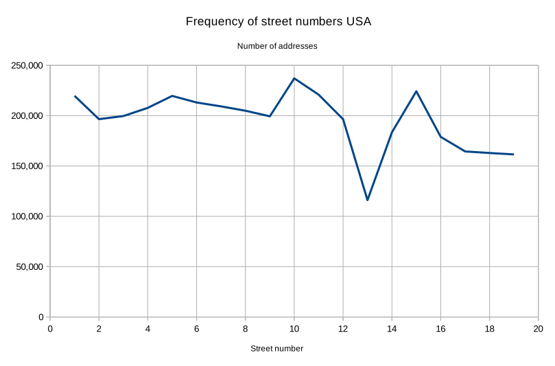
I map a lot of buildings in northern Dublin City. I also interrogate housenumber interpolations, view mapillary for little peeks of the housenumbers that aren’t blurred, and do my own StreetComplete captures to add as many address details as possible. Lately I have noticed something, born from a concern that I was doing something wrong, or making a mistake.

In a few housing developments around Dublin housenumber=13 doesn’t exist. I have heard of such indulgences before, for example some airlines dropping row 13 from seating plans, or the Irish car registration authority famously dropping its numeric system in 2013 to avoid the unluckiest of car numbers.

So out of curiousity I hit OverPass Turbo and launched a series of queries like this into the existing housenumbers. I couldn’t do loads of these so I thought that maybe 19 would be a sufficient sample (42,000 building objects) to make comparisons and establish patterns. snip1

See full entry

Posted by SimonPoole on 23 August 2021 in English.

Today we’ve started rolling out the 1st beta release of 16.0. If you intend to install this, or at a later date the release version, please read the release notes http://vespucci.io/help/en/16.0.0%20Release%20notes/ before installing.

Due to the preparation for targeting Android 11 there have been some changes in where files are stored that you need to know about.

Posted by AntoJvlt on 22 August 2021 in English. Last updated on 23 August 2021.

Introduction

As we are reaching the end of the Google Summer of Code 2021, I would like to share with you the work done on my project “Nominatim QA Analyser”.

Previous diary entries

Project summary

Nominatim is the OSM’s main geocoding software used to process geocoding requests on OpenStreetMap data. The software uses its own database schema which differs from the one used by the main OSM database. As a result, Nominatim processes OSM data in a way that allows to discover a lot of inconsistencies. The idea of the project was to build a Quality Assurance Tool which analyzes the Nominatim database and extracts errors from the OSM data based on a set of rules.

These extracted errors are then made available to everyone through a visual map, so that OSM mappers can correct them easily.

Running example

If you are curious about the result of the project, you can check a running instance here: https://gsoc2021-qa.nominatim.org/front/. It has up to date data which are generated by the backend analyser directly on the production server of Nominatim.

The web application will be set up on the official nominatim.org website later this month or early September. I will update the previously provided link in this diary entry when it will be done.

What has been done

The project is divided into two parts, the first one is the main Data Analyser tool which runs on the Nominatim’s server and the second one is the web application used to visualize the data through a map.

Data Analyser

The github repository of the Data Analyser can be found here: osm-search/Nominatim-Data-Analyser. The whole commits in this repository are from my work. You are free to contribute and help to make the tool better.

The development of this analyser includes:

See full entry

Location: Billeron, Sainte-Solange, Bourges, Cher, Centre-Val de Loire, Metropolitan France, 18220, France
Posted by Deepthij on 21 August 2021 in English. Last updated on 5 September 2021.

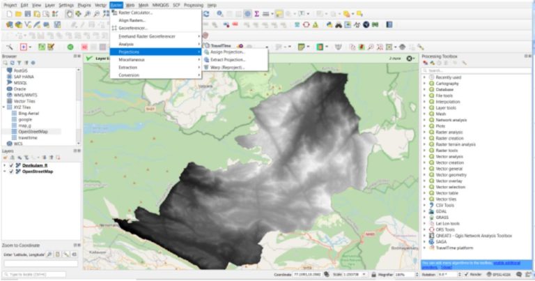
The article represents the method I have used to generate a stream network in a high altitude region in Kerala. The stream network of Devikulam in Munnar is the selected study area and stream and basin is generated using some tools available in QGIS. I am using SRTM DEM with a 30m resolution clipped to the study area and a set of SAGA tools available.

The steps are as follows:

  1. Load the DEM and reproject using the Warp/reprojection tool

The first step is to clip and reproject a DEM into a projected coordinate system. Screenshot Use the option, Raster > Project > Warp/Reproject

Select the required Projected coordinate system with reference to the study area.

  1. Fill Sinks in the reprojected DEM

This step is done to correct any unusual distortions of the DEM and to obtain a continuous hydrological network.

See full entry

Location: Devikulam, Idukki, Kerala, 685613, India

श्री भगवान विद्यालय, बालमटाकळी, तालुका शेवगांव, जिल्हा अहमदनगर. जि.प. प्रा. शाळा, बालमटाकळी, तालुका शेवगांव, जिल्हा अहमदनगर. कर्मवीर एस. एन. हायस्कूल, न्यू बालाजी नगर, औरंगाबाद. Government Polytechnic Aurangabad. Maharashtra College of Engineering, Nilanga Dist. Latur. Swami Ramanand Teerth Marathwada University, Nanded. Maharashtra State Board Of Secondary and Higher Secondary Education, Pune Divisional Board Aurangaabad. अभिनव चित्रशाला, नांदेड। श्री बालंबिका सांस्कृतिक मंडळ बालमटाकळी ता. शेवगाव. महाराष्ट्र राष्ट्रभाषा सभा पुणे। मराठवाडा विज्ञान विकास मंच, औरंगाबाद. श्री शारदा मंदिर कन्या प्रशाला औरंगाबाद. अमानविश्व विद्यालय, औरंगाबाद. मराठवाडा शिक्षण प्रसारक मंडळ. देवगिरी हायस्कूल औरंगाबाद. वेद विज्ञान अनुसंधान संस्था, शिवपुरी अक्कलकोट. महाराणा प्रताप हायस्कूल औरंगाबाद. जगदंबा शिक्षण प्रसारक मंडळ मंठा. सुधाकरराव नाईक हायस्कूल, औरंगाबाद. भ्रष्टाचार विरोधी जन आंदोलन समिती औरंगाबाद. औरंगाबाद जिल्हा यशवंतराव चव्हाण पुण्यतिथी समिती. कर्मवीर श्री शंकरसिंग नाईक हायस्कूल, औरंगाबाद. Directorate of Employment & Self-Employment. Department of Youth Affairs & Sports. Government of India and State Sports Directorates. INDO GERMAN TOOL ROOM, AURANGABAD. The Institution of Engineers (India). ABHINAV VIDYA MANDIR, BHAYANDAR (E), DIST. THANE, MAHARASHTRA. महाराष्ट्र लोकसेवा आयोग. INDIAN ARMY/NAVY, Selection Centre, Bhopal. INDIAN ARMY Selection Centre, Bangalore. कमला नेहरु शिक्षण संस्था, औरंगाबाद. मेहेरसिंग नाईक विद्यालय व कनिष्ठ महाविद्यालय, औरंगाबाद. श्री रंगदास स्वामी शिक्षण विकास मंडळ, आणे.

At HOT’s ‘all staff meeting’ today, we held live finals of the 2021 HOT Staff OSM FIGHT Heavyweight Championship!

2021 HOT Staff OSM FIGHT Heavyweight Championship poster

For those that don’t know, OSM Fight is a website that allows two OSM mappers to compete against each other based on a number of different metrics.

We had started a few weeks ago with team ‘group stages’ and then entered a knock out competition phase. Only the semi-final and final were left to play…

See full entry

I’ve been working on a project for a few months now, and keep getting stuck with time out errors from the Overpass API, which I think might be due to the fact that there are so many postboxes and post offices in the world. (Maybe?)

**Background on the project and ideal vision:

I’m helping the guy who runs postcrossing.com (a free website where people from all over can pull an address and send and receive postcards from each other) to build a map where people can easily find the postbox or post office closest to them in order to mail their postcards. This could be especially helpful if people are on holiday or not close to home and are not super aware of the postboxes and post offices in the area. This would be a map that is embedded in a website - there is no app yet for postcrossing.com and does not seem like there will be on in the near future.

I want the postboxes and post offices to be on different layers, so that I can style the icons individually.

The map should be easy to understand and ideally, would also offer the option to edit if need be (i.e add a postbox or post office that does not yet exist on the map, and be able to add opening hours for the post offices and collection times for the postboxes. There would also be the option to add a photo of the postbox or post office.

**Progress thus far:

I began this project using the Overpass API and putting that information into a uMap, which you can find here: http://u.osmfr.org/m/528331/

I set up the cache under remote data to be once a day, but I still get a red error message that says, “problem in the response,” and gets a 429 error in the console when I move about the map.

I first wrote an OSM Diary entry about this project here: osm.org/user/Nicolelaine/diary/396957

Someone suggested that I create a bounding box, following this French tutorial here: https://wiki.cartocite.fr/doku.php?id=umap:10_-_je_valorise_les_donnees_openstreetmap_avec_umap

See full entry

Introduction

Hi everyone! As GSoC 2021 is coming to a close, I am writing this diary entry as a final report on the progress of my GSoC project, the OpeningHoursEvaluator, in the second period of GSoC.

Previous entries

Project Summary

An evaluator for opening hours tag according to OSM opening hours specification.

Second Period’s Summary

Just to recap, the evaluator from the first period supports almost all the syntaxes defined by the specifications, ranging from something as small as time and a wider range such as year. Building from my previous progress, I have added geocoding to the evaluator, for use in calculation of variable time such as dawn, dusk, sunrise, sunset. I have also added support for holiday data for the corresponding opening hours tag PH and SH, which currently supports 168 countries. Combined with my progress in the first period, the current evaluator now supports evaluation of all the syntax defined by the grammar, and is ready for use in production.

Source code

GitHub repository: https://github.com/goodudetheboy/OpeningHoursEvaluator

Timeline

See full entry